Re: Riverfront Development (Rick's & Storz area)
Posted: Tue Oct 25, 2016 7:16 pm
Go big or go home on this site. It's the only way this will be a viable development, imo. lots of plans floating around.
A Discussion Site for Everything Omaha
https://eomahaforums.com/
Would the Almighty Tuna care to tell us peasants some inside news?almighty_tuna wrote:Go big or go home on this site. It's the only way this will be a viable development, imo. Lots of plans floating around.
I've heard a couple different things. can't speak to specifics. but look at what we've already tried. rick's isn't exactly a big investment though, right? So you polish a turd and make a half-assed effort and call it green space along the river with some food trucks and bs, or make it a destination. the parts are there; bridge extension to connect fahey dr. to the riverfront, blank slate along riverfront drive, potential redevelopment of the conagra space, old power plant apartments. just draw a line along the riverfront, add some dollars. could be great. or could be a continuation of ho-hum. i don't see a real middle ground here that also breeds success.PotatoeEatsFish wrote:Would the Almighty Tuna care to tell us peasants some inside news?almighty_tuna wrote:Go big or go home on this site. It's the only way this will be a viable development, imo. Lots of plans floating around.
iamjacobm wrote:Did the mayor even mention the timeframe for putting out the RFP?
Mayor Jean Stothert has said she expects to issue a request for proposals for the site after the building is demolished
Member berryMTO wrote:Pink berry
iamjacobm wrote:I heard something really big is churning behind the scenes. Like 9 digit budget big.
HR Paperstacks wrote:Member berryMTO wrote:Pink berry
Member Streetcars?HR Paperstacks wrote:Member berryMTO wrote:Pink berry
Ohh, member Jobbers Cannon?Garrett wrote:Member Streetcars?HR Paperstacks wrote:Member berryMTO wrote:Pink berry
Yeah. Council Bluffs is building an office park with housing and retail on their side of the river and Omaha is planning on a sand volleyball court and a food truck. Lead or no lead, Omaha better step it up.omahahawk wrote:iamjacobm wrote:I heard something really big is churning behind the scenes. Like 9 digit budget big.
I'd really like to know more about the 9 digits thing. If that's the case I have to admit I'd be really shocked, quite pleasantly shocked though. That would I mean assume fully gutting the area, doing it right, removing the lead to standards where some real re-development can happen. I'm 100 per cent with Tuna on this, go big or go home. Volleyball courts and food trucks = LAME. Do it right this time and make it a destination. I mean, even as the concrete jungle it is now I'm always surprised at the number of people down there at any given time. Connect the pedestrian bridge to Mike Fahey St., put in a destination attraction (Museum, etc.), more residential, sustainable smaller businesses, and trail connection u p Lauritzen Gardens/Henry Doorly and this thing is a grand slam. I believe the RPS were supposed to be in pretty soon. I think those were just for the Storz site. Hopefully words drops on that soon. Really hope some kind of word comes on the rest of the riverfront and the bigger plans for the area.
MTO wrote:Yeah but Omaha's side already has a few high rises, a couple stadiums, convection center and has to deal with contaminated soil so..
MTO wrote:According to Nebraska law; science is sorcery and art is the devil's pornography.
You can dance in Nebraska as long as it's a polka. Anything else is the devil's work.choke wrote:MTO wrote:According to Nebraska law; science is sorcery and art is the devil's pornography.
Have to go across the state line to dance
MadMartin8 wrote:MTO wrote:Yeah but Omaha's side already has a few high rises, a couple stadiums, convection center and has to deal with contaminated soil so..
Convection Center Omaha. A good place to cook your hot pockets.
Does this mean something is actually going to happen or is this just the city looking to utilize what is currently on the riverfront?
That has been a part of my dreams for a while now. Even if it is just to add more Green Space...Stargazer wrote:It would be cool if we could some how tunnel the rail lines between Abbott and Riverfront Drive, open up the entire area for development (or even further south).
TitosBuritoBarn wrote:Chicago has a lot of places downtown where buildings are on top of railroad tracks as well. In fact the bean is built over a rail yard.
I wonder how much land value affects the viability of a project like this. Downtown Omaha probably has a significantly lower price per acre compared to Chicago and definitely compared to New York. How much does this factor into a cap over the railroad being a viable use of city funds?
Thought this was interesting also:In addition, the panel strongly advocates for the streetcar system on 10th Street that will reduce the auto dependency of the riverfront and eventually allow for the removal of so much surface parking in the riverfront. More regionally, the panel advocates that future bus rapid transit routes cross the I-480 bridge to Council Bluffs and Playland Park. Such service would support transit use of the riverfront to complete trips and support transit-oriented development. Imagine visitors returning to Omaha on public transit after walking over the Bob Kerrey Pedestrian Bridge and visiting Playland.
Moor a barge to the landing to provide additional space for kiosks and outdoor programmed events such as concerts, art fairs, and festivals.
Moor a hotel barge or riverboat to the landing during large events to provide additional rooms during periods of increased demand (Berkshire Hathaway Annual Meeting, College World Series, Olympic Swim Trials, etc.).
I posted about this in 2004, but it never got much traction.Coyote wrote:That has been a part of my dreams for a while now. Even if it is just to add more Green Space...Stargazer wrote:It would be cool if we could some how tunnel the rail lines between Abbott and Riverfront Drive, open up the entire area for development (or even further south).
Omaha just put in a tunnel in this area. It's 3,500 feet long, 17-feet-wide and 70 foot deep (tunneling in this area is tricky because the riverfront). You need to go deep. At $21 million total project cost, that's $6,000 per linear foot. If you tunnel the tracks from Abbott/Riverfront to Dodge Street, near those surface lots, you're looking at roughly a mile, give or take a few hundred feet. Assuming the same cost per linear foot, you're looking at $31.68 million just to put the tunnel in. Granted, I believe a single-track rail line could be built in a smaller tunnel (minimum ~14 feet) but there is more to factor in (ventilation, etc) than the CSO tunnel requires. Safe to say tunneling this isn't an economical option.Brad wrote:I posted about this in 2004, but it never got much traction.Coyote wrote:That has been a part of my dreams for a while now. Even if it is just to add more Green Space...Stargazer wrote:It would be cool if we could some how tunnel the rail lines between Abbott and Riverfront Drive, open up the entire area for development (or even further south).
http://www.eomahaforums.com/viewtopic.php?f=11&t=115
Then back in 2009 they proposed the Grand Lawn over the tracks and the connection to the riverfront area in the "Omaha 2030" Master Plan:
http://urbanplanning.cityofomaha.org/im ... 30_web.pdf
Hopefully by 2030 it will actually be a reality...
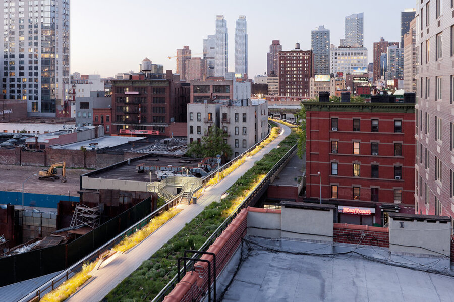
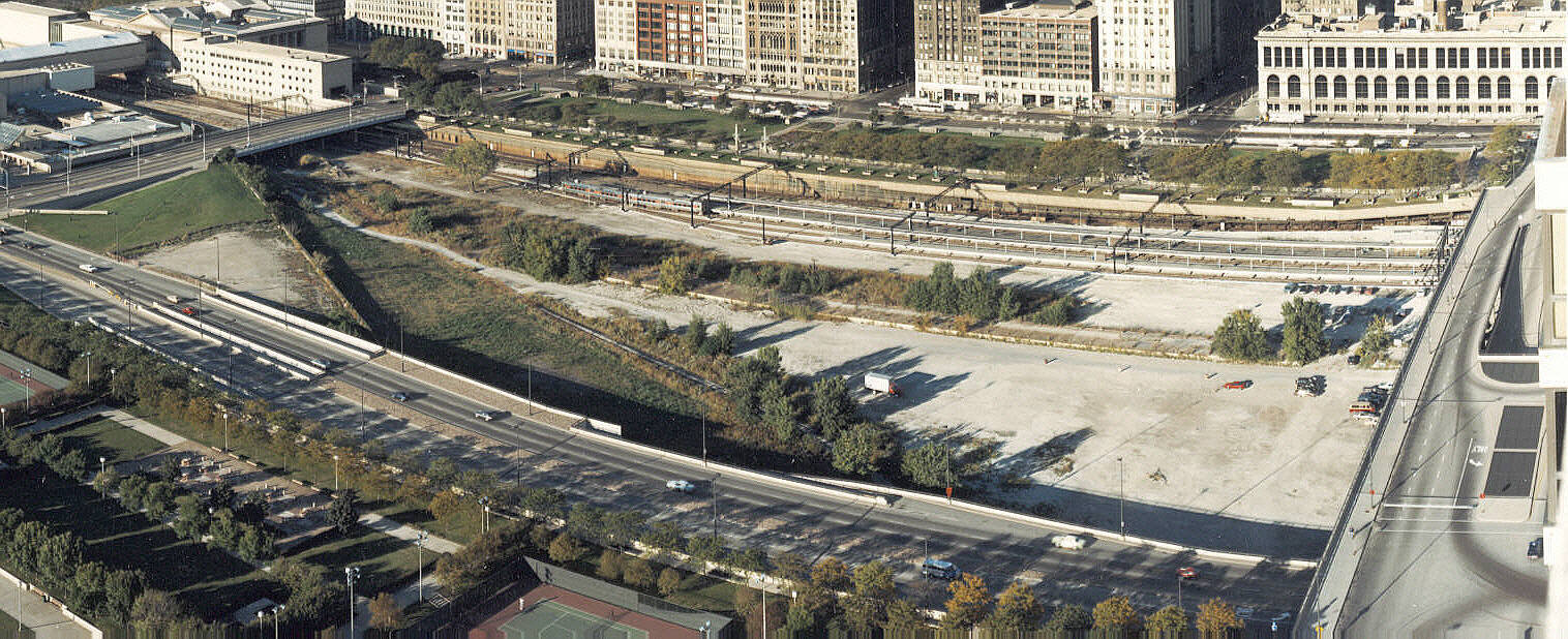
Photo from V. Alexander & Co., Inc wrote:
Apologies for going off topic, but as an Omahan stuck in Chicago, this whole area is fascinating.MTO wrote:
|expletive| I didn't know there were tracks under the bean, I guess that shouldn't surprise me given the extensive underground street network Batman uses.


...the Downtown 2030 Plan (from HDR) is a lid - similar to the one below they built over SR 520 in Washington, not converting an already-existing bridge to a park. https://www.wsdot.wa.gov/NR/rdonlyres/F ... _4web1.jpgJoe_Sovereign wrote:
This is The Highline an abandoned freight rail line bridge in NY that was converted to a park. It wouldn't cost more to cap the railroad tracks than it would to build an equivalent length bridge to cap the rail line. Most likely it would be cheaper if the bridge is only going to have pedestrian traffic and not vehicle traffic.
My apologies, when people say "tunnel" I think "tunnel" (comes from working at an engineering firm - the one everyone seemingly hates on hereBrad wrote:I don't think any of use are expecting a full fledged "tunnel" I was thinking more along the lings of not touching the track, and building some poured Concrete walls for the sides and some sort of cover on top. May be like a smaller version of the Alameda Corridor, but with pedestrian accessible cover on big (or at least key) sections.
That track already sits on the lowest elevations along the riverfront. If they built the walls and piled dirt up on the sides, it would almost blend right in.
Photo from V. Alexander & Co., Inc wrote:
BNSF owns the south part and the UP owns the north part. They switch ownership around the 480 bridge. Back before Heartland of America park the UP had their own access to North Downtown, but after the re-development, they use the BNSF to access their tracks in North Downtown. Their original track ran right through where the lake is now.guest2017 wrote:I honestly do not know who owns those tracks down there (want to say it's UP) and how do we get them to play nice AND foot the bill...
Missouri River Commons page on the Chamber's Website:wowt.com wrote:Rachel Halbmaier is the new Director of the Missouri River Commons.
“Activating the riverfront is just going to drive traffic down to the area and to Omaha,” says Halbmaier. “It's just going to be good for everybody. That's why I'm really excited to be here.”
