NANCY GAARDER WORLD-HERALD STAFF WRITER wrote:The proposed lake at 126th Street and Cornhusker Road would control runoff from about five square miles of the Papillion Creek watershed. It would reduce the West Papio Creek's flow by about 10 percent at downtown Papillion during a 100-year flood, NRD Assistant General Manager Marlin Petermann said.
The 88-acre lake would be open to the public for fishing and have a hiking and biking trail, NRD officials said. However, most of the rest of the land around the lake likely would be private and thus open to housing and commercial development.
Steven Shultz, director of the University of Nebraska at Omaha Real Estate Research Center, told the board that an adequate cost-benefit analysis had not been done — a problem he said exists with other NRD projects. It might be less expensive, he said, to buy out affected properties.
Prairie Queen Recreation Area
Moderators: Coyote, nebugeater, Brad, Omaha Cowboy, BRoss
-
Coyote

- City Council
- Posts: 33289
- Joined: Tue Nov 18, 2003 11:18 am
- Location: Aksarben Village
- Contact:
Prairie Queen Recreation Area
Plans for lake near Papillion advance


New Lake Near Werner Park
http://www.omaha.com/article/20120628/N ... erner-park
Mike Bell, Times Staff Writer wrote:The Papillion area will eventually be home to another lake similar to Walnut Creek where residents and visitors can boat, fish and picnic.
The lake, to be created near 132nd Street and Cornhusker Road, will be about 135 acres in size and will be located just north of Werner Park.
Cornhusker Road will be split, and a bridge will be built over the lake to leave Lincoln Road in place.
The new lake will be bigger than Walnut Creek by about 35 acres of water.
...
[T]he current transfer date for Papillion to take control of the lake is 2025, but it will probably happen much sooner. Plans are in place to construct two picnic shelters, a walking trail, bathrooms and a boat ramp at the lake.

Aerial Photo Update:
1.

2.

1.
2.

Omaha Skyline Photos, Omaha Aerial Photos, and More.
Website: www.bradwilliamsphotography.com
Facebook: www.facebook.com/bradwilliamsphotography
Twitter: www.twitter.com/bradwphoto
Instagram: www.instagram.com/bradwilliamsphotography
YouTube: www.youtube.com/@bradwilliamsphoto
-
omadweller
- Home Owners Association
- Posts: 53
- Joined: Wed Nov 14, 2012 9:54 pm
- Location: Midtown
Rendering of the lake between Cornhusker and 370 by Papillion:
http://www.omahatrails.com/index.php/ar ... tes-trails
http://www.omahatrails.com/index.php/ar ... tes-trails
-
Coyote
- City Council
- Posts: 33289
- Joined: Tue Nov 18, 2003 11:18 am
- Location: Aksarben Village
- Contact:
Papio Watershed WP-5 Reservoir

Project Description:
The West Papillion Regional Basin Number 5 (WP-5) is the first flood control structure proposed as part of the Papillion Creek Watershed Partnership’s Watershed Management Plan. The reservoir is located on Westmont Creek, which is a tributary within the West Papillion Creek Watershed. The project will:
- Address the immediate need for flood control in areas surrounding and including the City of Papillion
- Create a 135 acre lake with an additional 335 acres of park land
- Provide recreational opportunities such as “no wake” boating, fishing, 4 miles of hiking and biking trails, and picnic areas
- Protect highly erodible stream banks from further deterioration
- Improve water quality
- Create an aquatic ecosystem on the site
- Enhance and create wildlife habitat
Estimated Project Costs Dollars
Land Rights $18,200,000
Engineering $3,100,000
WP-5 Construction $14,500,000
Estimated Total Cost $35,800,000
Project Partners Amount
Papio-Missouri River NRD $33,650,000
Nebraska Game & Parks Commission $750,000
Sarpy County $450,000
City of Papillion $450,000
Nebraska Department of Environmental
Quality (anticipated) $500,000
Total $35,800,000
Project Schedule:
- Initial feasibility study began in 2009
- Design completed in August 2012
- Construction of main dam, sanitary sewer relocation, Lincoln Road extension, water quality basins, and recreational features to begin October 2012
- Anticipated completion is June 2014
Last edited by Coyote on Tue Nov 26, 2013 8:10 pm, edited 3 times in total.
-
Coyote
- City Council
- Posts: 33289
- Joined: Tue Nov 18, 2003 11:18 am
- Location: Aksarben Village
- Contact:
Lake may spur growth near Werner Park
Mike Bell: Times Staff Writer wrote:Plans are in place to construct two picnic shelters, a walking trail, bathrooms and a boat ramp at the lake. Future recreational developments are a near-certain possibility, like soccer fields or a horse trail, Grint said. However, those improvements will be up to the City of Papillion to develop and maintain.
-
Coyote
- City Council
- Posts: 33289
- Joined: Tue Nov 18, 2003 11:18 am
- Location: Aksarben Village
- Contact:
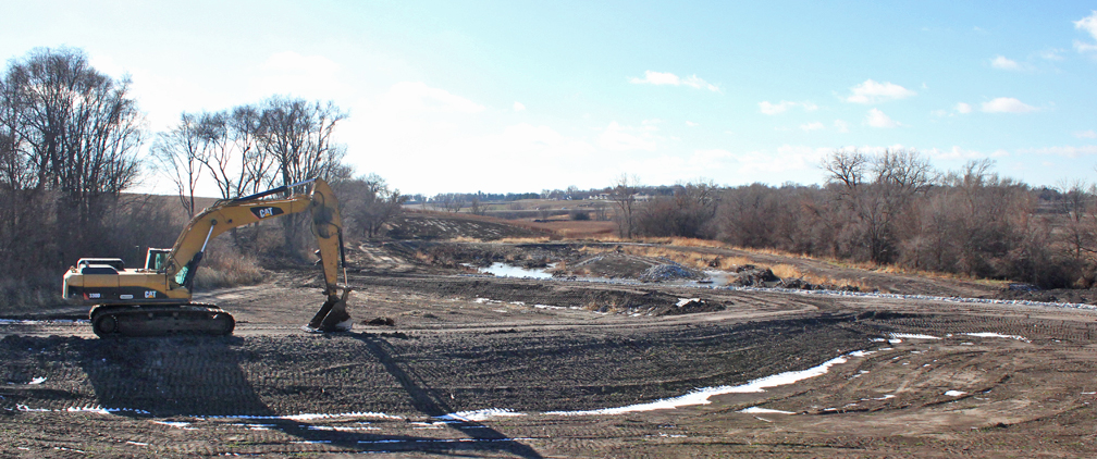
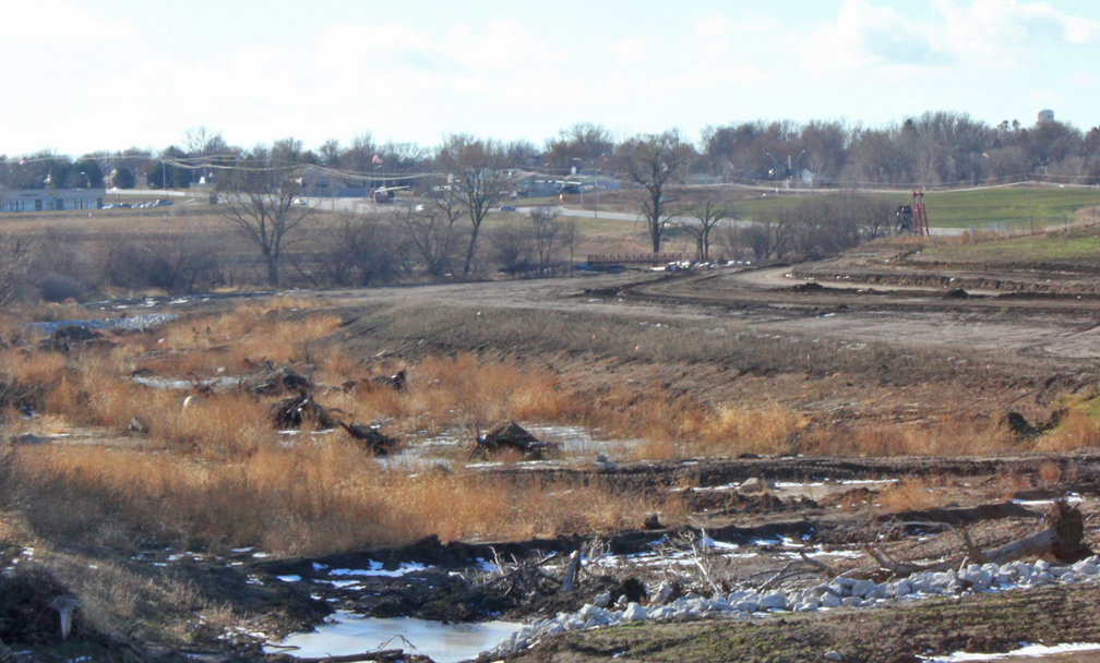
Construction Well Underway For Our Area’s Newest Flood Control Reservoir and Outdoor Recreation Site


Papio NRD wrote:Construction is continuing on the Papio-Missouri River NRD’s WP-5 (West Branch Papio Creek Site 5) Flood Control Reservoir and related outdoor recreational features. The new 135 acre reservoir, surrounded by an additional 335 acres of public parkland, will be near 132nd St and Cornhusker Rd in Sarpy County, just northwest of the Werner Park Stadium.
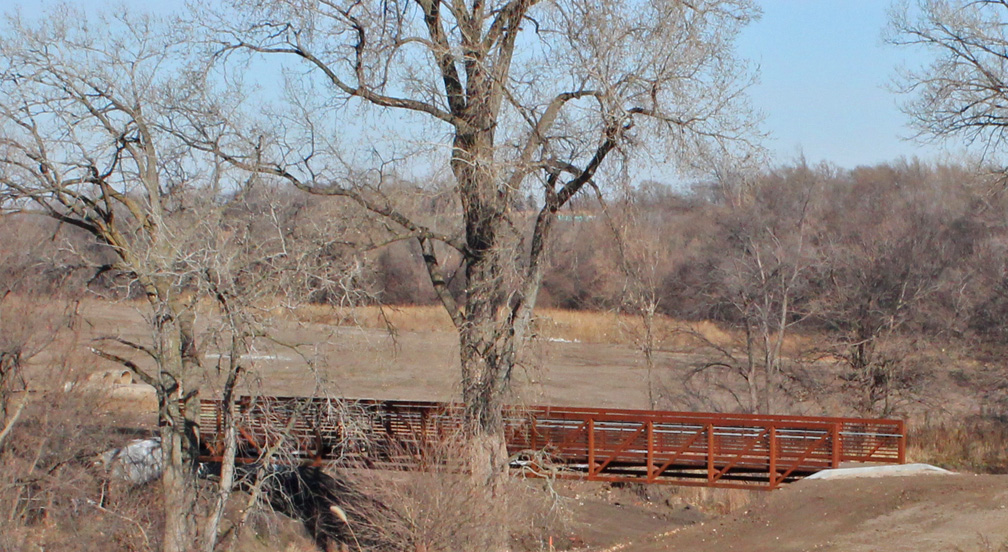
The reservoir project will help protect lives and property downstream along the West Branch Papillion Creek, including the cities of Papillion and Bellevue. Studies have shown that this area of Sarpy County is in dire need of additional flood protection. In addition to the construction of the flood control reservoir, the project also calls for the construction of a hiking/biking trail, boat ramp, picnic shelters, upstream water quality structures and a Lincoln Rd. extension and bridge.
This multi-purpose flood control and outdoor recreation project is the first to be implemented under the Papillion Creek Watershed Partnership’s watershed management plan. The partnership, established in 2001, includes representatives from Omaha, Papillion, Bellevue, Gretna, Boys Town, Ralston, LaVista, Sarpy County and the Natural Resources District. The organization has a mission to address issues related to flooding and water quality in the Papillion Creek watershed in Douglas and Sarpy Counties.
Opening of the recreation area is planned for 2015.
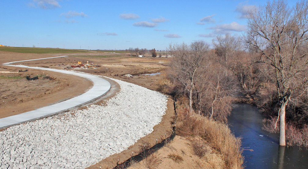
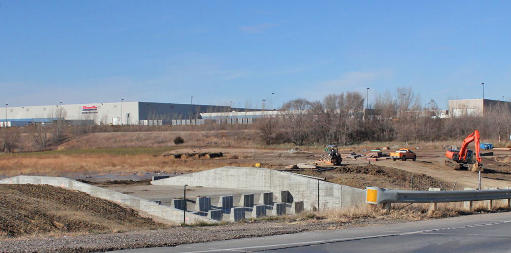

Yeah. I guess I've never seen one that looks like that before outside of a large concrete dam.Coyote wrote:You mean the spillway?RNcyanide wrote:What is the big concrete thing in the second to last picture.
When fortune smiles on something as violent and ugly as revenge, it seems proof like no other that not only does God exist, you're doing his will.
The Bride
The Bride
Nice pics.
Didn't we already have a thread for this? Â I thought I posted aerials if this lake last fall?
Didn't we already have a thread for this? Â I thought I posted aerials if this lake last fall?
Omaha Skyline Photos, Omaha Aerial Photos, and More.
Website: www.bradwilliamsphotography.com
Facebook: www.facebook.com/bradwilliamsphotography
Twitter: www.twitter.com/bradwphoto
Instagram: www.instagram.com/bradwilliamsphotography
YouTube: www.youtube.com/@bradwilliamsphoto
Omaha Skyline Photos, Omaha Aerial Photos, and More.
Website: www.bradwilliamsphotography.com
Facebook: www.facebook.com/bradwilliamsphotography
Twitter: www.twitter.com/bradwphoto
Instagram: www.instagram.com/bradwilliamsphotography
YouTube: www.youtube.com/@bradwilliamsphoto
Re: Papio Watershed WP-5 Reservoir
Water still a long ways from full...

Omaha Skyline Photos, Omaha Aerial Photos, and More.
Website: www.bradwilliamsphotography.com
Facebook: www.facebook.com/bradwilliamsphotography
Twitter: www.twitter.com/bradwphoto
Instagram: www.instagram.com/bradwilliamsphotography
YouTube: www.youtube.com/@bradwilliamsphoto
-
bigredmed
- Parks & Recreation
- Posts: 1897
- Joined: Mon Jun 06, 2011 12:45 pm
- Location: Omaha Metro Area
Re:
RNcyanide wrote:What is the big concrete thing in the second to last picture.
Spillway for flood gate feature of dam. Water flows over the hump and is obstructed by the pieces of concrete. The effect is to slow the flow of the surging water by forcing it to bounce off and between the concrete and the water itself.
When I lived in New Mexico, New Mexico State developed these for arroyo flood control. Arroyos are dry Creek beds that flood much like the Papio does with sudden surges. By controlling the speed of the water, you control the scour and the debris.
Re: Papio Watershed WP-5 Reservoir
I would like to point out that those smaller concrete spillways are not part of the main dam structure. There are smaller sediment basins (look like small reservoirs) where the water enters the lake. These smaller reservoirs collect silt and other derbies and protect the main lake. There is also something similar to this on the south end of Wehrspann Lake. Just south of highway 370.
The other two spillways on the main lake should look similar to what you would see at Lake Zornski or Wehrspann Lake. The Main Spillway will be large concrete box. The Auxiliary (or Emergency) spillway will be long flat grass area. At both Zornski and Wehrspann, both Auxiliary spillways are the soccer fields.
NOTE: I also merged in several posts from the other "Dam Building Thread" that were about this lake.
Omaha Skyline Photos, Omaha Aerial Photos, and More.
Website: www.bradwilliamsphotography.com
Facebook: www.facebook.com/bradwilliamsphotography
Twitter: www.twitter.com/bradwphoto
Instagram: www.instagram.com/bradwilliamsphotography
YouTube: www.youtube.com/@bradwilliamsphoto
-
nosracesahc
- New to the Neighborhood
- Posts: 4
- Joined: Sun Mar 02, 2014 8:21 am
Re: Papio Watershed WP-5 Reservoir
WP-5 GETS A NAME
http://www.omaha.com/article/20140227/SNI02/140228959" onclick="window.open(this.href);return false;
The Papillion City Council voted to name the largest lake and the surrounding space Prairie Queen Recreation Area on Feb. 18.
The name commemorates a one-room country schoolhouse that stood on the site from 1884 to 1957. The building remained in use and served as Papillion Grange Hall until 2002 when Highway 370 was expanded.
-
bigredmed
- Parks & Recreation
- Posts: 1897
- Joined: Mon Jun 06, 2011 12:45 pm
- Location: Omaha Metro Area
Re: Papio Watershed WP-5 Reservoir
Yea for the respect of local history! Nice choice.nosracesahc wrote:WP-5 GETS A NAME
http://www.omaha.com/article/20140227/SNI02/140228959" onclick="window.open(this.href);return false;
The Papillion City Council voted to name the largest lake and the surrounding space Prairie Queen Recreation Area on Feb. 18.
The name commemorates a one-room country schoolhouse that stood on the site from 1884 to 1957. The building remained in use and served as Papillion Grange Hall until 2002 when Highway 370 was expanded.
-
TitosBuritoBarn

- Planning Board
- Posts: 3046
- Joined: Mon Nov 08, 2004 7:08 pm
- Location: St. Louis
Re: Prairie Queen Recreation Area
Sounds like Dairy Queen.
"Video game violence is not a new problem. Who could forget in the wake of SimCity how children everywhere took up urban planning." - Stephen Colbert
Re: Prairie Queen Recreation Area
I noticed this in the article:
I don't think I've seen anything about two more lakes.Two more lakes on the site, one west of 114th Street and the other north and east of 108th Street, will be named at a later date.
-
Coyote
- City Council
- Posts: 33289
- Joined: Tue Nov 18, 2003 11:18 am
- Location: Aksarben Village
- Contact:
Re: Prairie Queen Recreation Area
I believe these 'lakes' are just small ponds north of 370.HR Paperstacks wrote:I noticed this in the article:I don't think I've seen anything about two more lakes.Two more lakes on the site, one west of 114th Street and the other north and east of 108th Street, will be named at a later date.
-
nosracesahc
- New to the Neighborhood
- Posts: 4
- Joined: Sun Mar 02, 2014 8:21 am
Re: Prairie Queen Recreation Area

This is what is on the City of Papillion website Looks to be in the area of NW Corner of 114th and Cornhusker and the second smaller one looks like the area around 108th and W Lincoln Road both area not anywhere close in size to Praire Queen or Walnut
Here is Park Plan
http://www.papillion.org/planning_compr ... e_plan.cfm
-
Coyote
- City Council
- Posts: 33289
- Joined: Tue Nov 18, 2003 11:18 am
- Location: Aksarben Village
- Contact:
Re: Prairie Queen Recreation Area
Nice find, thanks nosracesahc!
Re: Prairie Queen Recreation Area
One of the two lakes has been talked about for a long time, It was in all the initial Werner park renderings and I think is also in the "NRD Dam Building" Thread.
Omaha Skyline Photos, Omaha Aerial Photos, and More.
Website: www.bradwilliamsphotography.com
Facebook: www.facebook.com/bradwilliamsphotography
Twitter: www.twitter.com/bradwphoto
Instagram: www.instagram.com/bradwilliamsphotography
YouTube: www.youtube.com/@bradwilliamsphoto
Re: Prairie Queen Recreation Area
Is there an opening day for the trails? I saw that they were finishing up the southern part yesterday. I am going to try it out tomorrow morning with my fingers crossed that it is done.
-
Coyote
- City Council
- Posts: 33289
- Joined: Tue Nov 18, 2003 11:18 am
- Location: Aksarben Village
- Contact:
Re: Prairie Queen Recreation Area
They were still grooving the sidewalks today, and none of the sidewalks are really completed, plus the parking area is blocked off...Trips wrote:Is there an opening day for the trails? I saw that they were finishing up the southern part yesterday. I am going to try it out tomorrow morning with my fingers crossed that it is done.
Re: Prairie Queen Recreation Area
It looks like they still have 10+ dry days of work. It looks like every .1 miles they skipped a piece of concrete. I am guessing they did not have the distance markers. On a side note it looks like they should have cleaned up the grounds where the lake is going to be.
Re: Prairie Queen Recreation Area
What wasn't cleaned up?Trips wrote:On a side note it looks like they should have cleaned up the grounds where the lake is going to be.
They usually throw a bunch of concrete blocks and tires in there to create fish habitat.
The the water rise a lot yesterday?
Omaha Skyline Photos, Omaha Aerial Photos, and More.
Website: www.bradwilliamsphotography.com
Facebook: www.facebook.com/bradwilliamsphotography
Twitter: www.twitter.com/bradwphoto
Instagram: www.instagram.com/bradwilliamsphotography
YouTube: www.youtube.com/@bradwilliamsphoto
Re: Prairie Queen Recreation Area
The water was up a little but then again that is a huge area that will be filled. I did discover that there is not a whole lot of parking out there unless they have some lots still in the works. As for the junk most of it was concrete, hay bales, tree stumps and construction equipment.
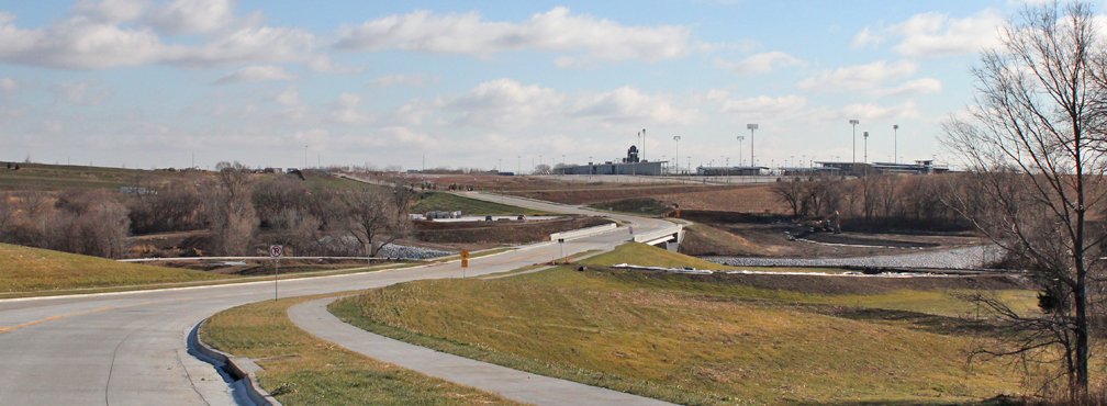
The pictures are from Lincoln Road looking north and south and then 132nd looking east.


The pictures are from Lincoln Road looking north and south and then 132nd looking east.
Re: Prairie Queen Recreation Area
Thanks for the update photos!

.
Nice auto correct! Were they jamming to the 70's while they were getting their grove on?Coyote wrote:They were still grooving the sidewalks today
.
Omaha Skyline Photos, Omaha Aerial Photos, and More.
Website: www.bradwilliamsphotography.com
Facebook: www.facebook.com/bradwilliamsphotography
Twitter: www.twitter.com/bradwphoto
Instagram: www.instagram.com/bradwilliamsphotography
YouTube: www.youtube.com/@bradwilliamsphoto
Re: Prairie Queen Recreation Area
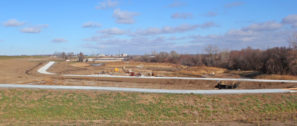
Photo Update
1. Still not much water.

2. Restrooms and picnic areas going in.

1. Still not much water.
2. Restrooms and picnic areas going in.
Omaha Skyline Photos, Omaha Aerial Photos, and More.
Website: www.bradwilliamsphotography.com
Facebook: www.facebook.com/bradwilliamsphotography
Twitter: www.twitter.com/bradwphoto
Instagram: www.instagram.com/bradwilliamsphotography
YouTube: www.youtube.com/@bradwilliamsphoto
Re: Prairie Queen Recreation Area
Aerial Photo Update
1.

2.

3.

4.

5.

6.

7.

8.

9.

10.

11.

12.

13.

14.

15.

16.

17.

1.
2.
3.
4.
5.
6.
7.
8.
9.
10.
11.
12.
13.
14.
15.
16.
17.
Omaha Skyline Photos, Omaha Aerial Photos, and More.
Website: www.bradwilliamsphotography.com
Facebook: www.facebook.com/bradwilliamsphotography
Twitter: www.twitter.com/bradwphoto
Instagram: www.instagram.com/bradwilliamsphotography
YouTube: www.youtube.com/@bradwilliamsphoto
-
Coyote
- City Council
- Posts: 33289
- Joined: Tue Nov 18, 2003 11:18 am
- Location: Aksarben Village
- Contact:
Re: Prairie Queen Recreation Area
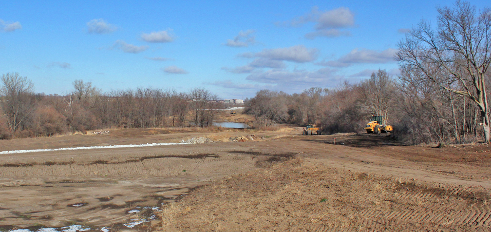
Nice! That is filling in better than I thought.
Re: Prairie Queen Recreation Area
That big rain a couple weeks ago really helped out. Looking at the outlet structure on the dam, its getting close, but still has a ways to go.Coyote wrote:Nice! That is filling in better than I thought.
Omaha Skyline Photos, Omaha Aerial Photos, and More.
Website: www.bradwilliamsphotography.com
Facebook: www.facebook.com/bradwilliamsphotography
Twitter: www.twitter.com/bradwphoto
Instagram: www.instagram.com/bradwilliamsphotography
YouTube: www.youtube.com/@bradwilliamsphoto
-
Coyote
- City Council
- Posts: 33289
- Joined: Tue Nov 18, 2003 11:18 am
- Location: Aksarben Village
- Contact:
Re: Prairie Queen Recreation Area
I also like that new road that leads to the dam. When I get back home tonight I'll have to check a map to see that... 126th St..? Looks like Cornhusker will be piers?