I always start on the street, but I switch to the sidewalk after the 2nd or 3rd car nearly shoves my bike tire into the open curb-style sewers. Â When my pedal grazes your tire, you are TOO CLOSE. Â When I can stick my elbow out and hit the side of your car, you are TOO CLOSE. Â The sidewalk in these situations seems to be the safer option. Â That said, I salivate for expanded bike lanes on Leavenworth.Seth wrote:The ones that seem the worst to me are the casual cyclists who have no concept of their place on the street. The sidewalk is not where you're supposed to be! It's not even as safe as you might think it is!
Metro Area Bicycle Discussion
Moderators: Coyote, nebugeater, Brad, Omaha Cowboy, BRoss
-
Melissa
- Home Owners Association
- Posts: 83
- Joined: Thu Sep 04, 2008 5:35 pm
- Location: Aksarben/Elmwood
“Auditors are the people who show up after the battle and stab the wounded.”
-
StreetsOfOmaha
- City Council
- Posts: 6864
- Joined: Sun Feb 08, 2004 4:46 pm
But oh no, no, no. According to huskerdave, "nobody is preventing you from using your bike to go anywhere you want."Melissa wrote:I always start on the street, but I switch to the sidewalk after the 2nd or 3rd car nearly shoves my bike tire into the open curb-style sewers. When my pedal grazes your tire, you are TOO CLOSE. When I can stick my elbow out and hit the side of your car, you are TOO CLOSE. The sidewalk in these situations seems to be the safer option. That said, I salivate for expanded bike lanes on Leavenworth.Seth wrote:The ones that seem the worst to me are the casual cyclists who have no concept of their place on the street. The sidewalk is not where you're supposed to be! It's not even as safe as you might think it is!
"The right to have access to every building in the city by private motorcar in an age when everyone possesses such a vehicle is actually the right to destroy the city."
Lewis Mumford, The Highway and the City, 1963
Lewis Mumford, The Highway and the City, 1963
-
StreetsOfOmaha
- City Council
- Posts: 6864
- Joined: Sun Feb 08, 2004 4:46 pm
I may have missed it, but I couldn't find the actual thread for the Bike Omaha System...
In any case, this is just as appropriate here I suppose:
I'm surprised no one has mentioned it (and, I guess I don't really know how long they've been up), but the Bike Omaha System wayfinding signs have been put up or are in the process of being put up!!
The sings I saw were as I was heading west on Riverfront Drive near the CLink, then up Capitol Ave. toward 10th.
"The right to have access to every building in the city by private motorcar in an age when everyone possesses such a vehicle is actually the right to destroy the city."
Lewis Mumford, The Highway and the City, 1963
Lewis Mumford, The Highway and the City, 1963
-
StreetsOfOmaha
- City Council
- Posts: 6864
- Joined: Sun Feb 08, 2004 4:46 pm
This is on-street wayfinding, not on the trails (though better wayfinding there would be excellent, too).
I took a couple cell phone photos, but I don't have the same photo hosting abilities I used to have.
I took a couple cell phone photos, but I don't have the same photo hosting abilities I used to have.
"The right to have access to every building in the city by private motorcar in an age when everyone possesses such a vehicle is actually the right to destroy the city."
Lewis Mumford, The Highway and the City, 1963
Lewis Mumford, The Highway and the City, 1963

Bus Racks, More Connections Make Omaha Bike-Friendly
"Cycling has really been picking up in Omaha the last four to five years," said Craig Kelley, the co-founder and social chairman of the Dundee Chain Gang Bicycle Club.
Bike racks on Metro buses and extended trails help cyclists get around with ease.
The idea of biking has grown since 2008, with Metro adding 800 bicyclists in 2010 and seeing a 52 percent jump in bicyclists in 2011, according to an Omaha Metro Bikes on Buses 2011 Year End Report.
Over the last six months, Metro has added signs along the Keystone trail to let people know, whether they're running, biking or walking, that a bus stop is nearby. They've also added signs at the bus stop to let people know their next mode of transportation is close by.
-
StreetsOfOmaha
- City Council
- Posts: 6864
- Joined: Sun Feb 08, 2004 4:46 pm
Thanks for posting that.
Funny, they show the Dundee Chain Gang guy unloading his bike from the back of his minivan and later he talks about how people are using the buses to get to "trail heads." Just kind of funny.
Funny, they show the Dundee Chain Gang guy unloading his bike from the back of his minivan and later he talks about how people are using the buses to get to "trail heads." Just kind of funny.
"The right to have access to every building in the city by private motorcar in an age when everyone possesses such a vehicle is actually the right to destroy the city."
Lewis Mumford, The Highway and the City, 1963
Lewis Mumford, The Highway and the City, 1963

Omaha Bikes finally upgraded from a blog to a full fledged website. Â Looks pretty good.
http://omahabikes.org/
http://omahabikes.org/


http://www.omaha.com/article/20121018/L ... es-to-work
Thursday night, Omaha bicycle commuters will celebrate riding 352,130 miles over the course of five months as part of the Bicycle Commuter Challenge.
777 cyclists, making up 108 teams, participated in the national challenge's sixth year, ranking Omaha 16th for cities and Nebraska third as a state.
-
Coyote

- City Council
- Posts: 33294
- Joined: Tue Nov 18, 2003 11:18 am
- Location: Aksarben Village
- Contact:
Downtown Improvement District adds new bike racks in Old Market

New Bike Racks Are Artwork, Too
KETV wrote:Crews installed six new bike racks Wednesday near 11th and Jackson streets.The Downtown Improvement District said it will add to Omaha’s inviting atmosphere.
New Bike Racks Are Artwork, Too
WOWT wrote:It’s been said that where form meets function you have art. The theory is being tested in the Old Market with a different kind of bike rack. The first of six new bike racks was installed Wednesday morning.
-
StreetsOfOmaha
- City Council
- Posts: 6864
- Joined: Sun Feb 08, 2004 4:46 pm
Thanks for posting.
The bike racks are sorely needed in this area. I have noticed a lot of bicycles locked to light poles and trees in the area.
As I've mentioned, I'd love to see the city replace just ONE car parking space with a bike corral (accommodating approximately 16 bicycles). The Old Market would be the perfect place for a demonstration project.
"The right to have access to every building in the city by private motorcar in an age when everyone possesses such a vehicle is actually the right to destroy the city."
Lewis Mumford, The Highway and the City, 1963
Lewis Mumford, The Highway and the City, 1963

Fort Crook Road now bike-friendly
http://www.omaha.com/article/20130701/L ... e-friendly
http://www.omaha.com/article/20130701/L ... e-friendly
Roseann Moring World-Herald staff writer wrote:Bellevue's first major bike lanes are ready for public riding.
Cyclists can now traverse about five miles of Fort Crook Road within their own lanes in both directions.
The idea is that people can commute or travel for pleasure from Omaha to Offutt Air Force Base and other parts of Bellevue.
“They've just got a nice clean shot down to Offutt without having to worry about traffic,” Public Works Director Jeff Roberts said.
The route connects Bellevue to Omaha on 13th and 24th Streets.

Omaha Skyline Photos, Omaha Aerial Photos, and More.
Website: www.bradwilliamsphotography.com
Facebook: www.facebook.com/bradwilliamsphotography
Twitter: www.twitter.com/bradwphoto
Instagram: www.instagram.com/bradwilliamsphotography
YouTube: www.youtube.com/@bradwilliamsphoto

I noticed these lanes this morning when I was taking my car to the dealership on Fort Crook Road. Â Nice and wide and nicely marked.Brad wrote:Fort Crook Road now bike-friendly
http://www.omaha.com/article/20130701/L ... e-friendly
Roseann Moring World-Herald staff writer wrote:Bellevue's first major bike lanes are ready for public riding.
Cyclists can now traverse about five miles of Fort Crook Road within their own lanes in both directions.
The idea is that people can commute or travel for pleasure from Omaha to Offutt Air Force Base and other parts of Bellevue.
“They've just got a nice clean shot down to Offutt without having to worry about traffic,” Public Works Director Jeff Roberts said.
The route connects Bellevue to Omaha on 13th and 24th Streets.
http://www.omaha.com/article/20130805/N ... -proposals
Nice to see Stothert moving forward on this project. Â I was worried it might go away with her in office.$375,000 for bike lanes, sidewalk improvements and other work on Harney Street from 10th Street to Turner Boulevard. It's the first stage of the project. The bulk of the funding is slated for 2016.


-
Coyote
- City Council
- Posts: 33294
- Joined: Tue Nov 18, 2003 11:18 am
- Location: Aksarben Village
- Contact:
With Mayor Stothert, bike-friendly projects may face more head winds
Erin Golden: World-Herald staff writer wrote:“About 98 percent of the people in Omaha commute by car,” Stothert said. “We may spend millions and millions on alternate forms of transportation, and we may still end up with about 95 percent of the people traveling by car.
“So when you've got to prioritize with a limited amount of funds, it makes sense to put money into our roads resurfacing and maintenance.”
I just read that article. Â I work in this immediate area, I sometime ride my bike to work, but I DO NOT support this "Bridge to Nowhere". Â I will post Photographic Evidence in a little while. Â Still drawing my maps of why its a complete waste.
Omaha Skyline Photos, Omaha Aerial Photos, and More.
Website: www.bradwilliamsphotography.com
Facebook: www.facebook.com/bradwilliamsphotography
Twitter: www.twitter.com/bradwphoto
Instagram: www.instagram.com/bradwilliamsphotography
YouTube: www.youtube.com/@bradwilliamsphoto
Ok, here are some sketches I made up last night.
Figure 1.
Here is the approximate location of the Proposed "Bridge to Nowhere". Â Its ONLY 850' South of the Existing (and almost Brand New) West Dodge Frontage Road Bridge which has a Pedestrian walkway on the south end of it.

Figure 2.
Small sidewalk connection on the east side of the creek near Grisanti's. Â If you look close at Aerials, you can see where people have already worn a trail in to the grass...

Figure 3.
You can clearly see the bike trail that already exists on the bridge and it leads to... No where. Â The sidewalk dead ends at the west side of the bridge! Â (get off on a tangent, but that sidewalk needs to run down to Davenport and then along davenport to 114th the, but there is Zero sidewalk there now, hopefully the hotel builds one). Â Start building at the west end of the bridge and head south.

Figure 4.
Only need about 900' of trail on the west side of the creek to connect in to an existing bike trail that would be at the west end of the proposed "Bridge to No Where"

Basically, you can see this Bridge would be a HUGE waste of money! Â You could accomplish the same thing with 1100'-1200' of new trail. Â Cheap compared to a new bridge.
Figure 1.
Here is the approximate location of the Proposed "Bridge to Nowhere". Â Its ONLY 850' South of the Existing (and almost Brand New) West Dodge Frontage Road Bridge which has a Pedestrian walkway on the south end of it.
Figure 2.
Small sidewalk connection on the east side of the creek near Grisanti's. Â If you look close at Aerials, you can see where people have already worn a trail in to the grass...
Figure 3.
You can clearly see the bike trail that already exists on the bridge and it leads to... No where. Â The sidewalk dead ends at the west side of the bridge! Â (get off on a tangent, but that sidewalk needs to run down to Davenport and then along davenport to 114th the, but there is Zero sidewalk there now, hopefully the hotel builds one). Â Start building at the west end of the bridge and head south.
Figure 4.
Only need about 900' of trail on the west side of the creek to connect in to an existing bike trail that would be at the west end of the proposed "Bridge to No Where"
Basically, you can see this Bridge would be a HUGE waste of money! Â You could accomplish the same thing with 1100'-1200' of new trail. Â Cheap compared to a new bridge.
Omaha Skyline Photos, Omaha Aerial Photos, and More.
Website: www.bradwilliamsphotography.com
Facebook: www.facebook.com/bradwilliamsphotography
Twitter: www.twitter.com/bradwphoto
Instagram: www.instagram.com/bradwilliamsphotography
YouTube: www.youtube.com/@bradwilliamsphoto
http://www.omaha.com/article/20131115/L ... -bike-lane
This sounds like a no brainer. Â That street has no need to be 3 lanes wide considering the type of traffic it carries.A request by Hanscom Park neighbors for the city to slow down speeding traffic on 32nd Avenue could lead to Omaha's first “cycle track,” a physically protected, two-way bike path that's part of a roadway.
Such a route could be built along 32nd Avenue from Woolworth Avenue to Wright Street, a stretch about four-fifths of a mile long that passes Hanscom Park and Our Lady of Lourdes Catholic Church and School.
That's if neighbors don't object too much, and if the City Council approves $80,000 in local funds to go with a $307,000 federal grant already in hand.
-
bigredmed
- Parks & Recreation
- Posts: 1897
- Joined: Mon Jun 06, 2011 12:45 pm
- Location: Omaha Metro Area
Isn't that the street that connects I-480 to Center via Martha? Â That road is busy at times and the third lane is used by the church and handles through traffic to the interstate when the church is busy.iamjacobm wrote:http://www.omaha.com/article/20131115/L ... -bike-lane
This sounds like a no brainer. That street has no need to be 3 lanes wide considering the type of traffic it carries.A request by Hanscom Park neighbors for the city to slow down speeding traffic on 32nd Avenue could lead to Omaha's first “cycle track,” a physically protected, two-way bike path that's part of a roadway.
Such a route could be built along 32nd Avenue from Woolworth Avenue to Wright Street, a stretch about four-fifths of a mile long that passes Hanscom Park and Our Lady of Lourdes Catholic Church and School.
That's if neighbors don't object too much, and if the City Council approves $80,000 in local funds to go with a $307,000 federal grant already in hand.
Well the road switches to only two lanes in front of the church, but it is an exceedingly wide two lane road. Â On that part they could easily add a bike track and not lose any parking or traffic capacity. Â Just slow the cars down to keep it safer. Â The stretch by Hanscom Park is 3 lanes with the extra capacity being northbound traffic away from the interstate exit off of Martha/Ed Creighton. Â I have never seen that part of 32nd Ave with more than 5 cars on it at a time. Â Granted I have never been down there on a Sunday morning, but I can't imagine that extra lane of traffic for less than a half a mile is a huge solution to keeping traffic down.bigredmed wrote:Isn't that the street that connects I-480 to Center via Martha? That road is busy at times and the third lane is used by the church and handles through traffic to the interstate when the church is busy.iamjacobm wrote:http://www.omaha.com/article/20131115/L ... -bike-lane
This sounds like a no brainer. That street has no need to be 3 lanes wide considering the type of traffic it carries.A request by Hanscom Park neighbors for the city to slow down speeding traffic on 32nd Avenue could lead to Omaha's first “cycle track,” a physically protected, two-way bike path that's part of a roadway.
Such a route could be built along 32nd Avenue from Woolworth Avenue to Wright Street, a stretch about four-fifths of a mile long that passes Hanscom Park and Our Lady of Lourdes Catholic Church and School.
That's if neighbors don't object too much, and if the City Council approves $80,000 in local funds to go with a $307,000 federal grant already in hand.
about 2 or 3 blocks of that 12 block stretch the "connection" between center and Martha.bigredmed wrote:Isn't that the street that connects I-480 to Center via Martha? That road is busy at times and the third lane is used by the church and handles through traffic to the interstate when the church is busy.
I agree, I use that street all the time and its never busy enough for what they have. They could easily get away with one lane each way and a couple left turn lanes. Â It seems like most of the church people park on the side streets too.iamjacobm wrote:Well the road switches to only two lanes in front of the church, but it is an exceedingly wide two lane road. On that part they could easily add a bike track and not lose any parking or traffic capacity. Just slow the cars down to keep it safer. The stretch by Hanscom Park is 3 lanes with the extra capacity being northbound traffic away from the interstate exit off of Martha/Ed Creighton. I have never seen that part of 32nd Ave with more than 5 cars on it at a time. Granted I have never been down there on a Sunday morning, but I can't imagine that extra lane of traffic for less than a half a mile is a huge solution to keeping traffic down.
Omaha Skyline Photos, Omaha Aerial Photos, and More.
Website: www.bradwilliamsphotography.com
Facebook: www.facebook.com/bradwilliamsphotography
Twitter: www.twitter.com/bradwphoto
Instagram: www.instagram.com/bradwilliamsphotography
YouTube: www.youtube.com/@bradwilliamsphoto
-
Seth

- Parks & Recreation
- Posts: 1437
- Joined: Mon Jan 11, 2010 4:59 pm
- Location: Ford Birthsite Neighborhood
I had a long response to this typed out, by my browser decided to make it go byebye, so I'll keep it short this time. Â Essentially, while I'd really like to see better bike infrastructure on 32nd (I ride it occasionally), I don't know if this is the best concept. Â I've ridden two-way cycletracks on one side of a street before, and found that turning and crossing intersections to be riskier than directional bike lanes on each side of the street. Â It's an issue for the same reason riding on sidewalks is more dangerous than the street; drivers aren't watching for bikes counter to the normal traffic flow, if they're watching for bikes at all.
Ultimately, I'd rather see this than nothing, but my ideal preference would be directional bike lanes on both sides, and large curb bump-outs at intersections, and maybe mid-block too for long blocks. Â The bike lanes could cut through the bump-outs, which would really reinforce to drivers to stay out of the bike lanes!
Another thing I love about bump-outs: it keeps people from parking up to the corner and obstructing line-of-sights at intersections. Â For instance, people on Park Ave down the street from me are terrible about parking past the no-parking sign at corners, so it's been a huge improvement where they've installed bump-outs.
-
Coyote
- City Council
- Posts: 33294
- Joined: Tue Nov 18, 2003 11:18 am
- Location: Aksarben Village
- Contact:
Re:
Looks like the stalled Mopac trail project is set to resume, connecting the lost 10 mile stretch from Lincoln to Omaha.Bugeater wrote:Finally went out and rode the MOPAC trail this morning, and while I found the southern leg from the Platte River to Springfield to be a very pleasant ride, I was shocked to find out there is no direct connection to the trail north of Springfield. Huge failure there on somebody's part. You either had to ride through a hilly neighborhood or along Hwy 50. Fail, fail fail.
And the condition of the northern leg between Fairview and Schram Rds was appalling considering it is only a few years old. There were numerous rutted, washed out areas and broken glass on the trail. It makes me wonder if it's being maintained at all.
Re: Metro Area Bicycle Discussion
I saw this bike lane down in St. Peterburg FL. last night
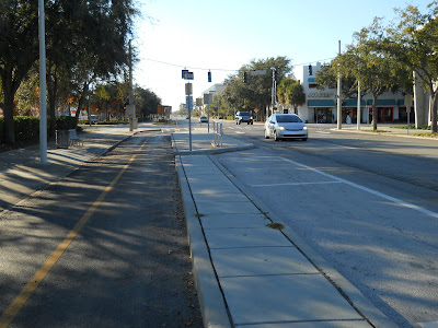
Re: Metro Area Bicycle Discussion
Looks like what we want to do on Harney.
-
GRANDPASMUCKER
- Human Relations
- Posts: 832
- Joined: Tue Mar 11, 2014 3:10 pm
- Location: Omaha
Re: Metro Area Bicycle Discussion
Just read in todays paper that the Bike czar is getting fired from his 70,000 a year job. Thank you thank you thank you Mayor Jean. That woman is the best mayor we have had in Omaha in my life did I say that yet?
Re: Metro Area Bicycle Discussion
Not even a little surprising. The position was partially funded by a number of private groups according to the Live Well article. I would be interested to see what the real bill for the city was. Also I have always hated how he got the czar attached to his position from day one it sends some stupid "Russian socialist" message to the masses that eat that |expletive| up. His actual title of Bicycle & Pedestrian Coordinator describes what his job really is, to help support and foster safe transportation for those that either cannot afford a personal vehicle or chose alternate modes of transportation. This is a step back in Omaha's supposed goal of being a city that supports all it's citizens.
Re: Metro Area Bicycle Discussion
The mayor posted on her Facebook page that she was creating a new volunteer advisory board for "Active Living" which she seems to be making to replace the Bike Czar/Despot/Oppressive sounding title here. She links this article:
http://mayors-office.cityofomaha.org/in ... cle?id=122" onclick="window.open(this.href);return false;
http://mayors-office.cityofomaha.org/in ... cle?id=122" onclick="window.open(this.href);return false;
OMA-->CHI-->NYC
Re: Metro Area Bicycle Discussion
Looks like the 32nd Street plan is moving forward with bump-outs and bikes lanes instead of the dedicated cycle track. Would be a great addition to the system.
Re: Metro Area Bicycle Discussion
I thought there was another thread for this, but I couldn't find it.
Phase two of the Keystone/Field Club connector is in the next agenda.
Phase two of the Keystone/Field Club connector is in the next agenda.
-
mistergutierrez
- Home Owners Association
- Posts: 120
- Joined: Tue Mar 26, 2013 9:28 pm
- Location: Omaha Metro Area
Re: Metro Area Bicycle Discussion
It seems that a bike lane connecting DT CB and Omaha is a step closer:
http://www.nonpareilonline.com/news/loc ... 26031.html" onclick="window.open(this.href);return false;
Efforts to create a walking and biking trail system from downtown Council Bluffs to Omaha’s Old Market continue moving forward.
The Council Bluffs City Council this week voted 4-1 to approve an agreement with the Council Bluffs Community School District for creating a trail through the heart of the Thomas Jefferson High School campus. The path would go east and west on the right-of-way where railroad tracks once ran between the school’s main building and its gym.
A trail running east and west in the area along Second Avenue is the most direct route to the Old Market via the Bob Kerrey Pedestrian Bridge, Mayor Matt Walsh said.
Re: Metro Area Bicycle Discussion
This is good news. This portion of the project has been held up for a while now and is long overdue. The sharrows and bike lanes downtown are great, but the dedicated bike trails need to be completed to allow the safest routes through the city for both recreational and commuting in Omaha. Eventually I may have a safe route to ride from my home near Rockbrook to work in CB. Does anyone know if the city aquired the 2 parcels of land held by the NDOR?iamjacobm wrote:Phase two of the Keystone/Field Club connector is in the next agenda.
Oh, and the link for the Keystone/Field Club connector is here:
http://eomahaforums.com/phpBB/viewtopic.php?t=11756" onclick="window.open(this.href);return false;