Google Maps & Google Earth
Moderators: Coyote, nebugeater, Brad, Omaha Cowboy, BRoss


actually my Macs are very good PC... being that PC means personal computer.
not to get into a mac vs windows argument but i have two computers where i don't have to install special software to take care of adware/spyware/viruses. Rarely goes down or freezes up.
I have read if i was a gamer that windows is the way to go but i outgrew games a long time ago.
not to get into a mac vs windows argument but i have two computers where i don't have to install special software to take care of adware/spyware/viruses. Rarely goes down or freezes up.
I have read if i was a gamer that windows is the way to go but i outgrew games a long time ago.
Wow you all should download Google Earth it is crazy!
http://kh.google.com/download/earth/index.html
here’s a taste. You can make the buildings 3D and tilt/pan around like this its a blast.
Here is New Orleans

And Miami

And last my fav city Chi-Town

http://kh.google.com/download/earth/index.html
here’s a taste. You can make the buildings 3D and tilt/pan around like this its a blast.
Here is New Orleans
And Miami
And last my fav city Chi-Town
15-17, 26, 32


To intentionally get in on the Mac vs Windows thing.... I have both and I like my Macs far more. Just couldn't resist chiming in on this timeless and ongoing topic 

My son got a 27 on his ACT. No this score is not as high as what Jeff's son achieved. But one has to remember the paternal gene-pool my son has to overcome. On a PGPAB [Paternal Gene-Pool Adjusted Basis], my son's score is a 37 and Jeff's son's PGPAB ACT score is 19.

I have both a mac and a windows.
I use my mac for design work and film editing.
I use my windows for games. Or rather, I USED my windows for games, as it became so infested with spyware and viruses that it became nearly useless. My Mac has yet to have a virus or spyware issue, and I don't foresee it having one in the next few years.
Okay me too.
I built macs built macs networks. Troubleshooter macs and their networks....... I also done the same with PCs......... I studied electronics engineering and computer science for years now. Also a lot of information technology and programming....... I’ve discussed this topic with Ph.D.s and people who know more than ill know in my life time. They and I all agree PCs………
I built macs built macs networks. Troubleshooter macs and their networks....... I also done the same with PCs......... I studied electronics engineering and computer science for years now. Also a lot of information technology and programming....... I’ve discussed this topic with Ph.D.s and people who know more than ill know in my life time. They and I all agree PCs………
15-17, 26, 32
I prefer a 4-way Opteron (model 880) system, with dual (SLI) Quadro FX4500s and of course a full compliment of 15,000rpm Ultra 320 HDs on RAID0 (~1.4TBs) and to top it off 64MBs of RAM. With Linux(coming soon) and Windows for boot options. Let see a mac beet that in graphics.I use my mac for design work and film editing.
MWAAAAAAHAHAAHAHAAHAAHAHHAAHAHAHAHAAAAAAAA
15-17, 26, 32
-
Coyote

- City Council
- Posts: 33198
- Joined: Tue Nov 18, 2003 11:18 am
- Location: Aksarben Village
- Contact:
Google's eye in the sky alarms some nations
Omaha World Herald wrote:When Google introduced Google Earth, free software that marries satellite and aerial images with mapping capabilities, the company emphasized its usefulness as a teaching and navigation tool. But since its debut last summer, Google Earth has received attention of an unexpected sort. Officials of several nations have expressed alarm over its detailed display of government buildings, military installations and other sensitive sites within their borders.
-
TechnicalDisaster
- Parks & Recreation
- Posts: 1651
- Joined: Mon Nov 08, 2004 4:47 pm
- Location: In Suburbia Paradise
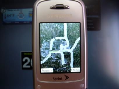
I just checked and google earth mobile has added live traffic to its features. And yes amazingly Omaha is one of only 30 cities that they are doing.
Its free(if you have a data plan) and fun. Launch your WAP browser on your handset go to http://www.google.com/gmm and download that app. Its very small since not much runs natively.
Its free(if you have a data plan) and fun. Launch your WAP browser on your handset go to http://www.google.com/gmm and download that app. Its very small since not much runs natively.
15-17, 26, 32


MTO wrote:I just checked and google earth mobile has added live traffic to its features. And yes amazingly Omaha is one of only 30 cities that they are doing.
Its free(if you have a data plan) and fun. Launch your WAP browser on your handset go to http://www.google.com/gmm and download that app. Its very small since not much runs natively.
We are so moving up!
My son got a 27 on his ACT. No this score is not as high as what Jeff's son achieved. But one has to remember the paternal gene-pool my son has to overcome. On a PGPAB [Paternal Gene-Pool Adjusted Basis], my son's score is a 37 and Jeff's son's PGPAB ACT score is 19.
-
omahastylee459
- Parks & Recreation
- Posts: 1027
- Joined: Sat Dec 25, 2004 4:48 pm
- Location: Nashua, NH
-
Hellenistic Kshatriya
- Home Owners Association
- Posts: 121
- Joined: Fri Jun 02, 2006 3:29 pm
-
Hellenistic Kshatriya
- Home Owners Association
- Posts: 121
- Joined: Fri Jun 02, 2006 3:29 pm
Slightly OT... notice the change in date of the picture on this one. The further west part is acutlaly newer.
EDIT-Right link... http://maps.google.com/maps?hl=en&lr=&s ... a=N&tab=wl
Look to the west at about the 174th and Dodge to Burke area, it's got an aera of newer pictures where you can see the VP parking lot.
EDIT-Right link... http://maps.google.com/maps?hl=en&lr=&s ... a=N&tab=wl
Look to the west at about the 174th and Dodge to Burke area, it's got an aera of newer pictures where you can see the VP parking lot.
-
omahastylee459
- Parks & Recreation
- Posts: 1027
- Joined: Sat Dec 25, 2004 4:48 pm
- Location: Nashua, NH
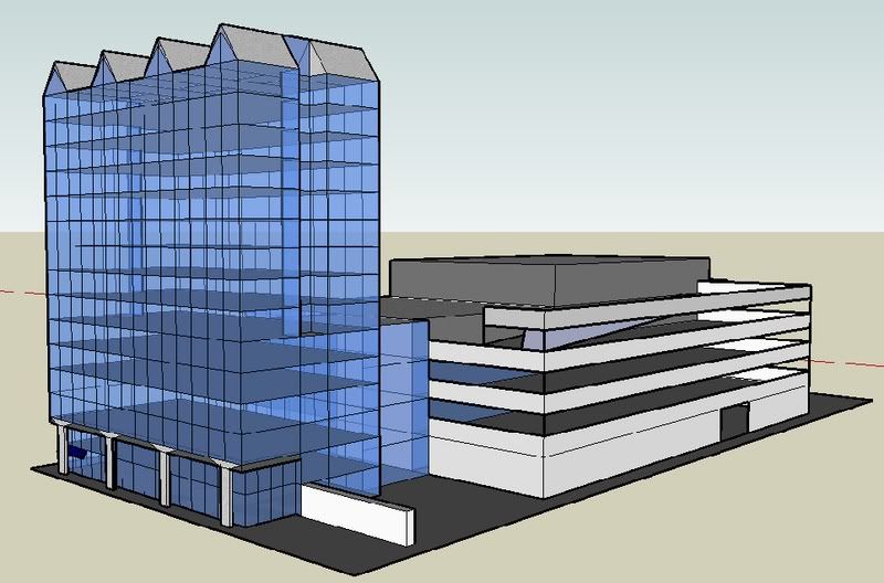
Google SketchUp (Very Cool!)
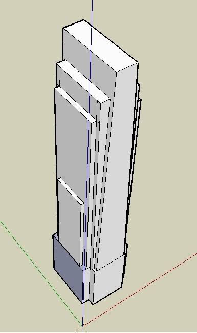
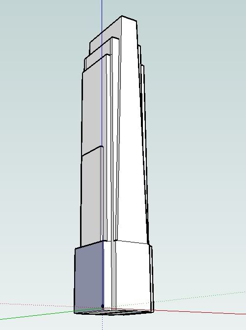
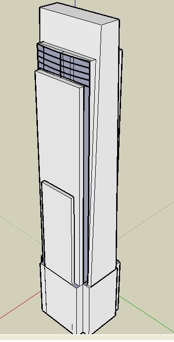
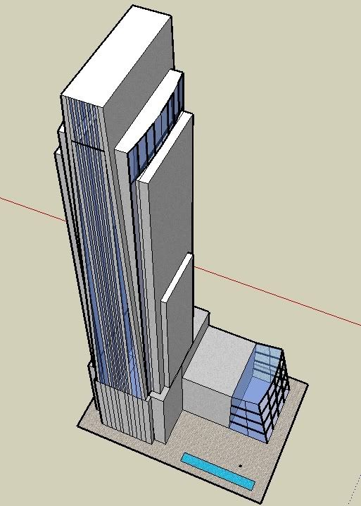
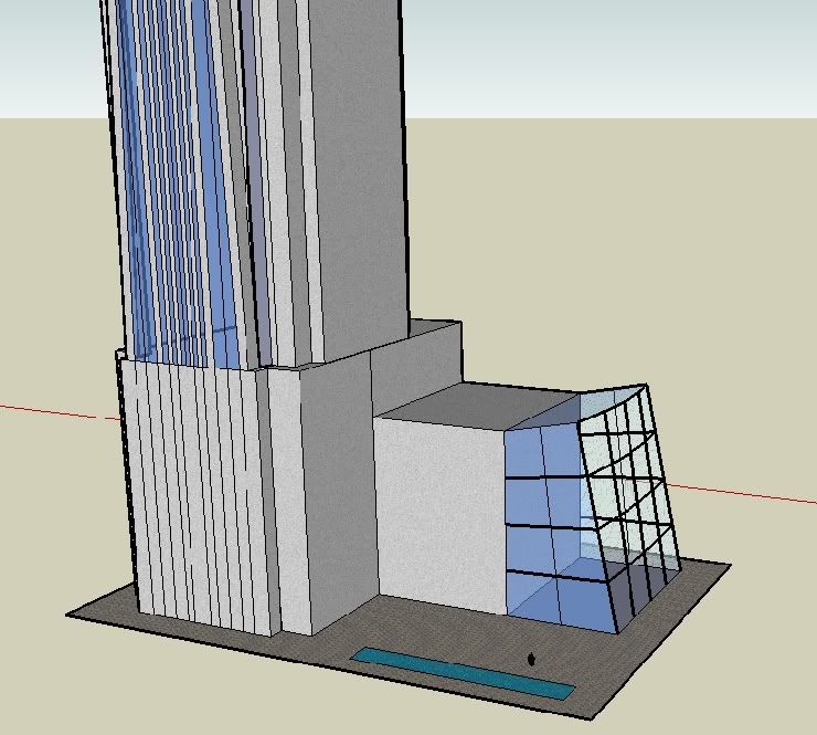
So I found this program today and have been having a blast with it. Â Google SketchUp allows you to make a 3-D model of anything you would like. Â I found that you can also import these models onto Google Earth, so I decided to create FNC, all 634 feet of it. Â It is still a work in progress, but here is what I have so far. Â Later on I will add windows and textures.

Is this what the1wags used over here in the swanson site thread:
http://eomahaforums.com/phpBB/viewtopic ... c&start=90
http://eomahaforums.com/phpBB/viewtopic ... c&start=90

Omaha Skyline Photos, Omaha Aerial Photos, and More.
Website: www.bradwilliamsphotography.com
Facebook: www.facebook.com/bradwilliamsphotography
Twitter: www.twitter.com/bradwphoto
Instagram: www.instagram.com/bradwilliamsphotography
YouTube: www.youtube.com/@bradwilliamsphoto
-
omahastylee459
- Parks & Recreation
- Posts: 1027
- Joined: Sat Dec 25, 2004 4:48 pm
- Location: Nashua, NH


-
omahastylee459
- Parks & Recreation
- Posts: 1027
- Joined: Sat Dec 25, 2004 4:48 pm
- Location: Nashua, NH
If google earth would ever get 3D buildings in Omaha!adam186 wrote:I'm impressed. Now start planting them in Google maps.
Omaha Skyline Photos, Omaha Aerial Photos, and More.
Website: www.bradwilliamsphotography.com
Facebook: www.facebook.com/bradwilliamsphotography
Twitter: www.twitter.com/bradwphoto
Instagram: www.instagram.com/bradwilliamsphotography
YouTube: www.youtube.com/@bradwilliamsphoto
Your have a good start, omahastylee459
I know it will be a lot of work, you should build a 3D Model of, at least the major buildings, of Downtown Omaha in Google SketchUp and post this model here to download as “Google Earth Overlay”. Â I know there is a way to attached this model to Google Earth.
Learn more about Google Earth and 3D modeling at:
http://earth.google.com/
To aid you in building this model, below is photo of a Model of Downtown Omaha display in the lobby of the Omaha Chamber of Commerce.

View toward the “River”

View toward “Midtown”
.
-- -----------------
I know it will be a lot of work, you should build a 3D Model of, at least the major buildings, of Downtown Omaha in Google SketchUp and post this model here to download as “Google Earth Overlay”. Â I know there is a way to attached this model to Google Earth.
Learn more about Google Earth and 3D modeling at:
http://earth.google.com/
To aid you in building this model, below is photo of a Model of Downtown Omaha display in the lobby of the Omaha Chamber of Commerce.
View toward the “River”
View toward “Midtown”
.
-- -----------------

A Google Earth module would be great because Omaha still doesn't have 3D buildings in Google Earth. Â I can't believe that Ann Arbor, MI has 3D buildings but not Omaha! Â Also, if you look at Denver, you'll notice practically all the 3D buildings are colored and look realistic, which I haven't noticed in other cities besides a couple major skyscrapers.