Looking at the elevation of US cities has always been interesting to me, yet lately, I've been doing more research. It's interesting finding that:
1) Colorado Springs sits above 6,000 feet, higher than Denver, the "Mile High City" (at 5,280) feet. Santa Fe, NM sits above 7,000 feet, while Albuquerque is back lower around Denver's 5,000 range elevation. Salt Lake city sits in the 4,000 feet range.
2) One of the greatest differences of elevation over a short distance is between Reno, NV (over 4,000 feet) and Sacramento, CA (around 30 feet, if I remember right). Of course, nearby San Francisco is near sea level.
3) Miami is one of the lowest cities in the USA, sitting just above sea level, while New Orleans sits lower than sea level.
4) Omaha is at around 1,090 feet. Phoenix, AZ is around the same elevation.
5) Omaha sits higher than Des Moines, which sits higher than Chicago. Just as the land slopes upwards between Omaha and Denver, so it is also gaining height west of Chicago to Omaha.
6) Oklahoma City sits around 1,200 feet, while Dallas is only around 500 feet, and Houston is around 80 feet above sea level. The land slopes down to the Gulf...
If you go to Google Earth or Google Maps (which is now 3D), and tilt the plain in 3D view, you can use that tool to look at elevation change between cities, and gain a sense of it. For example, if you hover right above Downtown Denver streets, then start pulling yourself east towards Omaha (without changing your elevation), you eventually get to Omaha, and you're way above the city & looking down at the skyscrapers of Downtown Omaha (because Omaha sits some 4,000 feet lower than Denver). Similarly, if you start right above Omaha's downtown streets, and pull yourself to Chicago, you'll see how the Windy City sits lower (however, the change is much less than Denver to Omaha). Likewise, if you hover midway up Dallas' tallest skyscrapers (around 500 feet off the ground), and start pulling yourself north towards Okla City, you eventually bump into the ground in Oklahoma, because the elevation of the land is going up slowly...
It's been fun. Just pointing it all out....
ELEVATIONS of US CITIES
Moderators: Coyote, nebugeater, Brad, Omaha Cowboy, BRoss
-
RockHarbor
- Planning Board
- Posts: 2093
- Joined: Wed Mar 23, 2005 7:42 am
- Location: Silver State
ELEVATIONS of US CITIES
I can get pushed out because I'm "too much" for some. Then, an observer of me comes suddenly swooping in to "fill my shoes." People are always more accepting of the new one, because their feathers aren't truly ruffled by them. (Yawn) I can count on it every time.

Re: ELEVATIONS of US CITIES
Omaha runs from about 975 on the low side, to 1275 on the high side, over 300' in change! Phoenix is as flat as a board...RockHarbor wrote:4) Omaha is at around 1,090 feet. Phoenix, AZ is around the same elevation.

Omaha Skyline Photos, Omaha Aerial Photos, and More.
Website: www.bradwilliamsphotography.com
Facebook: www.facebook.com/bradwilliamsphotography
Twitter: www.twitter.com/bradwphoto
Instagram: www.instagram.com/bradwilliamsphotography
YouTube: www.youtube.com/@bradwilliamsphoto

Re: ELEVATIONS of US CITIES
Does anyone know the tallest point in Omaha? I assume the river is the lowest. I have heard before that 49th and Dodge is the tallest point, but that could be just urban legend.Brad wrote:Omaha runs from about 975 on the low side, to 1275 on the high side, over 300' in change! Phoenix is as flat as a board...RockHarbor wrote:4) Omaha is at around 1,090 feet. Phoenix, AZ is around the same elevation.
Re: ELEVATIONS of US CITIES
I always thought it was up by Crown Point.iamjacobm wrote:Does anyone know the tallest point in Omaha? I assume the river is the lowest. I have heard before that 49th and Dodge is the tallest point, but that could be just urban legend.
As far as 49th and Dodge, isn't it slightly up there from Dodge to Underwood and then slightly uphill from 49th to 50th?
Omaha Skyline Photos, Omaha Aerial Photos, and More.
Website: www.bradwilliamsphotography.com
Facebook: www.facebook.com/bradwilliamsphotography
Twitter: www.twitter.com/bradwphoto
Instagram: www.instagram.com/bradwilliamsphotography
YouTube: www.youtube.com/@bradwilliamsphoto
-
RockHarbor
- Planning Board
- Posts: 2093
- Joined: Wed Mar 23, 2005 7:42 am
- Location: Silver State
Re: ELEVATIONS of US CITIES
Wow...I didn't know the difference was that great. But, it makes sense with Omaha's rolling terrain, which is the same elevations as the higher farmland on the other side of the Bluffs in Council Bluffs -- bluffs that are around 200-300 feet. In fact, I appreciate Omaha's hills (and ability to look out long distances, from all the vistas around the metro), when I'm in a more flat city. Seriously, even coming around that curve on I-80 east of 42nd Street, heading westward on I-80, I'm amazed at how far you can see to the west. You can look all the way out to 108th & 'L' and see those tall hotels standing, and almost see the southern sprawl of Papillion & La Vista fairly well. It's not hard for me to picture the original landscape of a bare, rolling, grassy prairie before Omaha came to be.Brad wrote:Omaha runs from about 975 on the low side, to 1275 on the high side, over 300' in change! Phoenix is as flat as a board...RockHarbor wrote:4) Omaha is at around 1,090 feet. Phoenix, AZ is around the same elevation.
The tallest point is around 49th & Dodge? Really? I would think near 156th & Maple has to be one of the highest points around, as you can see pretty far from that intersection.
Another interesting elevation change is between Phoenix & Tuscon. I always heard Tuscon was a little higher & cooler than Phoenix, and it sits around 1000 feet higher I've learned. In fact, hovering just above the streets of Downtown Tuscon on Google Maps 3D, I pulled myself north until I reached Phoenix, and I was looking down at all the tops of Phoenix's skyscrapers. Interesting... When you drive between the two cities, it just feels like they are at the same level, being such a gradual change...
I can get pushed out because I'm "too much" for some. Then, an observer of me comes suddenly swooping in to "fill my shoes." People are always more accepting of the new one, because their feathers aren't truly ruffled by them. (Yawn) I can count on it every time.

Re: ELEVATIONS of US CITIES
Back when I lived in the area, it was "common knowledge" amongst the neighbors that the Walnut Hill Reservoir, just east of 40th. St., was the highest elevation. A friend who lived by the Mormon Cemetery in far north Omaha said that it was "common knowledge" that the hill that peaked just west of 33rd and {mumble} was instead the highest. {flip-slap!}iamjacobm wrote:Does anyone know the tallest point in Omaha? I assume the river is the lowest. I have heard before that 49th and Dodge is the tallest point, but that could be just urban legend.
Re: ELEVATIONS of US CITIES
So far, the highest I have found is 1275' up by Omaha Country Club.
Couple Quick Elevations off Google Earth:
Couple Quick Elevations off Google Earth:
Elev 1188'iamjacobm wrote:49th and Dodge.
Good Call, the old Thomas Fitzjareld Veterans home is Elev 1270'RockHarbor wrote:156th & Maple
Close, Elev = 1250'Omababe wrote:Walnut Hill Reservoir, just east of 40th. St
Looks like its about Elev = 1210'Omababe wrote:Mormon Cemetery
Omaha Skyline Photos, Omaha Aerial Photos, and More.
Website: www.bradwilliamsphotography.com
Facebook: www.facebook.com/bradwilliamsphotography
Twitter: www.twitter.com/bradwphoto
Instagram: www.instagram.com/bradwilliamsphotography
YouTube: www.youtube.com/@bradwilliamsphoto
Re: ELEVATIONS of US CITIES
It is downhill from 49th to 50th on Dodge, but you are obviously right about it not being the highest. Just one of those neighborhood stories you hear and never question.

Re: ELEVATIONS of US CITIES
The North Omaha Airport is at 1320'. That's the highest I've found in Douglas County so far. There are several locations over 1300'. On the DOGIS website you can turn-on the 2' contour interval layer and see what all of the elevations are. The DC landfill in NW Douglas county might have a chance to eventually get higher if we keep piling it on. Might make a good ski area someday too.
He said "They are some big, ugly red brick buildings"
...and then they were gone.
...and then they were gone.
Re: ELEVATIONS of US CITIES
Not surprising. I really only looked in Omaha proper.
Omaha Skyline Photos, Omaha Aerial Photos, and More.
Website: www.bradwilliamsphotography.com
Facebook: www.facebook.com/bradwilliamsphotography
Twitter: www.twitter.com/bradwphoto
Instagram: www.instagram.com/bradwilliamsphotography
YouTube: www.youtube.com/@bradwilliamsphoto
-
GRANDPASMUCKER
- Human Relations
- Posts: 832
- Joined: Tue Mar 11, 2014 3:10 pm
- Location: Omaha
Re: ELEVATIONS of US CITIES
That might be one of the main reasons as to why the Air Force put that base right there.GetUrban wrote:The North Omaha Airport is at 1320'. That's the highest I've found in Douglas County so far. There are several locations over 1300'. On the DOGIS website you can turn-on the 2' contour interval layer and see what all of the elevations are. The DC landfill in NW Douglas county might have a chance to eventually get higher if we keep piling it on. Might make a good ski area someday too.
-
RockHarbor
- Planning Board
- Posts: 2093
- Joined: Wed Mar 23, 2005 7:42 am
- Location: Silver State
Re: ELEVATIONS of US CITIES
Walnut Hill...east of 40th St? Never heard of it...
Thanks for your replies, and the local elevations. I just knew that 156th & Maple had to be one of the highest hills... That's one of my favorite places in town. I always like the high points in the metro -- it seems.
What is this site you guys get local elevations of the Omaha area? Sounds neat...
Thanks for your replies, and the local elevations. I just knew that 156th & Maple had to be one of the highest hills... That's one of my favorite places in town. I always like the high points in the metro -- it seems.
What is this site you guys get local elevations of the Omaha area? Sounds neat...
I can get pushed out because I'm "too much" for some. Then, an observer of me comes suddenly swooping in to "fill my shoes." People are always more accepting of the new one, because their feathers aren't truly ruffled by them. (Yawn) I can count on it every time.
Re: ELEVATIONS of US CITIES
Just drive south of Hamilton on 38th.RockHarbor wrote:Walnut Hill...east of 40th St? Never heard of it...
Re: ELEVATIONS of US CITIES
It was an Air Force radar site rather than a typical air force base, of course. I'm not sure if the North Omaha Airport and runway north of Bennington Rd./Mckinley was part of the radar site or if it was developed separately. It seems I remember the radar site had a landing strip too.GRANDPASMUCKER wrote:That might be one of the main reasons as to why the Air Force put that base right there.GetUrban wrote:The North Omaha Airport is at 1320'. That's the highest I've found in Douglas County so far. There are several locations over 1300'. On the DOGIS website you can turn-on the 2' contour interval layer and see what all of the elevations are. The DC landfill in NW Douglas county might have a chance to eventually get higher if we keep piling it on. Might make a good ski area someday too.
https://en.wikipedia.org/wiki/Omaha_Air_Force_Station
He said "They are some big, ugly red brick buildings"
...and then they were gone.
...and then they were gone.
Re: ELEVATIONS of US CITIES
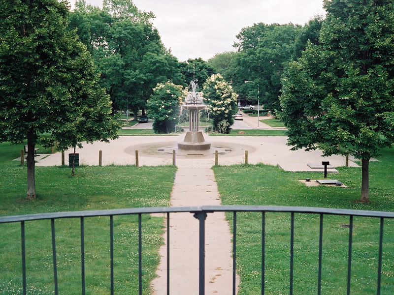
I always think of the huge water tank.Omababe wrote:Just drive south of Hamilton on 38th.RockHarbor wrote:Walnut Hill...east of 40th St? Never heard of it...
- walnut.JPG (226.77 KiB) Viewed 2841 times
Omaha Skyline Photos, Omaha Aerial Photos, and More.
Website: www.bradwilliamsphotography.com
Facebook: www.facebook.com/bradwilliamsphotography
Twitter: www.twitter.com/bradwphoto
Instagram: www.instagram.com/bradwilliamsphotography
YouTube: www.youtube.com/@bradwilliamsphoto
-
RockHarbor
- Planning Board
- Posts: 2093
- Joined: Wed Mar 23, 2005 7:42 am
- Location: Silver State
Re: ELEVATIONS of US CITIES
Thanks for those pictures. I have never heard of that Walnut Hill park, nor even knew about that fountain. Surely, in all my years in Omaha, I've probably passed by it before -- at least once, I would think. I'm not that far from there, so I'll have to swing by someday.
I can get pushed out because I'm "too much" for some. Then, an observer of me comes suddenly swooping in to "fill my shoes." People are always more accepting of the new one, because their feathers aren't truly ruffled by them. (Yawn) I can count on it every time.
Re: ELEVATIONS of US CITIES
That fountain actually dates from the early 1900s but it has not been operational continuously.RockHarbor wrote:Thanks for those pictures. I have never heard of that Walnut Hill park, nor even knew about that fountain.
When I lived in the area the fountain did not work and was fenced off. There was also a second (not operating) fountain up the hill a bit. IIRC it was about 1990 when they rebuilt and reopened it.
-
RockHarbor
- Planning Board
- Posts: 2093
- Joined: Wed Mar 23, 2005 7:42 am
- Location: Silver State
Re: ELEVATIONS of US CITIES
Interesting... Thanks for the info. I'm planning to check that area out. I've just never heard the term "Walnut Hill" in Omaha, so it rings strange to me. I've been to Walnut Grove (park) plenty of times, out near 156th & 'Q.'
Speaking of highest points in the metro, I'm sure the hilltop crest midway between 90th & Dodge & Westroads Mall has to be another. 90th & Dodge has a great view of Omaha, and that intersection is below the crest of the hill. In fact, I've felt that great big hill was the reason why West Dodge Road has that major curve there. It was a big enough hill, I think they felt they needed to curve the highway around it. The original "Dodge St.", running straight the Methodist complex to 84th St, is pretty steep.
Another high point in the metro has to be over in the Bergan Mercy Hospital area. There's a pretty good view of Omaha from up there. Also, the high hill (that was plateaued out) the apartment complex sits on just west of 180th & Dodge has to be another.
In West Omaha, they really flatten the land out before they develop now. So, that is making a difference...
I can get pushed out because I'm "too much" for some. Then, an observer of me comes suddenly swooping in to "fill my shoes." People are always more accepting of the new one, because their feathers aren't truly ruffled by them. (Yawn) I can count on it every time.
-
Dundeemaha

- Human Relations
- Posts: 556
- Joined: Thu Apr 04, 2013 11:41 am
- Location: Country Club
Re: ELEVATIONS of US CITIES
Here's a great article about the history of the Walnut Hill Reservoir: https://northomahahistory.com/2015/11/2 ... reservoir/
Some nice old photos and drawn postcards as well.
Some nice old photos and drawn postcards as well.
-
RockHarbor
- Planning Board
- Posts: 2093
- Joined: Wed Mar 23, 2005 7:42 am
- Location: Silver State
Re: ELEVATIONS of US CITIES
Thanks! I don't have time right at the moment, but I'm so looking forward to clicking on that link and learning more later... Thanks again.Dundeemaha wrote:Here's a great article about the history of the Walnut Hill Reservoir: https://northomahahistory.com/2015/11/2 ... reservoir/
Some nice old photos and drawn postcards as well.
I can get pushed out because I'm "too much" for some. Then, an observer of me comes suddenly swooping in to "fill my shoes." People are always more accepting of the new one, because their feathers aren't truly ruffled by them. (Yawn) I can count on it every time.
-
Busguy2010

- County Board
- Posts: 5334
- Joined: Sat Apr 09, 2011 7:32 pm
- Location: North Central Omaha
Re: ELEVATIONS of US CITIES
33rd and Belvedere Boulevard was what I heard was the highest point in Omaha. Couldn't tell you where I heard this, but I've been up there a couple times and you can see very far. I suggest taking a trip up there. Not only is it cool to be up there, it is an adventure taking the boulevard back down to 30th street with the elevation change and curvy road.
Come to think of it, I probably read that while learning about our boulevard system. At the time the boulevards were built, it probably was the highest known point. It would be interesting to know the actual elevation.
Come to think of it, I probably read that while learning about our boulevard system. At the time the boulevards were built, it probably was the highest known point. It would be interesting to know the actual elevation.
-
RockHarbor
- Planning Board
- Posts: 2093
- Joined: Wed Mar 23, 2005 7:42 am
- Location: Silver State
Re: ELEVATIONS of US CITIES
Interesting. I looked up the area you mentioned. I never noticed that curvy Belvedere Blvd before (on a map of Omaha, or Google Maps). It's funny, there's another unique "kink" in Omaha's grid almost right at 33rd as well, but this one is at 34th & Turner Blvd. It's right where Pacific St runs through there. But, Pacific doesn't connect due to this area, because there is a steep hill/incline, and the sharp curves of Turner Blvd take you up/down the hill. It's a neat little area that I came across one day in my car (about 5 years back) that I had no idea existed. Looking it up on a Omaha map & Google Maps, I'm surprised I never noticed the sudden break in the city's grid within this section. It's like a ravine, so the city couldn't continue the grid over it, so they had to curve a street down it. It's a little fun area. There's a walkway, too.Busguy2010 wrote:33rd and Belvedere Boulevard was what I heard was the highest point in Omaha. Couldn't tell you where I heard this, but I've been up there a couple times and you can see very far. I suggest taking a trip up there. Not only is it cool to be up there, it is an adventure taking the boulevard back down to 30th street with the elevation change and curvy road.
Come to think of it, I probably read that while learning about our boulevard system. At the time the boulevards were built, it probably was the highest known point. It would be interesting to know the actual elevation.
I can get pushed out because I'm "too much" for some. Then, an observer of me comes suddenly swooping in to "fill my shoes." People are always more accepting of the new one, because their feathers aren't truly ruffled by them. (Yawn) I can count on it every time.
