
2012 Severe Weather Thread
First Tornado Warning of the year. Â Going on near Holdrege, NE (SE of Kearney) moving towards Kearney. Â Two Chasers on it, no funnels that I have seen on their cameras yet.
2012 Severe Weather Thread
Moderators: Coyote, nebugeater, Brad, Omaha Cowboy, BRoss
2012 Severe Weather Thread

Omaha Skyline Photos, Omaha Aerial Photos, and More.
Website: www.bradwilliamsphotography.com
Facebook: www.facebook.com/bradwilliamsphotography
Twitter: www.twitter.com/bradwphoto
Instagram: www.instagram.com/bradwilliamsphotography
YouTube: www.youtube.com/@bradwilliamsphoto
-
almighty_tuna
- City Council
- Posts: 105459
- Joined: Tue Apr 13, 2004 1:34 pm
- Location: Somewhere between downtown and Colorado
- Contact:

I saw that earlier.... Absolutely Crazy!!!
Omaha Skyline Photos, Omaha Aerial Photos, and More.
Website: www.bradwilliamsphotography.com
Facebook: www.facebook.com/bradwilliamsphotography
Twitter: www.twitter.com/bradwphoto
Instagram: www.instagram.com/bradwilliamsphotography
YouTube: www.youtube.com/@bradwilliamsphoto
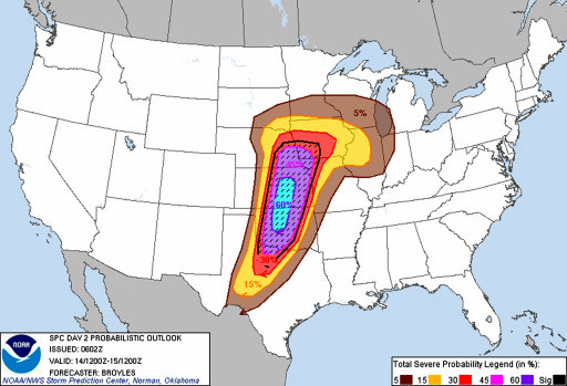
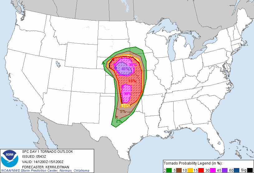
The Storm Prediction Center has Upgraded the outlook for Tomorrow (Saturday 4/14/2012). Â Looks to be a serious situation.

Omaha Skyline Photos, Omaha Aerial Photos, and More.
Website: www.bradwilliamsphotography.com
Facebook: www.facebook.com/bradwilliamsphotography
Twitter: www.twitter.com/bradwphoto
Instagram: www.instagram.com/bradwilliamsphotography
YouTube: www.youtube.com/@bradwilliamsphoto

-
almighty_tuna
- City Council
- Posts: 105459
- Joined: Tue Apr 13, 2004 1:34 pm
- Location: Somewhere between downtown and Colorado
- Contact:


This tornado on the East End of CB didn't get much attention.
National Weather Service wrote:...DAMAGE SURVEY RESULTS FIND AN EF1 TORNADO IN POTTAWATTAMIE COUNTY
IOWA JUST EAST OF COUNCIL BLUFFS...
THE FOLLOWING IS AN ASSESSMENT FOR THE DAMAGE THAT OCCURRED JUST
EAST OF COUNCIL BLUFFS DURING THE VERY EARLY MORNING HOURS ON APRIL
15.
* EVENT DATE...APRIL 15
* ESTIMATED START TIME...12:55 AM CDT
* EVENT TYPE...EF1 TORNADO
* EVENT LOCATION...4.5 MILES SOUTHWEST OF MCCLELLAND IOWA TO
 3.5 MILES SOUTHWEST OF MCCLELLAND IOWA
* PEAK WIND...100 MPH (EF1)
* AVERAGE PATH WIDTH...0.25 MILE
* PATH LENGTH...1 MILE
* INJURIES...NONE
* FATALITIES...NONE
* DISCUSSION/DAMAGE...THE TORNADO TOUCHED DOWN NEAR THE ENTRANCE OF
 THE WESTFAIR AMPHITHEATER...THEN TRACKED ACROSS THE FACILITY
 GROUNDS...AND LIFTED ABOUT 1 MILE LATER.  NUMEROUS TREES AND
 OUTBUILDINGS SUSTAINED DAMAGE.
Omaha Skyline Photos, Omaha Aerial Photos, and More.
Website: www.bradwilliamsphotography.com
Facebook: www.facebook.com/bradwilliamsphotography
Twitter: www.twitter.com/bradwphoto
Instagram: www.instagram.com/bradwilliamsphotography
YouTube: www.youtube.com/@bradwilliamsphoto
-
almighty_tuna
- City Council
- Posts: 105459
- Joined: Tue Apr 13, 2004 1:34 pm
- Location: Somewhere between downtown and Colorado
- Contact:
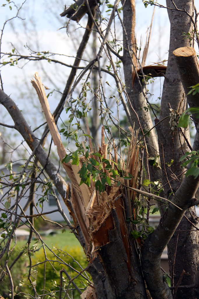
The wind was actually higher yesterday than during the storms. Â We lost a big tree branch yesterday. Â Guessing its a wood fence?almighty_tuna wrote:After all of this darn weather, we lose our fence in yesterday's high wind. How freaking lame is that!
Omaha Skyline Photos, Omaha Aerial Photos, and More.
Website: www.bradwilliamsphotography.com
Facebook: www.facebook.com/bradwilliamsphotography
Twitter: www.twitter.com/bradwphoto
Instagram: www.instagram.com/bradwilliamsphotography
YouTube: www.youtube.com/@bradwilliamsphoto
I was at the HorseShoe after the Buffet concert during this exact time and they didnt say anything or did we hear sirens. heck we didn't even know that another storm moved through after we left.Brad wrote:This tornado on the East End of CB didn't get much attention.
National Weather Service wrote:...DAMAGE SURVEY RESULTS FIND AN EF1 TORNADO IN POTTAWATTAMIE COUNTY
IOWA JUST EAST OF COUNCIL BLUFFS...
THE FOLLOWING IS AN ASSESSMENT FOR THE DAMAGE THAT OCCURRED JUST
EAST OF COUNCIL BLUFFS DURING THE VERY EARLY MORNING HOURS ON APRIL
15.
* EVENT DATE...APRIL 15
* ESTIMATED START TIME...12:55 AM CDT
* EVENT TYPE...EF1 TORNADO
* EVENT LOCATION...4.5 MILES SOUTHWEST OF MCCLELLAND IOWA TO
3.5 MILES SOUTHWEST OF MCCLELLAND IOWA
* PEAK WIND...100 MPH (EF1)
* AVERAGE PATH WIDTH...0.25 MILE
* PATH LENGTH...1 MILE
* INJURIES...NONE
* FATALITIES...NONE
* DISCUSSION/DAMAGE...THE TORNADO TOUCHED DOWN NEAR THE ENTRANCE OF
THE WESTFAIR AMPHITHEATER...THEN TRACKED ACROSS THE FACILITY
GROUNDS...AND LIFTED ABOUT 1 MILE LATER. NUMEROUS TREES AND
OUTBUILDINGS SUSTAINED DAMAGE.

-
almighty_tuna
- City Council
- Posts: 105459
- Joined: Tue Apr 13, 2004 1:34 pm
- Location: Somewhere between downtown and Colorado
- Contact:
Yep. Snapped three 4x4 posts at the base.Brad wrote:The wind was actually higher yesterday than during the storms. We lost a big tree branch yesterday. Guessing its a wood fence?almighty_tuna wrote:After all of this darn weather, we lose our fence in yesterday's high wind. How freaking lame is that!
-
nebugeater

- City Council
- Posts: 108967
- Joined: Wed Aug 04, 2004 6:07 pm
- Location: Gretna NE
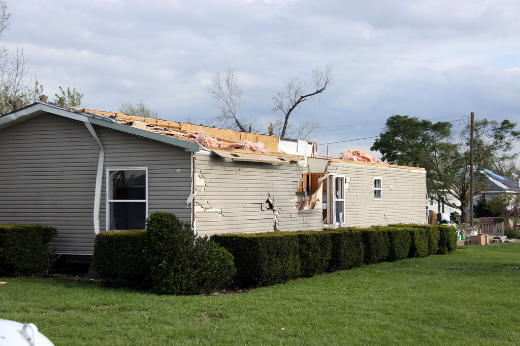
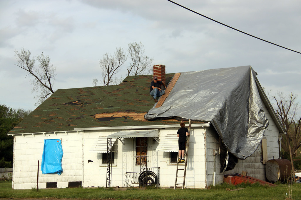
I as in Thurman on Wednesday to help a co-worker that got hit. here are a few quick shots of the town after a couple of days of cleanup already done.
Thurman 2012 Tornado 0140 by nebugeater, on Flickr
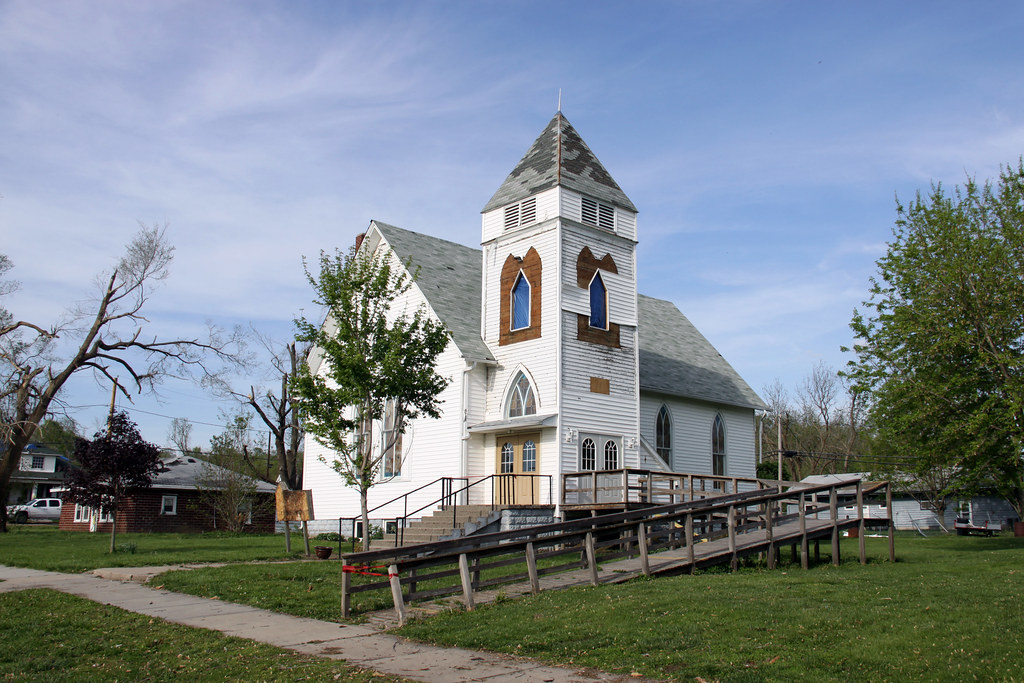
Sounds like this church is a total loss due to structural damage
Thurman 2012 Tornado 0116 by nebugeater, on Flickr
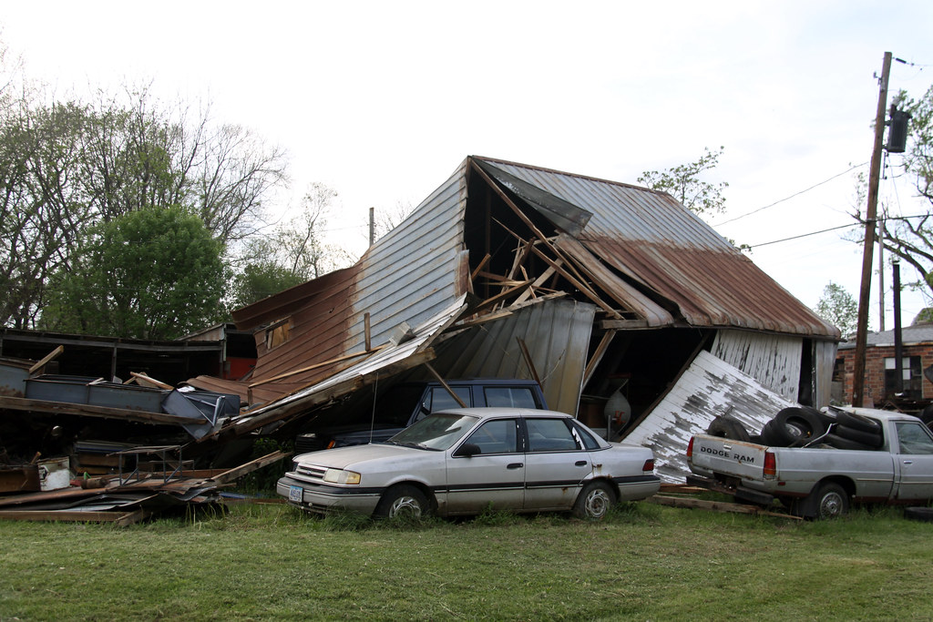
Thurman 2012 Tornado 0171 by nebugeater, on Flickr
Thurman 2012 Tornado 0137 by nebugeater, on Flickr
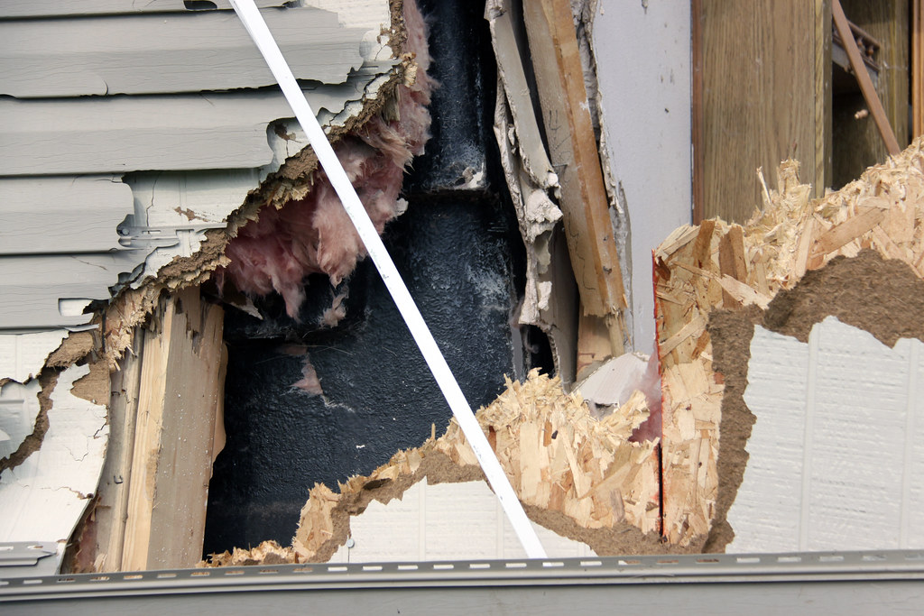
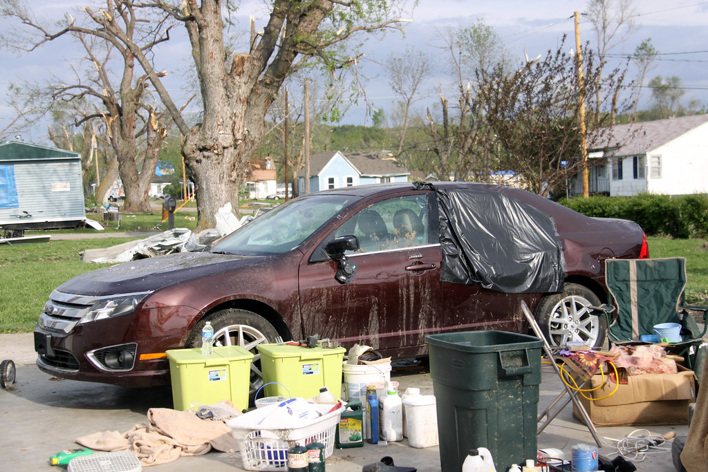
New car had less than 4K miles on it. Totaled. It was in the garage, problem is the Garage is gone.
Thurman 2012 Tornado 0148 by nebugeater, on Flickr
Thurman 2012 Tornado 0161 by nebugeater, on Flickr
Thurman 2012 Tornado 0156 by nebugeater, on Flickr
A few more here.
http://www.flickr.com/photos/nebugeater ... 949974712/
Thurman 2012 Tornado 0140 by nebugeater, on Flickr
Sounds like this church is a total loss due to structural damage
Thurman 2012 Tornado 0116 by nebugeater, on Flickr
Thurman 2012 Tornado 0171 by nebugeater, on Flickr
Thurman 2012 Tornado 0137 by nebugeater, on Flickr
New car had less than 4K miles on it. Totaled. It was in the garage, problem is the Garage is gone.
Thurman 2012 Tornado 0148 by nebugeater, on Flickr
Thurman 2012 Tornado 0161 by nebugeater, on Flickr
Thurman 2012 Tornado 0156 by nebugeater, on Flickr
A few more here.
http://www.flickr.com/photos/nebugeater ... 949974712/
For the record NEBUGEATER does not equal BUGEATER !!!!!!!
-
TechnicalDisaster
- Parks & Recreation
- Posts: 1650
- Joined: Mon Nov 08, 2004 4:47 pm
- Location: In Suburbia Paradise
Incredible pictures.
A question:
A question:
How is that car considered totaled? Â Looks like some small dents and a missing window. Â Or is it 'totaled' in the sense that the insurance company is going to replace it as a total loss based on it's purchased date?New car had less than 4K miles on it. Â Totaled. Â It was in the garage, problem is the Garage is gone.
"This is America. Â It is my God given right to be loudly opinionated on issues I am completely ignorant of."
-
nebugeater
- City Council
- Posts: 108967
- Joined: Wed Aug 04, 2004 6:07 pm
- Location: Gretna NE
The picture taken from where I was really doesn't do the damage justice. Â The inside was plastered with |expletive|. Â The leather interior was cut up pretty bad. Â They said the electrical system was fried. Â It was the insurance company adjuster that totaled it out and I tell you from looking at it my guess is it will not be fixed and will be crushed.TechnicalDisaster wrote:Incredible pictures.
A question:
How is that car considered totaled? Looks like some small dents and a missing window. Or is it 'totaled' in the sense that the insurance company is going to replace it as a total loss based on it's purchased date?New car had less than 4K miles on it. Totaled. It was in the garage, problem is the Garage is gone.
For the record NEBUGEATER does not equal BUGEATER !!!!!!!
-
nebugeater
- City Council
- Posts: 108967
- Joined: Wed Aug 04, 2004 6:07 pm
- Location: Gretna NE
Here are a couple of Gigapan images that I took in Thurman on Friday morning. Â I cannot post them on this version of the BBS as a image or video file would e posted like I can some places so you will have to click through the link if you care to see it.
This is of the back of the house where the care was at that is shown above. Â The car is gone by the time this was taken but it sat where there was a garage that blew away on the right side of the house.
http://www.gigapan.com/gigapans/103463
This is the heart of the town of Thurman It shows what is left of the city park and looks basically West.
http://www.gigapan.com/gigapans/103520
This is the Church in Thurman. Â While the damage may not look bad from the outside the last I heard it is a total loss and the building will probably have to come down.
http://www.gigapan.com/gigapans/103458
For the record NEBUGEATER does not equal BUGEATER !!!!!!!
We must be neighbors. Â We didn't get anything. Â Rain gage was bone dry thins morning...ShawJ wrote:Anyone else not get any rain last night? I just saw the videos on the OWH and it looked like a monsoon, yet I don't think I got much beyond a sprinkle near Elmwood / Aksarben.
There was a decent line coming this way today and now I see it has drifted a bit east and it looks like we will miss out again!
Omaha Skyline Photos, Omaha Aerial Photos, and More.
Website: www.bradwilliamsphotography.com
Facebook: www.facebook.com/bradwilliamsphotography
Twitter: www.twitter.com/bradwphoto
Instagram: www.instagram.com/bradwilliamsphotography
YouTube: www.youtube.com/@bradwilliamsphoto

-
nativeomahan

- County Board
- Posts: 5366
- Joined: Fri Nov 12, 2004 2:46 pm
- Location: Omaha and Puerto Vallarta

-
nebugeater
- City Council
- Posts: 108967
- Joined: Wed Aug 04, 2004 6:07 pm
- Location: Gretna NE
I saw on one of the news Chanel's that this is the first time in recorded histrory that has happened in the same location ESP as large an area it is. Â Of course we know there is a lot more history than recorded history.HR Paperstacks wrote:Anybody else think it's weird that last year we had a flood and this year we have a drought?
One year too much water and the next, not enough.
For the record NEBUGEATER does not equal BUGEATER !!!!!!!
While we were flooded last year, if you got away from the river it was still really dry. Â This drought actually stated last year in the middle of the flood.
Omaha Skyline Photos, Omaha Aerial Photos, and More.
Website: www.bradwilliamsphotography.com
Facebook: www.facebook.com/bradwilliamsphotography
Twitter: www.twitter.com/bradwphoto
Instagram: www.instagram.com/bradwilliamsphotography
YouTube: www.youtube.com/@bradwilliamsphoto