Old photos
Moderators: Coyote, nebugeater, Brad, Omaha Cowboy, BRoss

Re: Old photos
Is that the medical arts building I see between CPP and First National?
When fortune smiles on something as violent and ugly as revenge, it seems proof like no other that not only does God exist, you're doing his will.
The Bride
The Bride

Re: Old photos
Yes, between CPP and the Old FNB tower.RNcyanide wrote:Is that the medical arts building I see between CPP and First National?

Omaha Skyline Photos, Omaha Aerial Photos, and More.
Website: www.bradwilliamsphotography.com
Facebook: www.facebook.com/bradwilliamsphotography
Twitter: www.twitter.com/bradwphoto
Instagram: www.instagram.com/bradwilliamsphotography
YouTube: www.youtube.com/@bradwilliamsphoto
Re: Old photos
This photos has been making the rounds the past few days...
Photo was taken from the Vinton Street Bridge in Omaha looking north towards the Martha street bridge
Photo was taken from the Vinton Street Bridge in Omaha looking north towards the Martha street bridge
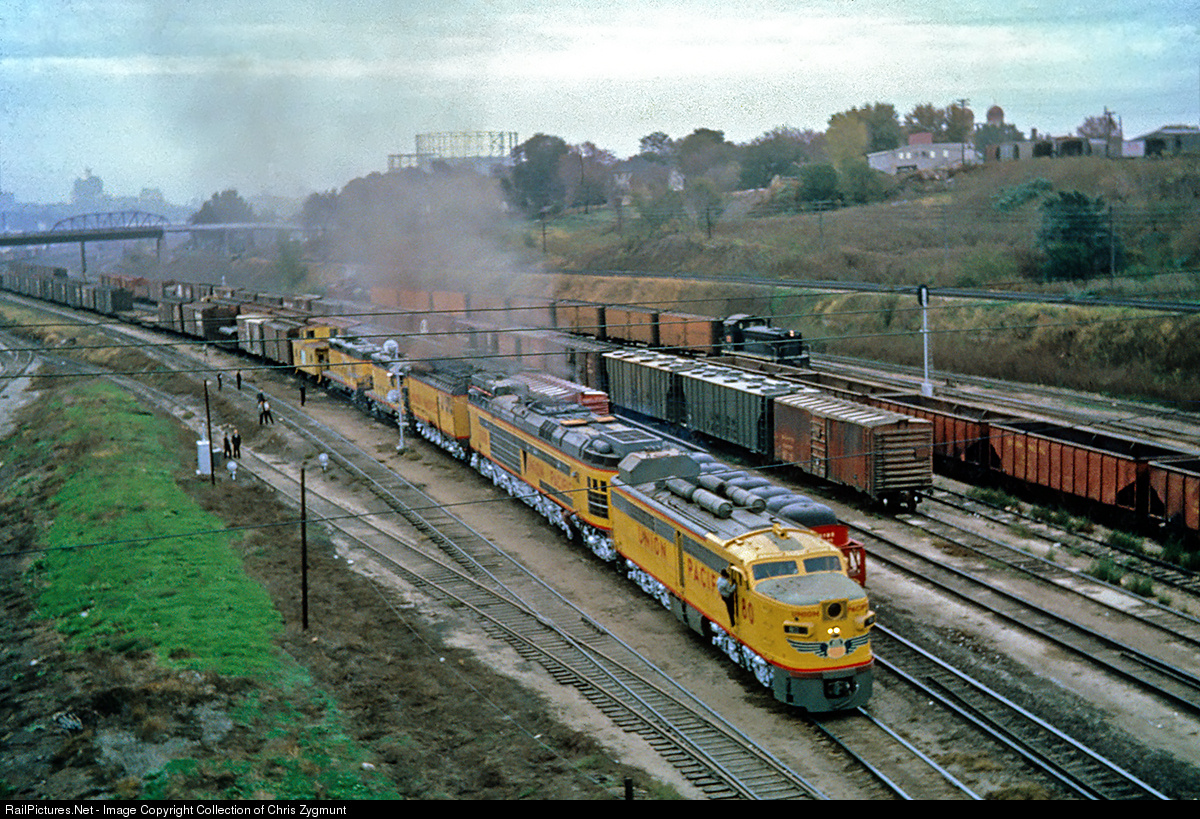
Collection of Chris Zygmunt wrote:UP's only coal turbine electric makes a test run as many officials look on. This locomotive was an experimental and didn't run very much as it was deemed a failure. A set of diesels was always in the consist for protection power. In service photos are extremely rare. Photo was taken by Jack Pfeifer.
Photo Page:
http://www.railpictures.net/viewphoto.p ... 972&nseq=9
Collection:
http://www.railpictures.net/showphotos.php?userid=68983
Omaha Skyline Photos, Omaha Aerial Photos, and More.
Website: www.bradwilliamsphotography.com
Facebook: www.facebook.com/bradwilliamsphotography
Twitter: www.twitter.com/bradwphoto
Instagram: www.instagram.com/bradwilliamsphotography
YouTube: www.youtube.com/@bradwilliamsphoto
Re: Old photos
The mighty 72nd and Dodge!
- Attachments
-
- Omaha1973_02_2000-700x464.jpg (86.55 KiB) Viewed 21763 times
-
- Omaha1973_01_2000-700x460.jpg (77.71 KiB) Viewed 21763 times

Re: Old photos
I never knew that there were railroad tracks near 72nd and Dodge at one point.
Verbum Domini Manet in Aeternum
Re: Old photos
jessep28 wrote:I never knew that there were railroad tracks near 72nd and Dodge at one point.
I was born that year. The only things I remember in those pictures is Wolf Brothers and Hinky Dinky. Of course, Wolf Brothers is still there and so is that sign.
Re: Old photos
I was going to point you to this thread, but all the links are dead.jessep28 wrote:I never knew that there were railroad tracks near 72nd and Dodge at one point.
http://www.eomahaforums.com/viewtopic.p ... wes+Photos
Yes, there was a massive Grain Elevator where Lowes is now and a rail yard next to it. The tracks ran north to Irvington where they split. One line ran to Bennington and the other turned ease and basically followed the Sorenson Parkway to North Omaha. Southbound the tracks went through Aksarben and then east and met the UP by the 80/480/JFK junction.
Omaha Skyline Photos, Omaha Aerial Photos, and More.
Website: www.bradwilliamsphotography.com
Facebook: www.facebook.com/bradwilliamsphotography
Twitter: www.twitter.com/bradwphoto
Instagram: www.instagram.com/bradwilliamsphotography
YouTube: www.youtube.com/@bradwilliamsphoto
Re: Old photos
I do not see one pothole or patched up road. The roads and sidewalks all look new. When did that change?
Re: Old photos
I saw the grain elevator in the Peony aerial linked on page two, and figured the tracks were tied in with that. I'll have to look at the old aerial photos on Google maps or Douglas County GIS to visualize the layout. I was born in the first half of the 1980's and didn't move to Omaha until 1990 when I was young, so a lot of this stuff was before my time.Brad wrote:I was going to point you to this thread, but all the links are dead.jessep28 wrote:I never knew that there were railroad tracks near 72nd and Dodge at one point.
http://www.eomahaforums.com/viewtopic.p ... wes+Photos
Yes, there was a massive Grain Elevator where Lowes is now and a rail yard next to it. The tracks ran north to Irvington where they split. One line ran to Bennington and the other turned ease and basically followed the Sorenson Parkway to North Omaha. Southbound the tracks went through Aksarben and then east and met the UP by the 80/480/JFK junction.
Verbum Domini Manet in Aeternum
Re: Old photos
It says I'm not authorized to read the forum.jessep28 wrote:I saw the grain elevator in the Peony aerial linked on page two, and figured the tracks were tied in with that. I'll have to look at the old aerial photos on Google maps or Douglas County GIS to visualize the layout. I was born in the first half of the 1980's and didn't move to Omaha until 1990 when I was young, so a lot of this stuff was before my time.Brad wrote:I was going to point you to this thread, but all the links are dead.jessep28 wrote:I never knew that there were railroad tracks near 72nd and Dodge at one point.
http://www.eomahaforums.com/viewtopic.p ... wes+Photos
Yes, there was a massive Grain Elevator where Lowes is now and a rail yard next to it. The tracks ran north to Irvington where they split. One line ran to Bennington and the other turned ease and basically followed the Sorenson Parkway to North Omaha. Southbound the tracks went through Aksarben and then east and met the UP by the 80/480/JFK junction.
Re: Old photos
I believe 32nd & L. Not sure who the kid is.
- Attachments
-
- 16104.jpeg (32.94 KiB) Viewed 21548 times
Re: Old photos
The pool should have been saved.
- Attachments
-
- 12529.jpeg (53.92 KiB) Viewed 21504 times
-
GRANDPASMUCKER
- Human Relations
- Posts: 832
- Joined: Tue Mar 11, 2014 3:10 pm
- Location: Omaha
Re: Old photos
I swam in that pool hundreds of times in the early and mid 70's. I learned to swim like a fish in that pool after awhile. What was crazy was it only cost a quarter to get in the main gate at Peony Park and another 75 cents to get in the pool. Why anyone would waste their time going to a city pool was beyond me. Sometimes when money was tight we would go up the stairs to the skyrail and jump down over the fence so we could save the 75 cents for an ice cream cone and a couple games of pinball in the arcade. Those were the days!
Re: Old photos
Plus, it had sand like a beach! Now it's a Hy-Vee. Whoop-de-doo.GRANDPASMUCKER wrote:I swam in that pool hundreds of times in the early and mid 70's. I learned to swim like a fish in that pool after awhile. What was crazy was it only cost a quarter to get in the main gate at Peony Park and another 75 cents to get in the pool. Why anyone would waste their time going to a city pool was beyond me. Sometimes when money was tight we would go up the stairs to the skyrail and jump down over the fence so we could save the 75 cents for an ice cream cone and a couple games of pinball in the arcade. Those were the days!

Re: Old photos
I only got to go there a few times. It didn't seem like a swimming pool at all, it was an inland beach.choke wrote:Plus, it had sand like a beach! Now it's a Hy-Vee. Whoop-de-doo.
I LOVED those three fountains out in the middle!
Re: Old photos
A few more old photos, more to come...
- Attachments
-
- 1975
- 1975.jpg (166.32 KiB) Viewed 21359 times
-
- 1941
- 1941.jpg (86.55 KiB) Viewed 21359 times
-
- 1950's
- omaha50's.jpg (104.64 KiB) Viewed 21359 times

Re: Old photos
Wow, I love that second one! It's sickening to see how much density has been lost over the years.
Re: Old photos
Aside from the old Woodmen building, what are the other 2 or 3 brick buildings lumped together?
When fortune smiles on something as violent and ugly as revenge, it seems proof like no other that not only does God exist, you're doing his will.
The Bride
The Bride
Re: Old photos
OH WOW!! I love the one with the old U.P. building with the WOW building behind it. I looked up this stretch of road on Google maps and found 2 interesting things:
1. 15th street doesn't go all the through anymore due to the FNBO park and
2. 15th street still curves to the west where the railroad used to be. It looks like the land is going to be a part of the Yard development.
It's so crazy to think how much things have changed. It's astounding. Thank you for posting these picutres!
Re: Old photos
There is an amazing collection of photos at landmark.cityofomaha.org. The Meyer Collection and Survey Images are packed with photos of downtown and Jobber's Canyon and lots of other pictures of the Omaha area as well. The Medical Arts building/downtown pictured here are from that collection.
- Attachments
-
- medicalarts.jpg (92.19 KiB) Viewed 21361 times
-
- downtown.jpg (135.07 KiB) Viewed 21361 times
-
- DTOld9.jpg (207.6 KiB) Viewed 21361 times
Re: Old photos
This is from the Omaha World Herald. January, 1966. 14th and Locust St.
- Attachments
-
- tumblr_n6ljezQZKZ1qfp85qo1_1280.jpg (131.67 KiB) Viewed 21360 times

Re: Old photos
Hotel Fontenelle looms
Note Tip Top to left
Note Tip Top to left
Shoot for the Moon... if you miss, you'll land among the stars.
-
Midwestern
- Home Owners Association
- Posts: 208
- Joined: Fri Feb 13, 2015 2:08 pm
Re: Old photos
It seems like we've lost a much higher percentage of our 10+ story historic buildings than other similar cities.
Sure do wish we still had the Medical Arts building, Hotel Fontenelle, and the old WOW tower. If I could choose to bring something back, I'd rather have those three than Jobbers Canyon. But the reality is all of them are gone forever.
The AT&T building sure used to be beautiful!
Sure do wish we still had the Medical Arts building, Hotel Fontenelle, and the old WOW tower. If I could choose to bring something back, I'd rather have those three than Jobbers Canyon. But the reality is all of them are gone forever.
The AT&T building sure used to be beautiful!
Re: Old photos
Love this photo!tanman wrote:This is from the Omaha World Herald. January, 1966. 14th and Locust St.
While not exactly the same location, reminds me of this photo I took back in 2006.

Omaha Skyline Photos, Omaha Aerial Photos, and More.
Website: www.bradwilliamsphotography.com
Facebook: www.facebook.com/bradwilliamsphotography
Twitter: www.twitter.com/bradwphoto
Instagram: www.instagram.com/bradwilliamsphotography
YouTube: www.youtube.com/@bradwilliamsphoto
Re: Old photos
Nice photo Brad. 
-
PotatoeEatsFish

- Human Relations
- Posts: 750
- Joined: Wed Jul 22, 2015 11:59 pm
Re: Old photos
Some developer please build a replica of the Fontenelle in the old market. That way it won't be demolished for the next hundred years.
#SaveTheUglyGrainSilos2024

Re: Old photos
I'd rather they rebuild the old WOW building in its original location and put the Fontenelle replica next to that.PotatoeEatsFish wrote:Some developer please build a replica of the Fontenelle in the old market. That way it won't be demolished for the next hundred years.
He said "They are some big, ugly red brick buildings"
...and then they were gone.
...and then they were gone.
-
Midwestern
- Home Owners Association
- Posts: 208
- Joined: Fri Feb 13, 2015 2:08 pm
Re: Old photos
Speaking of the WOW building's original location...GetUrban wrote:I'd rather they rebuild the old WOW building in its original location and put the Fontenelle replica next to that.PotatoeEatsFish wrote:Some developer please build a replica of the Fontenelle in the old market. That way it won't be demolished for the next hundred years.
If and when the state building is torn down, would they be able to preserve the underground parking portion and then re-build something on top of that? Having underground parking is a huge plus for that location. How many underground stalls do they have, does anyone know?
Would it even be possible to do a replica of the Fontenelle's crown these days? Does anyone in this country even make stuff like that anymore?
-
Joe_Sovereign
- Library Board
- Posts: 433
- Joined: Thu Sep 06, 2012 3:57 pm
- Location: Omaha Metro Area
Re: Old photos
What is the building that was torn down on Douglas Street for the Woodmen Tower Parking Garage?


Re: Old photos
The buildings on the current site of the woodman are (east to west), The Bee Newspaper building and then west, the Omaha City Hall. The "C" shaped building just north on the same block was known as the Brandeis Theater (bldg) ...in my memory...as there was an earlier, Orpheum like (size & layout) live theater in the center of the "C", practically invisible in this view. The rest of the building had the typical office space/living units, etc, of many of the buildings of that era.Joe_Sovereign wrote:What is the building that was torn down on Douglas Street for the Woodmen Tower Parking Garage?
Re: Old photos
The Golden Spike! Huber Chevrolet now occupies this site.
- Attachments
-
- gold.JPG (215.45 KiB) Viewed 21009 times
Re: Old photos
Gay nineties? 
Re: Old photos
This ad was probably from the 1950's. There were likely still a few people around who remembered the 1890's as some kind of "golden era". At one time, there were names for certain decades: Gay 90's, Roaring 20's, Fabulous 50's, Swinging 60's. "Gay" had a different meaning back then. BTW, I remember getting in trouble for attending an all-night Clint Eastwood movie marathon at this drive-in around the early 70's.daveoma wrote:Gay nineties?
-
Coyote

- City Council
- Posts: 33290
- Joined: Tue Nov 18, 2003 11:18 am
- Location: Aksarben Village
- Contact:
Re: Old photos
Omaha: 1960
What do you see?
What do you see?
- image.jpg (255.54 KiB) Viewed 19956 times

Re: Old photos
Is that Crossroads?
Re: Old photos
Lewis and Clark Jr. High in the upper left, the Omaha Playhose upper center, the big grain elevator where NFM warehouse is (Mrs. B was still downtown), and "little boxes made of ticky tacky". Also, there was a drive in movie theater in the flats below Sears. My folks took us to a couple of movies there, but I usually fell asleep in the back of the station wagon.
"Prediction is very difficult, especially about the future." -- Niels Bohr
-
skinzfan23

- City Council
- Posts: 9256
- Joined: Mon Feb 09, 2004 11:26 am
- Location: Omaha/Bellevue
Re: Old photos
Amazing how that area has changed.
Re: Old photos
District 66 when it was new.
That's Broadmoor drive entering in half way up the left side and it runs over to the green-space that adjoins Swanson Elementary.
You can also see Christ the King right on the right edge, so Countryside Village is just out of frame to the right.
That's south 91st circle at the bottom which makes the street with the white car 90th back when it was only 2 lanes.
Back in High-school, I accidentally had my VW bug up on two wheels raking that curve on Broadmoor. Going too fast and hit some wet leaves. Scares the |expletive| out of us!
Omaha Skyline Photos, Omaha Aerial Photos, and More.
Website: www.bradwilliamsphotography.com
Facebook: www.facebook.com/bradwilliamsphotography
Twitter: www.twitter.com/bradwphoto
Instagram: www.instagram.com/bradwilliamsphotography
YouTube: www.youtube.com/@bradwilliamsphoto
-
nebugeater

- City Council
- Posts: 108967
- Joined: Wed Aug 04, 2004 6:07 pm
- Location: Gretna NE
Re: Old photos
Anyone on here latched on to the Facebook group... Forgotten Omaha
https://www.facebook.com/groups/9763096 ... 3/?fref=nf
https://www.facebook.com/groups/9763096 ... 3/?fref=nf
For the record NEBUGEATER does not equal BUGEATER !!!!!!!