Hey guys, I had some questions that hopefully you all can answer for me. I've been playing around with GoogleMap Street View and Live Search Maps (thanks again, Bradley!) and looking for places I remember from when I lived there...which believe me, can be torture when you're dying to get back...and I had these questions.
First, I remember that there was a Baker's on 72nd that we used to go to sometimes when I was a kid. If I remember correctly, it was a brick building and was rebuilt after being destroyed in the 75 tornado. I seem to remember it being south of Dodge, but I'm not sure on that. Is that Baker's still open or did it get closed?
Next, I see that there is now a Home Depot on the northeast corner of 72nd and Ames. Is that the same building that used to be the KMart and then housed the Oriental Trading Company? Also while we're talking about Ames, wasn't there a hospital at one time on the north side of the street? It might have been torn down before we left but I remember that there was a tornado siren located at this site.
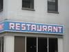
One last question about Ames. In the same general area as the hospital was a restaurant that I always wanted to go to but never got the chances. It was on the north side of the street and the sign had a cartoon character fish or frog, can't remember which. I'm pretty sure it was a popular restaurant but I don't remember the name so I can't look to see if it's around anymore.
Thanks everyone!
Things that have changed since I left Omaha
Moderators: Coyote, nebugeater, Brad, Omaha Cowboy, BRoss
-
Bosco55David

- Parks & Recreation
- Posts: 1396
- Joined: Wed Oct 22, 2008 1:25 am
- Location: Tampa, FL (formerly Omaha and Council Bluffs)
-
Coyote

- City Council
- Posts: 33201
- Joined: Tue Nov 18, 2003 11:18 am
- Location: Aksarben Village
- Contact:
That area of Omaha is not one of my best remembered from back in the day - but - I believe you may be thinking of Immanuel Hospital which is a little further north on 72nd St. but I cannot think of a single restaurant that would have been in that area back then. But again - my recollection of that are only includes an Ames A&W that had the world's best Root Beer.

The Bakers on 72nd street that was hit by the '75 tornado was at 72nd & Blondo. It closed a few years ago after Bakers sold their stores, but never reopened and remains vacant today. I wish someone would develop that eyesore of a building.
I believe there was also a Bakers on the NE corner of 72nd & Dodge and a Safeway just east of that on Dodge. Later they became Petco and Family Fun Center, respectively. They were also hit by the tornado but not totaled like the Dowtowner Travel Lodge motel on Dodge a little further east, which was never rebuilt.
I don't recall if there were any Bakers further south on 72nd that may have been hit.
I stumbled across this website that has some good info about the '75 tornado, if you're interested. http://www.shayden.com/_Omaha5675/News&Articles.htm
The Home Depot at 72nd and Ames is new and was built when they completely re-aligned the 72nd - Ames - Military intersection. I remember that K-Mart though...it had a huge sea of asphalt in front of it, much like Home Depot does today.
The Hospital you are referring to must be Immanuel Hospital which is further north by 72nd and Redick. I can't recall any restaurants meeting your description...sound like a fun place!
By the way, this is my first post to this site. I've enjoyed lurking and reading it for a couple of months now, and look forward to contributing/commenting where I can.
Cheers!
Last edited by GetUrban on Sun Nov 23, 2008 3:46 pm, edited 1 time in total.

Thanks for the welcome! Â It's a great site for all things Omaha. Â I love to see so many people who are enthusiastic about seeing Omaha become a better, more progressive, urban place to live.Admin wrote:Welcome to eOmahaForums GetUrban, I hope you do contribute again. Great remembrances of 1975 Omaha!
BTW - you are member 1000!
What do I WIN for becoming Member #1000 ? Â :-)
-
Bosco55David
- Parks & Recreation
- Posts: 1396
- Joined: Wed Oct 22, 2008 1:25 am
- Location: Tampa, FL (formerly Omaha and Council Bluffs)
That's the one! My memory betrayed me though, as I was picturing a small "strip mall" in the same lot. Â :oGetUrban wrote:The Bakers on 72nd street that was hit by the '75 tornado was at 72nd & Blondo. It closed a few years ago after Bakers sold their stores, but never reopened and remains vacant today. I wish someone would develop that eyesore of a building.
Interesting little tidbit. My dad got caught at that intersection when the tornado came through. He had just dropped my mom off at work and was driving on 72nd when it hit. A telephone or power line pole ended up falling on the hood of his car so he took shelter in one of the gas station tire racks across the street. He told me that he watched the tornado come and that the Baker's actually imploded right before the tornado reached it.
Ahhh yes, the Family Fun Center. Got alot of fun memories there. Â :DI believe there was also a Bakers on the NE corner of 72nd & Dodge and a Safeway just east of that on Dodge. Later they became Petco and Family Fun Center, respectively. They were also hit by the tornado but not totaled like the Dowtowner Travel Lodge motel on Dodge a little further east, which was never rebuilt.
So they tore down that building and started fresh? Can you elaborate on the realignment? I had absolutely no clue that anything like that had happened!The Home Depot at 72nd and Ames is new and was built when they completely re-aligned the 72nd - Ames - Military intersection. I remember that K-Mart though...it had a huge sea of asphalt in front of it, much like Home Depot does today.
It's not Immanuel. This one was right there on the north side of Ames, kind of on a hill. My mom doesn't remember what it was called, but she says it was fairly small, never did too well and was closed before we moved to Council Bluffs, which was 96...so it was probably torn down a short time after that. The tricky part is that it wasn't very visible from Ames with the tree line there, but there was a small set of stairs right off the sidewalk on Ames. I think that small set of stairs had a cover over it too, but the walkway leading up to the hospital didn't. I'd like to know the logic behind that, lmao.The Hospital you are referring to must be Immanuel Hospital which is further north by 72nd and Redick. I can't recall any restaurants meeting your description...sound like a fun place!
Well thank you very much for the information and welcome to the site! I'm a relative newbie too but everyone here has been great. Very helpful people here. [/quote]By the way, this is my first post to this site. I've enjoyed lurking and reading it for a couple of months now, and look forward to contributing/commenting where I can.
Cheers!
-
Bosco55David
- Parks & Recreation
- Posts: 1396
- Joined: Wed Oct 22, 2008 1:25 am
- Location: Tampa, FL (formerly Omaha and Council Bluffs)

Careful. Â Some of us are raging alcoholics with expensive tastes.Bosco55David wrote:I'll get in on that action. With all the help I've gotten from our members, I'll be glad to buy to a round or two!Admin wrote:How about a draft at our next eOmahaForums meet and greet. :cheers:
Or is that just me?
Stable genius.
Ames, 72nd, & Military used to all come together into an awkward 3-way intersection. Ames used to curve further south more directly into 72nd. That's the way you probably remember it.Bosco55David wrote:So they tore down that building and started fresh? Can you elaborate on the realignment? I had absolutely no clue that anything like that had happened!The Home Depot at 72nd and Ames is new and was built when they completely re-aligned the 72nd - Ames - Military intersection. I remember that K-Mart though...it had a huge sea of asphalt in front of it, much like Home Depot does today.
In the late 90's (I think that's when it was done) they reconfigured the whole intersection, tearing down the old K-Mart in the process, creating new areas for retail development, where we now have Home Depot, Ihop, McDonalds, Arby's, Hancock Fabrics, and south of Ames are Famous Daves, Bakers, Block Buster, Sonic, PepperJax Grill, etc.
Ames now intersects 72nd at 90 degrees further north of the Military/72nd intersection. It was a major improvement for traffic flow in the area and was the catalyst for alot of new development, which was badly needed in the neighborhood.
I tried to find some "before and after" aerial pictures of the intersections, with no luck. It would be easier to explain with a side by side comparison. Â I'll keep looking :-)
Oh, and now I remember It was a Hinky Dinky at 72nd & Dodge next to the Safeway, not another Bakers.
Big E wrote:Careful. Some of us are raging alcoholics with expensive tastes.Bosco55David wrote:I'll get in on that action. With all the help I've gotten from our members, I'll be glad to buy to a round or two!Admin wrote:How about a draft at our next eOmahaForums meet and greet. :cheers:
Or is that just me?
Count me in!
-
Bosco55David
- Parks & Recreation
- Posts: 1396
- Joined: Wed Oct 22, 2008 1:25 am
- Location: Tampa, FL (formerly Omaha and Council Bluffs)
Ahh yes, now I see what you are saying! Thanks for the clarification. I checked the aerial photos on Live Search and can see exactly what you're talking about now. That intersection is completely different than I remember.GetUrban wrote:Ames, 72nd, & Military used to all come together into an awkward 3-way intersection. Ames used to curve further south more directly into 72nd. That's the way you probably remember it.Bosco55David wrote:So they tore down that building and started fresh? Can you elaborate on the realignment? I had absolutely no clue that anything like that had happened!The Home Depot at 72nd and Ames is new and was built when they completely re-aligned the 72nd - Ames - Military intersection. I remember that K-Mart though...it had a huge sea of asphalt in front of it, much like Home Depot does today.
In the late 90's (I think that's when it was done) they reconfigured the whole intersection, tearing down the old K-Mart in the process, creating new areas for retail development, where we now have Home Depot, Ihop, McDonalds, Arby's, Hancock Fabrics, and south of Ames are Famous Daves, Bakers, Block Buster, Sonic, PepperJax Grill, etc.
Ames now intersects 72nd at 90 degrees further north of the Military/72nd intersection. It was a major improvement for traffic flow in the area and was the catalyst for alot of new development, which was badly needed in the neighborhood.
I tried to find some "before and after" aerial pictures of the intersections, with no luck. It would be easier to explain with a side by side comparison. I'll keep looking :-)
Oh, and now I remember It was a Hinky Dinky at 72nd & Dodge next to the Safeway, not another Bakers.
I think that probably happened in the early 2000's. We moved to Florida in early 2002 and I don't remember that project happening...but then again, as we witnessed with the Baker's thing, my memory is suspect at best. Â :?
-
Bosco55David
- Parks & Recreation
- Posts: 1396
- Joined: Wed Oct 22, 2008 1:25 am
- Location: Tampa, FL (formerly Omaha and Council Bluffs)
What do you drink? I'm pretty fond of Jager Bombs, Washington Apples and Rum n' Coke myself. If we're talking beers, Corona, Sam Adams, Rolling Rock and Land Shark are my weapons of choice. Â :mrgreen:GetUrban wrote:Big E wrote:Careful. Some of us are raging alcoholics with expensive tastes.Bosco55David wrote:I'll get in on that action. With all the help I've gotten from our members, I'll be glad to buy to a round or two!Admin wrote:How about a draft at our next eOmahaForums meet and greet. :cheers:
Or is that just me?
Count me in!
-
dandr1229
- New to the Neighborhood
- Posts: 36
- Joined: Mon Jun 16, 2008 12:14 pm
- Location: Omaha Metro Area
Re: Things that have changed since I left Omaha
A restraunt or a bar? Â Â A cartoon character sign at that location reminds me of Tiger Tom's Pub.Bosco55David wrote:One last question about Ames. In the same general area as the hospital was a restaurant that I always wanted to go to but never got the chances. It was on the north side of the street and the sign had a cartoon character fish or frog, can't remember which. I'm pretty sure it was a popular restaurant but I don't remember the name so I can't look to see if it's around anymore.
Thanks everyone!
Ditto.Big E wrote:Careful. Some of us are raging alcoholics with expensive tastes.Bosco55David wrote:I'll get in on that action. With all the help I've gotten from our members, I'll be glad to buy to a round or two!Admin wrote:How about a draft at our next eOmahaForums meet and greet. :cheers:
Or is that just me?
DTO
Re: Things that have changed since I left Omaha
Which moved a few years ago from the west side of 72nd just north of military to the south side of military just east of 72nd.dandr1229 wrote:
A restraunt or a bar? A cartoon character sign at that location reminds me of Tiger Tom's Pub.
-
Bosco55David
- Parks & Recreation
- Posts: 1396
- Joined: Wed Oct 22, 2008 1:25 am
- Location: Tampa, FL (formerly Omaha and Council Bluffs)
What's the building here on the corner of 66th and Ames? That looks sort of like the building I'm talking about.
http://maps.live.com/?mkt=en-us#JnE9eXA ... c3ODkxOQ==
http://maps.live.com/?mkt=en-us#JnE9eXA ... c3ODkxOQ==

Back in the day it was a Joe Tess restaurant.Bosco55David wrote:What's the building here on the corner of 66th and Ames? That looks sort of like the building I'm talking about.

Omaha Skyline Photos, Omaha Aerial Photos, and More.
Website: www.bradwilliamsphotography.com
Facebook: www.facebook.com/bradwilliamsphotography
Twitter: www.twitter.com/bradwphoto
Instagram: www.instagram.com/bradwilliamsphotography
YouTube: www.youtube.com/@bradwilliamsphoto
Bosco55David wrote:What's the building here on the corner of 66th and Ames? That looks sort of like the building I'm talking about.
http://maps.live.com/?mkt=en-us#JnE9eXA ... c3ODkxOQ==
Not sure what that is....I'll have to do a drive-by and report back. I seem to remember some sort of large 60's style night club in the area on the south side of Ames.
BTW....here's a link to an EOmahaforums thread about that Benson Park Plaza area:
http://eomahaforums.com/phpBB/viewtopic.php?t=4434
They finished building the new Steve & Barry's clothing store north of Home Depot, but the chain went bankrupt before they ever opened. The new never-occupied building sits vacant now. :-(
-
Bosco55David
- Parks & Recreation
- Posts: 1396
- Joined: Wed Oct 22, 2008 1:25 am
- Location: Tampa, FL (formerly Omaha and Council Bluffs)
Back in the day, they had to locations.
Omaha Skyline Photos, Omaha Aerial Photos, and More.
Website: www.bradwilliamsphotography.com
Facebook: www.facebook.com/bradwilliamsphotography
Twitter: www.twitter.com/bradwphoto
Instagram: www.instagram.com/bradwilliamsphotography
YouTube: www.youtube.com/@bradwilliamsphoto
-
UNOstudent
- Human Relations
- Posts: 584
- Joined: Sun Nov 07, 2004 10:27 pm
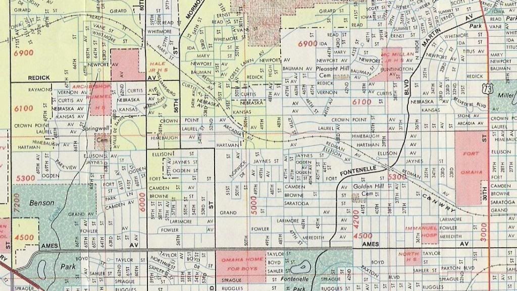
Here is a scan of a Standard Oil 1973-74 map of Omaha.
1. Immanuel Hospital used to be on 36th St, just north of Ames. If you look at Google Maps, it now shows about two dozen houses in its place. From the assessor's page, they were all built in 1992. The parcel just north of the old hostpital is a nursing home built in 1950. Â
2. The old Chicago and Northwestern Railroad tracks are seen where present day Sorensen Parkway is. However the tracks did go further north between 56th and 72nd (behind the current Immanuel Hospital) than does Sorensen Parkway. Also, the small railroad you see at the bottom right was part of the Omaha Belt Line which was owned by Missouri Pacific Railroad.
3. Intersection of 72nd and Ames with Ames turning SW to intersect with 72nd and Military.
4. North 30th St was Highway 73. Before I-29, Highway 73/75 was Fort Crook Road in Bellevue, 13th St in Omaha, then split downtown. Highway 75 crossed into Iowa with Highway 6 then turned north. Highway 73 followed 30th St north through Blair.
5. Another old road map I have shows a school at the NW corner of 32nd and Ames. It must have been torn down in the 80s or 90s, as today it is Meredith Manor housing and was built in 2000.
-
Bosco55David
- Parks & Recreation
- Posts: 1396
- Joined: Wed Oct 22, 2008 1:25 am
- Location: Tampa, FL (formerly Omaha and Council Bluffs)
Thanks for the info and the map! The 36th and Ames area looks like the piece of land I remember.UNOstudent wrote:Here is a scan of a Standard Oil 1973-74 map of Omaha.
1. Immanuel Hospital used to be on 36th St, just north of Ames. If you look at Google Maps, it now shows about two dozen houses in its place. From the assessor's page, they were all built in 1992. The parcel just north of the old hostpital is a nursing home built in 1950.
2. The old Chicago and Northwestern Railroad tracks are seen where present day Sorensen Parkway is. However the tracks did go further north between 56th and 72nd (behind the current Immanuel Hospital) than does Sorensen Parkway. Also, the small railroad you see at the bottom right was part of the Omaha Belt Line which was owned by Missouri Pacific Railroad.
3. Intersection of 72nd and Ames with Ames turning SW to intersect with 72nd and Military.
4. North 30th St was Highway 73. Before I-29, Highway 73/75 was Fort Crook Road in Bellevue, 13th St in Omaha, then split downtown. Highway 75 crossed into Iowa with Highway 6 then turned north. Highway 73 followed 30th St north through Blair.
5. Another old road map I have shows a school at the NW corner of 32nd and Ames. It must have been torn down in the 80s or 90s, as today it is Meredith Manor housing and was built in 2000.
-
Bosco55David
- Parks & Recreation
- Posts: 1396
- Joined: Wed Oct 22, 2008 1:25 am
- Location: Tampa, FL (formerly Omaha and Council Bluffs)
-
UNOstudent2
For whatever reason I cannot login again. When I enter my username and password the screen just goes blank.Bosco55David wrote:That's awesome UNO! Thanks again!
Where do you find those pictures at?
For one of my classes I took a recent aerial image and used it as an underlay for an older aerial image. I took an old photo of the area covering 80/480/JFK before the interstate and laid it over a current image. It gives you a good idea to see what was removed when the interstate was constructed.
Anyways, the website is: h t t p : / / d n r d a t a . d n r . n e . g o v / C O Q I n t e r f a c e /
At this website you can enter the county, click submit, click view for the part of the county you want to view, then select the year and quadrant of that area, then click the top link to get the picture.
So for the old image of 72nd and Ames, I selected: Douglas, Irvington, SE 1999 Mercator, then the .jpg link.
h t t p : / / w w w . d n r . n e . g o v / C o q A r e a / c o q 9 9 / c o q u t m / 4 1 _ 0 9 6 / 4 1 0 9 6 4 8 S E . j p g
---When you copy and paste the link, make sure you delete the spaces
-
Bosco55David
- Parks & Recreation
- Posts: 1396
- Joined: Wed Oct 22, 2008 1:25 am
- Location: Tampa, FL (formerly Omaha and Council Bluffs)
Thanks for posting...Good info!UNOstudent2 wrote:For whatever reason I cannot login again. When I enter my username and password the screen just goes blank.Bosco55David wrote:That's awesome UNO! Thanks again!
Where do you find those pictures at?
For one of my classes I took a recent aerial image and used it as an underlay for an older aerial image. I took an old photo of the area covering 80/480/JFK before the interstate and laid it over a current image. It gives you a good idea to see what was removed when the interstate was constructed.
Anyways, the website is: h t t p : / / d n r d a t a . d n r . n e . g o v / C O Q I n t e r f a c e /
At this website you can enter the county, click submit, click view for the part of the county you want to view, then select the year and quadrant of that area, then click the top link to get the picture.
So for the old image of 72nd and Ames, I selected: Douglas, Irvington, SE 1999 Mercator, then the .jpg link.
h t t p : / / w w w . d n r . n e . g o v / C o q A r e a / c o q 9 9 / c o q u t m / 4 1 _ 0 9 6 / 4 1 0 9 6 4 8 S E . j p g
---When you copy and paste the link, make sure you delete the spaces
-
nativeomahan

- County Board
- Posts: 5362
- Joined: Fri Nov 12, 2004 2:46 pm
- Location: Omaha and Puerto Vallarta
The old Nasr's. Â Later it became Cartier's and had lots of problems with clientele. Â It was Cleopatra's in between. Â A supper club type atmosphere. Â I saw Lou Rawls in concert there in the 1980s. Â He was awesome.Bosco55David wrote:What's the building here on the corner of 66th and Ames? That looks sort of like the building I'm talking about.
http://maps.live.com/?mkt=en-us#JnE9eXA ... c3ODkxOQ==
-
UNOstudent
- Human Relations
- Posts: 584
- Joined: Sun Nov 07, 2004 10:27 pm
Map Viewer for Nebraska. You can zoom in/out over Omaha or wherever. In Omaha, they have aerial pictures of 1993, 1999, 2003, 2006, 2007. Also, you can add an elevation layer with 10 foot contour lines, etc.
http://dnrmap2.dnr.state.ne.us/website/ ... viewer.htm
http://dnrmap2.dnr.state.ne.us/website/ ... viewer.htm
-
Bosco55David
- Parks & Recreation
- Posts: 1396
- Joined: Wed Oct 22, 2008 1:25 am
- Location: Tampa, FL (formerly Omaha and Council Bluffs)
-
Bosco55David
- Parks & Recreation
- Posts: 1396
- Joined: Wed Oct 22, 2008 1:25 am
- Location: Tampa, FL (formerly Omaha and Council Bluffs)
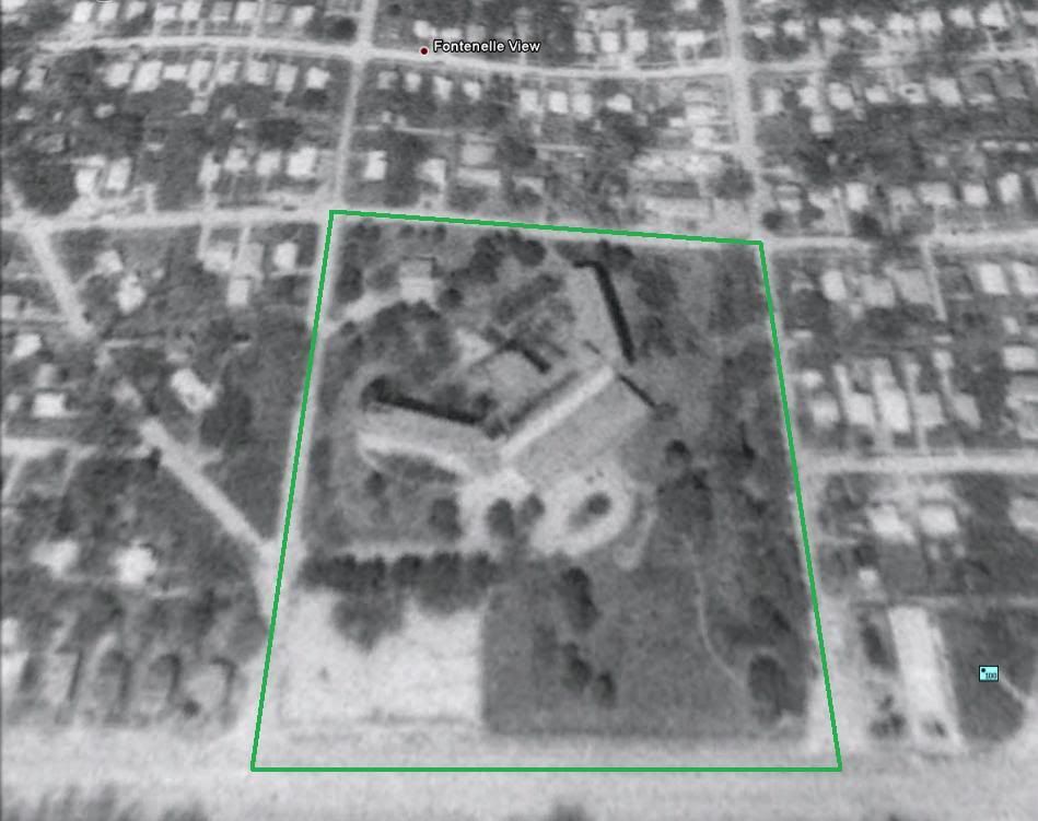
Bosco55David wrote:Also while we're talking about Ames, wasn't there a hospital at one time on the north side of the street? It might have been torn down before we left but I remember that there was a tornado siren located at this site.
GetUrban wrote:The Hospital you are referring to must be Immanuel Hospital which is further north by 72nd and Redick.
So, I'm about 99% certain I found this "hospital" I was looking for, however it doesn't look like a hospital to me. Maybe someone here can tell me what it was.Bosco55David wrote:It's not Immanuel. This one was right there on the north side of Ames, kind of on a hill. My mom doesn't remember what it was called, but she says it was fairly small, never did too well and was closed before we moved to Council Bluffs, which was 96...so it was probably torn down a short time after that. The tricky part is that it wasn't very visible from Ames with the tree line there, but there was a small set of stairs right off the sidewalk on Ames. I think that small set of stairs had a cover over it too, but the walkway leading up to the hospital didn't. I'd like to know the logic behind that
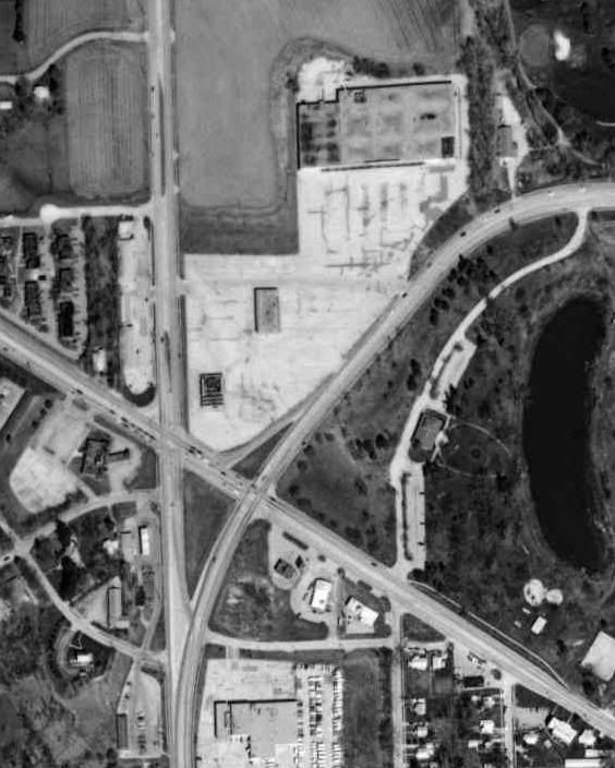
Here it is in 1993. The streets bordering this plot of land are 45th and 46th Streets, and then Ames and Fowler Avenues.
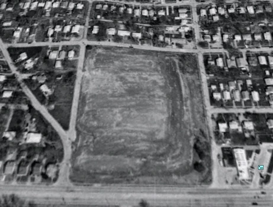
In 1999, the building has been demolished and the land almost completely cleared.
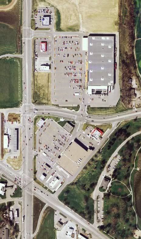
Present day, with houses.
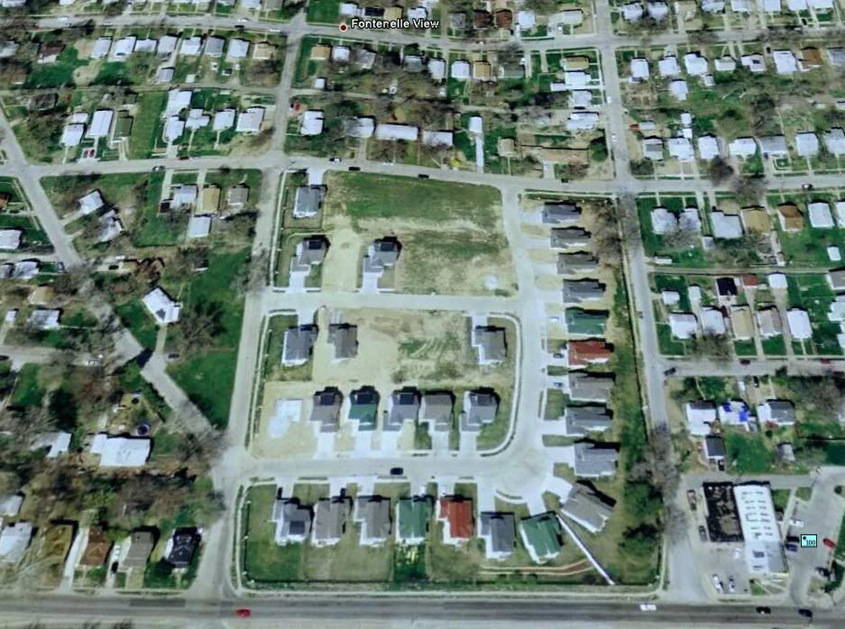
I have been in that neighborhood. Its right across from the golf course and looks like a typical suburban neighborhood. Â I think I put a bid in on it when I worked at the Lawn Service about 7 years ago.
Omaha Skyline Photos, Omaha Aerial Photos, and More.
Website: www.bradwilliamsphotography.com
Facebook: www.facebook.com/bradwilliamsphotography
Twitter: www.twitter.com/bradwphoto
Instagram: www.instagram.com/bradwilliamsphotography
YouTube: www.youtube.com/@bradwilliamsphoto
I'm pretty sure that Immanuel Hospital was - at one time - located just north of North High School, on 36th Street. Â Right by 36th & Larimore.
Unless it has changed in the last year, there is now an "alternative school" that is there.
Was it a different hospital right north of Ames, between 45th & 46th?
Unless it has changed in the last year, there is now an "alternative school" that is there.
Was it a different hospital right north of Ames, between 45th & 46th?
Currently, that is a Dialysis Center on the north side of Ames. DaVita Dialysis is the name, I think.Bosco55David wrote:What's the building here on the corner of 66th and Ames? That looks sort of like the building I'm talking about.
http://maps.live.com/?mkt=en-us#JnE9eXA ... c3ODkxOQ==
On the south side - on the corner - is a Chinese Restaurant. Â Beside it, to the east, is a sort of Supper Club/Keno place.
-
Bosco55David
- Parks & Recreation
- Posts: 1396
- Joined: Wed Oct 22, 2008 1:25 am
- Location: Tampa, FL (formerly Omaha and Council Bluffs)
If it was not for the lack of parking I'd say that is where Walgreen's was before they moved to the East. Â The YMCA built a new facility on 35th, not sure if that was a new or relocation. Â It does not look like it could have been that either though.Bosco55David wrote: That's what I thought it was, but now I don't know. That's the plot of land I highlighted in the first picture and it looks a little small to be a hospital.
-
nativeomahan
- County Board
- Posts: 5362
- Joined: Fri Nov 12, 2004 2:46 pm
- Location: Omaha and Puerto Vallarta
-
Guest
Things that have changed? Â Just about everything.
(ahem) Let's get in the 'way back' machine and go back to 1972.
Downtown Omaha: Thousands of people shopping, going out, going to movies, restaurants, etc.. Old Market full of hippies doing whatever hippies did---Jobbers Canyon looming to the East. Â City busses packed full of people during rush hour. Â 16th St. packed with street life---during Christmas it was like Time Square. Â South Omaha (S.24th) was Omaha's second downtown---packed on the weekends. Â 72nd St. was Omaha's gleaming "Strip". Â Peony Park was the ultimate Summer hang-out for all-ages. Â Aksarben was one of the nicest horse-racing tracks in the nation---the colosseum had public ice-skating and curling lanes (downstairs). Â Roller-skating rinks were all the rage back then, as were gas guzzling muscle-cars (I took driver's ed as a 15-year old in a Pontiac Super Bee). Â Bowling alleys had nice restaurants attached to them. Â Boy's Town was way out in the country. Â The zoo was crappy. Â Papillion was a country town. Â People would go to Eppley and Offutt to watch the jets take off. Â The Missouri River reeealy stank. Â Air and water pollution were real problems. Â Lots of racial tension. Â Older cousins coming back from Vietnam all messed-up. Â Rock music didn't suck. Â People read newspapers. Â Independent bookstores were the standard. People walking and kids riding their bikes everywhere. Â Kids made their own fun (pick-up games in the parks---without a permit!); their lives weren't scheduled down to the minute. Â Kids climbing trees (god forbid). Kids walking to school. Kids roller-skating on the sidewalks. Tree houses in the back yard. In the late 60's, Dutch Elm disease killed off Omaha's tallest and most majestic trees---most of them were gone by the early 70's----entire streets in Omaha had green tunnels formed by towering Elm trees.
Would I want to go back to that era? Â Nope. All things considered, I think Omaha's a better place now---much more diverse and inclusive, although I do think we should start planting the new disease resistant strain of Elm trees.