2018 Severe Weather Thread
-
Busguy2010

- City Council
- Posts: 7322
- Joined: Sat Apr 09, 2011 7:32 pm
- Location: North Central Omaha
Re: 2018 Severe Weather Thread
Turned out not so bad for us. They correctly predicted the stronger storms to be west of here.
-
Omaha Cowboy

- The Don
- Posts: 1013711
- Joined: Wed Jan 07, 2004 5:31 am
- Location: West Omaha
Re: 2018 Severe Weather Thread
Those Tornadoes that popped up in central Iowa yesterday (Thursday) afternoon were certainly a surprise. Thankfully, no one lost their lives. I saw some close up video footage of several of those tornadoes on the KETV 7 web site. That was a crazy situation...Busguy2010 wrote: Thu Jul 19, 2018 2:33 am Turned out not so bad for us. They correctly predicted the stronger storms to be west of here.
Ciao..LiO...Peace
Go Cowboys!
-
Busguy2010
- City Council
- Posts: 7322
- Joined: Sat Apr 09, 2011 7:32 pm
- Location: North Central Omaha
Re: 2018 Severe Weather Thread
I honestly didn't know it was that bad over there.Omaha Cowboy wrote: Fri Jul 20, 2018 1:42 pm Those Tornadoes that popped up in central Iowa yesterday (Thursday) afternoon were certainly a surprise. Thankfully, no one lost their lives. I saw some close up video footage of several of those tornadoes on the KETV 7 web site. That was a crazy situation...
Ciao..LiO...Peace
Tell me if its just me, but has this stretch of mid 80's weather felt like a departure from recent trends for July. I just feel like at least since 2011, Julys have been so sweltering, I don't remember a July with this long of a sub 90 stretch... But man is it welcome.
Edit: Well, I guess I should have checked the history. Starting on July 16th, it was below 90, but yesterday popped in at 90, although that could be because the airport is hotter. Anyway, if you leave yesterday out of it, this is a pretty long stretch. According to the forecast, we aren't expecting 90's any time soon, so a pretty much guaranteed 11 day stretch of 90 or below, with that streak possible to extend beyond that. Just feels oddly comfortable compared to the rest of the decade.
-
Omaha Cowboy
- The Don
- Posts: 1013711
- Joined: Wed Jan 07, 2004 5:31 am
- Location: West Omaha
Re: 2018 Severe Weather Thread
Compared to last year at this time, it’s a lot more comfortable. We were in the middle of a mid-late July heatwave of upper 90’s to 100’s in 2017..Busguy2010 wrote: Fri Jul 20, 2018 6:05 pmI honestly didn't know it was that bad over there.Omaha Cowboy wrote: Fri Jul 20, 2018 1:42 pm Those Tornadoes that popped up in central Iowa yesterday (Thursday) afternoon were certainly a surprise. Thankfully, no one lost their lives. I saw some close up video footage of several of those tornadoes on the KETV 7 web site. That was a crazy situation...
Ciao..LiO...Peace
Tell me if its just me, but has this stretch of mid 80's weather felt like a departure from recent trends for July. I just feel like at least since 2011, Julys have been so sweltering, I don't remember a July with this long of a sub 90 stretch... But man is it welcome.
Edit: Well, I guess I should have checked the history. Starting on July 16th, it was below 90, but yesterday popped in at 90, although that could be because the airport is hotter. Anyway, if you leave yesterday out of it, this is a pretty long stretch. According to the forecast, we aren't expecting 90's any time soon, so a pretty much guaranteed 11 day stretch of 90 or below, with that streak possible to extend beyond that. Just feels oddly comfortable compared to the rest of the decade.
I just looked at the forecast through next Friday, and the mid 80’s are perfectly fine by me
 ...
...Ciao..LiO...Peace
Go Cowboys!
-
Busguy2010
- City Council
- Posts: 7322
- Joined: Sat Apr 09, 2011 7:32 pm
- Location: North Central Omaha
Re: 2018 Severe Weather Thread
Looking like a good chance for more storms late Friday night through Saturday morning. Too bad they're going to be so late... But I've been highly impressed with this July. Cooler than I expected and more rain than I expected, though on record, were behind by almost 1.5" (though that's debatable depending what part of town you're in. Eppley has dodged a good amount of rain this month)
I'm still waiting for a really good lightning storm. I haven't had anything close to impressive yet.
I'm still waiting for a really good lightning storm. I haven't had anything close to impressive yet.
-
Busguy2010
- City Council
- Posts: 7322
- Joined: Sat Apr 09, 2011 7:32 pm
- Location: North Central Omaha
Re: 2018 Severe Weather Thread
That stretch was nice. It only reached 90 twice in a 19 day stretch, and that streak ended today. Even still, the upcoming forecast looks to continue comfortable temperatures, save a couple outlying days. I think this generally cool stretch will continue through the end of summer and it'll be a smooth transition into fall. I even think fall weather will come earlier and we may even have an early freeze.Busguy2010 wrote: Fri Jul 20, 2018 6:05 pm Tell me if its just me, but has this stretch of mid 80's weather felt like a departure from recent trends for July. I just feel like at least since 2011, Julys have been so sweltering, I don't remember a July with this long of a sub 90 stretch... But man is it welcome.
Edit: Well, I guess I should have checked the history. Starting on July 16th, it was below 90, but yesterday popped in at 90, although that could be because the airport is hotter. Anyway, if you leave yesterday out of it, this is a pretty long stretch. According to the forecast, we aren't expecting 90's any time soon, so a pretty much guaranteed 11 day stretch of 90 or below, with that streak possible to extend beyond that. Just feels oddly comfortable compared to the rest of the decade.
-
Busguy2010
- City Council
- Posts: 7322
- Joined: Sat Apr 09, 2011 7:32 pm
- Location: North Central Omaha
Re: 2018 Severe Weather Thread
Slight risk tonight. The focus area is almost, almost smack dab on Omaha, but probably a little north of here. Any other information?
-
Omaha Cowboy
- The Don
- Posts: 1013711
- Joined: Wed Jan 07, 2004 5:31 am
- Location: West Omaha
Re: 2018 Severe Weather Thread
What I’ve heard, is that if the Omaha area gets storms tonight, high wind speeds will be the greatest risk factor. No tornadic activity..Busguy2010 wrote: Sun Aug 05, 2018 4:15 pm Slight risk tonight. The focus area is almost, almost smack dab on Omaha, but probably a little north of here. Any other information?
I’ll be watching the news at 10pm for the update (KETV 7)...
Ciao..LiO...Peace
Go Cowboys!
-
Busguy2010
- City Council
- Posts: 7322
- Joined: Sat Apr 09, 2011 7:32 pm
- Location: North Central Omaha
Re: 2018 Severe Weather Thread
So it looks like this week is our first taste of fall. Potentially 1-2" of rain tomorrow that will lead to lower temperatures for at least the next week.
I had a storm chaser friend confirm my theory of a generally cooler lead up to fall, but he also added that the fall/winter will probably be on the warmer side and that raises the risk for late-season severe weather.
I had a storm chaser friend confirm my theory of a generally cooler lead up to fall, but he also added that the fall/winter will probably be on the warmer side and that raises the risk for late-season severe weather.
-
Busguy2010
- City Council
- Posts: 7322
- Joined: Sat Apr 09, 2011 7:32 pm
- Location: North Central Omaha
Re: 2018 Severe Weather Thread
WOW, we broke the rain record yesterday, already broke it for today, with much more to come. This rain is incredible!
-
Busguy2010
- City Council
- Posts: 7322
- Joined: Sat Apr 09, 2011 7:32 pm
- Location: North Central Omaha
Re: 2018 Severe Weather Thread
The all-time rain record in a day at Eppley is 6.46" on August 7th, 1999. August 6th 1999 saw 4.02", giving us 10.48" total for the record event.
We've seen 4.71" today already, with more on the way. I think there's good potential the all-time day record could fall today.
We've seen 4.71" today already, with more on the way. I think there's good potential the all-time day record could fall today.
-
Omaha Cowboy
- The Don
- Posts: 1013711
- Joined: Wed Jan 07, 2004 5:31 am
- Location: West Omaha
Re: 2018 Severe Weather Thread
It’s been unreal all the rain since mid morning yesterday.. I’m glad I went out early and mowed my lawn at 9am Sunday. I finished with yard work by 10am.. 30 minutes later the rain started and it hasn’t let up since...Busguy2010 wrote: Mon Aug 20, 2018 10:49 am The all-time rain record in a day at Eppley is 6.46" on August 7th, 1999. August 6th 1999 saw 4.02", giving us 10.48" total for the record event.
We've seen 4.71" today already, with more on the way. I think there's good potential the all-time day record could fall today.
Ciao..LiO...Peace
Go Cowboys!
-
skinzfan23

- City Council
- Posts: 11619
- Joined: Mon Feb 09, 2004 11:26 am
- Location: Omaha/Bellevue
Re: 2018 Severe Weather Thread
I hear ya there, I finished mowing Saturday night and even turned my sprinklers on for a little while. Wish I wouldn't have done that...haha.Omaha Cowboy wrote: Mon Aug 20, 2018 11:34 am
It’s been unreal all the rain since mid morning yesterday.. I’m glad I went out early and mowed my lawn at 9am Sunday. I finished with yard work by 10am.. 30 minutes later the rain started and it hasn’t let up since...
Ciao..LiO...Peace
-
Omaha Cowboy
- The Don
- Posts: 1013711
- Joined: Wed Jan 07, 2004 5:31 am
- Location: West Omaha
Re: 2018 Severe Weather Thread
skinzfan23 wrote: Mon Aug 20, 2018 12:25 pmI hear ya there, I finished mowing Saturday night and even turned my sprinklers on for a little while. Wish I wouldn't have done that...haha.Omaha Cowboy wrote: Mon Aug 20, 2018 11:34 am
It’s been unreal all the rain since mid morning yesterday.. I’m glad I went out early and mowed my lawn at 9am Sunday. I finished with yard work by 10am.. 30 minutes later the rain started and it hasn’t let up since...
Ciao..LiO...Peace
..At least the rain has pretty much stopped for now. We won't have to worry about paddling around the metro in our cars, lol...
Ciao..LiO...Peace
Go Cowboys!
-
RockHarbor
- Planning Board
- Posts: 2083
- Joined: Wed Mar 23, 2005 7:42 am
- Location: Silver State
Re: 2018 Severe Weather Thread
New Yorkers also have had incredible amounts of rain lately, I've heard... They say "global warming" means more torrential downpours (even further north outside the tropics). Also, somebody told me they heard that tornadoes are 50% down this year. Doesnt surprise me. Also: Pitiful lightning was brought up. I agree. I dont remember any "pitiful lightning" years growing up, but Omaha had several when I lived there. I used to love going to bed to flashes of light coming thru the window and the rolling sounds of thunder growing up. Now, you practically have to pop in a "Sounds of Nature: Thunderstorm" CD in at bedtime during some years in Omaha, if you want that -- it seems. Something IS different.
I can get pushed out because I'm "too much" for some. Then, an observer of me comes suddenly swooping in to "fill my shoes." People are always more accepting of the new one, because their feathers aren't truly ruffled by them. (Yawn) I can count on it every time.
-
Busguy2010
- City Council
- Posts: 7322
- Joined: Sat Apr 09, 2011 7:32 pm
- Location: North Central Omaha
Re: 2018 Severe Weather Thread
If I'm not mistaken, today is our first decreasing temperature day after the summer equinox. It occasionally gets down to the 60's only just before the sun comes up, but today we'll be in the 60's most of the afternoon and evening. I don't mid a little rain and wind, today is a beautiful day.
-
skinzfan23
- City Council
- Posts: 11619
- Joined: Mon Feb 09, 2004 11:26 am
- Location: Omaha/Bellevue
Re: 2018 Severe Weather Thread
I am excited for the relief from the humidity that we have had the past 4-5 days.Busguy2010 wrote: Tue Aug 28, 2018 12:44 pm If I'm not mistaken, today is our first decreasing temperature day after the summer equinox. It occasionally gets down to the 60's only just before the sun comes up, but today we'll be in the 60's most of the afternoon and evening. I don't mid a little rain and wind, today is a beautiful day.
-
Brad

- Photographer
- Posts: 1036524
- Joined: Sat Feb 28, 2004 6:03 pm
- Location: Omaha, NE
Re: 2018 Severe Weather Thread
Your not kidding there. We went to touch a truck on Saturday and the humidity was awful!skinzfan23 wrote: Tue Aug 28, 2018 2:19 pm
I am excited for the relief from the humidity that we have had the past 4-5 days.

Omaha Skyline Photos, Omaha Aerial Photos, and More.
Website: www.bradwilliamsphotography.com
Facebook: www.facebook.com/bradwilliamsphotography
Twitter: www.twitter.com/bradwphoto
Instagram: www.instagram.com/bradwilliamsphotography
YouTube: www.youtube.com/@bradwilliamsphoto
-
RockHarbor
- Planning Board
- Posts: 2083
- Joined: Wed Mar 23, 2005 7:42 am
- Location: Silver State
Re: 2018 Severe Weather Thread
I found this article today. Very interesting stuff.
It seems confirmed that torrential downpours (big "rain events") are becoming more & more common in the Midwest. Heat is increasing. (I don't know anybody that argues that Nebraska's winters are not warmer. People in Florida & Texas agree summers are getting even hotter. I'm not sure if summers are hotter in Nebraska, though Any thoughts?)
I also heard a scientist type guy that was affiliated with the National Weather service agree that tornado activity is overall down, and "rain events" are more frequent now.
http://statesatrisk.org/nebraska/all
It seems confirmed that torrential downpours (big "rain events") are becoming more & more common in the Midwest. Heat is increasing. (I don't know anybody that argues that Nebraska's winters are not warmer. People in Florida & Texas agree summers are getting even hotter. I'm not sure if summers are hotter in Nebraska, though Any thoughts?)
I also heard a scientist type guy that was affiliated with the National Weather service agree that tornado activity is overall down, and "rain events" are more frequent now.
http://statesatrisk.org/nebraska/all
I can get pushed out because I'm "too much" for some. Then, an observer of me comes suddenly swooping in to "fill my shoes." People are always more accepting of the new one, because their feathers aren't truly ruffled by them. (Yawn) I can count on it every time.
-
Busguy2010
- City Council
- Posts: 7322
- Joined: Sat Apr 09, 2011 7:32 pm
- Location: North Central Omaha
Re: 2018 Severe Weather Thread
I dunno really. My weather memory bank goes back about 10 years. During that time period, this has been the first year I can recall that the sirens haven't gone off for a tornado or other severe threat (so far... there's still about a 5 week window where there could be some severe activity).RockHarbor wrote: Wed Aug 29, 2018 7:53 pm I found this article today. Very interesting stuff.
It seems confirmed that torrential downpours (big "rain events") are becoming more & more common in the Midwest. Heat is increasing. (I don't know anybody that argues that Nebraska's winters are not warmer. People in Florida & Texas agree summers are getting even hotter. I'm not sure if summers are hotter in Nebraska, though Any thoughts?)
I also heard a scientist type guy that was affiliated with the National Weather service agree that tornado activity is overall down, and "rain events" are more frequent now.
http://statesatrisk.org/nebraska/all
Rain events don't seem egregious. From what I can tell, August is the month that traditionally delivers widespread downpours. In fact, three of our all time drenchings belong to August. An example was last week's near all-time record rainfall. Remember that 8 or so inches that came down occurred over the course of a day and some change. We don't see too many part of, or whole day rain events. If we in Omaha see 2+ or 3+ inches of rain during spring and summer months, it is usually from an isolated storm, only lasting an hour or so. I try to find the difference between a quick downpour and a relentless ongoing rainfall.
Heat feels on par. The last memorable year was late summer 2012 when it was near 100 almost every, and we didn't get a drop of rain for about two months. At least that was a dry heat.
Winters have felt warmer to me the last few years, with less snowfall especially. Seems like highs have been around just below freezing the past few years, though we've come close to record low highs recently. Nothing more than a quick cold snap. Contrary to winter of late, I remember in ~ January 2014 there was a good week or more stretch of highs in the lower single digits.
Personally I think everything is normal. Our records only go back to the 1800's, and you've gotta factor in just how reliable those records were. I think if you compare any given 10 year period to any other given 10 year period in our record keeping history, you'd be hard pressed to find anything abnormal, save 1935-1936 where you had the coldest winter on record followed by the hottest summer on record... Just goes to show, when you think you know, you really don't. Mother nature does what she will.
-
RockHarbor
- Planning Board
- Posts: 2083
- Joined: Wed Mar 23, 2005 7:42 am
- Location: Silver State
Re: 2018 Severe Weather Thread
I appreciate your response. Im not sure how old you are or how many years you've observed Nebraska weather, but ALL OVER the country & world, hardly anybody (that isnt super young) argues that the weather is a bit different than it used to be -- overall. Way back, sure, there could be a strange year or two here & there, but I'm talking overall & in general.
I can get pushed out because I'm "too much" for some. Then, an observer of me comes suddenly swooping in to "fill my shoes." People are always more accepting of the new one, because their feathers aren't truly ruffled by them. (Yawn) I can count on it every time.
-
Busguy2010
- City Council
- Posts: 7322
- Joined: Sat Apr 09, 2011 7:32 pm
- Location: North Central Omaha
Re: 2018 Severe Weather Thread
I'm just remembering there's been odd weather throughout my life, the earliest memory being the 1997 October snow storm. Maybe I'm just young enough that weird weather is normal to me. What's your earliest weather memory?RockHarbor wrote: Sat Sep 01, 2018 1:17 am I appreciate your response. Im not sure how old you are or how many years you've observed Nebraska weather, but ALL OVER the country & world, hardly anybody (that isnt super young) argues that the weather is a bit different than it used to be -- overall. Way back, sure, there could be a strange year or two here & there, but I'm talking overall & in general.
-
Busguy2010
- City Council
- Posts: 7322
- Joined: Sat Apr 09, 2011 7:32 pm
- Location: North Central Omaha
Re: 2018 Severe Weather Thread
The cloud-to-ground lightning these little cells has produced has been great! Multiple CG lightning strikes within 1/2 mile of me, that unfathomably loud kind of close. I was outside enjoying the ambiance and in short time I actually felt my life being threatened and went inside. Just the kind of feeling I've been missing this year.
-
GetUrban
- Planning Board
- Posts: 2648
- Joined: Sun Nov 23, 2008 3:07 pm
- Location: Omaha
Re: 2018 Severe Weather Thread
Speaking of lightning...for those interested, this website shows the time and location of strikes, even going back 24 hrs. Pretty electrifying.Busguy2010 wrote: Tue Sep 04, 2018 3:09 am The cloud-to-ground lightning these little cells has produced has been great! Multiple CG lightning strikes within 1/2 mile of me, that unfathomably loud kind of close. I was outside enjoying the ambiance and in short time I actually felt my life being threatened and went inside. Just the kind of feeling I've been missing this year.
Real Time Lightning
We had a power surge that disabled one of our TVs early this morning. Hopefully it can simply be reset.
He said "They are some big, ugly red brick buildings"
...and then they were gone.
...and then they were gone.
-
Busguy2010
- City Council
- Posts: 7322
- Joined: Sat Apr 09, 2011 7:32 pm
- Location: North Central Omaha
Re: 2018 Severe Weather Thread
Wow, I wonder how they can detect it that precisely. If this map is reliable, this is an amazing new thing to mess around with. What I remember and what the map shows seems to line up exactly. I'm jealous of SW Omaha, looks like they got a lot more in a smaller area.GetUrban wrote: Tue Sep 04, 2018 1:56 pm Speaking of lightning...for those interested, this website shows the time and location of strikes, even going back 24 hrs. Pretty electrifying.
Real Time Lightning
We had a power surge that disabled one of our TVs early this morning. Hopefully it can simply be reset.
I'm trying to figure out if these are all CG lightning strikes or do they count all kinds somehow.
-
GetUrban
- Planning Board
- Posts: 2648
- Joined: Sun Nov 23, 2008 3:07 pm
- Location: Omaha
Re: 2018 Severe Weather Thread
The website gives pretty good explanations when you mouse-over the white boxes at the top of the screen for i, delay, Time, Position, Sound, stations .) and settings. They have a network of people who have lightning detectors all over the world and their network somehow triangulates the exact location from all of the different detectors. The detectors are so sensitive they pick up lightning even from long distances. If you turn on "lines" "detailed" in the station ((.)) setting, it shows lines from each detector converging on each strike location. Its fun to play with all of the different settings. I think they said some of the indications area cloud-to-cloud and they are working on a way to designate CG Vs. CC.Busguy2010 wrote: Tue Sep 04, 2018 4:35 pmWow, I wonder how they can detect it that precisely. If this map is reliable, this is an amazing new thing to mess around with. What I remember and what the map shows seems to line up exactly. I'm jealous of SW Omaha, looks like they got a lot more in a smaller area.GetUrban wrote: Tue Sep 04, 2018 1:56 pm Speaking of lightning...for those interested, this website shows the time and location of strikes, even going back 24 hrs. Pretty electrifying.
Real Time Lightning
We had a power surge that disabled one of our TVs early this morning. Hopefully it can simply be reset.
I'm trying to figure out if these are all CG lightning strikes or do they count all kinds somehow.
I was happy to find out that the instantaneous strikes I saw & heard early this morning were about 1/4 to 1/2 mile away from my house. But I still have a 50" TV that won't turn on now. I thought for sure it must have hit a tree in my yard. The surge must have come to my house on the power line that feeds the neighborhood. That was some pretty awesome power unleashed this morning.
He said "They are some big, ugly red brick buildings"
...and then they were gone.
...and then they were gone.
-
Busguy2010
- City Council
- Posts: 7322
- Joined: Sat Apr 09, 2011 7:32 pm
- Location: North Central Omaha
Re: 2018 Severe Weather Thread
That it was. A lightning storm like that doesn't seem to come through too often, on top of that, there was a wide swath of the city where everyone can say they heard "instathunder". I seem to hear only a couple close lightning strikes a year, so I'm gonna assume that last night was the yearly instance that I seem to observe. I was definitely unsuspecting.GetUrban wrote: Tue Sep 04, 2018 10:09 pm That was some pretty awesome power unleashed this morning.
-
stormchaser

- Planning Board
- Posts: 2380
- Joined: Fri Jun 01, 2018 8:14 am
Re: 2018 Severe Weather Thread
I would expect some severe weather toward the end of next week (around the 20th) with a strong cold front being depicted on the 12z GFS in Nebraska. Behind the cold front some of the coldest temps that we've had for a while with lows possibly in the lower 40s in Omaha Friday overnight into Saturday. Lots of time for things to change of course but it's how things look currently anyway.

-
Busguy2010
- City Council
- Posts: 7322
- Joined: Sat Apr 09, 2011 7:32 pm
- Location: North Central Omaha
Re: 2018 Severe Weather Thread
Just the possibility of a good cold front finally coming through is music to my ears. Even if it turns out to be lows in the 50's, I'll be happy as long as lows stay consistently below 65. I just want to be able to feel the cool at a reasonable time, not just right before sunrise.stormchaser wrote: Fri Sep 14, 2018 2:57 pm I would expect some severe weather toward the end of next week (around the 20th) with a strong cold front being depicted on the 12z GFS in Nebraska. Behind the cold front some of the coldest temps that we've had for a while with lows possibly in the lower 40s in Omaha Friday overnight into Saturday. Lots of time for things to change of course but it's how things look currently anyway.
-
Busguy2010
- City Council
- Posts: 7322
- Joined: Sat Apr 09, 2011 7:32 pm
- Location: North Central Omaha
Re: 2018 Severe Weather Thread
This will be nice. Thursday's high is forecast to be in the low 80's, while Friday's high is forecast to be in the upper 60's. Quite the change for a 24 hour spread. This should be the identifiable front that ushers in continual fall weather.
-
nativeomahan

- County Board
- Posts: 6006
- Joined: Fri Nov 12, 2004 2:46 pm
- Location: Omaha and Puerto Vallarta
Re: 2018 Severe Weather Thread
Sounds like we will be “stuck” in the 70s for an extended period of time starting this upcoming weekend, which is the official start of autumn. Until then, more 90 degree days.
-
Busguy2010
- City Council
- Posts: 7322
- Joined: Sat Apr 09, 2011 7:32 pm
- Location: North Central Omaha
Re: 2018 Severe Weather Thread
Yeah, I can't complain about 70's, but "stuck" is a good way to describe it. The forecast doesn't seem to be unfolding as extreme as we thought it could have. I'm yearning for those highs in the 60's, lows in upper 40's. Those days you can go for a run and hardly break a sweat type of weather. Oh well, it'll come.nativeomahan wrote: Sun Sep 16, 2018 9:54 pm Sounds like we will be “stuck” in the 70s for an extended period of time starting this upcoming weekend, which is the official start of autumn. Until then, more 90 degree days.
-
Brad
- Photographer
- Posts: 1036524
- Joined: Sat Feb 28, 2004 6:03 pm
- Location: Omaha, NE
Re: 2018 Severe Weather Thread
Monday morning I left Santa Cruz, California and flew back to Omaha. What a shock! I thought we accidentally flew to South Florida. The temp inst that crazy for September, but the humidity feels like July...
Omaha Skyline Photos, Omaha Aerial Photos, and More.
Website: www.bradwilliamsphotography.com
Facebook: www.facebook.com/bradwilliamsphotography
Twitter: www.twitter.com/bradwphoto
Instagram: www.instagram.com/bradwilliamsphotography
YouTube: www.youtube.com/@bradwilliamsphoto
-
Omaha Cowboy
- The Don
- Posts: 1013711
- Joined: Wed Jan 07, 2004 5:31 am
- Location: West Omaha
Re: 2018 Severe Weather Thread
Tuesday was kind of a weird day temperature and humidity wise in Omaha.. The morning started out humid, by 3:30-4:00 in the afternoon, it was nice- cooler and not very humid at all.. Then by 9pm, warmer and humid again.. In between those times, there was a fairly strong series of thunderstorms..
I thought it was strange/different anyway.. I can’t wait for Friday!...
Ciao..LiO...Peace
I thought it was strange/different anyway.. I can’t wait for Friday!...
Ciao..LiO...Peace
Go Cowboys!
-
Busguy2010
- City Council
- Posts: 7322
- Joined: Sat Apr 09, 2011 7:32 pm
- Location: North Central Omaha
Re: 2018 Severe Weather Thread
It was weird. What a relief it was for that period of time, about a 20 degree drop. The severe storms that hit Gretna/Louisville/Plattsmouth were headed directly for Omaha, but at the last moment, they shifted to a southeasterly track, so i was a little disappointed there. I saw there was great lightning with those. Im sure there are some posters here that saw it. Then, top off the weirdness with the fact that it gradually warmed up throughout the night. 71 was the "low" (the moment just before sunrise is the coolest probably 99% of the time, so I generally call it "the low" as a time indicator) and we warmed up to that.Omaha Cowboy wrote: Wed Sep 19, 2018 12:45 pm Tuesday was kind of a weird day temperature and humidity wise in Omaha.. The morning started out humid, by 3:30-4:00 in the afternoon, it was nice- cooler and not very humid at all.. Then by 9pm, warmer and humid again.. In between those times, there was a fairly strong series of thunderstorms..
I thought it was strange/different anyway.. I can’t wait for Friday!...
Ciao..LiO...Peace
I can't wait for Friday either, it's going to be just about my exact preferred temperature throughout the day (mid 60s during the day and low 50s throughout the night) after that is going to be upper 70s, a littler warmer than I like, though I know most people will appreciate it, myself included. Crossing my fingers that we'll see no more days in the mid 80's +.
Looks like a good chance for storms Thursday night. Any specifics on that would be appreciated.
-
stormchaser
- Planning Board
- Posts: 2380
- Joined: Fri Jun 01, 2018 8:14 am
Re: 2018 Severe Weather Thread
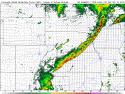
Yep, what saved Omaha itself from taking a direct hit was early in the afternoon a few storms developed and passed north of Omaha. In doing so they produced an outflow boundary (in essence a miniature cold front from the "outflow" or rain cooled air from the storm) that shifted south through the metro. A few hours later as the severe storms fired west of town, initially they headed straight toward Omaha but as they got closer, they embedded themselves on the outflow boundary (or what was left of it) which had stalled south of town. When chasing this is actually typically a "good thing" to have happen (assuming you want to see a tornado) as often when a storm embeds on a boundary, the low level helicity increases and consequently the tornado potential increases. In this case though, the storms were simple too outflow dominant so they would occasionally cycle and become supercellular (which is when they'd produce the largest hail) but then the outflow would undercut the storm and it would gradually weaken some before cycling up again. Saw reports of between golf ball and tennis ball sized hail with the storms as they moved though the area.Busguy2010 wrote: Wed Sep 19, 2018 2:07 pmIt was weird. What a relief it was for that period of time, about a 20 degree drop. The severe storms that hit Gretna/Louisville/Plattsmouth were headed directly for Omaha, but at the last moment, they shifted to a southeasterly track, so i was a little disappointed there. I saw there was great lightning with those. Im sure there are some posters here that saw it. Then, top off the weirdness with the fact that it gradually warmed up throughout the night. 71 was the "low" (the moment just before sunrise is the coolest probably 99% of the time, so I generally call it "the low" as a time indicator) and we warmed up to that.Omaha Cowboy wrote: Wed Sep 19, 2018 12:45 pm Tuesday was kind of a weird day temperature and humidity wise in Omaha.. The morning started out humid, by 3:30-4:00 in the afternoon, it was nice- cooler and not very humid at all.. Then by 9pm, warmer and humid again.. In between those times, there was a fairly strong series of thunderstorms..
I thought it was strange/different anyway.. I can’t wait for Friday!...
Ciao..LiO...Peace
I can't wait for Friday either, it's going to be just about my exact preferred temperature throughout the day (mid 60s during the day and low 50s throughout the night) after that is going to be upper 70s, a littler warmer than I like, though I know most people will appreciate it, myself included. Crossing my fingers that we'll see no more days in the mid 80's +.
Looks like a good chance for storms Thursday night. Any specifics on that would be appreciated.
As far as tomorrow, looking like strong/severe storms moving through the area late afternoon (possibly near rush hour depending on timing of course). A few storms may produce damaging wind/hail but the primary threat for tomorrow will be into southern MN and WI. Here is a simulated radar from the 3km NAM for tomorrow at 23z (6pm).
-
Uffda

- County Board
- Posts: 4618
- Joined: Sun Jun 12, 2005 9:52 pm
- Location: Land o Lakes, FL
Re: 2018 Severe Weather Thread
We were trying to rush to finish two XC races before the rain came. Got the girls race done but boys race was delayed because of an injury in the girls race. Back half of the boys race got caught in a down pour. And by the time the bus came to pick up the team the sun was shining.Omaha Cowboy wrote: Wed Sep 19, 2018 12:45 pm Tuesday was kind of a weird day temperature and humidity wise in Omaha.. The morning started out humid, by 3:30-4:00 in the afternoon, it was nice- cooler and not very humid at all.. Then by 9pm, warmer and humid again.. In between those times, there was a fairly strong series of thunderstorms..
I thought it was strange/different anyway.. I can’t wait for Friday!...
Ciao..LiO...Peace

We are the people our parents warned us about.
Jimmy Buffett
Jimmy Buffett
-
Coyote

- City Council
- Posts: 34366
- Joined: Tue Nov 18, 2003 11:18 am
- Location: Aksarben Village
Re: 2018 Severe Weather Thread
Yesterday afternoon was kind of strange, but it did leave this behind:
You do not have the required permissions to view the files attached to this post.
-
Busguy2010
- City Council
- Posts: 7322
- Joined: Sat Apr 09, 2011 7:32 pm
- Location: North Central Omaha
Re: 2018 Severe Weather Thread
Cool, I didn't even think to look for an outflow boundary on the radar, if it even registered. That's obviously what happened, but at the time, I assumed it was cooler from the storms coming in from the west. I recall thinking it was strange that it was so cool that far ahead of what I thought was going to be the storm that hit us. It makes total sense to me in hindsight, but as I learn more, I'll gain foresight and that'll be fun.stormchaser wrote: Wed Sep 19, 2018 6:14 pm Yep, what saved Omaha itself from taking a direct hit was early in the afternoon a few storms developed and passed north of Omaha. In doing so they produced an outflow boundary (in essence a miniature cold front from the "outflow" or rain cooled air from the storm) that shifted south through the metro. A few hours later as the severe storms fired west of town, initially they headed straight toward Omaha but as they got closer, they embedded themselves on the outflow boundary (or what was left of it) which had stalled south of town. When chasing this is actually typically a "good thing" to have happen (assuming you want to see a tornado) as often when a storm embeds on a boundary, the low level helicity increases and consequently the tornado potential increases. In this case though, the storms were simple too outflow dominant so they would occasionally cycle and become supercellular (which is when they'd produce the largest hail) but then the outflow would undercut the storm and it would gradually weaken some before cycling up again. Saw reports of between golf ball and tennis ball sized hail with the storms as they moved though the area.
As far as tomorrow, looking like strong/severe storms moving through the area late afternoon (possibly near rush hour depending on timing of course). A few storms may produce damaging wind/hail but the primary threat for tomorrow will be into southern MN and WI. Here is a simulated radar from the 3km NAM for tomorrow at 23z (6pm).
Thanks for the update on tomorrow. Looks like the NWS has upped the caution for tomorrow around 6 or 7 or something. If it pans out, it'll looks like it could be the first good squall line to come through here this year... Though, I'm not keeping my hopes up as storms have split up over us all year.
-
Omaha Cowboy
- The Don
- Posts: 1013711
- Joined: Wed Jan 07, 2004 5:31 am
- Location: West Omaha
Re: 2018 Severe Weather Thread
I’ve read that high school football games in the metro have been cancelled for this evening due to the weather...Busguy2010 wrote: Wed Sep 19, 2018 11:55 pmCool, I didn't even think to look for an outflow boundary on the radar, if it even registered. That's obviously what happened, but at the time, I assumed it was cooler from the storms coming in from the west. I recall thinking it was strange that it was so cool that far ahead of what I thought was going to be the storm that hit us. It makes total sense to me in hindsight, but as I learn more, I'll gain foresight and that'll be fun.stormchaser wrote: Wed Sep 19, 2018 6:14 pm Yep, what saved Omaha itself from taking a direct hit was early in the afternoon a few storms developed and passed north of Omaha. In doing so they produced an outflow boundary (in essence a miniature cold front from the "outflow" or rain cooled air from the storm) that shifted south through the metro. A few hours later as the severe storms fired west of town, initially they headed straight toward Omaha but as they got closer, they embedded themselves on the outflow boundary (or what was left of it) which had stalled south of town. When chasing this is actually typically a "good thing" to have happen (assuming you want to see a tornado) as often when a storm embeds on a boundary, the low level helicity increases and consequently the tornado potential increases. In this case though, the storms were simple too outflow dominant so they would occasionally cycle and become supercellular (which is when they'd produce the largest hail) but then the outflow would undercut the storm and it would gradually weaken some before cycling up again. Saw reports of between golf ball and tennis ball sized hail with the storms as they moved though the area.
As far as tomorrow, looking like strong/severe storms moving through the area late afternoon (possibly near rush hour depending on timing of course). A few storms may produce damaging wind/hail but the primary threat for tomorrow will be into southern MN and WI. Here is a simulated radar from the 3km NAM for tomorrow at 23z (6pm).
Thanks for the update on tomorrow. Looks like the NWS has upped the caution for tomorrow around 6 or 7 or something. If it pans out, it'll looks like it could be the first good squall line to come through here this year... Though, I'm not keeping my hopes up as storms have split up over us all year.
Ciao..LiO...Peace
Go Cowboys!