Omaha Cowboy wrote: Wed Sep 19, 2018 12:45 pm
Tuesday was kind of a weird day temperature and humidity wise in Omaha.. The morning started out humid, by 3:30-4:00 in the afternoon, it was nice- cooler and not very humid at all.. Then by 9pm, warmer and humid again.. In between those times, there was a fairly strong series of thunderstorms..
I thought it was strange/different anyway.. I can’t wait for Friday!...
Ciao..LiO...Peace
We were trying to rush to finish two XC races before the rain came. Got the girls race done but boys race was delayed because of an injury in the girls race. Back half of the boys race got caught in a down pour. And by the time the bus came to pick up the team the sun was shining.
That’s definitely a capsule of how crazy and weird the weather was this past Tuesday...
stormchaser wrote: Thu Sep 20, 2018 5:49 pm
I'd say the 3km NAM that I posted a screenshot of yesterday was pretty spot on...
Yep, I'd say it was good. So I'll tell you what I'm seeing and you can tell me the terminology for such movement if you'd like... So I can see the front is oriented SW-NE and generally moving straight east at a pretty slow rate. The storms along the front are also moving from SW-NE, indicating there will be several small cells that successively move in one by one, generally coming up along I-80. I think we'll have rain for at least a few hours.
Coyote wrote: Thu Sep 20, 2018 7:41 pm
We've been skirting the storm so far,
But, it looks like we will be hit from the SW soon.
I think it's because the front line is moving so slowly to the east. I think everything coming up the pike will eventually get to us with how slowly its moving
Yep, front moved slow. Storms kept forming behind the outflow boundary but ahead of the front so it's kinda turned into a HP/heavy rain mess in the area
Looks like after all this has moved through, the NWS has updated the forecast for tomorrow and its looking more likely that the earlier forecast last weekend will hold up with highs in the low 60's and a low in the mid 40's tomorrow night. That will be phenomenal.
Busguy2010 wrote: Thu Sep 20, 2018 9:30 pm
Looks like after all this has moved through, the NWS has updated the forecast for tomorrow and its looking more likely that the earlier forecast last weekend will hold up with highs in the low 60's and a low in the mid 40's tomorrow night. That will be phenomenal.
Yep, should get nice and chilly tonight. Then another strong cold front will move through the area again on Monday with more severe storms and another shot of 40s for lows behind it...and then maybe another strong cold front the following weekend (around Saturday). Either way, definitely transitioning into a typical fall pattern now...
I believe I heard KETV’s Bill Randby say late last week after Thursday’s 95 degree day, the metro is done with 90 degree temperatures for the rest of 2018..
Omaha Cowboy wrote: Mon Sep 24, 2018 12:48 pm
I believe I heard KETV’s Bill Randby say late last week after Thursday’s 95 degree day, the metro is done with 90 degree temperatures for the rest of 2018..
That’s probably a safe statement.. Right?...
Ciao..LiO...Peace
Heck by the look of the 10 day forcast we might be lucky to hit 80 again.
Omaha Cowboy wrote: Mon Sep 24, 2018 12:48 pm
I believe I heard KETV’s Bill Randby say late last week after Thursday’s 95 degree day, the metro is done with 90 degree temperatures for the rest of 2018..
That’s probably a safe statement.. Right?...
Ciao..LiO...Peace
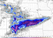
Yeah, 90s are looking unlikely anymore based on the long range GFS anyway. Seeing 80s are a bit more iffy - depends on timing of cold fronts/storm systems really. Possibly a severe weather event or 2 yet (again depending on timing, moisture return, etc) before the bottom looks like it will fall out in the first week of October. Lows near or below freezing being depicted currently with our first snowflakes the weekend of October 6/7 (extremely unlikely at this point - the GFS typically has a cold bias this time of year and likes to show snow in the long range typically but regardless, it's likely going to be below average for temps and probably our first "freeze" anyway).
Blue is snow, pink/purple is mix/ice on the image blow (just to clarify)
Coyote wrote: Mon Sep 24, 2018 8:56 pm
A freeze the weekend of Oct 6 would be a perfect ingredient for Fall Color!
its pretty much the exact average first frost for us, so I wouldn't be surprised. I garden and I plan everything around an average first frost of October 6th, so anything later than that is extra for me.
Coyote wrote: Mon Sep 24, 2018 8:56 pm
A freeze the weekend of Oct 6 would be a perfect ingredient for Fall Color!
its pretty much the exact average first frost for us, so I wouldn't be surprised. I garden and I plan everything around an average first frost of October 6th, so anything later than that is extra for me.
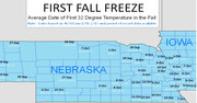
Maybe i’m wrong here, but I throught the average first Freeze for a Omaha was the 15th of October.. But a frost and freeze are different, so you’re probably right for a first Frost.. But like I stated earlier, I’ll take the early first freeze of the year on Oct 6th to rid ourselves of the West Nile Mosquito threat...
Omaha Cowboy wrote: Mon Sep 24, 2018 12:48 pm
I believe I heard KETV’s Bill Randby say late last week after Thursday’s 95 degree day, the metro is done with 90 degree temperatures for the rest of 2018..
That’s probably a safe statement.. Right?...
Ciao..LiO...Peace
Yeah, 90s are looking unlikely anymore based on the long range GFS anyway. Seeing 80s are a bit more iffy - depends on timing of cold fronts/storm systems really. Possibly a severe weather event or 2 yet (again depending on timing, moisture return, etc) before the bottom looks like it will fall out in the first week of October. Lows near or below freezing being depicted currently with our first snowflakes the weekend of October 6/7 (extremely unlikely at this point - the GFS typically has a cold bias this time of year and likes to show snow in the long range typically but regardless, it's likely going to be below average for temps and probably our first "freeze" anyway).
Blue is snow, pink/purple is mix/ice on the image blow (just to clarify)
Omaha Cowboy wrote: Tue Sep 25, 2018 12:32 pm
Maybe i’m wrong here, but I throught the average first Freeze for a Omaha was the 15th of October.. But a frost and freeze are different, so you’re probably right for a first Frost.. But like I stated earlier, I’ll take the early first freeze of the year on Oct 6th to rid ourselves of the West Nile Mosquito threat...
Ciao..LiO...Peace
It depends where you look. The NWS has first freeze at the 12th based on their map, but the first frost happens well before that. I'm using my gardening brain on this because most plants I grow can't tell the difference between 35 and 32, and neither can I really. Once it gets down to less than 36 that's my indicator even without reaching the freezing number. The first frost or freeze can be subjective as well. I, living down by a creek can have temperatures 3 to 5 degrees lower than at the top of my hill.
Coyote wrote: Mon Sep 24, 2018 8:56 pm
A freeze the weekend of Oct 6 would be a perfect ingredient for Fall Color!
No, you don't want a Freeze. Cool nights but not a freeze.
Accuweather wrote:Freezing conditions destroy the leaf's ability to manufacture the red and purple pigments. Early frost will end the colorful foliage.
Remember a couple years ago when the Loess Hills had a early freeze north of Omaha and we never got good color up there.
Cold is coming. Low of 25 last night in Alliance. Chadron and North Platte both hit 32.
Looking like a decent chance of severe weather sometime in the Monday-Wednesday time frame early next week - possibly more than 1 day depending on moisture return and capping...and of course timing (assuming the 12z GFS verifies anyway). Possibly a tornadic type event nearby on Wednesday depending on the timing of when the low pushes through the area but obviously that's way too far out to accurately predict. Either way looks like we will have at least a few days in the mid 80s in that time frame - before the bottom falls out (though not surprisingly the long range has backed off some on how cold it may get - but that's typical and I'm sure it will fluctuate back and forth as we get closer).
Interesting temperature swings the next few days and maybe a few strong/severe storms tomorrow afternoon. Highs in the 60s today, near 90 tomorrow and then back into the 50s on Thursday. Gotta love this time of year when seasons are transitioning...
stormchaser wrote: Tue Oct 02, 2018 11:34 am
Interesting temperature swings the next few days and maybe a few strong/severe storms tomorrow afternoon. Highs in the 60s today, near 90 tomorrow and then back into the 50s on Thursday. Gotta love this time of year when seasons are transitioning...
One last blast of Summer.. And, hopefully, the last severe thunderstorm threat for 2018...
stormchaser wrote: Tue Oct 02, 2018 6:00 pm
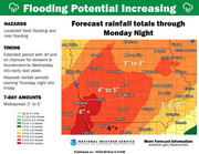
Looks like the heavy rain is about to return in the coming days too. These are forecast rain totals via the NWS through Monday..
We could be getting snow. That much rain sucks, but it could be worse.
Uffda wrote: Wed Oct 03, 2018 9:56 pm
Interesting day so far -- 91 degrees at 4:00 for a XC race -- 62 at 10:00p --- and that isn't even the predicted high for tomorrow
That was a dramatic drop off in temp yesterday indeed..
This morning, I turned the heat on in my house. 24 hours earlier, I had the central air conditioning running.. Gotta love these transitional weather months...
Awful news as a result of the non-thunderstorm winds associated with the strong frontal boundary (fairly common for this time of year). Unfortunately the 2 year old in Lincoln passed away. https://www.ketv.com/article/2-year-old ... d/23603114
looking like our first frost this year will be on 10/11, with a low of 35 forecast. I don't know what effect this will have on fall color or the Husker's fortune
Busguy2010 wrote: Tue Oct 09, 2018 10:24 pm
looking like our first frost this year will be on 10/11, with a low of 35 forecast. I don't know what effect this will have on fall color or the Husker's fortune
Especially when the first frost of the year was supposed to be on September 1st
Possibly some snowflakes on Sunday also...then things will start to warm up toward the middle/end of next week into more seasonable temps anyway (60s maybe 70s)
stormchaser wrote: Thu Oct 11, 2018 2:00 pm
...things will start to warm up toward the middle/end of next week into more seasonable temps anyway (60s maybe 70s)
Accumulating snow is being depicted on most forecast models Sunday for mostly just south of Omaha currently. It will be interesting if things trend north at all. Keep in mind, these snowfall totals are likely over done some since surface temps are warm and consequently snow won't accumulate very fast.



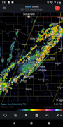




 snowflakes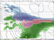
 ...
...