Coyote wrote: Sun Nov 18, 2018 8:09 pm
Is this a projection of an 8" accumulation?
Based on this model run anyway right around a foot of snow in Omaha itself with closer to 1.5 feet (or maybe even nearing 2 feet) of snow down by Lincoln.
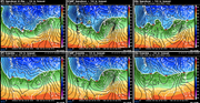
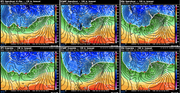
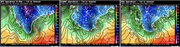
Still on track for a significant winter storm in the area late this coming weekend/early next week (Sunday/Monday specifically). Models are in fairly good agreement with showing a strong storm system although some differences on track do exist (which should be expected this far out). Attached are images of the 3 main operational long range forecast models. Each show the low pressure system (depicted with an "L" that I put on the map) in somewhat different locations. Northwest of this low is where the heavy snow will be located. The white line represents the approximate location of the rain/snow line with the black bars (aka "isobars") which represent very strong wind in areas where they are close together (like they are in eastern Nebraska).
Something to keep a very close eye on though. Definitely has the potential to put down well over 6" of snow in many locations with wind.
stormchaser wrote: Tue Nov 20, 2018 8:50 am
Still on track for a significant winter storm in the area late this coming weekend/early next week (Sunday/Monday specifically). Models are in fairly good agreement with showing a strong storm system although some differences on track do exist (which should be expected this far out). Attached are images of the 3 main operational long range forecast models. Each show the low pressure system (depicted with an "L" that I put on the map) in somewhat different locations. Northwest of this low is where the heavy snow will be located. The white line represents the approximate location of the rain/snow line with the black bars (aka "isobars") which represent very strong wind in areas where they are close together (like they are in eastern Nebraska).
Something to keep a very close eye on though. Definitely has the potential to put down well over 6" of snow in many locations with wind.
It looks ominous for sure. Weatherwise- What a way to close out what’s been, on balance, a lousy and cold November 2018...
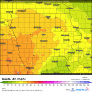
Heavy snow with blizzard conditions continue to look possible for this coming Sunday across our area. This is from the latest ECMWF forecast model run (the 12z). Just to stress, things can and likely will change some yet but snow totals near or in excess of a foot are possible in the Lincoln/Omaha area with nearing 1.5 feet toward Des Moines with winds gusting in the 40-50mph range. Of course this all depends on the exact track of the storm though...
Just to clarify, I'm sure forecast models are over estimating snow totals some with this (especially with how fast precip is expected to move through). Snow totals of 4"-8" or 6"-10" are probably more realistic but either way it will likely be a mess on Sunday with heavy snow and wind...
NWS showing almost .5" of rain Saturday night turning into almost 4" of snow Sunday morning. That's a lot of rain and I think how early that rain switches to snow could have some effect on the snow accumulation total. At the moment, I'll just be expecting 4" of snow knowing very well that it could be much more. Even if snowmageddon doesn't happen, 4" is still a healthy amount. Like always I'll be checking those snow predictions coming out of the NWS as it gets closer. They very well could change to a foot over the next two days.
Busguy2010 wrote: Thu Nov 22, 2018 12:43 pm
NWS showing almost .5" of rain Saturday night turning into almost 4" of snow Sunday morning. That's a lot of rain and I think how early that rain switches to snow could have some effect on the snow accumulation total. At the moment, I'll just be expecting 4" of snow knowing very well that it could be much more. Even if snowmageddon doesn't happen, 4" is still a healthy amount. Like always I'll be checking those snow predictions coming out of the NWS as it gets closer. They very well could change to a foot over the next two days.
Yeah, they are doing the typical conservative thing currently. I'd assume they'll start bumping up snow totals and issuing winter storm watches and possibly blizzard watches sometime tomorrow for the area though the worst may end up south and east of Omaha into Iowa
stormchaser wrote: Thu Nov 22, 2018 1:58 pm
Yeah, they are doing the typical conservative thing currently. I'd assume they'll start bumping up snow totals and issuing winter storm watches and possibly blizzard watches sometime tomorrow for the area though the worst may end up south and east of Omaha into Iowa
That's kinda what I'm expecting. But I still take most forecasts with a grain of salt as even our best forecasts seem to be wrong half the time. As usual, we'll be more confident the closer it gets.
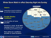
Winter storm watch has been issued for the Lincoln/Omaha area for late Saturday night and Sunday. The track of the storm has shifted south some though and in doing so has moved our area out of the heavier snow (which now looks to be from near Saint Joseph up toward Des Moines). Still obviously potential it could shift back north but regardless, the blowing snow will cause significant travel issues.
Based on the latest model trends, I'd say there is a decent possibility of getting 4-8 inches of snow in the Omaha area. Most models have started trending back north with the heavier snow (pretty much all except for the ECMWF) which is why I think the official forecast of around 3 inches of snow is too low. Only time will tell though
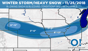
Made a map depicting my thoughts about this upcoming storm for the area. I included "eomahaforums.com" branding - let me know if this isn't okay and I'll remove it.
For Omaha itself:
Like normal it seems nearly every storm system for almost as long as I can remember over the last year or so has Omaha yet again on the edge of the potentially heavier snow. At this time, a conservative/safe bet would be to expect right around 3" of snow in Omaha itself with less to the north and more to the south. However, if the track of the storm shifts north at all, that number could quickly increase. Conversely, if the storm shifts south, we could end up with almost nothing for snow accumulation. Either way, visibility will be reduced from blowing snow (especially if accumulations do occur). Precip should start out as some rain tonight and transition to all snow relatively quickly during the overnight hours (probably after 3-4 am). The snow will be heavy at times. Aside from track, another challenge with this forecast is trying to determine how quickly snow will accumulate (heavy snowfall rates but surfaces are still warm) and how quickly the storm system/precip moves through (which is supposed to be relatively fast with much of the snow ending by early Sunday afternoon). The combination of the 2 makes me glad I don't forecast these things for a living .
Blizzard warnings issued for just south of Omaha including Lincoln. Still a decent chance Omaha will be added as well but depends how much snow we get.
I just got up and looked out. So far maybe an inch or so on the driveway and sidewalk. The way they were talking about it last night, I expected quite a bit more.
I use the Weather Underground app and the entire week leading up to this storm they never had any calculation higher than 4”. Even a week ago they were sure it wasn’t going to drop a foot.
Dry air pushed in from the north and cut off the snow locally sooner than expected (as already mentioned). Just to clarify, nobody thought we'd 100% get a foot of snow (or at least nobody I know did). Conversely there is no way to know 100% for sure we wouldn't either a week in advance. It's simply impossible to know without a doubt specifics like that. There was potential that we would (and there still is potential for areas just south and east of Omaha). Weatherunderground is an okay app but it's easy to say it was right in hindsight. They were just being conservative in their forecast (I'm not saying it's wrong to do that, but I think people should be made aware of the potential for much heavier snow too when the potential exists which is all I was trying to do). By last night it was fairly evident that Omaha would be missed by the heavy snow even though it would likely be very very close to us (which it is). Areas less than 30 miles south of Omaha will probably see snow totals approaching a foot as close as between Plattsmouth and Nebraska City. When you have a sharp cut off in snow like that, it's nearly impossible to forecast exactly where that cut off will be. In this case it missed Omaha. Impossible to know for sure that was what would happen though - especially days in advance. I have, however, been saying for several days the heavier stuff (the snow totals approaching a foot anyway) would likely miss Omaha to the south and east unless there was a last minute shift back north (which sometimes happens - in this case it didn't)
I mean look how close this is. Less than 30 miles away will likely see nearing a foot of snow with wind. A full fledged blizzard. We are extremyely lucky Omaha missed it
Reports of ~6 inches of snow in Lincoln with even more toward Beatrice and whiteout conditions. Travel is likely nearly impossible south of Omaha about 30 miles. I-80 is apparently closed from Waverly on West too and apparently they are about to shut down I-29 south of Omaha also...
I half love half hate winter. The part I love about winter storms is the abundance of snow, the part I hate is ice and wind, so it looks like this one is a major disappointment for me. Was expecting at least 3" and barely got 1/2"
Busguy2010 wrote: Sun Nov 25, 2018 12:52 pm
I half love half hate winter. The part I love about winter storms is the abundance of snow, the part I hate is ice and wind, so it looks like this one is a major disappointment for me. Was expecting at least 3" and barely got 1/2"
I’m personally VERY happy the brunt of this storm completely missed Omaha (unfortunately, the cold and wind didn’t)..
Nothing like having to dig out of a major snow event before going back to work on Monday, lol.. I live in the 132nd and West Center area and I’d say a dusting to about 1/2 inch of snow accumulated.. I think Lincoln ended up with 3 inches officially..
A week ago today, I was hearing reports that Omaha “could” get up to a foot of snow.. Then as late as mid week, I heard of the possibility of 6-8 inches.. Then by Friday/Saturday, most predictions were 3-4 inches.. So I was delighted to wake up this morning and see hardly any snow fell.. Dry air in the wintertime is a wonderful thing ...
Omaha Cowboy wrote: Sun Nov 25, 2018 7:18 pm
I’m personally VERY happy the brunt of this storm completely missed Omaha (unfortunately, the cold and wind didn’t)..
I just like to experience different weather. If we get more than a week or ten days of stable weather I start to get pretty depressed, even if its perfect weather. Interesting thought, maybe my body doesn't respond to high pressure systems. Well anyway, I need variety and was hoping for some snow to shovel or to whip around on the neighborhood streets or something.
I was so happy to wake up to bare pavement on my driveway and sidewalks this morning. I get so tired of all the over hype the local TV weather people force us to endure, all year long. It seems that if they can’t try to make a mountain out of a molehill then they can’t justify their jobs.
Yes, I understand it snowed more down toward St. Joe and KC. I saw it on the national news. But that is not the same as predicting 2-4 inches in Omaha then we end up with a half inch on the grass. They blew the forecast for 800,000 or more people. It just leads to a “chicken little” phenomenon where sooner or later no one believes anything they hear come out of these people’s mouths. I’ve lived in Omaha for 6 decades and the amount of time our storms are over-hyped is 10 times the number of times they are understated.
I would much rather wait for winter weather to show up in winter, and not in November.
nativeomahan wrote: Sun Nov 25, 2018 11:05 pmI get so tired of all the over hype the local TV weather people force us to endure, all year long. It seems that if they can’t try to make a mountain out of a molehill then they can’t justify their jobs.
This annoys me to all ends as well! I **REALLY** wish they would quit sensationalizing the winter weather!
On Saturday they were making like it was gonna be a rewind-replay of the Great Blizzard of 1888. Then on Sunday, they had "Near-blizzard conditions" and "Travel not advised" crawls on the network programs. No excuse for that drek!
Mid morning Sunday I went out hoping to photograph some scenic snow. I didn't find anything. Very little accumulation.
nativeomahan wrote: Sun Nov 25, 2018 11:05 pmI get so tired of all the over hype the local TV weather people force us to endure, all year long. It seems that if they can’t try to make a mountain out of a molehill then they can’t justify their jobs.
This annoys me to all ends as well! I **REALLY** wish they would quit sensationalizing the winter weather!
On Saturday they were making like it was gonna be a rewind-replay of the Great Blizzard of 1888. Then on Sunday, they had "Near-blizzard conditions" and "Travel not advised" crawls on the network programs. No excuse for that drek!
Mid morning Sunday I went out hoping to photograph some scenic snow. I didn't find anything. Very little accumulation.
I hear what you're saying and some do tend to sensationalize (typically because a TV producer pressures them to, not because they choose to) but at the same time it WAS a full fledged blizzard for much of the area - just not in Omaha itself this time (less than 30 miles to our south it was very bad). In their defense though a blizzard warning was never issued for Douglas or Sarpy County - we only had a winter weather advisory prior to the storm with blizzard warnings starting directly south of Sarpy County. While snowfall amounts ended up being less than forecast locally (we were expected to get around 3" of snow with accumulations increasing dramatically just to our south, which they did) it still wouldn't have probably met blizzard criteria locally even if we had gotten 3" of snow since what had fallen was fairly heavy/icy/not easy to blow around. The issue, IMO is equally an issue with people's understanding of weather/forecasting. For example (to clarify I'm not referring to anyone here), a blizzard warning is issued and consequently talked about on the evening news the night before the storm. Despite the fact the person watching does not live in a county that has a blizzard warning (the blizzard is expected to pass south of them), they still "hear" blizzard and assume/expect worst-case-scenario for them (despite the fact its expected to pass to their south). Then the storm passes and as expected goes south of their location and that person is consiquently upset because they expected a blizzard and it didn't happen so it's the weather guys fault (again, just to stress I'm honestly not referring to anyone - just using an example similar to what actually happened because it's fresh in our minds). Scenarios like this are all too common this time of year and equally frustrating for weather people.
Just a heads up, another potentially significant winter storm being depicted on pretty much all long range models for this coming weekend. Anytime all of the long range models are in good agreement like this, odds of it happening increase fairly drastically. Of course it's impossible to know exactly where and what impacts to expect yet but it "could" be another blizzard for somewhere in the region.
Here is what the 00z ECMWF shows for snowfall in the area. This undoubtedly will change (maybe drastically) but just to give people an early look at the potential anyway.
Got to love how in situation 1 there is no forecast for much snow and everyone goes off the deep end when we get a storm and no one was warned or ready.
Situation #2 there is a storm predicted and the front shifts a little and everyone goes off because we don't get what is forecasted.
For the record NEBUGEATER does not equal BUGEATER !!!!!!!
nebugeater wrote: Mon Nov 26, 2018 6:24 pm
Got to love how in situation 1 there is no forecast for much snow and everyone goes off the deep end when we get a storm and no one was warned or ready.
Situation #2 there is a storm predicted and the front shifts a little and everyone goes off because we don't get what is forecasted.
Dammed either way. Your average Joe just sees a weather man and forecasters getting paid to be right, but what they don't see is the analysis that happens off camera by many people ahead of a storm. Immeasurable commitment to trying to get things right, and when they don't get it right, they are the scapegoat. Feel bad for em. People can't figure out that mother nature is completely unpredictable, we just try to. Better than having no clue at all.
nebugeater wrote: Mon Nov 26, 2018 6:24 pm
Got to love how in situation 1 there is no forecast for much snow and everyone goes off the deep end when we get a storm and no one was warned or ready.
Situation #2 there is a storm predicted and the front shifts a little and everyone goes off because we don't get what is forecasted.
Dammed either way. Your average Joe just sees a weather man and forecasters getting paid to be right, but what they don't see is the analysis that happens off camera by many people ahead of a storm. Immeasurable commitment to trying to get things right, and when they don't get it right, they are the scapegoat. Feel bad for em. People can't figure out that mother nature is completely unpredictable, we just try to. Better than having no clue at all.
Coyote wrote: Mon Nov 26, 2018 8:30 pm
[youtube]
[/youtube]
Lol, love it.
Still on track for a significant storm sometime in the Saturday through Monday time frame (possibly 2 pieces of energy or 1 - either way, potential for heavy snow and blizzard conditions again). Just to be 100% clear, this doesn't mean Omaha will be hit. It means it has the potential of being hit and things need to be watched closely as the odds of a significant storm in the area are fairly high at this point - it's just a matter of track/timing, if it ends up being a single piece of energy or 2 separate pieces, precip type, etc etc
Forecast models are trending colder with this weekend's storm(s) across the area. If this happens, significant snowfall is likely in eastern Nebraska -parts of western Iowa may also see a significant ice storm. The differences from a degree or 2 change - gotta love trying to forecast it.
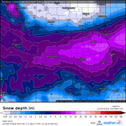
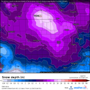
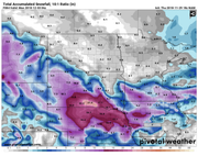
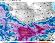
For whatever reason the local media has been down playing the potential for this weekend (probably because Omaha was mostly missed last weekend so they are being way more conservative). I take the approach of informing people of both the potential and uncertainty. Attached are snowfall maps for the latest ECMWF and NAM forecast models. Please note, these snow totals are likely over done but even if they are, wow this could be a big snow storm (with wind) for the area...
My weather underground app called for .9" of snow/accumulation from last Wednesday all the way til the storm hit. Today it says we are supposed to get .58" of rain Friday/2" of snow Saturday/2" of snow on Sunday/.7" of snow on Monday.
Total snow of 4.7"...let's see how close that is compared to the 1-9" that the local news will say we get.
milesej05 wrote: Wed Nov 28, 2018 9:28 am
They will be way off again this weekend.
My weather underground app called for .9" of snow/accumulation from last Wednesday all the way til the storm hit. Today it says we are supposed to get .58" of rain Friday/2" of snow Saturday/2" of snow on Sunday/.7" of snow on Monday.
Total snow of 4.7"...let's see how close that is compared to the 1-9" that the local news will say we get.
The problem with weather apps though is they use computer generated forecasts based on what forecast models are showing (i.e. they usually just use an average and lack the skill/knowledge needed to forecast that only a Meteorologist possess) - they aren't able to factor in trends, how well or poorly certain models are performing and which models should be ignored/favored based on trends, model strengths/weaknesses (for example the GFS tends to have a cold bias typically), etc etc. I personally don't rely on what the local news says though for snow totals (since I just forecast for myself) but I wouldn't rely too heavily on any app personally either. Either way any snowfall forecast this far out is just a guess and the apps accuracy in most cases will be extremely low (sure, once in a while the app will be right but in the long run it won't - at least not regularly). Also, no Meteorologist is going to forecast a range of 1"-9" (or at least I'd hope not ). They have to forecast a range though because they aren't forecasting for a single location - they are forecasting for a region. It's WAY easier to forecast snow totals for a single location (I'm probably stating the obvious). Either way it will be interesting to see what happens .
Last edited by stormchaser on Wed Nov 28, 2018 4:17 pm, edited 1 time in total.
I'm feeling comfortable with rain. Lots of cold rain, then snow Sunday morning, but only a little. Could be interesting if temp goes from steady 35 or 36 to colder, but I won't be betting on it.
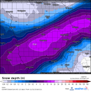
Southward trend has been noted on the forecast models so far today. Will be interesting to see if this trend continues on the 00z run. Here is what the 18z NAM is showing for snow totals in the area currently for this weekend into Monday. I'm sure these totals are over done but some places will likely see between 1 and 2 feet of snow, espeically in northern Nebraska. Also, things will likely change yet...
Based on this run, Omaha would likely see 6"-10" of snow (though it shows over a foot nearby). Keep in mind when the precip transitions to snow will be key. Problems with ice accumulation may be an issue to keep an eye on as well. Realistically right now my thinking is Omaha gets 3-6 inches...but it's just a guess at this point still.
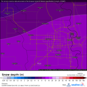
Latest 00z NAM shows a continuation of the southward trend seen on the last couple of model runs with Omaha still seeing heavy snowfall (in this case it depicts 12.1" of snow locally). Realistically, I'm thinking 6"-8" of snow IF (and it's a big if) precip changes to all snow soon enough. That's 100% the main factor at this point with figuring out how much snow Omaha actually gets - trying to determine precip change over time to all snow. If it holds off though and stays rain longer, then 3"-6" of snow is probably realistic.
Anyhow, here are the depicted snow totals from the 00z NAM. Still a lot can change though yet obviously...




 .
.

 ...
...