RockHarbor wrote: Tue May 07, 2019 8:10 pm
Wow... That may be Lincoln's first tornado ever. I dont think the city has ever been hit so far, as opposed to Omaha's count of several times.
Boy, do I feel dumb. Lol. Thanks for pointing that article out. I have never heard of a major maxi tornado hitting Lincoln, but I had no idea that the city has dealt with so many small twisters through the years. Gosh, I dont think Omaha could boast (if that is even the right word) a "family album" of small rope twister photos like that. Omaha has had two devastating maxi twisters, though. It almost seems like Lincoln is the "Skinny Twister Capitol" to me now. Course, one of the widest twisters ever recorded hit south of Lincoln.
Notice what a busy year 1975 was in Eastern NE? I had no idea Lincoln had a small twister in April 1975, and another big funnel north of town in 1975. Omaha had a small tornado in March 1975, and the big one on May 6, 1975. With this new info, that makes me look at Omaha's 1975 event as possibly part of a greater meteorological pattern in the region that was maybe turbulent that specific year. It does seem like, in general, years are either really busy or totally quiet to me.
I can get pushed out because I'm "too much" for some. Then, an observer of me comes suddenly swooping in to "fill my shoes." People are always more accepting of the new one, because their feathers aren't truly ruffled by them. (Yawn) I can count on it every time.
RockHarbor wrote: Tue May 07, 2019 8:10 pm
Wow... That may be Lincoln's first tornado ever. I dont think the city has ever been hit so far, as opposed to Omaha's count of several times.
That's really cool. Even though the photos are in black and white, if you know what you're looking for, you can extrapolate and imagine how those storms looked to the naked eye on those days in history.
A cool reminder that thunderstorms haven't changed.. Our population coverage and ability to take high-quality photographs, as well as share them with an endless amount of people is a blessing to the storm lover. I can't fathom how many storms have occurred, and either nobody saw them, nobody could take pictures or share their stories. There's probably a large number of magnificent thunderstorms that have gone undocumented.
iamjacobm wrote: Wed May 08, 2019 10:31 am
I don't recall where it was talked about, but they pulled the barriers off of 29 today so KC should be a lot easier to get to.
Interstate 29 has reopened — with some restrictions — from the Glenwood, Iowa, interchange to Missouri.
The stretch of interstate has been closed since March floods damaged the highway, cutting off the major north-south route and the main highway passage from the Omaha metro area to Kansas City.
But construction crews have made steady progress on repairs, leading to Wednesday morning's announcement of the reopening. Officials had targeted June for the reopening, then recently moved up the schedule to Memorial Day.
The reopening covers the route from U.S. Highway 34 near Glenwood to the Missouri border. Even so, officials said drivers can expect occasional lane closures and head-to-head traffic for one mile over a southbound bridge at mile marker 8.5, according to the Nebraska Department of Transportation.
Hwy 34 still remains closed from Bellevue across the bridge to Glenwood.
Brad wrote: Wed May 15, 2019 8:23 am
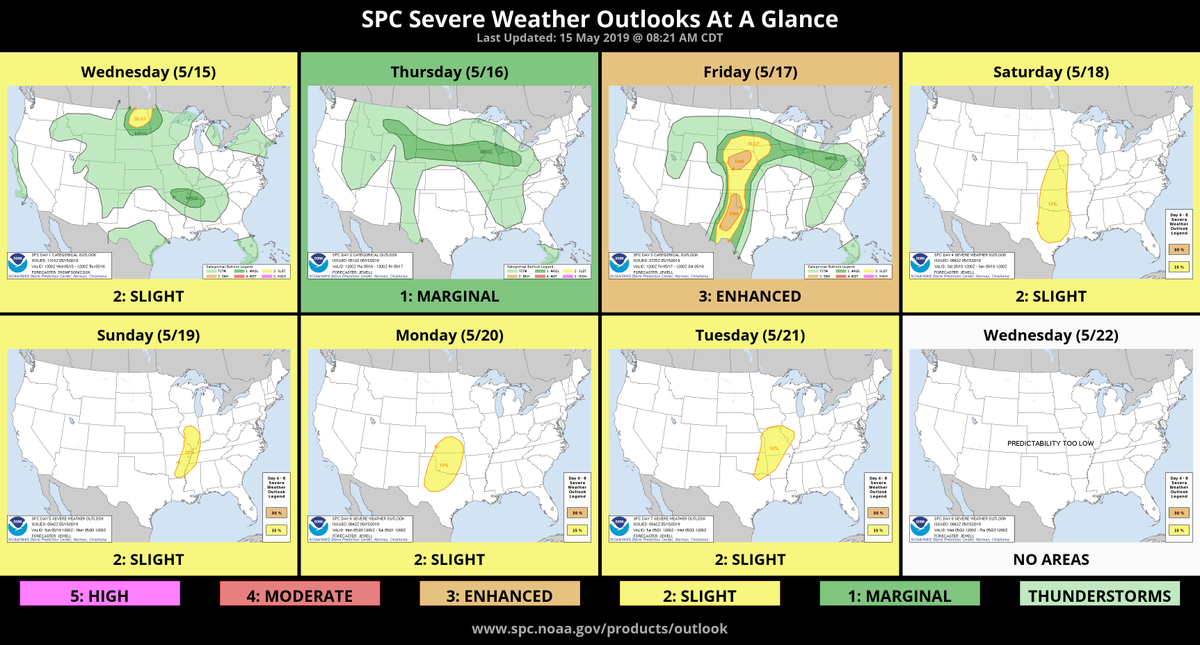
Below is the SPC outlook for Friday. Also chances on Thursday and Saturday too.
SPC-3-Day.JPG
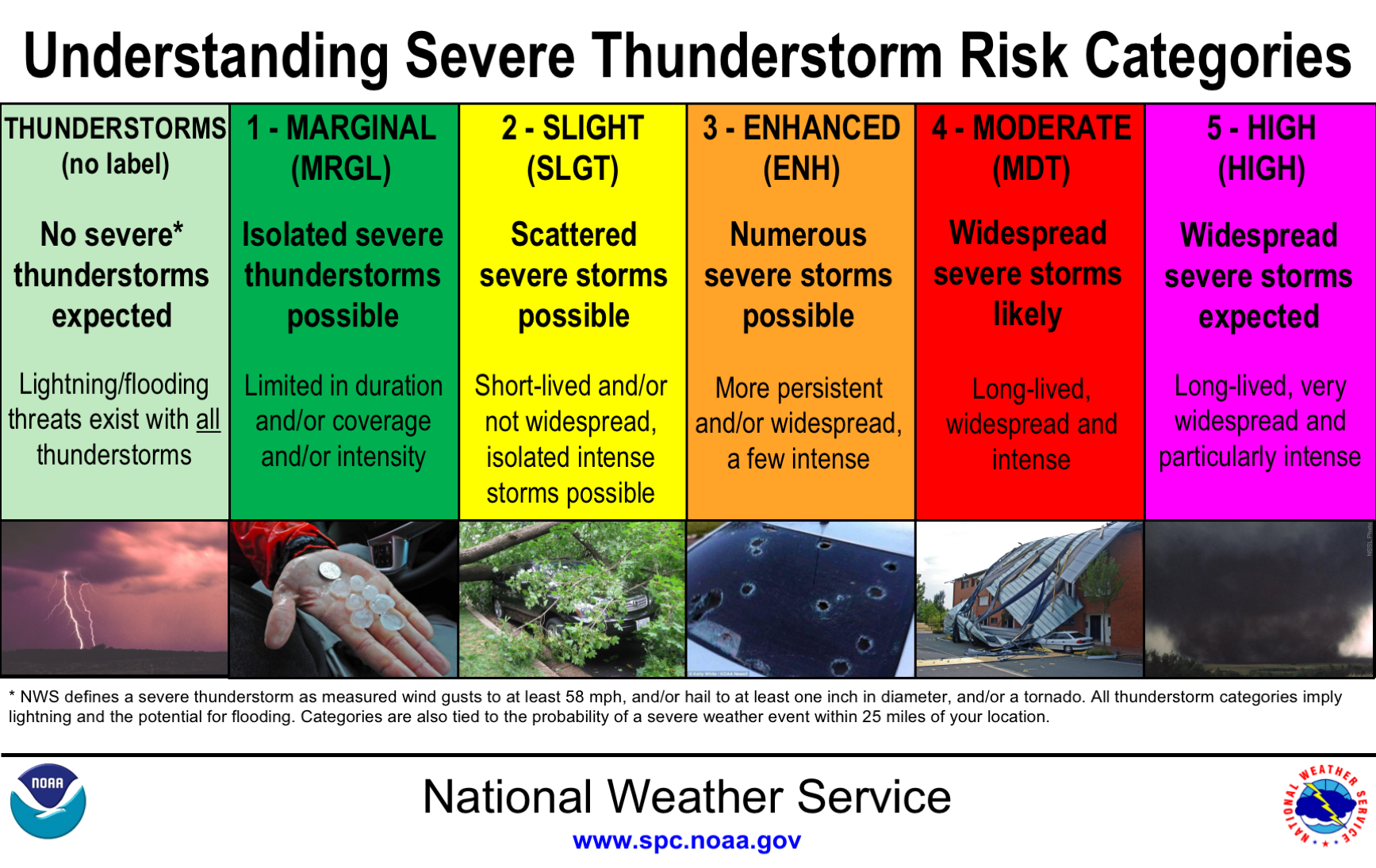
Thanks for the info, but am I the only one that find the NWS terms "Marginal", "Slight" and "Enhanced" confusing and misleading when "Very-Very-Low", "Very-Low" and "Low" would be more accurate.
lonnie wrote: Wed May 15, 2019 9:44 am
Thanks for the info, but am I the only one that find the NWS terms "Marginal", "Slight" and "Enhanced" confusing and misleading when "Very-Very-Low", "Very-Low" and "Low" would be more accurate.
Another thing that is often overlooked when people look at the SPC outlook maps, the areas defined mean there is a chance WITHIN 25 MILES of a location. Here is a map with a 25 mile radius centered at I80 and I680. That 25 Mile radius covers a large area. So just because Omaha doesn't get hit mean they blew the forecast 'again'. There have been many time recently where Omaha was in the forecast area and while Omaha didn't get anything bad, Blair, Missouri Valley, etc have been drilled.
25-mile-circle.JPG
You do not have the required permissions to view the files attached to this post.
I usually take the outlook with a grain of salt until the day of. The way I look at this one is "If the enhanced area moves east, or theres a moderate area added somewhere around here, then I'll get excited".
In the scope of things, enhanced is pretty up there, considering the things that have happened on days we were at moderate risk. On that thought, ever since I've started following the convective outlook, we've never been at high risk. Does anybody recall a day we were at high risk?
I recall the last time I remember being at moderate risk, the Blair hailstorm happened, and the sirens went off around Omaha, but not much really happened in Omaha, outside of a not-quite-menacing sky.
Again, enhanced is essentially 3/5, so that's actually pretty good. A good way for me to think of it is "How good do I feel about my favorite NFL quarterback completing a pass?" Then, the throw could be perfect and its dropped, or deflected, or otherwise not caught. And how many of those passes actually turns into a (tornado) touchdown? That's about what enhanced amounts to.
If you look at just the forecast, Saturday appears to be the better chance. Since Saturday is the 4th day, they haven't gone to much detail on the outlook. I'd expect more to happen on Saturday, but still not too excited about it yet.
lonnie wrote: Wed May 15, 2019 9:44 am
Thanks for the info, but am I the only one that find the NWS terms "Marginal", "Slight" and "Enhanced" confusing and misleading when "Very-Very-Low", "Very-Low" and "Low" would be more accurate.
here is a simplified graphic explanation of it here:
OK, replacing "Marginal", "Slight" and "Enhanced" -> "Isolated", "Scattered" and "Numerous" would be a lot better for those without the NWS cheat sheet.
@Busguy2010 makes some good points that the whole scale may need to be revisited.
Well, I’m happy to see we’re now at mid May, and have had no severe thunderstorm or tornado threat in the Omaha metro..
I know it’s sort of exciting to see the area in a possible severe weather threat zone for the next few days..but I’d perfectly fine if the bark was worse than the bite...
I'm sorry: No severe thunderstorm warnings or watches YET? The weather is obviously different back there... The weather almost feels like a "dud ladyfinger" (dud firecracker) to me back there now, compared to growing up. Even a lady I talked to in the middle of Iowa agrees there are less tornadoes back there now. Yet, that's not a bad thing....of course. I guess the "exciting weather" to look for is the drenching rain events.
I can get pushed out because I'm "too much" for some. Then, an observer of me comes suddenly swooping in to "fill my shoes." People are always more accepting of the new one, because their feathers aren't truly ruffled by them. (Yawn) I can count on it every time.
Are the ingredients finally coming together there to make the sparks fly?!?! If not, I'm thinking we're back to the "dud ladyfinger" weather pattern that is disappointing to me, and I'm sure others. (Course, Lincoln just had that small twister.) A lot of people like a good T-storm now & then -- a sky and clouds that are illuminated by "weather's fireworks." That's all. I'm not necessarily talking tornadoes, or alarming severe weather, passing through Omaha.
I can get pushed out because I'm "too much" for some. Then, an observer of me comes suddenly swooping in to "fill my shoes." People are always more accepting of the new one, because their feathers aren't truly ruffled by them. (Yawn) I can count on it every time.
Where I'm at right now looks pretty cool with the three big tower cranes at Children's all pointing northeast with the thunderclouds building in the background. Almost like they were expecting something to happen. Too bad I can't take a picture.
RockHarbor wrote: Thu May 16, 2019 7:25 pm
Are the ingredients finally coming together there to make the sparks fly?!?! If not, I'm thinking we're back to the "dud ladyfinger" weather pattern that is disappointing to me, and I'm sure others. (Course, Lincoln just had that small twister.) A lot of people like a good T-storm now & then -- a sky and clouds that are illuminated by "weather's fireworks." That's all. I'm not necessarily talking tornadoes, or alarming severe weather, passing through Omaha.
As eager as I am in May, I always bring it back down because I know our most active month is June. I expect stuff to happen in June, while I hope for stuff in May.
There is currently a large, probably rather entertaining thunderstorm east of Columbus. We are lucky anything is happening that close to us today. Now, tomorrow looks more promising, and I will be slightly disappointed if I don't see a little something. Even if that means driving myself up to the "plateau" as I call it (the highlands up in far northwest Omaha) to see a little lightning show in the distance.
Busguy2010 wrote: Thu May 16, 2019 8:54 pm
It's a big one that just missed us. Though, it is rotating, so a small insignificant portion of the tail end could whimper for us.
I don't want anything bad to hit anybody, but I'm just glad to see the weather doing NORMAL things. Good to see.
I can get pushed out because I'm "too much" for some. Then, an observer of me comes suddenly swooping in to "fill my shoes." People are always more accepting of the new one, because their feathers aren't truly ruffled by them. (Yawn) I can count on it every time.
Yesterday, a lightning strike lit a power pole on fire next door to the grad party I was at in Shawnee, KS. Smelled awful, even through the heavy downpour.
Wow, not looking good for our friends to the south. You don't see the "High" thrown out too often. I read some cities are even closing their schools today because of the forecast.
outoolk.JPG
You do not have the required permissions to view the files attached to this post.
Brad wrote: Mon May 20, 2019 8:41 am
Wow, not looking good for our friends to the south. You don't see the "High" thrown out too often. I read some cities are even closing their schools today because of the forecast.
Training storms means flooding, too. Fifty MPH storm speeds, lousy roads and nonexistent T/Td spreads means you won't see the tornado that kills you!
zippy wrote: Sun May 19, 2019 5:02 pm
Yesterday, a lightning strike lit a power pole on fire next door to the grad party I was at in Shawnee, KS. Smelled awful, even through the heavy downpour.
The worst lightning storm Ive ever encountered was in Kansas City one time. It was scary. It was like the bolts were alive and angry -- and out to get people, or something. It made you get away from the windows and stay in the center of the house. It reminded me of the lightning in "Raiders of the Lost Ark", or in the more recent movie "Geostorm." Your comment made me remember that. Lightning is something to always take very serious. I have a distant relative who died from lightning up in the mountains.
I can get pushed out because I'm "too much" for some. Then, an observer of me comes suddenly swooping in to "fill my shoes." People are always more accepting of the new one, because their feathers aren't truly ruffled by them. (Yawn) I can count on it every time.
Uffda wrote: Mon May 20, 2019 11:32 pm
Heavy wet snow in Colorado/Wyoming and Western South Dakota. A friend in Denver can hear branches breaking all over her neighborhood.
I80 is closed in Western Nebraska this morning (May 21st) because of snow!
Another severe threat for tomorrow night. Kinda caught me off guard. With all this cool weather, I figured we'd be quiet for at least five days, but that looks like that might not be the case.
Wow, there has been a lot of severe weather back there suddenly...
I can get pushed out because I'm "too much" for some. Then, an observer of me comes suddenly swooping in to "fill my shoes." People are always more accepting of the new one, because their feathers aren't truly ruffled by them. (Yawn) I can count on it every time.
It's hard to tell if it'll make it here, but there is currently a large severe thunderstorm west of Lincoln, moving closer to north than northeast, but it appears the whole complex is rotating back around, so I wouldn't be surprised by an easterly shift that could put us directly in the path.
Omaha Cowboy wrote: Thu May 23, 2019 7:43 pm
A Severe Thunderstorm Watch has just been issued for the Omaha area until Midnight tonight...
Ciao..LiO...Peace
I like the sound of that... Let nature's games begin!
I can get pushed out because I'm "too much" for some. Then, an observer of me comes suddenly swooping in to "fill my shoes." People are always more accepting of the new one, because their feathers aren't truly ruffled by them. (Yawn) I can count on it every time.
Omaha Cowboy wrote: Thu May 23, 2019 10:35 pm
The lightening was extremely intense.. Especially between 9 and 10 PM...
Ciao..LiO...Peace
I saw some good ones around me at that time, but nothing intense where I was at. The same strike I see from afar has a much greater impact on people closer to it. There were definitely a lot of strikes around the metro.
How many and how close were the ones you experienced?
Omaha Cowboy wrote: Thu May 23, 2019 10:35 pm
The lightening was extremely intense.. Especially between 9 and 10 PM...
Ciao..LiO...Peace
I saw some good ones around me at that time, but nothing intense where I was at. The same strike I see from afar has a much greater impact on people closer to it. There were definitely a lot of strikes around the metro.
How many and how close were the ones you experienced?
As I left the HyVee at 132nd and Dodge about 9:30pm and drove home, southbound on 132nd.. Multiple, frequent and dangerous lightening strikes all within what appeared to be a 1 to 4 mile radius.. Followed by thunder and torrential, I mean torrential rain...






 ...
...