Probably should get the 2020 severe weather thread going - looking like a pretty good chance for strong/severe storms in the Omaha area including the threat for tornadoes tomorrow.
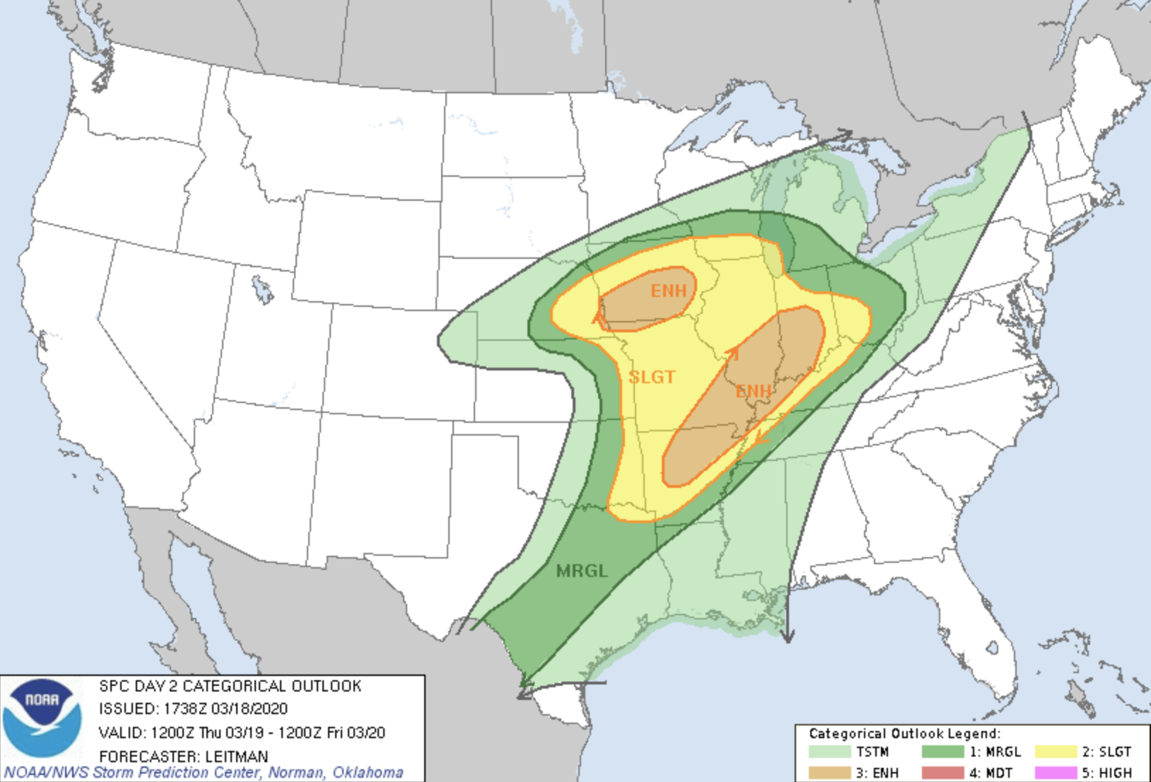
The Storm Prediction Center currently has an "enhanced risk" for severe weather in our area for tomorrow.
Don't let that graphic fool you though into thinking the risk is only east of town though. The short/medium range forecast models have been consistently nailing Omaha with strong/severe storms with the low pressure/warm front moving right over our area (the triple point/low pressure and warm front is where you'll find most tornadoes). It looks like most tornadoes should be brief (if they occur tomorrow) but I honestly wouldn't be surprised if a stronger one happens somewhere close to Omaha itself - just hopefully not in town but unfortunately it is fairly likely they will be close. Regardless, I'll be out chasing. Large hail and damaging wind will also be a threat with these storms.
Brad wrote: Wed Mar 18, 2020 4:03 pm
Thanks for getting the thread started. Looks like the Blizzard Warnings will be chasing the Tornado Warnings too.
Yep - looking like storms during the afternoon in Omaha followed by snow tomorrow night (albeit minor in our area anyway). Gotta love this time of year
damonhynes wrote: Wed Mar 18, 2020 4:16 pm
This time of year, the storm speeds can be above 70MPH! You don't chase these, you just hope to get in the way of one :-)
Yep, in general anyway . That said tomorrow the storm speeds don't look terrible. I'm sure they'll be fast movers but hopefully I can keep up. If not I'll just find a spot and wait...lol.
My bigger concern is moisture depth and a crashing cold front (as far as killing off the supercell/tornado potential anyway). Obviously I don't want to see anything damaged or anyone hurt (just to clarify).
Busguy2010 wrote: Wed Mar 18, 2020 6:30 pm
Dang what's the timing on this? I'm still waking up from winter and hung over on Corona. Severe weather hasn't even been on my radar.
Most of the “fun” tomorrow should be between 3pm and 7pm. I’m actually fairly concerned that people will be caught off guard by this considering it’s fairly early, we just had snow and with the Covid-19 stuff going on...
Busguy2010 wrote: Wed Mar 18, 2020 6:30 pm
Dang what's the timing on this? I'm still waking up from winter and hung over on Corona. Severe weather hasn't even been on my radar.
Most of the “fun” tomorrow should be between 3pm and 7pm. I’m actually fairly concerned that people will be caught off guard by this considering it’s fairly early, we just had snow and with the Covid-19 stuff going on...
I mean, me too. I'm caught off guard, and I know about it now. Imagine knowing nothing and hearing sirens go off tomorrow. Just goes to show that knowing what to look for in the sky is important. Not that I particularly am in the mood right now. Brain is toast from all the Corona news.
Maybe, most models are showing a “bullseye” for potential tornado activity near Omaha on both the HRRR and 3km NAM. Won’t really know until morning but odds have been continuing to increase throughout today at least that it will be close to here
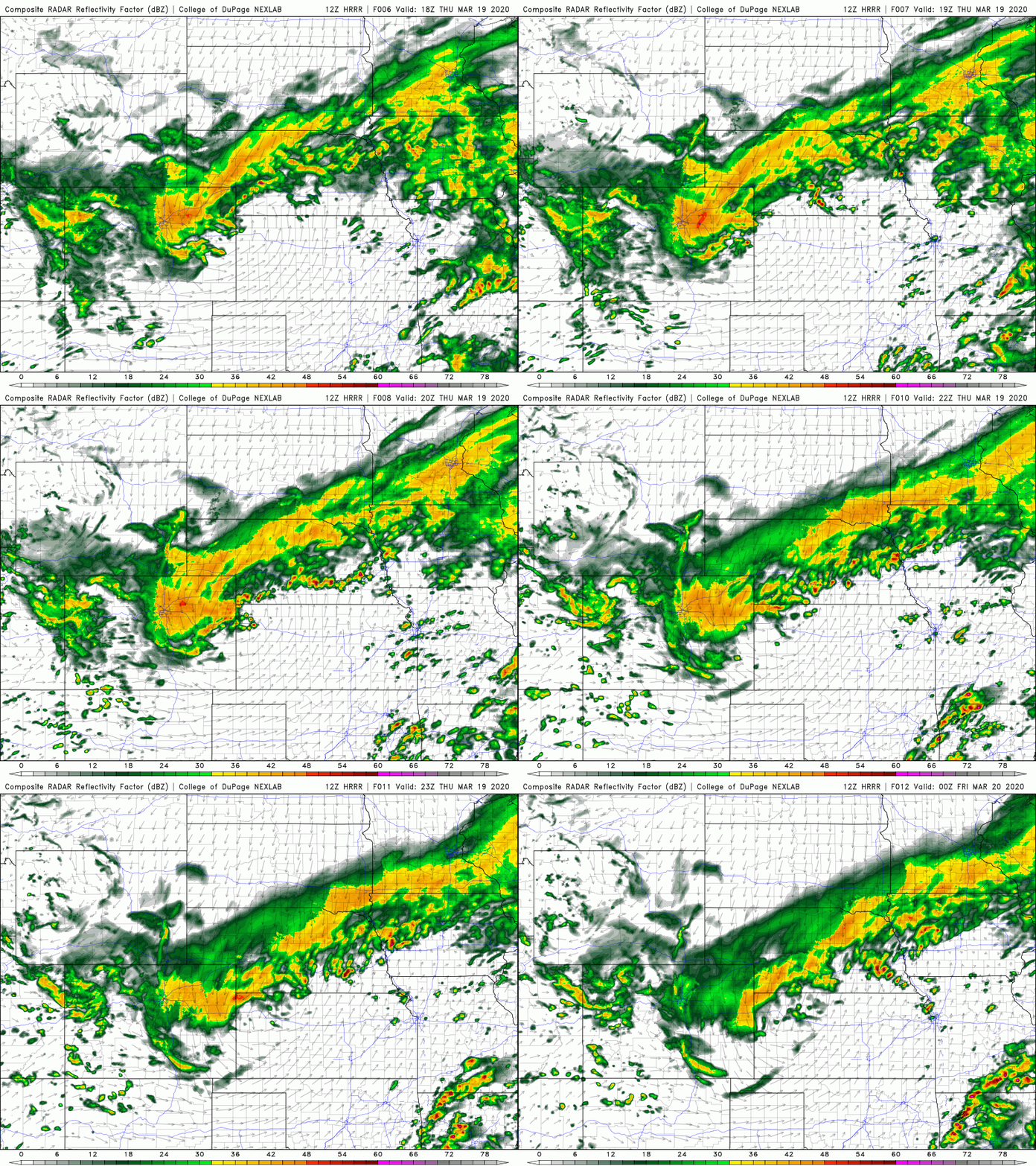
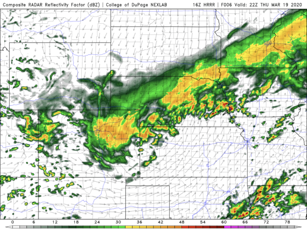
In case anyone is wondering - I'm currently thinking strong/severe storms (possibly tornadic depending on where the warm front ends up and if the storms can remain discrete) will impact the Omaha area sometime around 4pm with additional potentially tornadic storms developing southwest of town and passing between Omaha and Nebraska City around 6pm.
Here is a simulated radar loop showing these potential storms based on the 12z HRRR forecast model (just to clarify, this is just to show people roughly what I'm thinking, exact locations will depend on where the boundaries end up, etc):
Got dang I had some close ones this morning! According to lightning maps, I had more that 20 strikes within a mile of me, and a handful within a few blocks! Wow!
Busguy2010 wrote: Thu Mar 19, 2020 12:26 pm
Got dang I had some close ones this morning! According to lightning maps, I had more that 20 strikes within a mile of me, and a handful within a few blocks! Wow!
Yep - it was fun!
Still looking like tornadic potential is fairly high in the area with possibly a tornadic supercell passing just south of Omaha around 5pm. Obviously who knows but all the parameters are coming together with decent CAPE values (for this time of year), dewpoints near or above 60, plenty of shear (including low level shear).
Yeah, it tried to wrap up a few times south of Omaha (as it was tornado warned) and as the storm moved into southwest IA. Ultimately just too outflow dominant/too cold. Lots of hail though...
The next few hours “might” be interesting not far from the Omaha area. With the low passing close to the area, wouldn’t be shocked at possibly some stronger storms near here - especially from southwest IA and up toward Des Moines early this afternoon...even a low risk for a brief spin up/weak tornado IMO but more likely for that to happen in central and especially eastern IA where potential exists for a few fast moving, strong tornadoes this afternoon/this evening
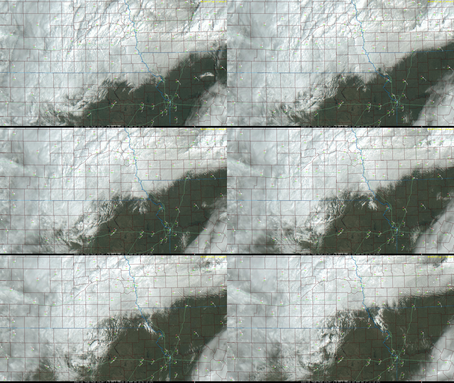
This warm front that you can clearly see on visible satellite on the image below is pushing north/northeast currently (you can see the roughly east/west oriented boundary with the clouds forming between Falls City and Nebraska City currently...and by looking at the wind directions) will be the focus for strong/severe storms - some of which could be tornadic this afternoon.
Along and south of this warm front, relatively warm and muggy air exists. With the helicity values, 0-1km shear and ESRH as high as they are, supercells are likely with the potential for tornadoes. People from just south of Omaha up toward Des Moines need to pay close attention over the next few hours as it will depend how quickly storms form if they end up effecting anywhere in our local area. Otherwise parts of Central and eastern IA in particular look dangerous later today.
...it's also worth noting how obvious the exact location of the low pressure is on this map by watching the spin of the clouds (and again by looking at the wind direction). It's near York/Columbus currently and will likely pass extremely close to Omaha itself in a couple hours...
I just know June is our main month for the real stuff. Id be disappointed if we didnt see any excitement in May though. As of right now I've experienced a pretty darn good lightning storm, and last Saturday's popup hail and lightning srorm, but nothing too exciting yet. I'll wait for storm chaser to chime in, as I haven't really done research. All I recall is my storm chaser friend say something about something that might mean theres a better chance for severe weather around here this year.
Omaha Cowboy wrote: Fri May 01, 2020 8:30 am
Well, we’re now at May 1st..heading right into the heart of severe Spring weather season..
Anyone care to gaze into the crystal ball and predict what kind of severe spring weather the Omaha metro area might expect?...
Ciao..LiO...Peace
Weird year. I saw a post from a Wichita TV met that this is the sixth-longest that KS has gone in a given year without a tornado. Fifth-longest was 2018. So maybe we're in a period.
But 2008 got started late. I always set my eyes on the six-week period beginning 1 May, with the maxima on Mem Day weekend. Past two years, I've gotten my feelings hurt...:-)
CNN wrote:The preliminary count of 351 tornadoes last month is the second most for any April on record, according to the National Weather Service Storm Prediction Center. All but three days in April had official reports of severe weather.
"There is a chance for strong to possibly severe storms this afternoon and evening across portions of eastern Nebraska and western Iowa. Large hail and strong wind gusts would be the primary hazards but an isolated tornado cannot be ruled out.
Storms may begin to form after noon across southeast Nebraska and quickly spread northeast along a warm front. Any storms that do develop near this front could be strong to severe.
"Spotter activation could be needed this afternoon"
I'm coming to expect something fun today as the forecast has steadily remained at a 60% + chance throughout the week leading up to today. That doesnt happen too often. Maybe some fun lightning, small hail, gusty winds and mildly interesting looking clouds. And sounds like it'll take that traditional southwest to northeast route.
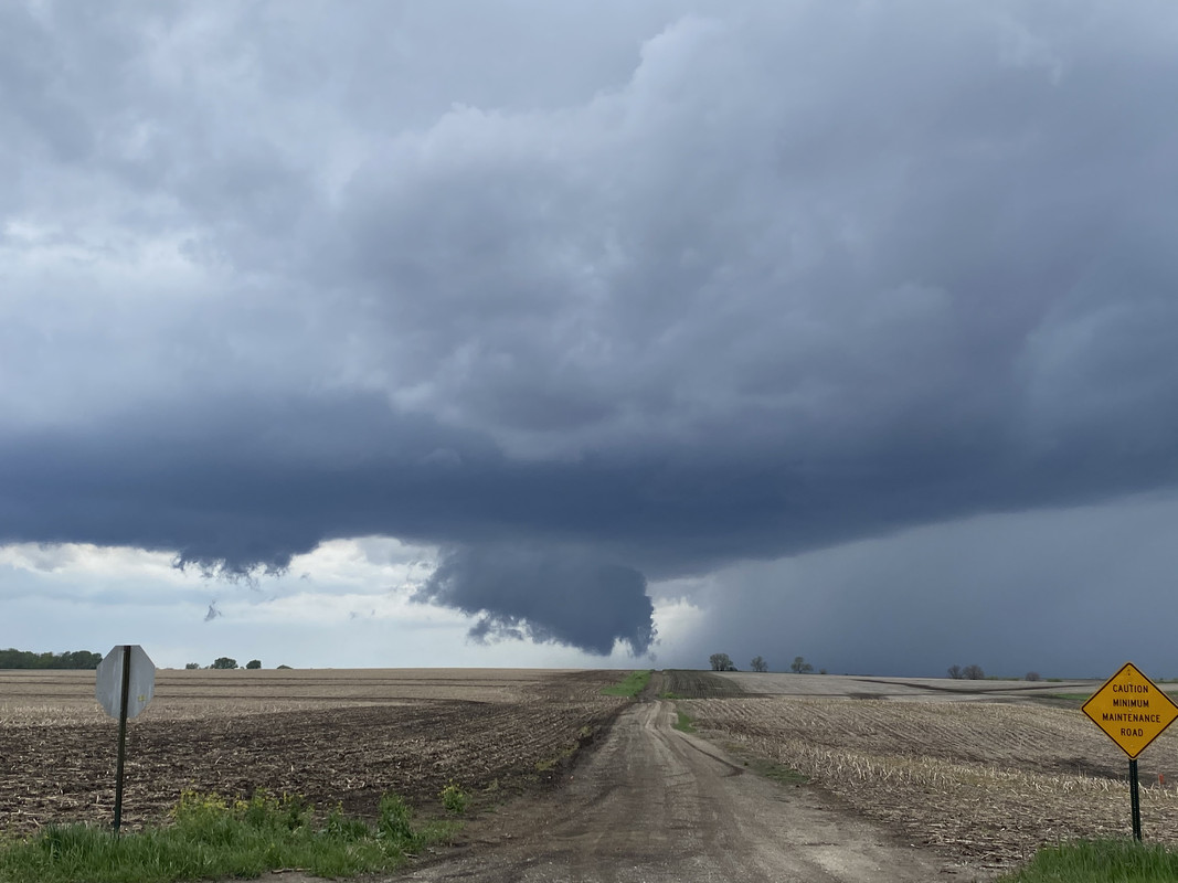
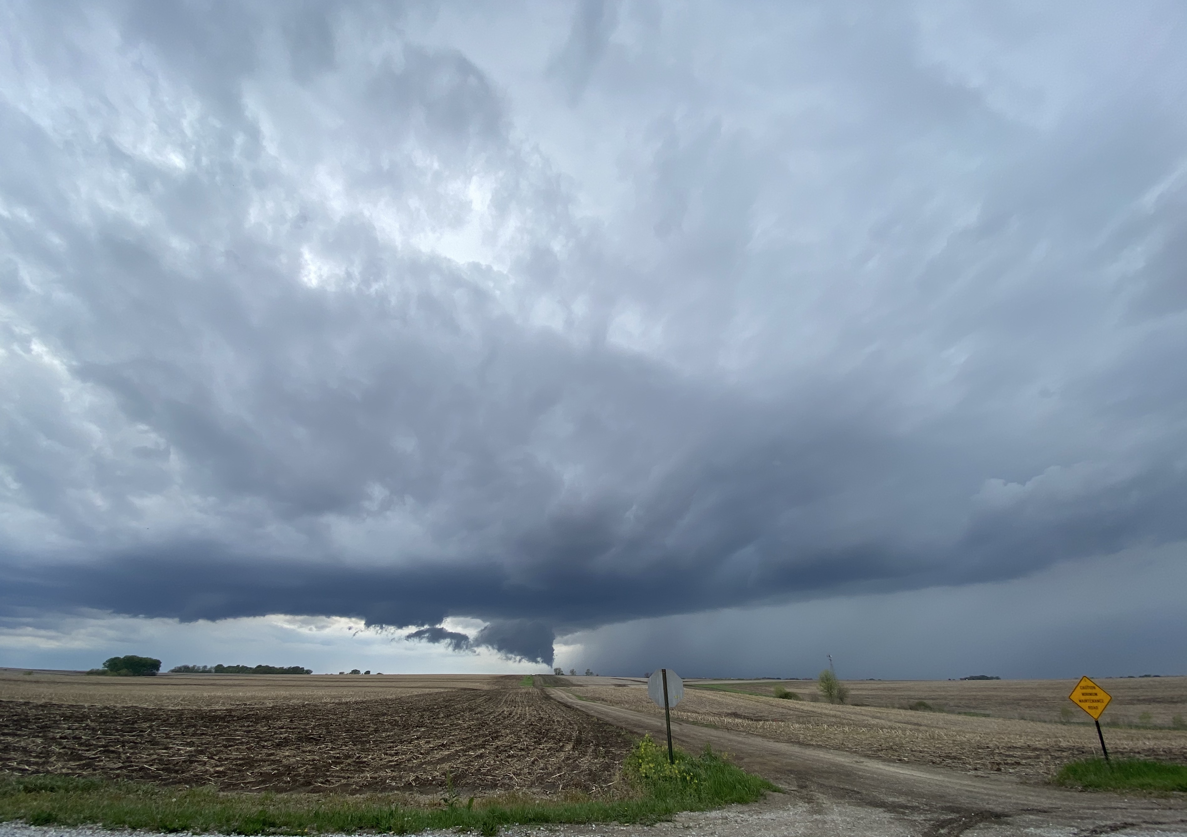
Got on the “storm of the day” just as it developed as I noticed in the morning potential for a tornadic storm later in the day nearby. It first fired east of Lincoln and then quickly embedded itself on the warm front and started to rotate. It came very close to producing tornadoes several times but ultimately the storm was just slightly too outflow dominant and the wall clouds kept getting undercut by rain cooled air before cycling up and trying again. Saw several funnels west of Avoca (pictured below) and as the storm tracked toward Plattsmouth. Ultimately a very photogenic storm though and fun local chase...
Wide angle showing overall structure...
Last edited by stormchaser on Sun May 17, 2020 11:40 am, edited 1 time in total.
Busguy2010 wrote: Sun May 17, 2020 10:52 am
Very cool it seems like we've had these little teaser tornado warnings right outside of town pretty often the last three years.
Yep, probably due in part to a theory (that’s nearly impossible to prove but plausible). It’s known as the “heat Island effect” - basically because larger cities have a significant amounts of blacktop roads, roofs, darker surfaces, etc the temp is typically a few degrees warmer in the city as opposed to outside of the city. Consequently a radius around a city there is a temperature boundary that can form and further enhance helicity/rotation/forcing if storms “embed” on that boundary - which in this case was basically the same area the warm front pushed into but possible the heat island played a roll with this event (and past events too)...
stormchaser wrote: Sun May 17, 2020 11:47 am
Yep, probably due in part to a theory (that’s nearly impossible to prove but plausible). It’s known as the “heat Island effect” - basically because larger cities have a significant amounts of blacktop roads, roofs, darker surfaces, etc the temp is typically a few degrees warmer in the city as opposed to outside of the city. Consequently a radius around a city there is a temperature boundary that can form and further enhance helicity/rotation/forcing if storms “embed” on that boundary - which in this case was basically the same area the warm front pushed into but possible the heat island played a roll with this event (and past events too)...
If I recall correctly, there has been a bunch of small-change "tornadoes" the last few years around cities that are pretty much the next towns outside of Omaha. I think this is the second one for Plattsmouth recently, Fremont, Fort Calhoun, some of the cities right outside CB. But we haven't had a big daddy supercell roll through in a long time.
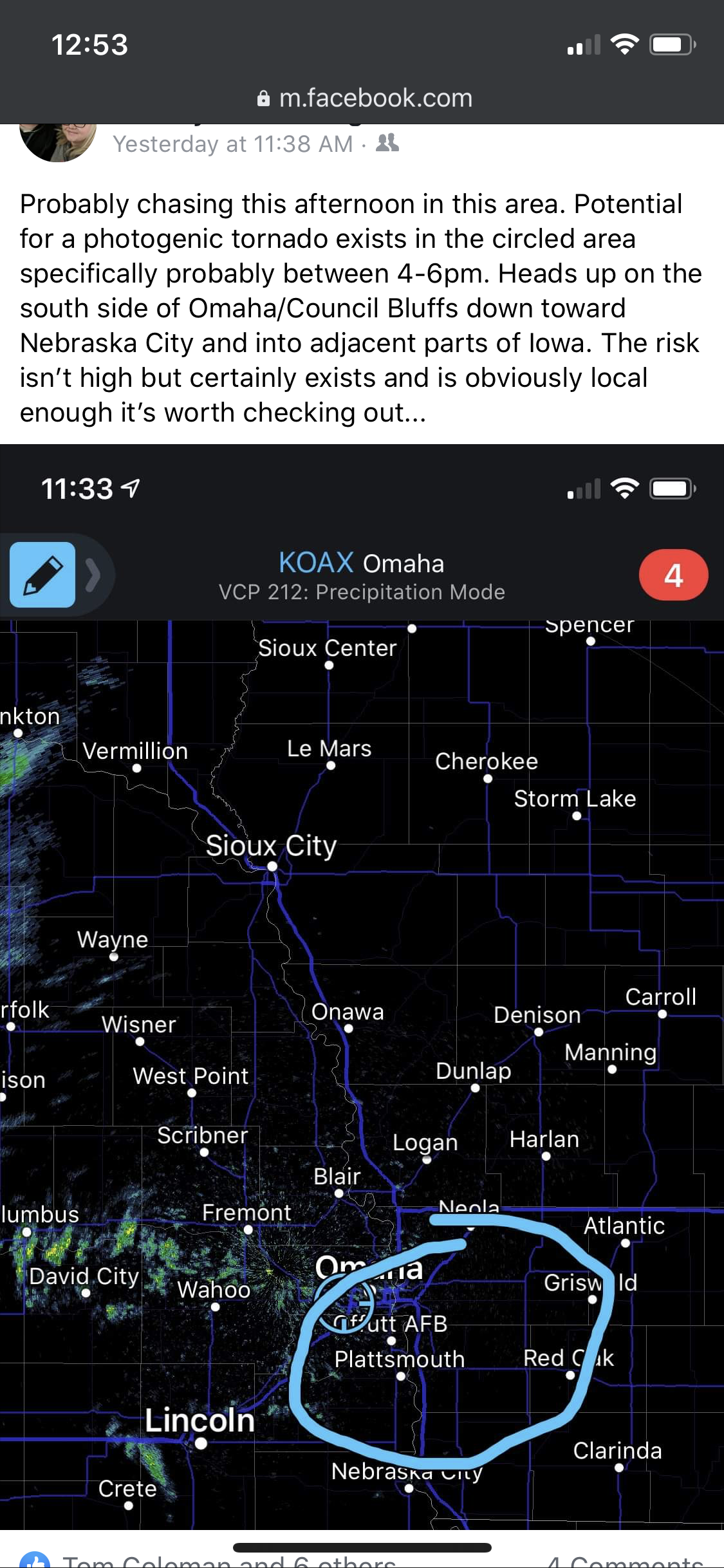
For what it’s worth (which I realize isn’t probably a lot) my forecast I posted on FB ended up being pretty accurate about 6 hours prior to the storm occurring...










 it seems like we've had these little teaser tornado warnings right outside of town pretty often the last three years.