2020 Weather Thread
-
stormchaser

- Planning Board
- Posts: 2380
- Joined: Fri Jun 01, 2018 8:14 am
Re: 2020 Severe Weather Thread
Wouldn't be shocked to see an isolated stronger storm in the Omaha area this afternoon - possibly a few severe warned for hail but shouldn't be anything too crazy.
-
skinzfan23

- City Council
- Posts: 11620
- Joined: Mon Feb 09, 2004 11:26 am
- Location: Omaha/Bellevue
Re: 2020 Severe Weather Thread
I don't have a rain gauge and I know that this past weekend's thunderstorms fell apart for the Omaha metro area, but the past 3-4 days, when the local weathermen were adamant that most everyone would get 2-3 in of rain was way off. I am glad that none of the severe weather ended up over Omaha, but in Bellevue, I think we got less than .5 in and that was from the rain on Thursday. I watch the weather pretty closely to know if I need to water the yard or garden but we definitely could use some rain in Bellevue.
-
NUub
- Library Board
- Posts: 331
- Joined: Sun May 17, 2020 9:58 pm
Re: 2020 Severe Weather Thread
A decent line up by Norfolk on the move to the southeast. Hilarious that what was essentially not forecast might give us a decent shot at rain compared to yesterday, as they'd reach us well before the sun gets low.
-
stormchaser
- Planning Board
- Posts: 2380
- Joined: Fri Jun 01, 2018 8:14 am
Re: 2020 Severe Weather Thread
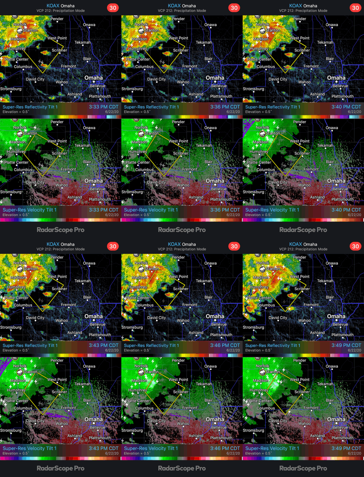
Yep, gotta love 2020. Forecast models really didn't pick up on this at all until a couple hours ago (which is when I mentioned the potential)...Dumb storms.NUub wrote: Mon Jun 22, 2020 2:58 pm A decent line up by Norfolk on the move to the southeast. Hilarious that what was essentially not forecast might give us a decent shot at rain compared to yesterday, as they'd reach us well before the sun gets low.
-
stormchaser
- Planning Board
- Posts: 2380
- Joined: Fri Jun 01, 2018 8:14 am
Re: 2020 Severe Weather Thread
Severe thunderstorm northwest of Omaha - may be here in time for rush hour with some damaging wind...
-
NUub
- Library Board
- Posts: 331
- Joined: Sun May 17, 2020 9:58 pm
Re: 2020 Severe Weather Thread
-Sound of failing Millennium Falcon hyperdrive-
-
Omaha Cowboy

- The Don
- Posts: 1013711
- Joined: Wed Jan 07, 2004 5:31 am
- Location: West Omaha
 ...
...-
stormchaser
- Planning Board
- Posts: 2380
- Joined: Fri Jun 01, 2018 8:14 am
Re: 2020 Severe Weather Thread
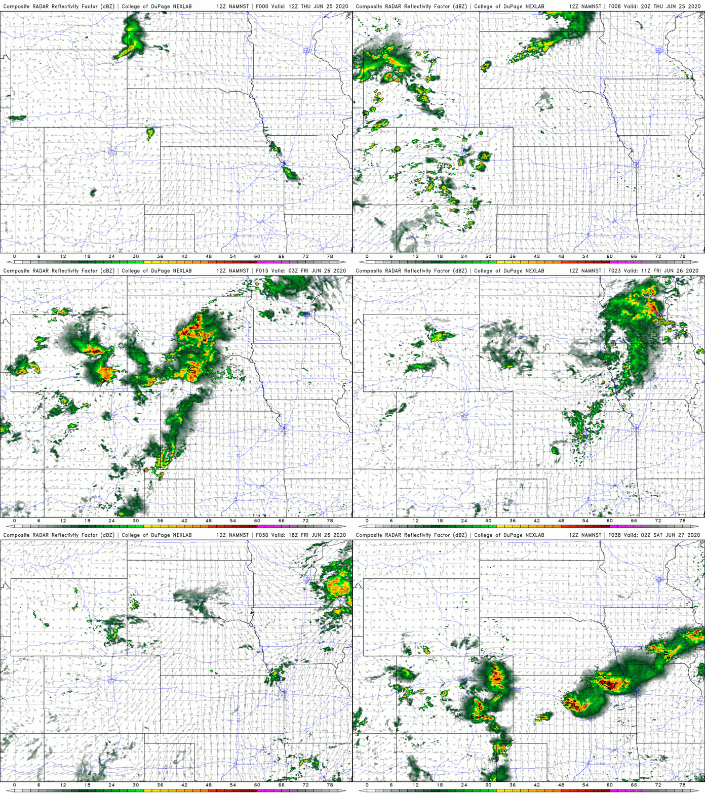
Looks like some showers and thunderstorms will push through the Omaha area late tonight (after midnight probably) with additional storms developing along a front tomorrow in parts of Iowa down into far southeastern NE (southeast of Omaha). These storms will include a damaging wind/hail threat...
Below is the simulated radar from the 12z 3km NAM forecast model showing the rain pushing through our area and then the storm redevelopment:
Below is the simulated radar from the 12z 3km NAM forecast model showing the rain pushing through our area and then the storm redevelopment:
-
Omaha Cowboy
- The Don
- Posts: 1013711
- Joined: Wed Jan 07, 2004 5:31 am
- Location: West Omaha
Re: 2020 Severe Weather Thread
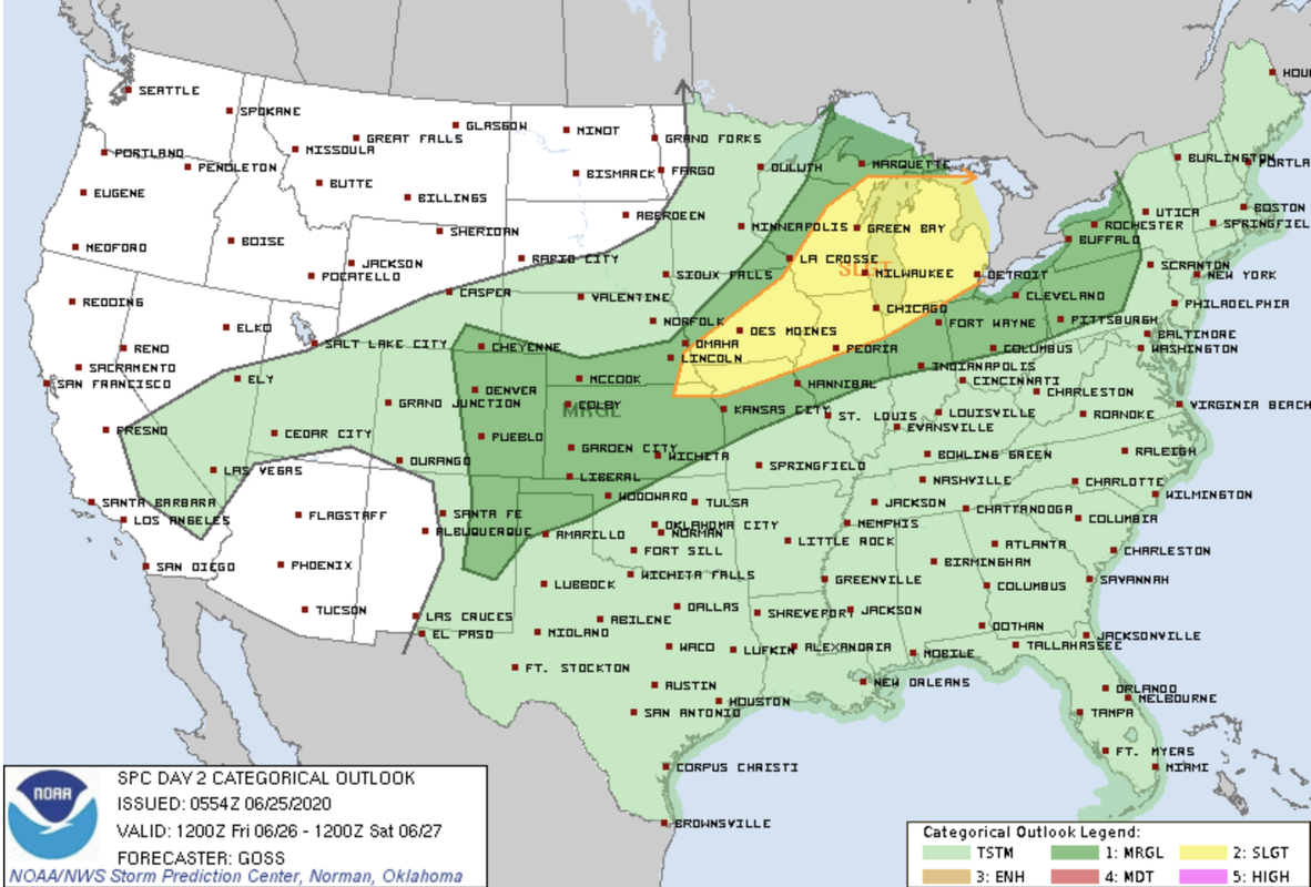
Interesting. I think I saw the Omaha area was in the “Slight Risk” category for severe storms for this Friday...
Ciao..LiO...Peace
Ciao..LiO...Peace
Go Cowboys!
-
nebugeater

- City Council
- Posts: 110920
- Joined: Wed Aug 04, 2004 6:07 pm
- Location: Gretna NE
Re: 2020 Severe Weather Thread
Well, it is not a Forcast but I drove through some HEAVY rain this morning between where I get on I 80 at 432 exit (outlet mall) and exit 442 ( Cabela's) It was varying but for about 1/2 of it it was intense enough that my wipers on high didn't make visibility that great. I left Gretna about 5:10 AM. The rest of my drive was basically no rain.
For the record NEBUGEATER does not equal BUGEATER !!!!!!!
-
stormchaser
- Planning Board
- Posts: 2380
- Joined: Fri Jun 01, 2018 8:14 am
Re: 2020 Severe Weather Thread
Sounds like funnebugeater wrote: Thu Jun 25, 2020 11:18 am Well, it is not a Forcast but I drove through some HEAVY rain this morning between where I get on I 80 at 432 exit (outlet mall) and exit 442 ( Cabela's) It was varying but for about 1/2 of it it was intense enough that my wipers on high didn't make visibility that great. I left Gretna about 5:10 AM. The rest of my drive was basically no rain.

Yep, well technically for just south and east of town but it depends on timing of exactly when the front pushes through. If it slows down at all (which is certainly possible still), the Omaha area itself would be at risk for damaging wind/hail.Omaha Cowboy wrote: Thu Jun 25, 2020 10:38 am Interesting. I think I saw the Omaha area was in the “Slight Risk” category for severe storms for this Friday...
Ciao..LiO...Peace
-
NUub
- Library Board
- Posts: 331
- Joined: Sun May 17, 2020 9:58 pm
Re: 2020 Severe Weather Thread
Was it a rental? I can't stand driving thru rain with an untreated windshield. Usually just waxing it with the same stuff as the paint is good enough, don't even need windshield wipers over 30mph.nebugeater wrote: Thu Jun 25, 2020 11:18 am Well, it is not a Forcast but I drove through some HEAVY rain this morning between where I get on I 80 at 432 exit (outlet mall) and exit 442 ( Cabela's) It was varying but for about 1/2 of it it was intense enough that my wipers on high didn't make visibility that great. I left Gretna about 5:10 AM. The rest of my drive was basically no rain.
-
Busguy2010

- City Council
- Posts: 7322
- Joined: Sat Apr 09, 2011 7:32 pm
- Location: North Central Omaha
Re: 2020 Severe Weather Thread
Yeah, after watching Bill Randby last night, I felt pretty good about leaving my clothes out to dry last night (cause he said 10% chance of rain kind of in a joking "only cause I have to" kind of way) only to wake up some time around 5 to a torrential (albeit fairly brief) rain. Bottom line is he did warn me and it did pass fairly quickly (but 5 min of heavy rain is 5 min of heavy rain) and my clothes still dried nonetheless. It was just a bit of a surprise.nebugeater wrote: Thu Jun 25, 2020 11:18 am Well, it is not a Forcast but I drove through some HEAVY rain this morning between where I get on I 80 at 432 exit (outlet mall) and exit 442 ( Cabela's) It was varying but for about 1/2 of it it was intense enough that my wipers on high didn't make visibility that great. I left Gretna about 5:10 AM. The rest of my drive was basically no rain.
-
Omaha Cowboy
- The Don
- Posts: 1013711
- Joined: Wed Jan 07, 2004 5:31 am
- Location: West Omaha
Re: 2020 Severe Weather Thread
Well, from where I sit, it looks pretty much for sure that Omaha’s most active severe weather month will pass and really be pretty much uneventful. The only day was 6/9 when there was a Tornado Watch issued and strong storms moved in..which knocked power out in my neighborhood for 2 hours. Other than that, June looks like it will go out just like it came in- like a lamb..
By the way, is it just me or did June overall feel much warmer than usual? I know this past May felt much cooler than normal, but it seems like for perhaps more than half of June, Omaha had high temps of 90 or above...
Ciao..LiO...Peace
By the way, is it just me or did June overall feel much warmer than usual? I know this past May felt much cooler than normal, but it seems like for perhaps more than half of June, Omaha had high temps of 90 or above...
Ciao..LiO...Peace
Go Cowboys!
-
stormchaser
- Planning Board
- Posts: 2380
- Joined: Fri Jun 01, 2018 8:14 am
Re: 2020 Severe Weather Thread
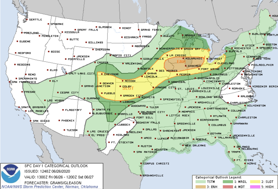
The SPC has shifted the severe weather risk ever so slightly west and north so it now includes the Lincoln/Omaha areas (though barely). Regardless, storm development this afternoon into this evening will likely be close but probably still south and east of town. Potential storm. mode now seems more super cellular than before. Hail and damaging wind will be the primary threats but there is a low risk for a tornado or 2 with these storms as well.
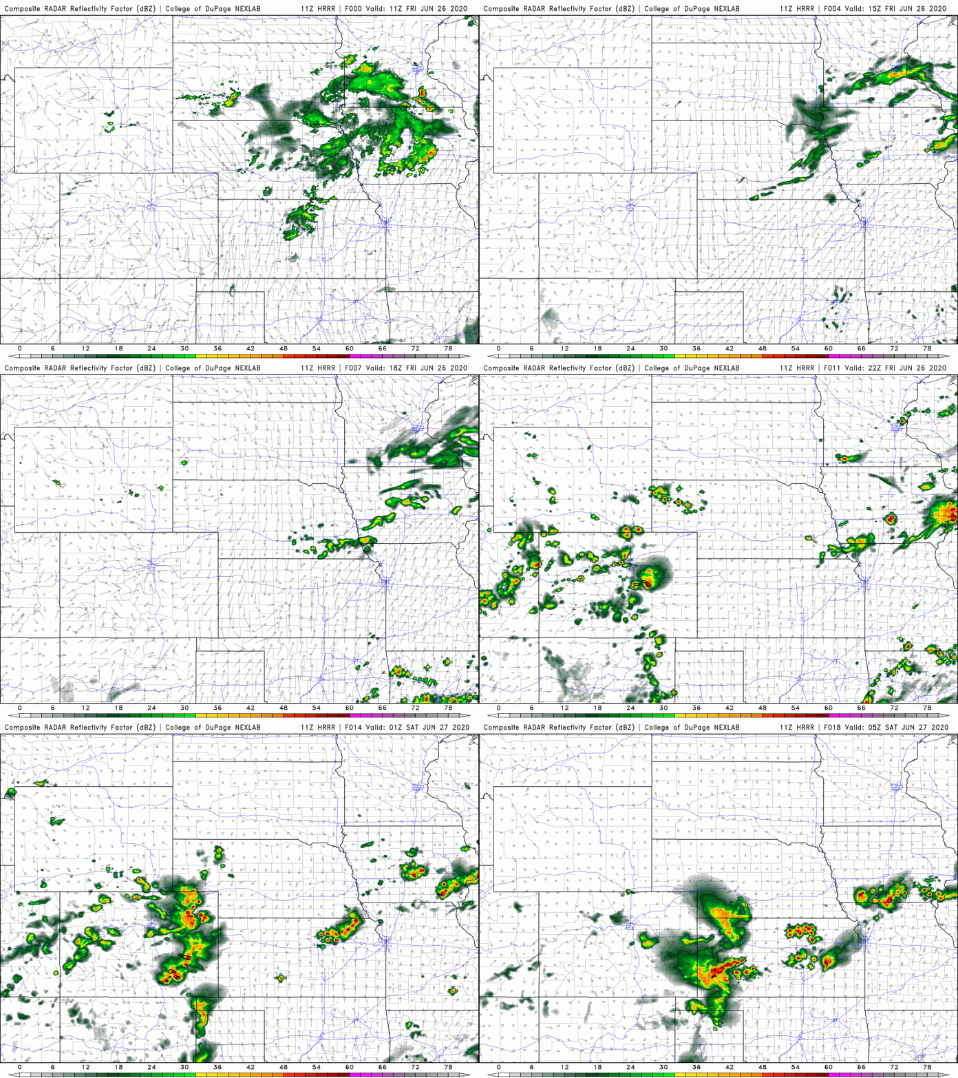
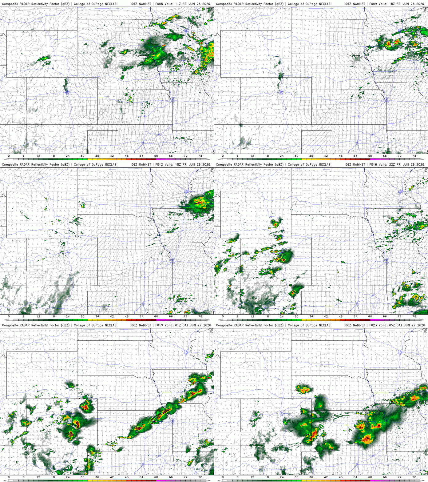
Model guidance continues to struggle (just like it has as of late) with significant differences between the current HRRR forecast model (which favors more of a supercellular mode) and the 3km NAM which favors more of a MCS storm mode with much of the activity further south and east. Just one of those things that can make knowing what to expect that much more difficult. I would expect what really happens will be a combination of both.
Here is the simulated radar from 11z HRRR (for now until approx midnight tonight):
Here is the simulated radar from the 06z 3km NAM for the exact same time frame:
Model guidance continues to struggle (just like it has as of late) with significant differences between the current HRRR forecast model (which favors more of a supercellular mode) and the 3km NAM which favors more of a MCS storm mode with much of the activity further south and east. Just one of those things that can make knowing what to expect that much more difficult. I would expect what really happens will be a combination of both.
Here is the simulated radar from 11z HRRR (for now until approx midnight tonight):
Here is the simulated radar from the 06z 3km NAM for the exact same time frame:
-
Omaha Cowboy
- The Don
- Posts: 1013711
- Joined: Wed Jan 07, 2004 5:31 am
- Location: West Omaha
Re: 2020 Severe Weather Thread
Perhaps we’ll get some action after all...
Ciao..LiO...Peace
Ciao..LiO...Peace
Go Cowboys!
-
Busguy2010
- City Council
- Posts: 7322
- Joined: Sat Apr 09, 2011 7:32 pm
- Location: North Central Omaha
Re: 2020 Severe Weather Thread
It felt more like a normal July if you ask me.Omaha Cowboy wrote: Fri Jun 26, 2020 7:29 am Well, from where I sit, it looks pretty much for sure that Omaha’s most active severe weather month will pass and really be pretty much uneventful. The only day was 6/9 when there was a Tornado Watch issued and strong storms moved in..which knocked power out in my neighborhood for 2 hours. Other than that, June looks like it will go out just like it came in- like a lamb..
By the way, is it just me or did June overall feel much warmer than usual? I know this past May felt much cooler than normal, but it seems like for perhaps more than half of June, Omaha had high temps of 90 or above...
Ciao..LiO...Peace
-
Busguy2010
- City Council
- Posts: 7322
- Joined: Sat Apr 09, 2011 7:32 pm
- Location: North Central Omaha
Re: 2020 Severe Weather Thread
Still only a 30% chance though, so I won't be getting very excited.
-
stormchaser
- Planning Board
- Posts: 2380
- Joined: Fri Jun 01, 2018 8:14 am
Re: 2020 Severe Weather Thread
Cold front is pushing through Omaha currently. Any storms should occur either east or south of town from here on out (once the front is fully through within the next 30 minutes or so)
-
Omaha Cowboy
- The Don
- Posts: 1013711
- Joined: Wed Jan 07, 2004 5:31 am
- Location: West Omaha
Re: 2020 Severe Weather Thread
I would agree. Most of June felt like July.. Much of May felt like mid March...Busguy2010 wrote: Fri Jun 26, 2020 11:26 amIt felt more like a normal July if you ask me.Omaha Cowboy wrote: Fri Jun 26, 2020 7:29 am Well, from where I sit, it looks pretty much for sure that Omaha’s most active severe weather month will pass and really be pretty much uneventful. The only day was 6/9 when there was a Tornado Watch issued and strong storms moved in..which knocked power out in my neighborhood for 2 hours. Other than that, June looks like it will go out just like it came in- like a lamb..
By the way, is it just me or did June overall feel much warmer than usual? I know this past May felt much cooler than normal, but it seems like for perhaps more than half of June, Omaha had high temps of 90 or above...
Ciao..LiO...Peace
Ciao..LiO...Peace
Go Cowboys!
-
stormchaser
- Planning Board
- Posts: 2380
- Joined: Fri Jun 01, 2018 8:14 am
Re: 2020 Severe Weather Thread
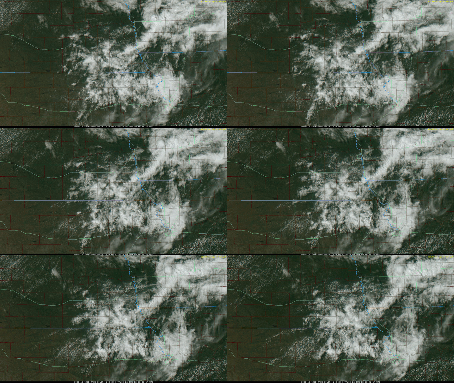
It will be interesting if anything can get going just south of Omaha in the next couple hours along this east/west boundary (near Ashland currently and east/west from there). It appears to be trying on the visible satellite anyway. Shear values are pretty marginal but it wouldn't shock me if a storm fires nearby (albeit mostly south of town) soon. Something to keep an eye on - especially if you live on the south side of town. Of course odds are low though that a storm will fire and be able to sustain itself...

Visible satellite showing cumulus trying to tower along the same boundary just south of Omaha.
Visible satellite showing cumulus trying to tower along the same boundary just south of Omaha.
-
stormchaser
- Planning Board
- Posts: 2380
- Joined: Fri Jun 01, 2018 8:14 am
Re: 2020 Severe Weather Thread
Decent threat for damaging hail not far from Omaha tomorrow morning (Sunday) with potential for tornadoes East/northeast of Omaha in western/northern IA during the afternoon/evening- though potential still could shift west and include Omaha too. Regardless could be an interesting day in the area at least...
-
Omaha Cowboy
- The Don
- Posts: 1013711
- Joined: Wed Jan 07, 2004 5:31 am
- Location: West Omaha
Re: 2020 Severe Weather Thread
Sounds like things could get interesting throughout the day in the Omaha area...stormchaser wrote: Sat Jun 27, 2020 5:41 pm Decent threat for damaging hail not far from Omaha tomorrow morning (Sunday) with potential for tornadoes East/northeast of Omaha in western/northern IA during the afternoon/evening- though potential still could shift west and include Omaha too. Regardless could be an interesting day in the area at least...
Ciao..LiO...Peace
Go Cowboys!
-
stormchaser
- Planning Board
- Posts: 2380
- Joined: Fri Jun 01, 2018 8:14 am
Re: 2020 Severe Weather Thread
The SPC has shifted the slight risk today to include Omaha itself (albeit barely). As expected, most of the risk today should end up north/northeast of Omaha with Omaha itself probably “capped”.
Severe outlook for today: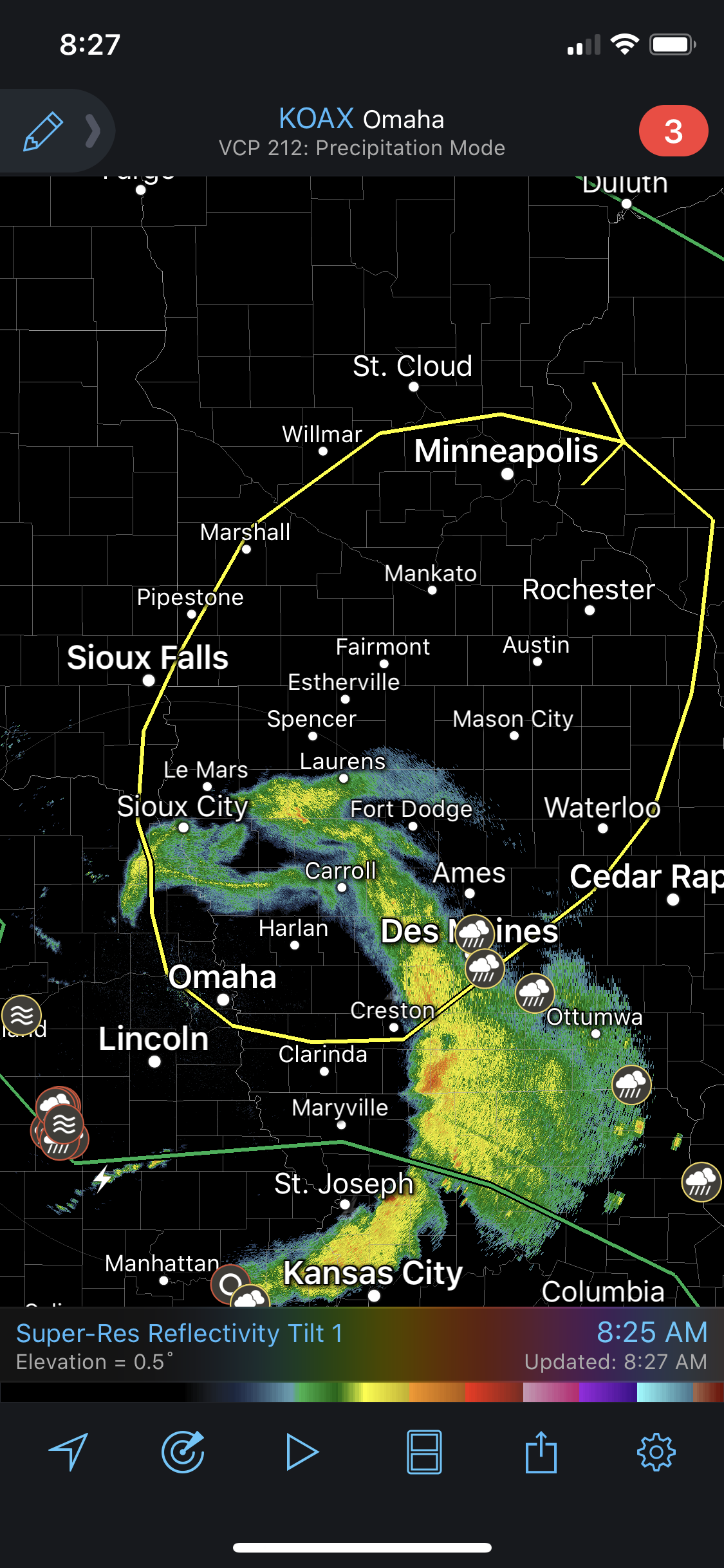
Tornado risk:
Severe outlook for today:
Tornado risk:
-
Busguy2010
- City Council
- Posts: 7322
- Joined: Sat Apr 09, 2011 7:32 pm
- Location: North Central Omaha
Re: 2020 Severe Weather Thread
In case you missed it, there were severe thunderstorm warnings not too far to our south with the storms that happened around 4 something this morning.
-
stormchaser
- Planning Board
- Posts: 2380
- Joined: Fri Jun 01, 2018 8:14 am
Re: 2020 Severe Weather Thread
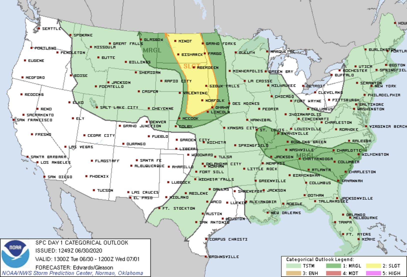
Strong/severe storms are possible later today in parts of eastern Nebraska (mostly west of Omaha but possibly in Omaha tonight too). Damaging wind and hail will be the main threats with these storms but as always, an isolated tornado is also possible.
-
Busguy2010
- City Council
- Posts: 7322
- Joined: Sat Apr 09, 2011 7:32 pm
- Location: North Central Omaha
Re: 2020 Severe Weather Thread
Gee what a surprise, another overnight threat. Practically everything that could be considered resembling exciting has been overnight.
-
stormchaser
- Planning Board
- Posts: 2380
- Joined: Fri Jun 01, 2018 8:14 am
Re: 2020 Severe Weather Thread
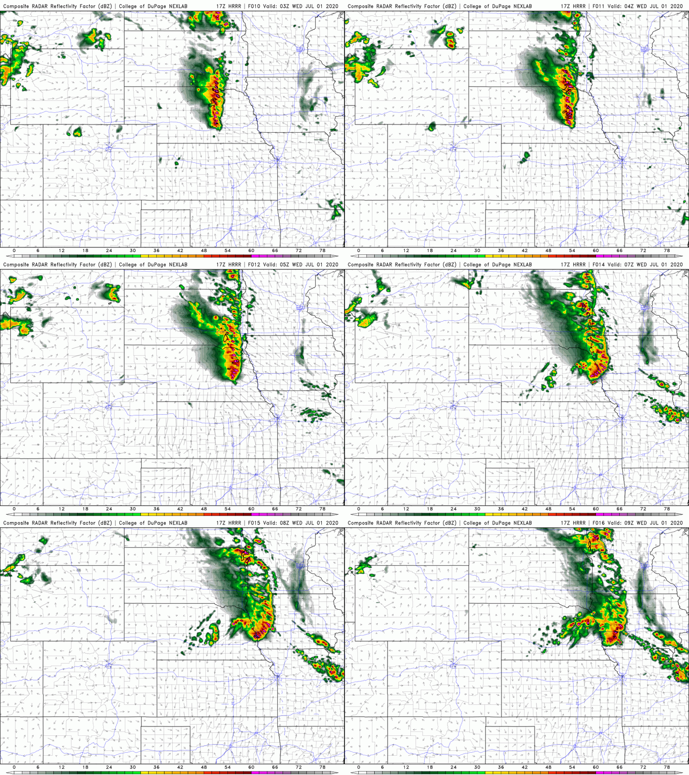
Yep, gotta love it. Looking like a fairly significant damaging wind event in the area in or just north/northwest of Omaha tonight. Wouldn't be surprised to see reports of 70-80mph+ winds...Busguy2010 wrote: Tue Jun 30, 2020 12:24 pm Gee what a surprise, another overnight threat. Practically everything that could be considered resembling exciting has been overnight.
-
NUub
- Library Board
- Posts: 331
- Joined: Sun May 17, 2020 9:58 pm
Re: 2020 Severe Weather Thread
Will be interesting to see if this one materializes. Some times when you get into the summer season, seems like it is so difficult to accurately predict any storm event.
-
stormchaser
- Planning Board
- Posts: 2380
- Joined: Fri Jun 01, 2018 8:14 am
Re: 2020 Severe Weather Thread
Yep, if anything happens in the local area, it probably won't be until at least Midnight...NUub wrote: Tue Jun 30, 2020 2:54 pm Will be interesting to see if this one materializes. Some times when you get into the summer season, seems like it is so difficult to accurately predict any storm event.
-
NUub
- Library Board
- Posts: 331
- Joined: Sun May 17, 2020 9:58 pm
Re: 2020 Severe Weather Thread
Seems like our overnight chances have gone up in the short term. May be looking at something coming thru after 1AM. Even KETV is throwing the 80% number around in the forecast.
-
Omaha Cowboy
- The Don
- Posts: 1013711
- Joined: Wed Jan 07, 2004 5:31 am
- Location: West Omaha
Re: 2020 Severe Weather Thread
I see much of Douglas County is also included in the Slight Risk category for strong to severe thunderstorms tonight into overnight..
One thing’s for certain, we could use a good soaking rain. Overnight tonight might be our best chance to get one for the next 7 days...
Ciao..LiO...Peace
One thing’s for certain, we could use a good soaking rain. Overnight tonight might be our best chance to get one for the next 7 days...
Ciao..LiO...Peace
Go Cowboys!
-
Busguy2010
- City Council
- Posts: 7322
- Joined: Sat Apr 09, 2011 7:32 pm
- Location: North Central Omaha
Re: 2020 Severe Weather Thread
Yeah they did go up. At noon they were saying 4 am, now the NWS has also moved it a bit earlier to 1 am as well as bumped it up to 100%. And predicting over an inch of rain. I can deal with 1 am, that's not too late for me.NUub wrote: Tue Jun 30, 2020 5:17 pm Seems like our overnight chances have gone up in the short term. May be looking at something coming thru after 1AM. Even KETV is throwing the 80% number around in the forecast.
-
Brad

- Photographer
- Posts: 1036525
- Joined: Sat Feb 28, 2004 6:03 pm
- Location: Omaha, NE
Re: 2020 Severe Weather Thread
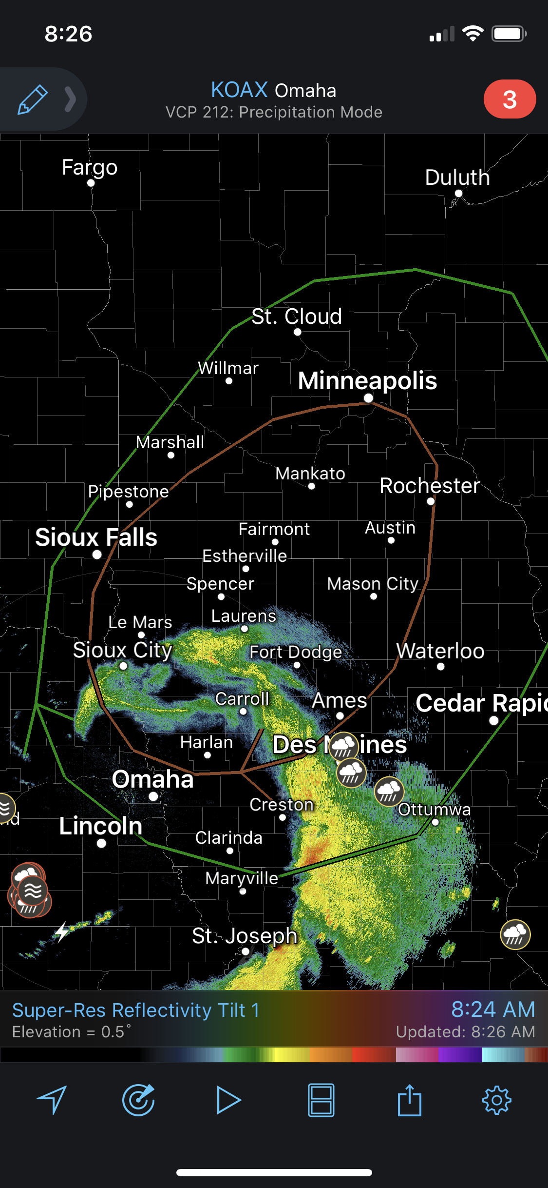
Nearly 80 mph winds indicated on Radar out near Columbus right now. Quite the line heading this way if it holds together.

Omaha Skyline Photos, Omaha Aerial Photos, and More.
Website: www.bradwilliamsphotography.com
Facebook: www.facebook.com/bradwilliamsphotography
Twitter: www.twitter.com/bradwphoto
Instagram: www.instagram.com/bradwilliamsphotography
YouTube: www.youtube.com/@bradwilliamsphoto
-
Busguy2010
- City Council
- Posts: 7322
- Joined: Sat Apr 09, 2011 7:32 pm
- Location: North Central Omaha
Re: 2020 Severe Weather Thread
looks like we are next. If it holds together, we will be under a severe thunderstorm warning before long.
-
Busguy2010
- City Council
- Posts: 7322
- Joined: Sat Apr 09, 2011 7:32 pm
- Location: North Central Omaha
Re: 2020 Severe Weather Thread
And it is pushing in tight. The point of that thing is directly aimed at us.
-
Omaha Cowboy
- The Don
- Posts: 1013711
- Joined: Wed Jan 07, 2004 5:31 am
- Location: West Omaha
Re: 2020 Severe Weather Thread
Well, May/June 2020 came and went.. Perhaps the most boring severe weather season in recent history..
We’re now headed into the dog days of summer. Any early models indicate the chance for some active weather the next several weeks?...
Ciao..LiO...Peace
We’re now headed into the dog days of summer. Any early models indicate the chance for some active weather the next several weeks?...
Ciao..LiO...Peace
Go Cowboys!
-
Busguy2010
- City Council
- Posts: 7322
- Joined: Sat Apr 09, 2011 7:32 pm
- Location: North Central Omaha
Re: 2020 Severe Weather Thread
Hehe, we've been in the dog days for the last month as far as I'm concerned. The last day or two have been pretty comfortable, all things considered. I have no answer for your question, but Wednesday might bring something. Only about a month or so now and we will begin to see the seasons change, hard to believe. As a gardener, I always notice the shadows getting significantly longer about midway through August, and once you get through the first 10 days or so of August, you can almost bet the house the dog days are over (I'm sure you know this). I'm just getting excited for cooler patterns, that historically are only a little over a month away. YES!Omaha Cowboy wrote: Mon Jul 06, 2020 11:10 pm Well, May/June 2020 came and went.. Perhaps the most boring severe weather season in recent history..
We’re now headed into the dog days of summer. Any early models indicate the chance for some active weather the next several weeks?...
Ciao..LiO...Peace
-
Omaha Cowboy
- The Don
- Posts: 1013711
- Joined: Wed Jan 07, 2004 5:31 am
- Location: West Omaha
Re: 2020 Severe Weather Thread
Ha ha. Yes, those dog days seem to come in then exit out pretty quick. I enjoy summer, but my favorite weather temperature time of the year is in the fall. Specifically the last week of September all the way to the week leading to Thanksgiving (funny how that coincides with my love for football, lol).. Before “old man winter” settles in by the first week of December..Busguy2010 wrote: Tue Jul 07, 2020 12:13 amHehe, we've been in the dog days for the last month as far as I'm concerned. The last day or two have been pretty comfortable, all things considered. I have no answer for your question, but Wednesday might bring something. Only about a month or so now and we will begin to see the seasons change, hard to believe. As a gardener, I always notice the shadows getting significantly longer about midway through August, and once you get through the first 10 days or so of August, you can almost bet the house the dog days are over (I'm sure you know this). I'm just getting excited for cooler patterns, that historically are only a little over a month away. YES!Omaha Cowboy wrote: Mon Jul 06, 2020 11:10 pm Well, May/June 2020 came and went.. Perhaps the most boring severe weather season in recent history..
We’re now headed into the dog days of summer. Any early models indicate the chance for some active weather the next several weeks?...
Ciao..LiO...Peace
It’ll be interesting to see if the next 3 weeks of July bring any active weather beyond the usual summer rainstorms..not that I’m complaining, we need the rain too...
Ciao..LuO...Peace
Go Cowboys!
-
stormchaser
- Planning Board
- Posts: 2380
- Joined: Fri Jun 01, 2018 8:14 am
Re: 2020 Severe Weather Thread
Yep, very lame in our area this year so far. Always difficult to really know what to expect (as far as specifics anyway) more than a week out. Just so many things can change that will drastically change things. That being said, currently anyway it looks like next week may have a few days at least with tornado potential (lows/warm fronts/triple points) in our area roughly - depending on capping though which is normally an issue this time of year.Omaha Cowboy wrote: Mon Jul 06, 2020 11:10 pm Well, May/June 2020 came and went.. Perhaps the most boring severe weather season in recent history..
We’re now headed into the dog days of summer. Any early models indicate the chance for some active weather the next several weeks?...
Ciao..LiO...Peace
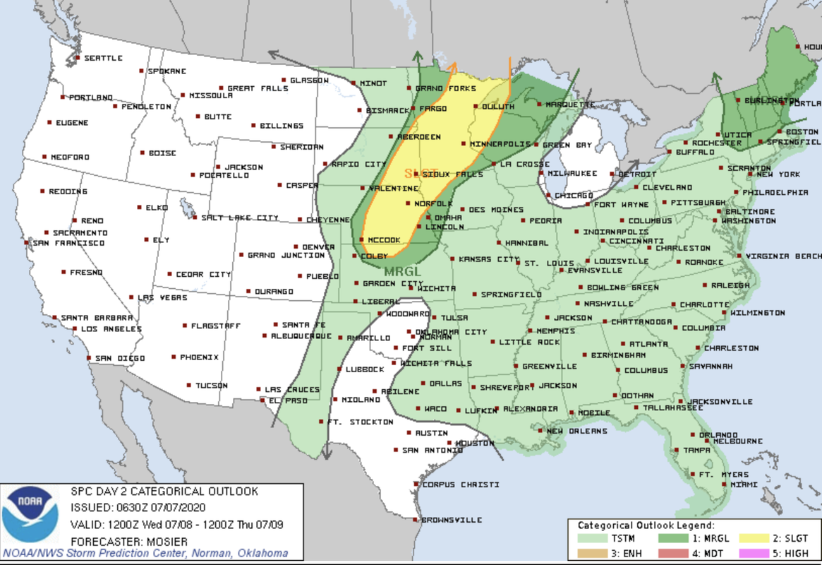
Anyhow, tomorrow looks like our next chance for severe weather in central/eastern Nebraska with the potential for a few tornadoes out toward the central part of the State (near Kearney roughly) and then a subsequent night time damaging wind event in eastern Nebraska (typical for July). SPC currently has an outlook for these areas for tomorrow though. I'd assume the risk will be extended further east to include the Lincoln/Omaha area too to account for the overnight storms.