2022 Weather Thread
-
Busguy2010
- City Council
- Posts: 7411
- Joined: Sun Apr 10, 2011 12:32 am
- Location: North Central Omaha
Re: 2022 Weather Thread
So Eppley recorded a 30, and I recorded a 31, so that indeed was our first freeze. Now the question is how far removed from this freeze will the next one be? Haven't been out to my garden yet, but I hope it was just brief enough that my several pounds of yet to ripen tomatoes survived. So if they did, and it will be a couple weeks til the next freeze, I might be in luck.
-
nativeomahan

- County Board
- Posts: 6051
- Joined: Fri Nov 12, 2004 8:46 pm
- Location: Omaha and Puerto Vallarta
Re: 2022 Weather Thread
I brought our tropical plants into the garage, but everything left outdoors survived, including our tomatoes and peppers. I did notice frost on our neighbor’s roof. My thermometer read 35f at 7 am.
-
Busguy2010
- City Council
- Posts: 7411
- Joined: Sun Apr 10, 2011 12:32 am
- Location: North Central Omaha
Re: 2022 Weather Thread
My tomatoes and peppers survived. So they will enjoy the next week of pretty warm weather. Next frost looks possible Thursday night/Friday morning.
-
BRoss

- IT Director
- Posts: 10003434
- Joined: Sat Aug 05, 2006 12:39 am
- Location: West Central Omaha
Re: 2022 Weather Thread
Out west, I didn't have it fall much below 35 according to my weather station.Busguy2010 wrote: Sat Oct 08, 2022 5:59 am Checking the forecast one last time before bed, it looks like the NWS is holding that Omaha will not get down to 32. Just barely, but the trend for today ended on it barely missing 32. Not that that matters, because for most of us, this will effectively be the first freeze whether we can record it or not. If in the morning my outdoor thermometer shows that it recorded a 32, I'll call it for my own records. October 8th would be the earliest since I've kept track in 2013.
-
Omaha Cowboy

- The Don
- Posts: 1013743
- Joined: Wed Jan 07, 2004 11:31 am
- Location: West Omaha
Re: 2022 Weather Thread
Agreed. In my neck of the woods in west Omaha, there was no freeze as temps only got down to 35-36 degrees. According to the forecast, we won’t see a hard 32 or below freeze for Omaha for at least the next 7 days..if not longer…BRoss wrote: Sun Oct 09, 2022 1:03 amOut west, I didn't have it fall much below 35 according to my weather station.Busguy2010 wrote: Sat Oct 08, 2022 5:59 am Checking the forecast one last time before bed, it looks like the NWS is holding that Omaha will not get down to 32. Just barely, but the trend for today ended on it barely missing 32. Not that that matters, because for most of us, this will effectively be the first freeze whether we can record it or not. If in the morning my outdoor thermometer shows that it recorded a 32, I'll call it for my own records. October 8th would be the earliest since I've kept track in 2013.
Ciao..LiO…Peace
Go Cowboys!
-
Busguy2010
- City Council
- Posts: 7411
- Joined: Sun Apr 10, 2011 12:32 am
- Location: North Central Omaha
Re: 2022 Weather Thread
It definitely froze. I live east of the Little Papio, and I definitely got down to 31, and Eppley reported 30. In fact, I checked all the airports within the OAX coverage area, and all of them reported lows no higher than 32, including the Millard Airport , which reported 31. I'm not saying your recordings are wrong, I'm saying they are probably outlying compared to most others.Omaha Cowboy wrote: Sun Oct 09, 2022 5:42 amAgreed. In my neck of the woods in west Omaha, there was no freeze as temps only got down to 35-36 degrees. According to the forecast, we won’t see a hard 32 or below freeze for Omaha for at least the next 7 days..if not longer…BRoss wrote: Sun Oct 09, 2022 1:03 am Out west, I didn't have it fall much below 35 according to my weather station.
-
Omaha Cowboy
- The Don
- Posts: 1013743
- Joined: Wed Jan 07, 2004 11:31 am
- Location: West Omaha
Re: 2022 Weather Thread
I honestly wish it would have froze in my neck of the woods in west Omaha. I was prepared for it. Guess I’ll need to wait a bit longer…Busguy2010 wrote: Sun Oct 09, 2022 7:25 amIt definitely froze. I live east of the Little Papio, and I definitely got down to 31, and Eppley reported 30. In fact, I checked all the airports within the OAX coverage area, and all of them reported lows no higher than 32, including the Millard Airport , which reported 31. I'm not saying your recordings are wrong, I'm saying they are probably outlying compared to most others.Omaha Cowboy wrote: Sun Oct 09, 2022 5:42 amAgreed. In my neck of the woods in west Omaha, there was no freeze as temps only got down to 35-36 degrees. According to the forecast, we won’t see a hard 32 or below freeze for Omaha for at least the next 7 days..if not longer…BRoss wrote: Sun Oct 09, 2022 1:03 am Out west, I didn't have it fall much below 35 according to my weather station.
Ciao..LiO…Peace
Go Cowboys!
-
Cermak
- Planning Board
- Posts: 2356
- Joined: Thu Nov 29, 2018 7:02 pm
Re: 2022 Weather Thread
We had frost on the grass in spots Saturday morning, my phone said 32. 114th and Center area.
-
Brad

- Photographer
- Posts: 1036722
- Joined: Sun Feb 29, 2004 12:03 am
- Location: Omaha, NE
Re: 2022 Weather Thread
Looking like we might get screwed on rain again tonight. Was looking decent on radar and then started to fall apart.

Omaha Skyline Photos, Omaha Aerial Photos, and More.
Website: www.bradwilliamsphotography.com
Facebook: www.facebook.com/bradwilliamsphotography
Twitter: www.twitter.com/bradwphoto
Instagram: www.instagram.com/bradwilliamsphotography
YouTube: www.youtube.com/@bradwilliamsphoto
-
Busguy2010
- City Council
- Posts: 7411
- Joined: Sun Apr 10, 2011 12:32 am
- Location: North Central Omaha
Re: 2022 Weather Thread
I think there's still a chance it could come back together. The front is still a decent distance NW of here and the NWS still has us at a 60% chance. Anyway they're talking about less than .1", so not like were missing much if it doesn't come through.
-
Brad
- Photographer
- Posts: 1036722
- Joined: Sun Feb 29, 2004 12:03 am
- Location: Omaha, NE
Re: 2022 Weather Thread
Wow, the radar came roaring back to life!
Omaha Skyline Photos, Omaha Aerial Photos, and More.
Website: www.bradwilliamsphotography.com
Facebook: www.facebook.com/bradwilliamsphotography
Twitter: www.twitter.com/bradwphoto
Instagram: www.instagram.com/bradwilliamsphotography
YouTube: www.youtube.com/@bradwilliamsphoto
-
Louie
- County Board
- Posts: 4975
- Joined: Fri Dec 23, 2011 10:23 pm
- Location: Dundee
Re: 2022 Weather Thread
Yeah were definitely gonna get some rain
-
Busguy2010
- City Council
- Posts: 7411
- Joined: Sun Apr 10, 2011 12:32 am
- Location: North Central Omaha
Re: 2022 Weather Thread
In the southwest part of town, I wouldnt be surprised if you got a little hail. Up north here, the radar looks pretty thin.
-
Busguy2010
- City Council
- Posts: 7411
- Joined: Sun Apr 10, 2011 12:32 am
- Location: North Central Omaha
Re: 2022 Weather Thread
Wow, I am getting some hail. Sounds like maybe dime-size. And a really decent rainfall. Quite a bit cooler now too.
-
skinzfan23
- City Council
- Posts: 11688
- Joined: Mon Feb 09, 2004 5:26 pm
- Location: Omaha/Bellevue
Re: 2022 Weather Thread
Wow that was nice to have a good old-fashioned thunderstorm. We had some small hail down in Bellevue, but with the strong winds, it sounded like much more.
As for rain, we actually got around 1.5", which is probably more than most of the metro, but the first significant rainfall in at least 3-4 weeks.
As for rain, we actually got around 1.5", which is probably more than most of the metro, but the first significant rainfall in at least 3-4 weeks.
-
Brad
- Photographer
- Posts: 1036722
- Joined: Sun Feb 29, 2004 12:03 am
- Location: Omaha, NE
Re: 2022 Weather Thread
Wow, we only go 0.44" at my place. We did get some hail too.skinzfan23 wrote: Wed Oct 12, 2022 1:55 pm Wow that was nice to have a good old-fashioned thunderstorm. We had some small hail down in Bellevue, but with the strong winds, it sounded like much more.
As for rain, we actually got around 1.5", which is probably more than most of the metro, but the first significant rainfall in at least 3-4 weeks.
Omaha Skyline Photos, Omaha Aerial Photos, and More.
Website: www.bradwilliamsphotography.com
Facebook: www.facebook.com/bradwilliamsphotography
Twitter: www.twitter.com/bradwphoto
Instagram: www.instagram.com/bradwilliamsphotography
YouTube: www.youtube.com/@bradwilliamsphoto
-
BRoss
- IT Director
- Posts: 10003434
- Joined: Sat Aug 05, 2006 12:39 am
- Location: West Central Omaha
Re: 2022 Weather Thread
Got 0.58" out around the Pepperwood area. Also had some hail too.
-
Busguy2010
- City Council
- Posts: 7411
- Joined: Sun Apr 10, 2011 12:32 am
- Location: North Central Omaha
Re: 2022 Weather Thread
Eppley reported .36". I feel like I got more than that, but I don't have confirmation. I'm kinda surprised we're still in a red flag warning despite the rain we got last night. But at the same time, I was also very surprised that although it was still raining at 2am last night, I woke up at 7am and I couldn't see any evidence of it. So it really must be that dry if it all evaporated that quick.
Looks like a couple sure bets for another freeze on Sunday/Monday/Tuesday.
Looks like a couple sure bets for another freeze on Sunday/Monday/Tuesday.
-
Omaha Cowboy
- The Don
- Posts: 1013743
- Joined: Wed Jan 07, 2004 11:31 am
- Location: West Omaha
Re: 2022 Weather Thread
Oddly, it was “nice” to have that good, old- fashioned string thunderstorm rumble through last night. Not a ton of moisture..But welcomed…Brad wrote: Wed Oct 12, 2022 1:58 pmWow, we only go 0.44" at my place. We did get some hail too.skinzfan23 wrote: Wed Oct 12, 2022 1:55 pm Wow that was nice to have a good old-fashioned thunderstorm. We had some small hail down in Bellevue, but with the strong winds, it sounded like much more.
As for rain, we actually got around 1.5", which is probably more than most of the metro, but the first significant rainfall in at least 3-4 weeks.
Ciao..LiO…Peace
Go Cowboys!
-
skinzfan23
- City Council
- Posts: 11688
- Joined: Mon Feb 09, 2004 5:26 pm
- Location: Omaha/Bellevue
Re: 2022 Weather Thread
On second thought, I am not sure that I got quite that much, I was recently out of town and didn't empty my rain gauge, some of that might have been from the sprinklers, either way it was nice to finally have some moisture.
-
almighty_tuna
- City Council
- Posts: 106420
- Joined: Tue Apr 13, 2004 6:34 pm
- Location: Somewhere between downtown and Colorado
Re: 2022 Weather Thread
Definitely an enjoyable thunderstorm to sit and watch the lightning, etc. My dog had other thoughts, however, but I can rest soundly knowing that I was well protected from the lightning and thunder.
-
stormchaser
- Planning Board
- Posts: 2380
- Joined: Fri Jun 01, 2018 1:14 pm
Re: 2022 Weather Thread
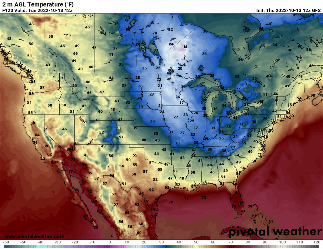
Looks like a pretty healthy shot of "cold" is on the horizon for early next week - our coldest temps so far anyway. Lows are depicted in the mid-upper 20s on both the GFS and ECMWF for our area Monday/Tuesday night (October 17th/18th) with a chance of flurries/very light snow currently depicted as close as southern MN into eastern Iowa...
This is the 12z GFS:
This is the 12z GFS:
-
Cermak
- Planning Board
- Posts: 2356
- Joined: Thu Nov 29, 2018 7:02 pm
Re: 2022 Weather Thread
A Hard freeze this morning. Pretty cold for mid October. Down to 18 , this is early for these temps. A lot of leaves falling off trees.
-
Busguy2010
- City Council
- Posts: 7411
- Joined: Sun Apr 10, 2011 12:32 am
- Location: North Central Omaha
Re: 2022 Weather Thread
I'm camping up by Valentine right now and it also got down to 18 here. I'm a bit surprised it's colder there than here. It seems like usually Western Nebraska gets colder earlier.
-
Louie
- County Board
- Posts: 4975
- Joined: Fri Dec 23, 2011 10:23 pm
- Location: Dundee
Re: 2022 Weather Thread
I think the main burst of this old air was centered more over the Mississippi and Ohio river valley. But in typical situations, I think you're definitely right, especially up north like Valentine.Busguy2010 wrote: Tue Oct 18, 2022 2:35 pm I'm camping up by Valentine right now and it also got down to 18 here. I'm a bit surprised it's colder there than here. It seems like usually Western Nebraska gets colder earlier.
-
stormchaser
- Planning Board
- Posts: 2380
- Joined: Fri Jun 01, 2018 1:14 pm
Re: 2022 Weather Thread
It's that time of year where we can get super cold temps (like we just had) and now potential for severe weather on the horizon late this upcoming weekend/early next week.
Some timing differences exist on the GFS and ECMWF so things could change but if things verify as shown, severe weather will be possible somewhere in our region (impossible to know if Omaha specifically) - including a threat for tornadoes. In fact, based on the 12z GFS, the tornado threat is relatively high from near Omaha up into northwest Iowa on Sunday (but again, things can and probably will change some).
Currently the SPC doesn't indicate a specific threat area because of the differences between models, but I'd expect them to start outlining areas at risk in future updates (or as models start to align better).
Something to be aware of and to keep an eye on in the coming days...
Some timing differences exist on the GFS and ECMWF so things could change but if things verify as shown, severe weather will be possible somewhere in our region (impossible to know if Omaha specifically) - including a threat for tornadoes. In fact, based on the 12z GFS, the tornado threat is relatively high from near Omaha up into northwest Iowa on Sunday (but again, things can and probably will change some).
Currently the SPC doesn't indicate a specific threat area because of the differences between models, but I'd expect them to start outlining areas at risk in future updates (or as models start to align better).
Something to be aware of and to keep an eye on in the coming days...
-
almighty_tuna
- City Council
- Posts: 106420
- Joined: Tue Apr 13, 2004 6:34 pm
- Location: Somewhere between downtown and Colorado
Re: 2022 Weather Thread
Ahh, the biannual tornado-warning-followed-by-winter-storm-warning-season has begun.
-
stormchaser
- Planning Board
- Posts: 2380
- Joined: Fri Jun 01, 2018 1:14 pm
Re: 2022 Weather Thread
Yep - gotta love it.almighty_tuna wrote: Tue Oct 18, 2022 6:17 pm Ahh, the biannual tornado-warning-followed-by-winter-storm-warning-season has begun.
12z ECMWF is in and continues the trend of a severe weather/tornado threat in our area this Sunday 10/23 (especially just east of here in western IA depending on timing of storm development).
I'd be surprised if the SPC doesn't start issuing outlooks for risk areas in the next update or 2. I'm assuming they will include Omaha itself but if not, it will probably be very close.
-
Omaha Cowboy
- The Don
- Posts: 1013743
- Joined: Wed Jan 07, 2004 11:31 am
- Location: West Omaha
Re: 2022 Weather Thread
Yikes!..stormchaser wrote: Tue Oct 18, 2022 6:59 pmYep - gotta love it.almighty_tuna wrote: Tue Oct 18, 2022 6:17 pm Ahh, the biannual tornado-warning-followed-by-winter-storm-warning-season has begun.
12z ECMWF is in and continues the trend of a severe weather/tornado threat in our area this Sunday 10/23 (especially just east of here in western IA depending on timing of storm development).
I'd be surprised if the SPC doesn't start issuing outlooks for risk areas in the next update or 2. I'm assuming they will include Omaha itself but if not, it will probably be very close.
Thank you, as always, for keeping us informed and updated
 …
Ciao..LiO…Peace
Go Cowboys!
-
stormchaser
- Planning Board
- Posts: 2380
- Joined: Fri Jun 01, 2018 1:14 pm
Re: 2022 Weather Thread
No problem!Omaha Cowboy wrote: Wed Oct 19, 2022 1:00 am Yikes!..
Thank you, as always, for keeping us informed and updated
Ciao..LiO…Peace
Still some pretty large system speed/track/timing differences showing up based on the 00z GFS and 00z ECMWF.
If the GFS verifies as shown, the main severe weather/tornado threat will end up east of us into IA and possibly southern MN.
If the ECMWF verifies as shown, parts of eastern NE in particular would have a relatively high severe weather/tornado potential.
Typically I favor what the ECMWF shows over the GFS but who knows at this point. Model trends will need to be watched to see if things come into better alignment in future model runs.
Either way, looks like a pretty active day - it's just a matter of exactly where.
-
Cermak
- Planning Board
- Posts: 2356
- Joined: Thu Nov 29, 2018 7:02 pm
Re: 2022 Weather Thread
Since I've lived here, I can't recall any severe weather in October. It seems May to mid-July is when we usually see severe storms. But I guess anything can happen, like last December's tornado warnings.
-
stormchaser
- Planning Board
- Posts: 2380
- Joined: Fri Jun 01, 2018 1:14 pm
Re: 2022 Weather Thread
It definitely can happen though it's not very common (obviously).Cermak wrote: Wed Oct 19, 2022 2:34 pm Since I've lived here, I can't recall any severe weather in October. It seems May to mid-July is when we usually see severe storms. But I guess anything can happen, like last December's tornado warnings.
In 2013 I chased what ended up being an EF4 tornado near Wayne, NE in October (though it was fairly early in October).
More info here: https://www.tornadotalk.com/wayne-ne-ef ... er-4-2013/
Actually I've seen tornadoes in every month now (with seeing one last December west of Omaha) except for January...
-
stormchaser
- Planning Board
- Posts: 2380
- Joined: Fri Jun 01, 2018 1:14 pm
Re: 2022 Weather Thread
In case anyone is wondering, this is the reason for the severe weather/tornado potential in the area. A VERY large/strong storm system is expected to move out into the plains this weekend.
Below is a screenshot from the 12z ECMWF. It shows potential severe/tornadic storms from our area all the way up into eastern SD/western MN during the late afternoon/early evening hours on Sunday. Especially since dewpoints are depicted to be in the 60s in eastern NE and western IA. If things come together like this, it will likely be a very active day across a pretty large portion of the Country (still too far out to know for sure though):
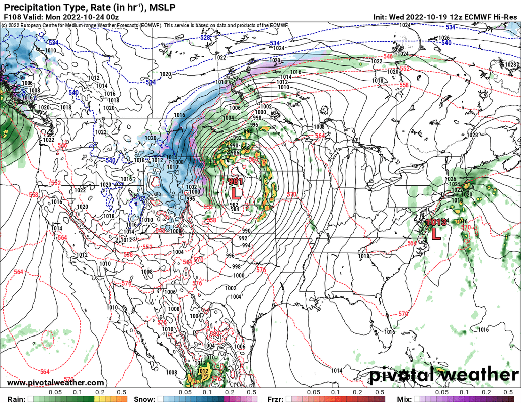
Below is a screenshot from the 12z ECMWF. It shows potential severe/tornadic storms from our area all the way up into eastern SD/western MN during the late afternoon/early evening hours on Sunday. Especially since dewpoints are depicted to be in the 60s in eastern NE and western IA. If things come together like this, it will likely be a very active day across a pretty large portion of the Country (still too far out to know for sure though):
-
damonhynes

- Parks & Recreation
- Posts: 1282
- Joined: Wed Aug 27, 2014 12:35 am
- Location: Montgomery County, Texas
Re: 2022 Weather Thread
And yours truly will be in TX/OK on Sunday, naturally. It's a fool's errand to chase those 50-60MPH storms anyhow :-)stormchaser wrote: Wed Oct 19, 2022 6:26 pm In case anyone is wondering, this is the reason for the severe weather/tornado potential in the area. A VERY large/strong storm system is expected to move out into the plains this weekend.
Below is a screenshot from the 12z ECMWF. It shows potential severe/tornadic storms from our area all the way up into eastern SD/western MN during the late afternoon/early evening hours on Sunday. Especially since dewpoints are depicted to be in the 60s in eastern NE and western IA. If things come together like this, it will likely be a very active day across a pretty large portion of the Country (still too far out to know for sure though):
-
stormchaser
- Planning Board
- Posts: 2380
- Joined: Fri Jun 01, 2018 1:14 pm
Re: 2022 Weather Thread
Yeah, that part always sucks. Basically you just pick your spot and cross your fingers because it's nearly impossible to keep up with the storms...damonhynes wrote: Wed Oct 19, 2022 8:55 pm And yours truly will be in TX/OK on Sunday, naturally. It's a fool's errand to chase those 50-60MPH storms anyhow :-)
-
stormchaser
- Planning Board
- Posts: 2380
- Joined: Fri Jun 01, 2018 1:14 pm
Re: 2022 Weather Thread
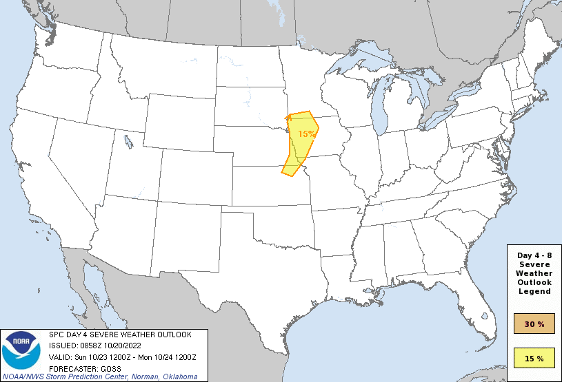
As expected, the SPC has added a risk area for our area for Sunday with a "day 4" that includes Omaha.
Still some questions remain. One of the biggest of which is the amount of "moisture return". Surface dewpoints are expected to be in the upper 50s to around 60 (which should be sufficient for most areas). However, aloft the dewpoints decrease fairly quickly (very common for these late season setups). This lack of "moisture depth" may inhibit surface based convection which would limit tornado potential (and possibly the overall severe potential as well). In addition, the forcing mechanism is a cold front which tend to favor more outflow dominant/wind producing storms.
Long story short, the primary severe weather threat will likely be a damaging wind event. However, with backed southeasterly surface winds (especially east/northeast of the low), a tornado threat seems plausible in this area IF moisture depth is sufficient. This tornado threat currently looks most likely in parts of northwest IA where surface winds are currently depicted more favorable - again, IF moisture depth is sufficient. That said, a tornado threat certainly exists in our are too though surface winds aren't quite as favorable here. If any discrete supercells can form out ahead of the cold front, those would likely have the highest potential in our area.
All of this is based on the current depicted model data (which can change quickly). Timing of this system is going to be pretty key if Omaha itself is at risk or not. If the system speeds up, the threat will probably end up east of here (and be less of a threat due to less of a chance for moisture return to occur). If it slows down, moisture return will be better and consequently the severe weather threat will be more robust (and the Omaha area will likely be impacted).
Either way, should be a pretty interesting late season severe weather day.
Here is the current outlook from the SPC for Sunday:
Still some questions remain. One of the biggest of which is the amount of "moisture return". Surface dewpoints are expected to be in the upper 50s to around 60 (which should be sufficient for most areas). However, aloft the dewpoints decrease fairly quickly (very common for these late season setups). This lack of "moisture depth" may inhibit surface based convection which would limit tornado potential (and possibly the overall severe potential as well). In addition, the forcing mechanism is a cold front which tend to favor more outflow dominant/wind producing storms.
Long story short, the primary severe weather threat will likely be a damaging wind event. However, with backed southeasterly surface winds (especially east/northeast of the low), a tornado threat seems plausible in this area IF moisture depth is sufficient. This tornado threat currently looks most likely in parts of northwest IA where surface winds are currently depicted more favorable - again, IF moisture depth is sufficient. That said, a tornado threat certainly exists in our are too though surface winds aren't quite as favorable here. If any discrete supercells can form out ahead of the cold front, those would likely have the highest potential in our area.
All of this is based on the current depicted model data (which can change quickly). Timing of this system is going to be pretty key if Omaha itself is at risk or not. If the system speeds up, the threat will probably end up east of here (and be less of a threat due to less of a chance for moisture return to occur). If it slows down, moisture return will be better and consequently the severe weather threat will be more robust (and the Omaha area will likely be impacted).
Either way, should be a pretty interesting late season severe weather day.
Here is the current outlook from the SPC for Sunday:
-
stormchaser
- Planning Board
- Posts: 2380
- Joined: Fri Jun 01, 2018 1:14 pm
Re: 2022 Weather Thread
Here is the simulated radar from the 00z ECMWF. This model has been much more consistent than the GFS so for the time being, it's the one I'm favoring with this set up.
As I explained above, moisture return is one of the biggest question marks with this set up (as is timing/storm mode). However, the ECMWF has been trending more favorably toward moisture return being less of an issue and depicts what would likely be a larger number of potentially discrete supercells (and consequently a higher tornado threat) near the Missouri River Valley (including Omaha - with development occurring during the late afternoon hours). Still the primary threat looks to be in northwest IA BUT if things trend slower, we could end up in the bullseye.
I'm not sold on a widespread tornado threat yet (as I've explained above) but just putting it out there that this still has the potential of being a pretty dangerous tornado day too and needs to be watched closely. It's just too early to know but I also want people to be aware of the potential. Once medium range guidance starts picking up on things, some of these questions should hopefully become clearer.
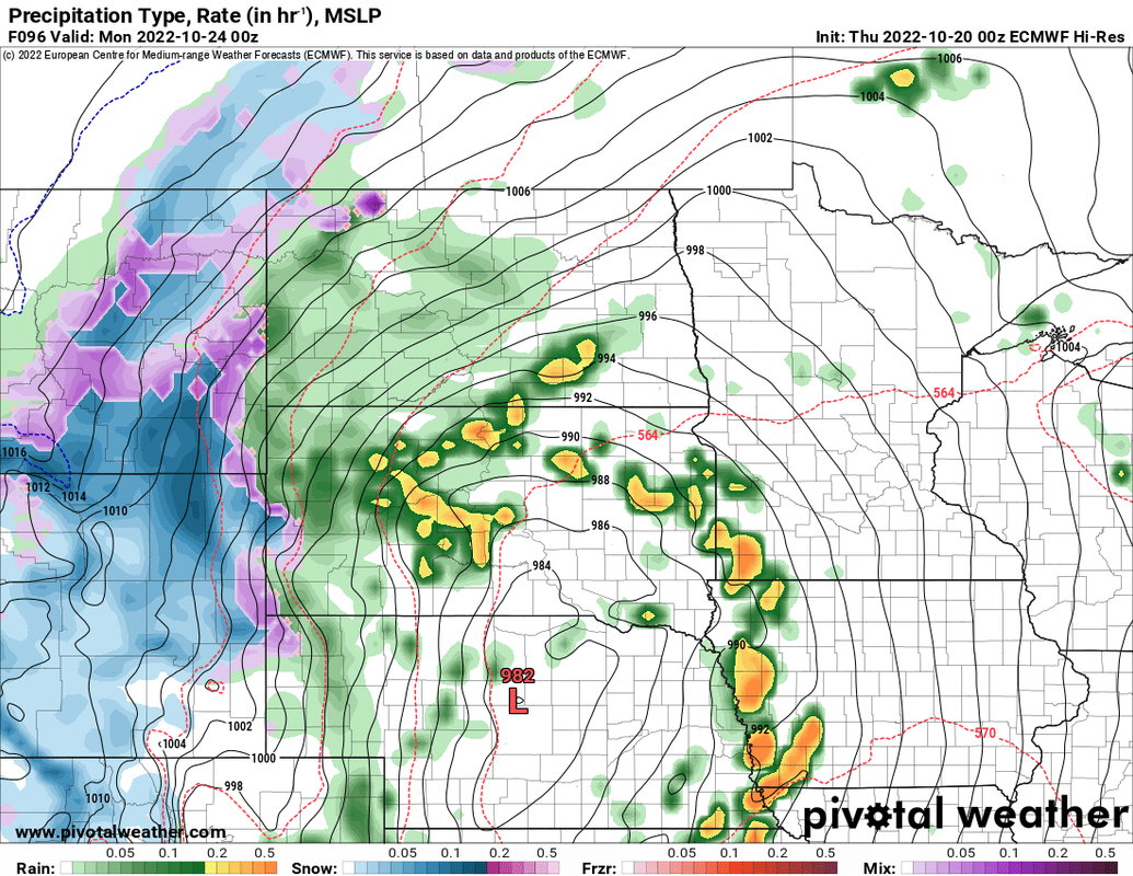
As I explained above, moisture return is one of the biggest question marks with this set up (as is timing/storm mode). However, the ECMWF has been trending more favorably toward moisture return being less of an issue and depicts what would likely be a larger number of potentially discrete supercells (and consequently a higher tornado threat) near the Missouri River Valley (including Omaha - with development occurring during the late afternoon hours). Still the primary threat looks to be in northwest IA BUT if things trend slower, we could end up in the bullseye.
I'm not sold on a widespread tornado threat yet (as I've explained above) but just putting it out there that this still has the potential of being a pretty dangerous tornado day too and needs to be watched closely. It's just too early to know but I also want people to be aware of the potential. Once medium range guidance starts picking up on things, some of these questions should hopefully become clearer.
-
Busguy2010
- City Council
- Posts: 7411
- Joined: Sun Apr 10, 2011 12:32 am
- Location: North Central Omaha
Re: 2022 Weather Thread
Now that I'm back in Omaha, I'm catching up on things. Garden is toast now, so I checked what the real low was that other day (I think it was Tuesday morning) and that low of 16 was actually the record low for that date.
-
GetUrban
- Planning Board
- Posts: 2650
- Joined: Sun Nov 23, 2008 9:07 pm
- Location: Omaha
Re: 2022 Weather Thread
It’s amazing how quickly the trees that still had leaves dropped them after that hard freeze. Those that held on to their leaves are all brown now.Busguy2010 wrote: Thu Oct 20, 2022 5:18 pm Now that I'm back in Omaha, I'm catching up on things. Garden is toast now, so I checked what the real low was that other day (I think it was Tuesday morning) and that low of 16 was actually the record low for that date.
He said "They are some big, ugly red brick buildings"
...and then they were gone.
...and then they were gone.
-
skinzfan23
- City Council
- Posts: 11688
- Joined: Mon Feb 09, 2004 5:26 pm
- Location: Omaha/Bellevue
Re: 2022 Weather Thread
Yeah, had a good few weeks, but unlike last year which color seemed to last a little longer, the frost hurt that. Although, I still have quite a few nice reds in our neighborhood.