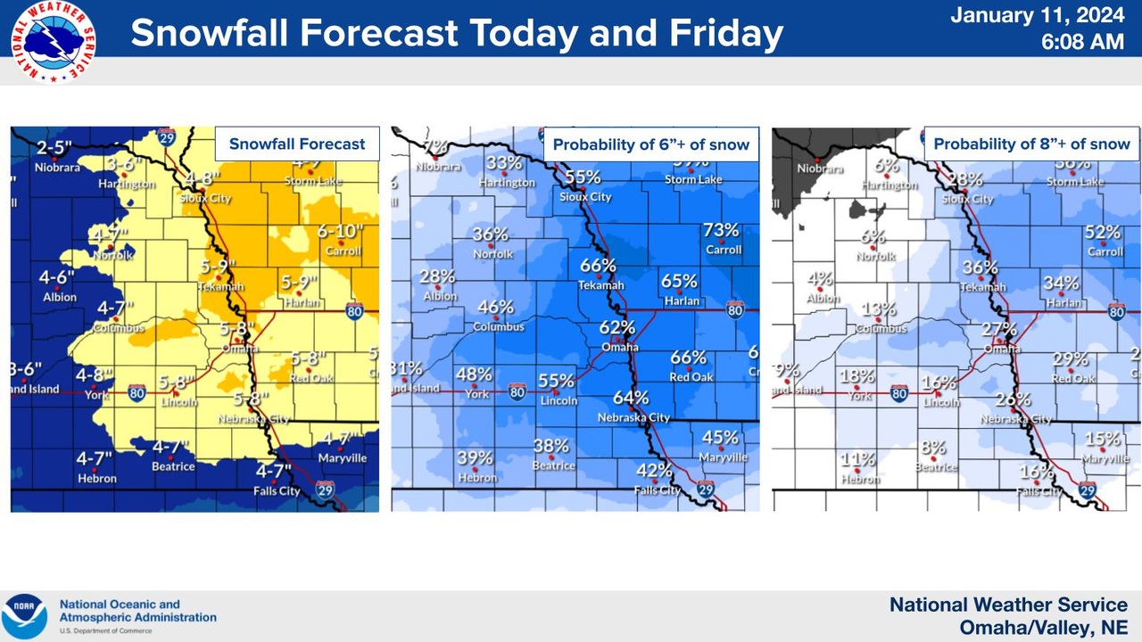
Winter storm warning has been expanded further west and east to include all of eastern NE and entire state of IA.
Probably somewhere in the 6"-10" range for snow totals in Omaha with this storm (IMO) with at least near blizzard conditions fairly likely tonight and the first half of tomorrow. Wouldn't be surprised to see a blizzard warning issued if they think the winds will be strong enough for long enough period of time. Either way, tonight and the first part of tomorrow are going to be particularly rough.
skinzfan23 wrote: Thu Jan 11, 2024 10:03 am
I saw wowt moved the start time back to closer to late evening (8-9pm) is that the case or do you think it will still start earlier?
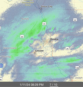
The latest run of the HRRR shows it starting between 02Z or 03Z which would be 8pm or 9pm.
skinzfan23 wrote: Thu Jan 11, 2024 10:03 am
I saw wowt moved the start time back to closer to late evening (8-9pm) is that the case or do you think it will still start earlier?
Even if models get the features of a storm generally accurate one of the things they struggle with is timing. Every major model is running one of it's every 6 hour runs right now so we'll see what it says, but yeah compared to yesterday, the timing of this looks to be slightly delayed.
Blizzard Warning in effect for Central Iowa starting tomorrow morning. We do not have one issued at least not yet. I believe they had a Blizzard last year at Christmas, I drove in it.
Cermak wrote: Thu Jan 11, 2024 5:32 pm
Blizzard Warning in effect for Central Iowa starting tomorrow morning. We do not have one issued at least not yet. I believe they had a Blizzard last year at Christmas, I drove in it.
We may or may not be upgraded. Winds in IA will be stronger as the low deepens off to our east
Louie wrote: Thu Jan 11, 2024 8:40 pm
This has been a dud so far.
It got moved from starting a 5 to starting at 8,9,10. We definitely are in a void right now. We all know what it's called.
The stuff coming up from the south looks like it's filling in better, so it shouldn't be much longer.
Difficult to measure at this point but I would estimate about 5-6 inches of snow so far at my house in Millard with light/moderate snow falling. Considering it will snow for a while yet, it wouldn't surprise me to see final snow totals of 8-9 inches. The wind will also get stronger this morning so blowing snow will become a larger issue (even though it's already a mess).
stormchaser wrote: Fri Jan 12, 2024 7:08 am
Difficult to measure at this point but I would estimate about 5-6 inches of snow so far at my house in Millard with light/moderate snow falling. Considering it will snow for a while yet, it wouldn't surprise me to see final snow totals of 8-9 inches. The wind will also get stronger this morning so blowing snow will become a larger issue (even though it's already a mess).
Really escalated overnight. I don't envy anyone who has to be on the roads today.
Louie wrote: Fri Jan 12, 2024 8:49 am
Really escalated overnight. I don't envy anyone who has to be on the roads today.
Yep, so far it's played out pretty much as I was expecting. Wedge of dry air at the beginning held off snow for the first few hours but once it got going, it accumulated quickly.
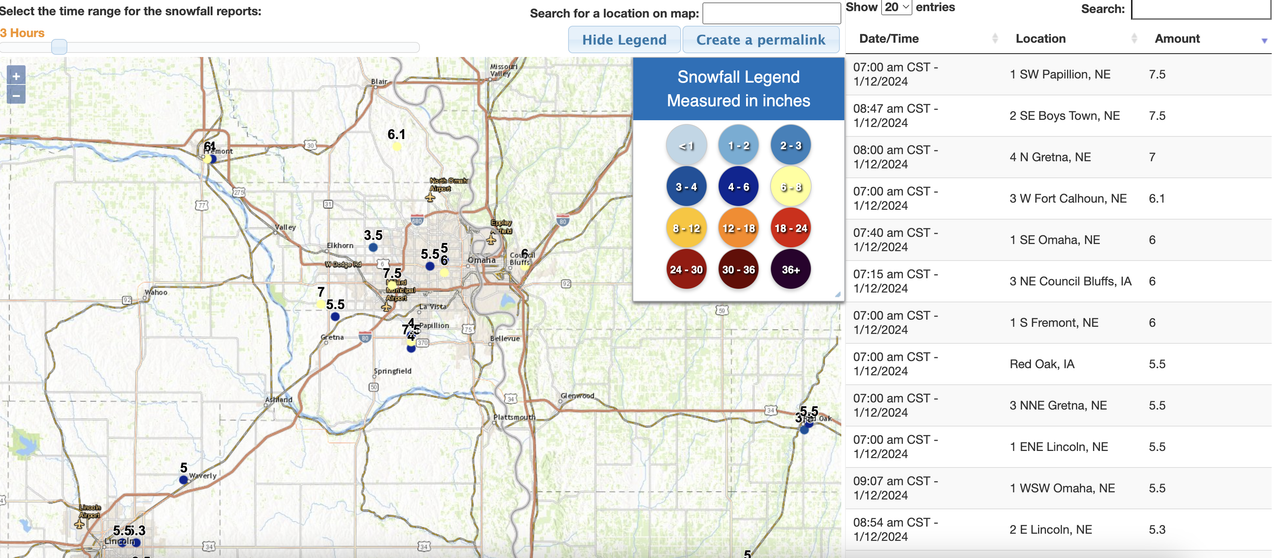
Several reports across the metro of over 6 inches of snow and some over 7 inches so far with probably at least a couple inches yet (depending on if dry air kills off the precip - otherwise there is plenty off to our west that needs to come through yet). The HRRR shows us getting another 3"-6" of snow. Given that dry air is starting to work into the area, I'm assuming it'll only be an inch or 2 but I guess we will see.
Just looking out the window, this is a pretty nasty snowstorm, probably the worst I’ve seen in a while, probably years. I would think we are close to Blizzard conditions. Currently Moderate and blowing snow, winds at 23 mph, temp around 6. At 11:50 am SW Omaha.
Last edited by Cermak on Fri Jan 12, 2024 12:41 pm, edited 1 time in total.
Pretty impossible to get a good measure. 5.5 or 6" in my bucket, but easily 18" drifts next to just a dusting. I gotta believe a good amount didn't make it in the bucket and some got swept out of it, so i can buy my bucket measure being a bit slim. But I agree it's overall a pretty brutal storm.
Just shoveled driveway since it's going to be punishingly cold over the next few days - with the piles on the sides already from snow earlier this week, we had 2 foot drifts in some places. Hard to say exactly, but sure seems like more on the 8 side than the 4 side. Middle of the street had over 8in.
Almost nobody out, side street I live on is totally unplowed, the neighbor with the truck made it through just fine, some dude in a WRX zipped through at about 30 and I think made it.
I hope most folks could work from home or not go in today!
I live very near 680 in SW Omaha, I was just outside and was thinking it looked like at least 8 inches and probably 9-10. The snow is very light and powdery. I had a drift right at my front door which looked to be about 2 feet, I don’t ever recall seeing a drift at my front door that big before. Pretty impressive storm. We’ve had two wimpy winters in a row maybe that’s why this seems extra bad to me.
I live very near 680 in SW Omaha, I was just outside and was thinking it looked like at least 8 inches and probably 9-10. The snow is very light and powdery. I had a drift right at my front door which looked to be about 2 feet, I don’t ever recall seeing a drift at my front door that big before. Pretty impressive storm. We’ve had two wimpy winters in a row maybe that’s why this seems extra bad to me.
Nice - I live in that area also (between 132nd and 120th south of Center) - and I agree, definitely at least 8 or 9 at my house (possibly slightly more).
Minus 16 this morning in Omaha and we had -24 just 3 years ago February 2021. Don’t recall having two cold snaps this strong within a 3 year period in Omaha before. At least not since I’ve lived here since 1985. And another chance of at least -20 tomorrow morning.
Last edited by Cermak on Mon Jan 15, 2024 7:36 am, edited 1 time in total.
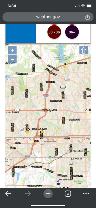
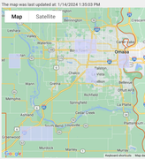
Power outage occurred in midtown a few ours ago and I was affected, issue has been resolved by OPPD.
However the outage map shows new flagged areas of west omaha, Papillion and downtown who are experiencing outages. Each purple square encompasses between 1-100 reports by residents.
The cold air is expected to stick around for several days yet with a brief warm up into the low 20s on Wednesday before things get cold again. Also, a clipper system is expected to bring some snowfall to the area toward the end of this upcoming week (with some accumulations possible though probably something in the 1"-3" or 2"-4" inch snowfall range).
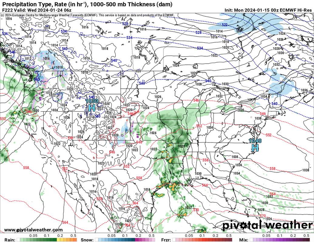
Then finally things start to warm up in the latter half of the weekend and into the following week where believe it or not, it might be warm enough for rain (barely - temps in the mid-30s). This "could" lead to some flooding issues if it ends up being heavy enough rain - too far out to really know.
Simulated radar from the 00z ECMWF for Tuesday/Wednesday (January 23/24):
Most short and medium range models I've seen have shifted the track of the snow further north putting Omaha itself on the southern edge of most of the snow for on Thursday (especially afternoon/evening).
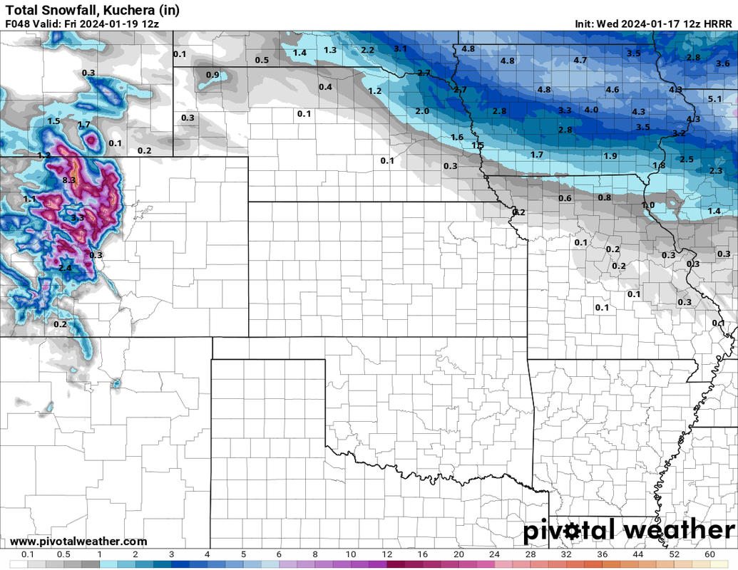
Probably a swath of 2"-5" of snow that will hopefully pass to our north and Omaha itself will only see relatively minor accumulations tomorrow (maybe an inch or 2 in Omaha itself). Unfortunately maybe enough to cover up the ice all over the place which is going to cause issues with people not being able to see it and probably driving too fast (like normal for some).
12z HRRR depicted snow totals:
Last edited by stormchaser on Wed Jan 17, 2024 1:04 pm, edited 1 time in total.
Cermak wrote: Wed Jan 17, 2024 12:49 pm
After Sunday and into next week the weather looks pretty good. Definitely warmer. Should melt some snow.
Yep, once we get past the next few days late this weekend into next week looks better.
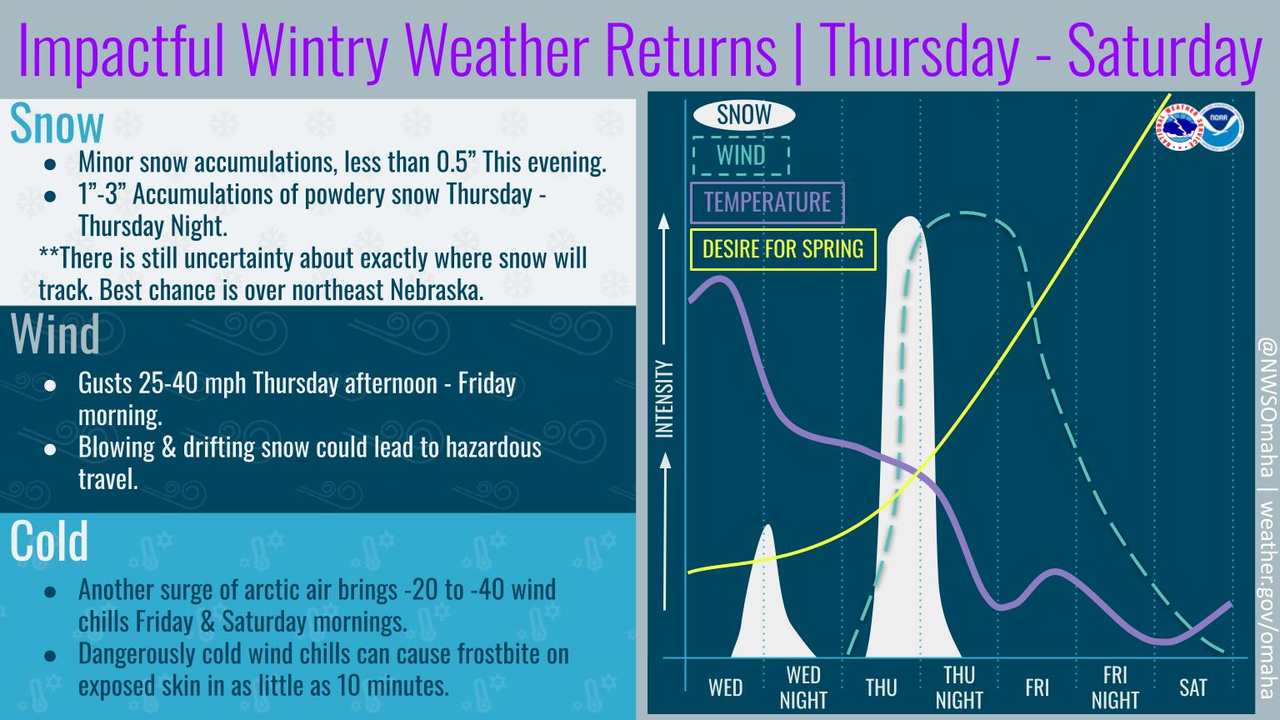
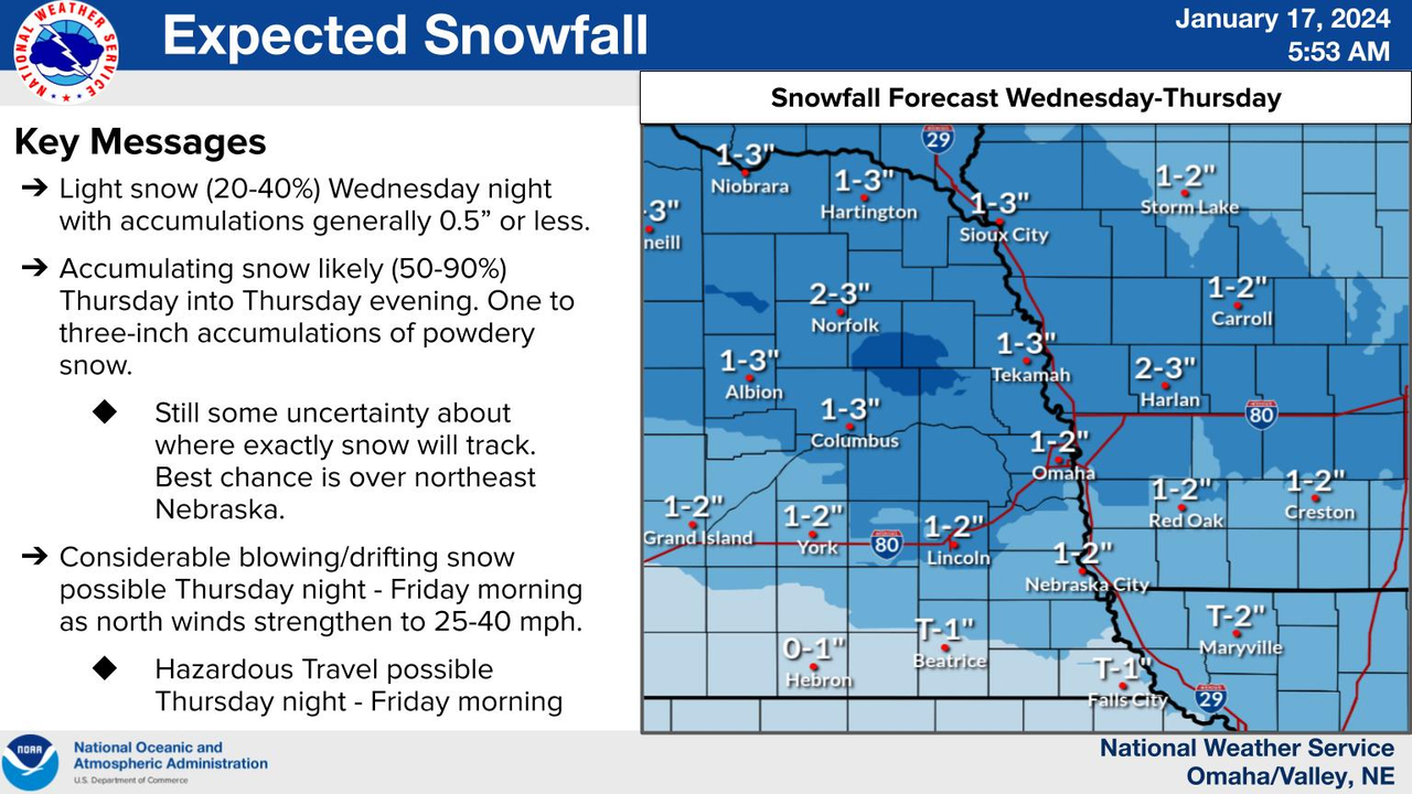
Winter weather advisory has been issued for much of eastern NE/western IA including Omaha. Most places will see relatively minor snow accumulations (just an inch or 2) but the main issue will be the wind causing blowing snow issues Thursday afternoon into Friday - and of course the cold (again).
Impacts:
NWS snow forecast (personally I think the main band of snow will end up north further with Omaha more on the edge):
The evening commute tonight is probably going to be a rough one in the Omaha area.
While we are only expecting 1-3 inches of snow (with a few places seeing slightly more than that - probably to our north), the wind will cause blowing and drifting snow. Wind gusts of ~40mph will reduce visibility to .5 miles or less at times and there could end up being road closures - especially out in rural areas north of Omaha.