Mesoscale Discussion 0574
NWS Storm Prediction Center Norman OK
0105 PM CDT Tue Apr 30 2024
Areas affected...portions of eastern Nebraska far northeastern
Kansas...western Iowa and northwest Missouri
Concerning...Severe potential...Watch likely
Valid 301805Z - 301930Z
Probability of Watch Issuance...80 percent
SUMMARY...Isolated storm development is possible by 19-20z across
parts of eastern NE and far northeast KS. Initially supercells may
support a risk for all hazards.
DISCUSSION...As of 1800 UTC, visible imagery showed deepening
cumulus towers east of a weak surface cyclone across portions of
eastern NE and northern KS. Signs of subtle forcing for ascent are
beginning to overspread this regional ahead of a low-amplitude
shortwave trough over western NE. Amidst increasing ascent and
strong diurnal heating, remaining MLCINH is rapidly eroding.
Observational trends and Hi-res model guidance indicate isolated
storm development is possible as early as 19-20z across parts of
eastern NE and far northern KS. Upper 50s to low 60s F surface
dewpoints and steep mid-level lapse rates are supporting MLCAPE of
1500-2000 J/kg. Given the potential for strong updrafts,
organization into initial supercells is expected with 40-50 kt of
effective shear observed on area VADs. Isolated storms will be
capable of large to very large hail and damaging wind gusts
initially. Tornadoes will also be possible, especially near the warm
front farther east and south, where lower cloud bases and stronger
low-level shear are favored.
While the initial storm mode is expected to be primarily
supercellular, the surface cold front will impinge on the western
warm sector later this afternoon. The increase in linear forcing and
additional storm development through the afternoon suggests storm
interactions may favor upscale growth into short line segments and
clusters with time. While, there is some uncertainty on storm mode,
a tornado watch is likely this afternoon.
Ehh, as expected - it’s just tough to get tornadoes with a setup like this (which is a good thing obviously for most) as storms tend to get undercut and are more outflow dominant…
It's been delightfully moist the last couple weeks. Starting on the 16th, we've almost gotten our full months worth of rain in that period of time. It looks like tomorrow night through Thursday night might be another washout, and we stand a chance of finishing the month with a surplus.
Busguy2010 wrote: Tue Apr 30, 2024 9:14 pmIt looks like tomorrow night through Thursday night might be another washout, and we stand a chance of finishing the month with a surplus.
I don't think there's any chance for more rain in April after today.
Busguy2010 wrote: Tue Apr 30, 2024 9:14 pmIt looks like tomorrow night through Thursday night might be another washout, and we stand a chance of finishing the month with a surplus.
I don't think there's any chance for more rain in April after today.
Lolz, I got my dates wrong. Oh well.
Regardless, I don't think anybody is complaining about dry weather lately. I know I'm one of the biggest offenders when it comes to getting upset about no rain, and even I have been waiting for it to dry out so I can get some dirt turned.
And again we have another good washout on tap tomorrow.
Maybe a few stronger storms in the area late tonight - mostly for damaging wind/hail but the risk is low here (more of a risk to our southwest and especially into KS.
Monday, May 6th looks like it "could" be another dangerous day in parts of the area with another setup that looks favorable for tornadoes. This time it's depicted to be further west but it's close to our area too.
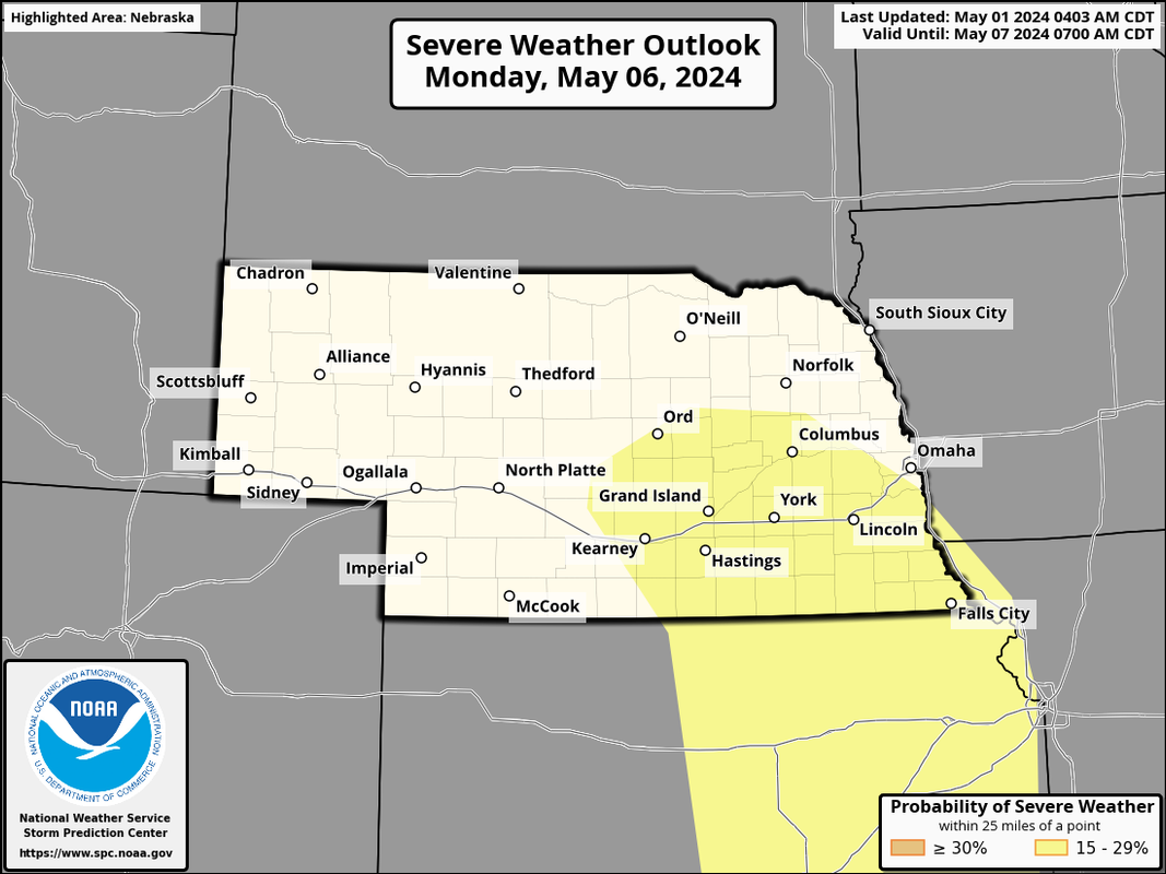
The SPC has a day 6 outlook showing the area they think is most at risk currently. Based on the models I've seen, I wouldn't be surprised if this area is expanded to the north west some. I'm sure the exact locations will change either way as we get closer though obviously and could easily be shifted east too depending on track/timing of the system.
Regardless, our active pattern looks to continue...
This coming Monday continues to look like a potentially dangerous day including a risk for large hail, damaging wind, and tornadoes across much of eastern NE.
Unfortunately this does currently look like the type of set up that could produce another tornado outbreak somewhere in the region. It's obviously way too early to know but the model trends are pretty concerning currently - especially for areas west/southwest of Omaha towards Hastings and Grand Island (though Omaha would be included in that risk as well).
Plenty of time for things to change though.
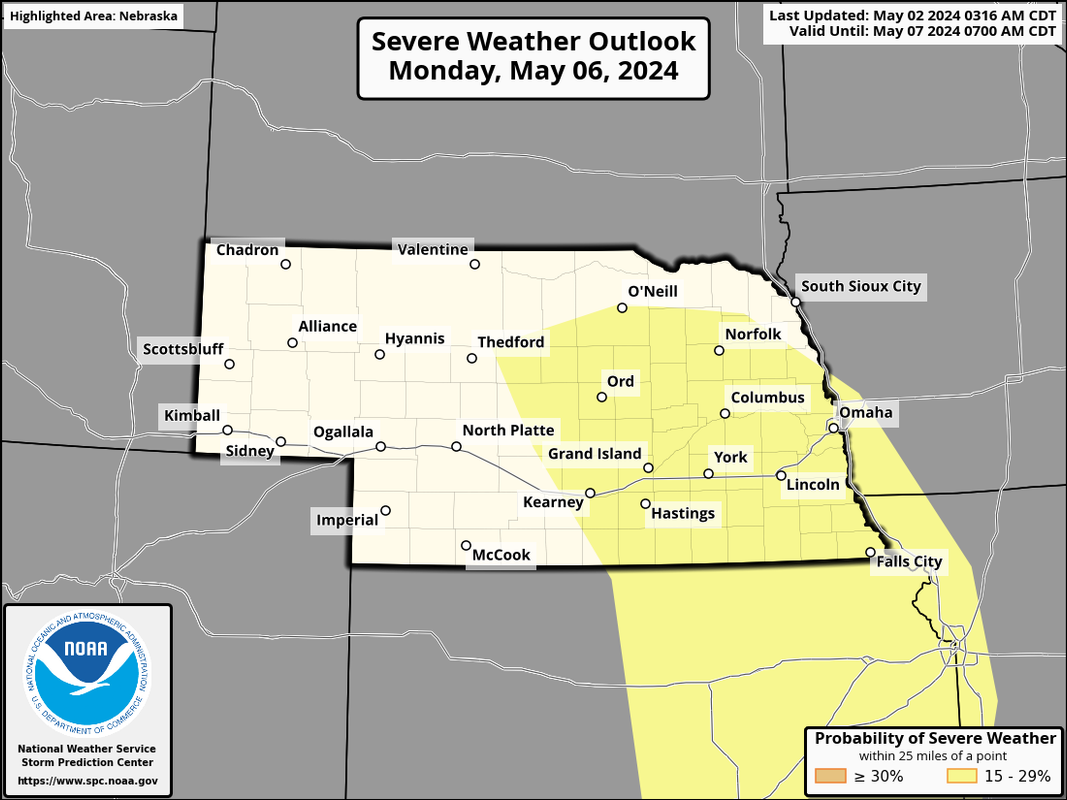
Here is the "day 5" outlook for Monday that now includes Omaha (so they expanded west and east some with the risk).
Most places along and east of I-680 had between 1" and 1.25" of rain last night. Areas of western Omaha (mostly west of 144th street) not as much - most places out there between .4" and 1" based on radar estimates anyway with the lowest amounts in northwest Omaha (like Elkhorn/Bennington)...
I'd believe it if I got over an inch. It never really completely stopped raining after 8 or so, and every time it slowed down for a bit, it came down super heavy. Then around 3 it was just a complete washout for what seemed like at least a good hour. The rain we've been getting lately has been wonderful! It looks like there's even a couple more chances for a ton more this weekend and to start next week!
thenewguy wrote: Thu May 02, 2024 1:03 pm
out at my mom's place (near malvern), they had 2.5" hail yesterday. They didn't have any broken windows, but said the siding took a beating
that had to be ugly. How did the trees take it with that size. Bet a roof is in the works too along with the siding.
For the record NEBUGEATER does not equal BUGEATER !!!!!!!
thenewguy wrote: Thu May 02, 2024 1:03 pm
out at my mom's place (near malvern), they had 2.5" hail yesterday. They didn't have any broken windows, but said the siding took a beating
that had to be ugly. How did the trees take it with that size. Bet a roof is in the works too along with the siding.
I think the trees did as ok as possible- a lot of them are pine around her place but some of the neighbors really took a beating. They hadn't made it up on the roof to look at it yet because of all the rain (and they are getting old) but i suspect it's going to be a hefty chunk.
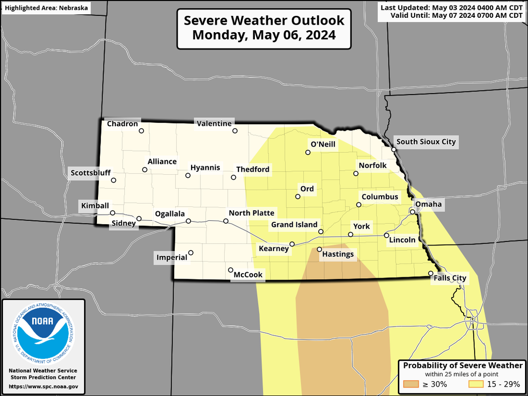
The SPC has increased the risk for Monday for parts of the area. It continues to look like a tornado outbreak will once again be possible - especially in areas west/southwest of Lincoln (in the Grand Island/Hastings area - at least that's the primary risk area). However, there will be a risk here too - it's just too far out to know if these storms will remain supercellular as the move our direction or grow more upscale into a line and become more of a damaging wind event.
I wouldn't be surprised if the SPC further upgrades the risk in the coming days - I'd guess to a "moderate risk" and 15% tornado risk area for west/southwest of Lincoln towards Hastings, etc but I'm just speculating right now and plenty can change yet.
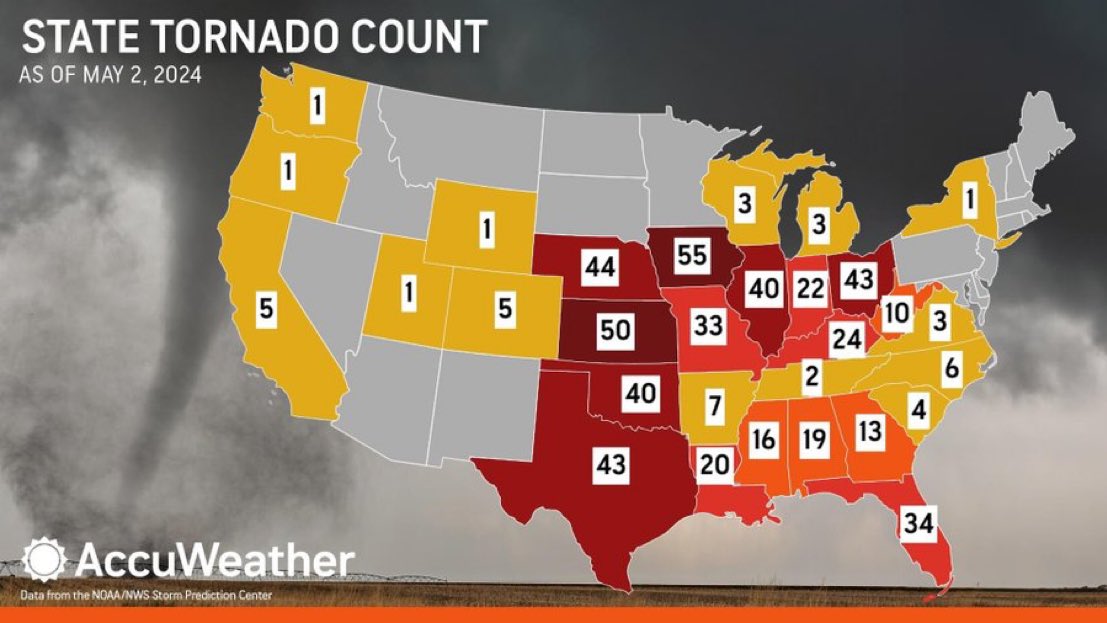
What a crazy year so far already and we are not even close to being done and this number is likely to climb (maybe drastically) on Monday. Of course the majority here and in IA happened with one single tornado event, but still.
For comparison, Nebraska sees 45 tornadoes on average for the entire year.
so for a while, they were talkin about Dixie Alley being the new tornado alley. But it seems like these things run in cycles, and now Tornado Alley is really kickin it up a notch. Is that an accurate assumption? I assume El Nino/La Nina impact where tornados form pretty substantially on a yearly basis?
thenewguy wrote: Fri May 03, 2024 7:55 am
so for a while, they were talkin about Dixie Alley being the new tornado alley. But it seems like these things run in cycles, and now Tornado Alley is really kickin it up a notch. Is that an accurate assumption? I assume El Nino/La Nina impact where tornados form pretty substantially on a yearly basis?
Yeah, they definitely run in cycles and for a while, dixie alley did see more frequent (and stronger) tornadoes but that's obviously changed this year anyway.
I still believe that when we are transitioning from El Nino to La Nina (or vice versa) during Spring, that's when the bigger tornado outbreaks tend to occur. Impossible to prove though of course because there are TONS of other variables too.
Just to reinforce my concern for Monday - it's not a good sign when the SPC is warning of potential strong tornadoes on a day 4 outlook. Can't say I remember ever seeing that before tbh.
From the day 4 outlook:
"Thunderstorms will likely erupt along the length of the dryline by late Monday afternoon from southern NE into central KS and north-central OK. Supercells are likely to be the dominant mode initially given the strength of the deep-layer shear. Both very large hail and tornadoes will be possible with these supercells as they spread eastward across the southern/central Plains through Monday evening. With a southerly low-level jet forecast to strengthen to at least 50-60 kt Saturday evening, a corresponding rapid increase in low-level shear will likely support a continued threat for tornadoes with any discrete convection. Some of these tornadoes could be strong. The severe threat will likely continue Monday night with eastward extent across the Plains, before convection possibly weakens some towards early Tuesday morning. Given increased confidence in high-end severe potential, a 30% severe area has been introduced from parts of southern NE into central KS and north-central OK."
Still looking like a potential tornado outbreak tomorrow in parts of the area - especially areas south/southwest of Omaha.
Due to time constraints, I’ll likely be targeting somewhere along the KS/NE border (maybe Hebron, NE - maybe adjacent parts of northern KS) based on the 12z HRRR anyway.
In Omaha itself, some tornado/severe weather threat exists but this is trending towards growing into an HP event in the local area which if that happens will mean the severe threat will gradually decrease and transition more to a heavy rain event. Still some threat though so don’t let down your guard.
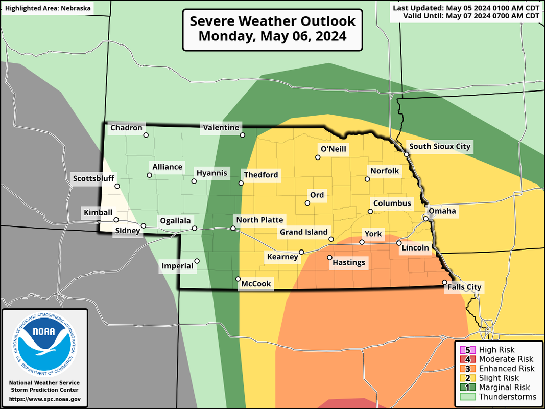
Latest SPC outlook including an enhanced risk to our south and moderate risk in parts of KS/OK:
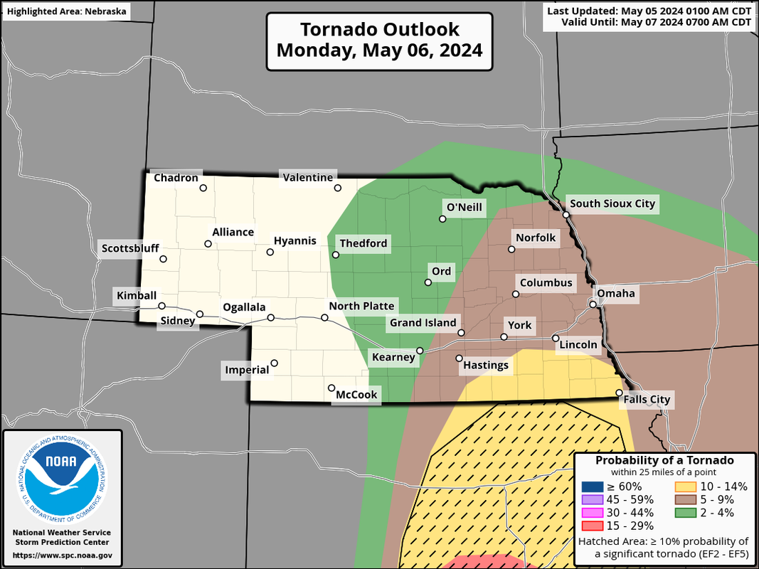
Areas to the south of Omaha are in a 10% tornado risk area as well:
stormchaser wrote: Fri May 03, 2024 7:38 am
What a crazy year so far already and we are not even close to being done and this number is likely to climb (maybe drastically) on Monday. Of course the majority here and in IA happened with one single tornado event, but still.
For comparison, Nebraska sees 45 tornadoes on average for the entire year.
I’m a bit surprised, with the crazy spring we’ve had so far, Minnesota, North Dakota and especially South Dakota haven’t got into the act..
Omaha Cowboy wrote: Sun May 05, 2024 1:38 pm
I’m a bit surprised, with the crazy spring we’ve had so far, Minnesota, North Dakota and especially South Dakota haven’t got into the act..
I’m sure it’s coming though.. Unfortunately..
Thanks for this info …
Ciao..LiO…Peace
Yeah, I’m sure it’s just a matter of time.
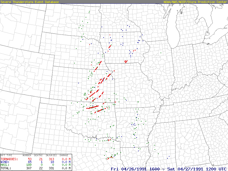
The #1 analog (or similar setup) for tomorrow is 4-26-91. Several tornadoes occurred this day south and then east of Lincoln including an F3 (before the “enhanced scale”) - in Gage to Otoe county.
Of course this doesn’t mean the same will happen tomorrow but don’t be surprised if there are tornadoes tomorrow in a similar area anyway (albeit, probably further west) in addition to damaging wind/hail.
Still looking like more of a damaging wind/hail threat today in the Omaha area than a tornado threat though I still believe there will probably be a few tornadoes near the KS/NE border - in general, things are looking pretty linear in our area anyway.
Storms should fire around Noon out near the Kearney area and probably go severe fairly quick. These storms may at times take on a supercellular structure before growing upscale into a line. This line will probably have some embedded supercells as it pushes east across NE so there will be at least some tornado threat - but the main threat should be damaging wind/hail.
stormchaser wrote: Mon May 06, 2024 11:43 am
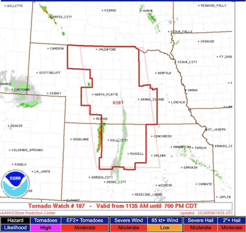
Tornado watch has been issued for areas of central NE/KS until 7 PM. Just the beginning of what will happen today though...
One of the largest single tornado watches I can remember.
stormchaser wrote: Mon May 06, 2024 11:43 am
Tornado watch has been issued for areas of central NE/KS until 7 PM. Just the beginning of what will happen today though...
One of the largest single tornado watches I can remember.
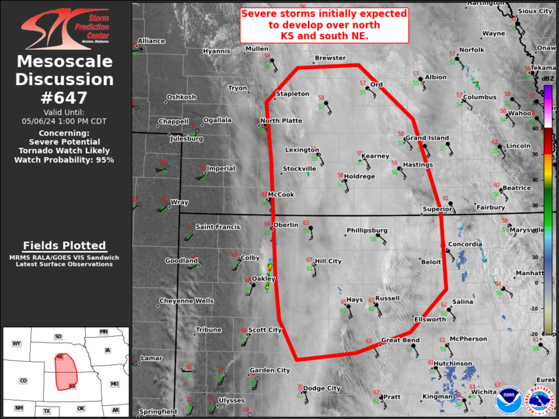
Yep, it's giant. I found it interesting they went with a "high" risk for tornadoes and a moderate risk for EF2+ tornadoes. These initial storms will probably be supercellular but the low level jet will get even stronger throughout the day. If the storms today stay discrete, it would be pretty dangerous in some areas. Chances are they'll go more linear of be line segments anyway but something to keep an eye on...
Tornado watch up until 11 for Lincoln and Omaha including a risk for a few strong tornadoes (though IMO) that risk is further south from the NE/KS border on south.









 …
…