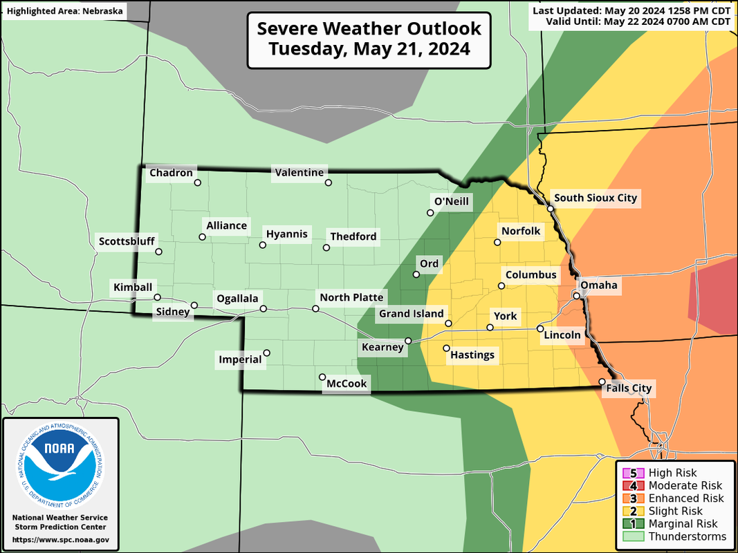
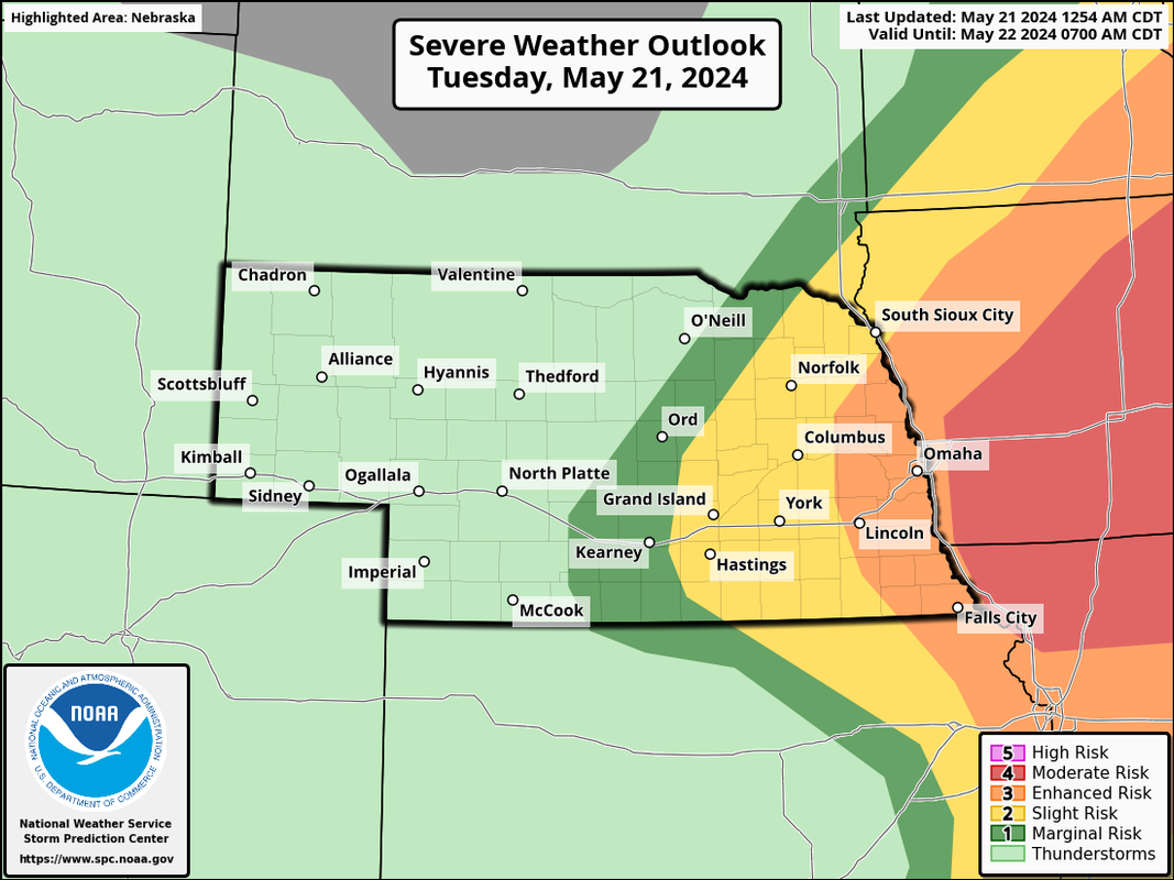
The Omaha area has been upgraded to an "enhanced risk" (barely - but still) for tomorrow with a "moderate risk" off to our east into Iowa. I'm not surprised to see some shift west in the outlook based on what short range models have been showing.
Damaging wind, large/very large hail, and tornadoes will be possible - including a risk for a few strong tornadoes.
I went west on HWY 36 about an hour ago and it looked pretty hairy. I wasn't necessarily storm chasing perse, but once I got home, I see there's a tornado warning just north of Crescent right now, and the way the storm tracked, I would have been right where a potential genesis would have been occurring.
Little Papio and Cole creek looked and sounded like raging rivers.
I swear when I was out west of Bennington, between flashes, I thought I saw a rope between flashes of lightning. That warning just north of Cresent, and now a later one around Harlan confirms to me I was in the vicinity of a tornado, or at least the mesocyclone that might have produced one. I didn't even know it, I just wanted to see some lightning lol.
Unfortunately a tornado outbreak is likely today with a threat for strong tornadoes. A moderate risk has been issued in IA (just barely east of Omaha) but Omaha is at risk of seeing strong tornadoes too - especially in the early afternoon.
Please be weather aware - this is probably going to be a very dangerous day.
I’ll have to check my rain gauge as soon as I can this morning, I’m guessing at least 3 inches overnight. It’s been a while since we’ve seen this much rain, should be making a huge dent in the drought.
**Important**
Please don't let down your guard. I know many people are thinking this morning's storms probably took care of the threat for this afternoon. Unfortunately it 100% did not and what has happened so far this morning is pretty much exactly what was expected to happen and what short range forecast models have been showing on a consistent basis.
Long story shorty, there will be plenty of time for the atmosphere to recover and reload here over the next few hours.
Models have been consistently showing a potentially tornadic supercell developing and moving into or very close to Omaha around noon today (give or take an hour or so). This supercell would have strong tornado potential. The risk is higher off to our east into Iowa BUT considering how consistent models have been with developing this supercell in or very close to Omaha and considering this storm would basically be right where the low pressure is, Omaha is probably in a pretty dangerous spot.
Does that mean Omaha specifically will be hit? Obviously that's impossible to know - but somewhere close by is at serious risk for tornadoes (and large hail, etc).
Not trying to hype or scare anyone, but what is about to happen in a few hours isn't going to be something to mess around with - especially as you head into parts of Iowa.
Cermak wrote: Tue May 21, 2024 6:14 am
I’ll have to check my rain gauge as soon as I can this morning, I’m guessing at least 3 inches overnight. It’s been a while since we’ve seen this much rain, should be making a huge dent in the drought.
I can't believe the amount of rain today. Last night around 11-midnight was just bad enough, let alone to have ANOTHER storm just as bad, If not worse as far as rainfall rate. Little papio creek is basically up to the trail and running 30+ mph, Cole Creek is over the street at 72nd by a couple feet. To put that into perspective, it's probably a good 12 feet (?) deeper than normal. It might be worse than 1999. I really wonder how full Cunningham is.
I knew parts of Omaha/CB would have high rain totals, but I can't believe that it didn't start raining in Bellevue until this morning. I only have 1.2" so far, although most of that was in 30-45 min, so it was coming down hard)
Either way, thanks to stormchaser and others for keeping us in the loop with these storms. I hope that when storms develop again this afternoon it does so in a rural area. Don't like that the sun is starting to peek through already.
almighty_tuna wrote: Tue May 21, 2024 8:59 am
Holy buckets!! I'm glad I put grass seed down Saturday night, but at this point it might have all been washed away!
Yeah probably all gone, unless you really worked it into the soil. I put some down about 3-4 weeks ago and thankfully with all the rain we had, I barely had to do anything.
Unfortunately I just put down new mulch around our arborvitae and in the back part of our yard where they are, it was like a river this morning and washed a bunch of it away.
Holy buckets!! I'm glad I put grass seed down Saturday night, but at this point it might have all been washed away!
It's been one heck of a wet period, that's for sure. I'm beginning to wonder how it'll stack up historically. 7+ inches in May already, and an already wet spring to boot.
Crazy how it flipped from being way too dry to being way too wet. Who would have ever thought I would be hoping for it to stop.
During this period I had laid down some of that grass seed mat. It's not cheap at $50 a roll. I used two rolls, and I'd have to say at least half of it was ineffective due to being washed away.
Holy buckets!! I'm glad I put grass seed down Saturday night, but at this point it might have all been washed away!
It's been one heck of a wet period, that's for sure. I'm beginning to wonder how it'll stack up historically. 7+ inches in May already, and an already wet spring to boot.
Crazy how it flipped from being way too dry to being way too wet. Who would have ever thought I would be hoping for it to stop.
During this period I had laid down some of that grass seed mat. It's not cheap at $50 a roll. I used two rolls, and I'd have to say at least half of it was ineffective due to being washed away.
Actually you’d be surprised - it’s fairly common for droughts to “end” with floods. Usually it isn’t gradual - usually the weather pattern just changes and you go to the other extreme for a while…
Look at California a few months ago. They had a drought for YEARS - then, BOOM, massive floods, mudslides, etc
Last edited by stormchaser on Tue May 21, 2024 9:27 am, edited 1 time in total.
stormchaser wrote: Tue May 21, 2024 9:23 am
Actually you’d be surprised - it’s fairly common for droughts to “end” with floods. Usually it isn’t gradual - usually the weather pattern just changes and you go to the other extreme for a while…
I feel like that is what happened from the late 80's into the early 90's. It was really dry in the 80's and then the early 90's had a ton of flooding including 1993, when much of the midwest was under water.
stormchaser wrote: Tue May 21, 2024 9:23 am
Actually you’d be surprised - it’s fairly common for droughts to “end” with floods. Usually it isn’t gradual - usually the weather pattern just changes and you go to the other extreme for a while…
I feel like that is what happened from the late 80's into the early 90's. It was really dry in the 80's and then the early 90's had a ton of flooding including 1993, when much of the midwest was under water.
Yep - in a way you could think of an extended drought almost as a “warning sign” kind of like when waters recede before a tsunami that a flood is going to happen - it’s just a matter of when…
Unfortunately today is setting up a lot like April 26th with a boundary basically right over Lincoln/Omaha (or it will be soon - it’s pushing up from the south).
Long story short, heads up in the local area between now and 2 ish. Strong tornados are possible…
I'm not sure if I've ever seen a series of strong storms like this in Omaha in my days...
We had three individual lines of storms, each as if it were it's own quasi linear convective system, all three tornado warned. In all years past, we'd be pressed to have three of those per year, or month, or years between, let alone all within basically a half day.
Any commentary on how the atmosphere recharged that quickly, and that many times? Today seems so outside the norm of what we expect.
Busguy2010 wrote: Tue May 21, 2024 1:57 pm
I'm not sure if I've ever seen a series of strong storms like this in Omaha in my days...
We had three individual lines of storms, each as if it were it's own quasi linear convective system, all three tornado warned. In all years past, we'd be pressed to have three of those per year, or month, or years between, let alone all within basically a half day.
Any commentary on how the atmosphere recharged that quickly, and that many times? Today seems so outside the norm of what we expect.
This last one that just occurred didn’t seem as bad as what I thought could happen. Good news for sure. The one this morning around 6am seemed to pack the biggest punch of the 3.
Glad that for the most part the Omaha metro didn't have much severe weather this afternoon. It sounds like some areas may have gotten hail, which always sucks, but no tornados.
Living in Bellevue, close to Plattsmouth, I was definitely watching that cell that came up from Syracuse.
There is probably going to be some very severe weather in IA today though, especially where the temps were able to warm into the upper 70s and 80's.
Busguy2010 wrote: Tue May 21, 2024 1:57 pm
I'm not sure if I've ever seen a series of strong storms like this in Omaha in my days...
We had three individual lines of storms, each as if it were it's own quasi linear convective system, all three tornado warned. In all years past, we'd be pressed to have three of those per year, or month, or years between, let alone all within basically a half day.
Any commentary on how the atmosphere recharged that quickly, and that many times? Today seems so outside the norm of what we expect.
This last one that just occurred didn’t seem as bad as what I thought could happen. Good news for sure. The one this morning around 6am seemed to pack the biggest punch of the 3.
I think it depends where you are at - this round the cores of the storms were more discrete so not everyone was hit and thankfully the storms were just a bit too outflow dominant to wrap up enough to produce tornadoes.
As far as “why” we had multiple round most of it has to do with a warm front located in our area since yesterday and pieces of energy being ejected along it from the west (and then the low pressure itself moving over now).
It didn’t take much to recharge because the warm front would just lift back north after the previous wave passed so the atmosphere would quickly destabilize.
Really the same thing happened on April 26th with our tornado outbreak. If you remember, that morning and early afternoon was cool/drizzly. But the warm front pushed in from the south and BOOM.
Cermak wrote: Tue May 21, 2024 2:00 pm
This last one that just occurred didn’t seem as bad as what I thought could happen. Good news for sure. The one this morning around 6am seemed to pack the biggest punch of the 3.
I agree, I'd rank em 6am, 11pm, 1pm. But they all were fairly significant. In my book, all three of them were once or twice a year type storms. With them all happening basically within 6 hours of each other, I think that's what makes them a more significant event than if each were to occurr on their own.
I'm really curious about the rain totals. Eppley recorded over 4" before the third one came through.
Cermak wrote: Tue May 21, 2024 2:00 pm
This last one that just occurred didn’t seem as bad as what I thought could happen. Good news for sure. The one this morning around 6am seemed to pack the biggest punch of the 3.
I agree, I'd rank em 6am, 11pm, 1pm. But they all were fairly significant. In my book, all three of them were once or twice a year type storms. With them all happening basically within 6 hours of each other, I think that's what makes them a more significant event than if each were to occurr on their own.
I'm really curious about the rain totals. Eppley recorded over 4" before the third one came through.
Only got about a quarter inch from the last round. Up to 5.80".