2024 Weather Thread
-
EastCB
- Library Board
- Posts: 383
- Joined: Thu Oct 05, 2006 11:30 am
- Location: Council Bluffs
Re: 2024 Weather Thread
I had 3.9 inches in my rain gauge this morning on the east side of CB near St Albert School. Then i just emptied it and had another inch from the rain this noon.
-
stormchaser

- Planning Board
- Posts: 2380
- Joined: Fri Jun 01, 2018 8:14 am
Re: 2024 Weather Thread
This was east of Red Oak. We got very lucky here in Omaha.
-
Coyote

- City Council
- Posts: 34366
- Joined: Tue Nov 18, 2003 11:18 am
- Location: Aksarben Village
Re: 2024 Weather Thread
Tornado near Red Oak, Iowastormchaser wrote: Tue May 21, 2024 6:22 pm This was east of Red Oak. We got very lucky here in Omaha.
-
almighty_tuna
- City Council
- Posts: 106375
- Joined: Tue Apr 13, 2004 1:34 pm
- Location: Somewhere between downtown and Colorado
Re: 2024 Weather Thread
The drone stills were insane. That was some great footage.
-
skinzfan23

- City Council
- Posts: 11629
- Joined: Mon Feb 09, 2004 11:26 am
- Location: Omaha/Bellevue
Re: 2024 Weather Thread
All I can say is Wow!!! Prayers and thoughts go out to people of Greenfield, IA.
-
Cermak
- Planning Board
- Posts: 2330
- Joined: Thu Nov 29, 2018 1:02 pm
Re: 2024 Weather Thread
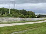
The Big Papio creek really did its job yesterday. Avoiding a catastrophic flood.
-
stormchaser
- Planning Board
- Posts: 2380
- Joined: Fri Jun 01, 2018 8:14 am
Re: 2024 Weather Thread
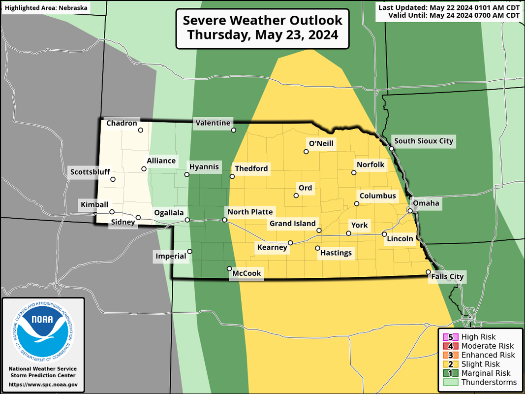
Unfortunately more severe weather is in the forecast for our area tomorrow. The SPC has us in a slight risk area (on the edge of it anyway) for a risk of damaging wind/hail.
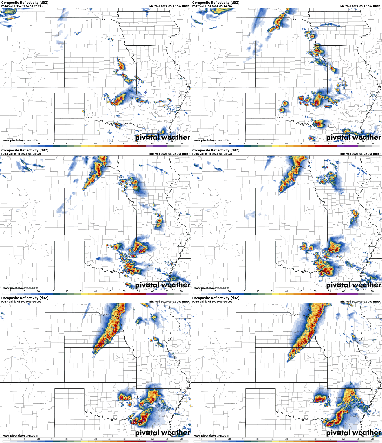
Based on short range models, it looks like we may get a round of scattered strong/severe storms during the afternoon/early evening hours and then potential for an overnight damaging wind event.
This is the day 2 outlook from the SPC:
Here is a simulated radar from the 06z HRRR for tomorrow afternoon into tomorrow night (with the line of storms moving into Omaha around Midnight but timing can always change):
Possibly another tornado outbreak?
Then attention towards this coming Saturday where forecast models are depicting ANOTHER strong negatively titled low pressure that if it happens as depicted currently, will produce yet another tornado outbreak that "might" impact parts of our area (southern parts of NE especially).
This is something that will need to be watched very closely as medium and eventually short range models start picking up on this storm system.
Based on short range models, it looks like we may get a round of scattered strong/severe storms during the afternoon/early evening hours and then potential for an overnight damaging wind event.
This is the day 2 outlook from the SPC:
Here is a simulated radar from the 06z HRRR for tomorrow afternoon into tomorrow night (with the line of storms moving into Omaha around Midnight but timing can always change):
Possibly another tornado outbreak?
Then attention towards this coming Saturday where forecast models are depicting ANOTHER strong negatively titled low pressure that if it happens as depicted currently, will produce yet another tornado outbreak that "might" impact parts of our area (southern parts of NE especially).
This is something that will need to be watched very closely as medium and eventually short range models start picking up on this storm system.
-
thenewguy
- County Board
- Posts: 4332
- Joined: Fri Oct 19, 2007 9:50 pm
- Location: Council Bluffs
-
stormchaser
- Planning Board
- Posts: 2380
- Joined: Fri Jun 01, 2018 8:14 am
Re: 2024 Weather Thread
Yeah, hopefully with the Saturday system the risk will stay south of us as there "may be" some issues with getting moisture return/dewpoints that are high enough this far north in time - but its tough to say for sure yet.
-
thenewguy
- County Board
- Posts: 4332
- Joined: Fri Oct 19, 2007 9:50 pm
- Location: Council Bluffs
Re: 2024 Weather Thread
the cruddy part is that I'll be just west of Topeka for the weekend... Hopefully it goes east a waysstormchaser wrote: Wed May 22, 2024 9:55 amYeah, hopefully with the Saturday system the risk will stay south of us as there "may be" some issues with getting moisture return/dewpoints that are high enough this far north in time - but its tough to say for sure yet.

Go Cubs Go
-
Coyote
- City Council
- Posts: 34366
- Joined: Tue Nov 18, 2003 11:18 am
- Location: Aksarben Village
Re: 2024 Weather Thread
Almighty Tuna, do still work here?
Big Papio Creek swells after overnight rainfall
Big Papio Creek swells after overnight rainfall
-
almighty_tuna
- City Council
- Posts: 106375
- Joined: Tue Apr 13, 2004 1:34 pm
- Location: Somewhere between downtown and Colorado
Re: 2024 Weather Thread
No, I don't work at Channel 7, nor would you catch me wearing a tie.
-
stormchaser
- Planning Board
- Posts: 2380
- Joined: Fri Jun 01, 2018 8:14 am
Re: 2024 Weather Thread
Drone footage of the tornado that eventually hit Greenfield, IA
-
Busguy2010

- City Council
- Posts: 7328
- Joined: Sat Apr 09, 2011 7:32 pm
- Location: North Central Omaha
Re: 2024 Weather Thread
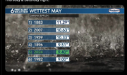
Turns out this is already the 5th wettest May on record. That's pretty significant. And still 9 days left.
-
Louie
- County Board
- Posts: 4936
- Joined: Fri Dec 23, 2011 4:23 pm
- Location: Dundee
Re: 2024 Weather Thread
Truly wild, and it is practically certain that it becomes the 4th within a couple days.Busguy2010 wrote: Wed May 22, 2024 11:51 am Turns out this is already the 5th wettest May on record. That's pretty significant. And still 9 days left.
-
Garrett

- County Board
- Posts: 4693
- Joined: Wed Nov 26, 2008 6:29 pm
- Location: New York City
Re: 2024 Weather Thread
That's one of the oddest tornados I've seen. It almost looks like a few tornados combined together occasionally breaching out?stormchaser wrote: Wed May 22, 2024 11:18 am Drone footage of the tornado that eventually hit Greenfield, IA
OMA-->CHI-->NYC
-
thenewguy
- County Board
- Posts: 4332
- Joined: Fri Oct 19, 2007 9:50 pm
- Location: Council Bluffs
Re: 2024 Weather Thread
i mean, we are only short of tying the record by 1.89 inches. If the last couple days has proved anything, it's that we could easily get that in a half hourLouie wrote: Wed May 22, 2024 11:58 amTruly wild, and it is practically certain that it becomes the 4th within a couple days.Busguy2010 wrote: Wed May 22, 2024 11:51 am Turns out this is already the 5th wettest May on record. That's pretty significant. And still 9 days left.
Go Cubs Go
-
thenewguy
- County Board
- Posts: 4332
- Joined: Fri Oct 19, 2007 9:50 pm
- Location: Council Bluffs
Re: 2024 Weather Thread
mesmerizing...Garrett wrote: Wed May 22, 2024 12:14 pmThat's one of the oddest tornados I've seen. It almost looks like a few tornados combined together occasionally breaching out?stormchaser wrote: Wed May 22, 2024 11:18 am Drone footage of the tornado that eventually hit Greenfield, IA
here's the count so far YTD

Go Cubs Go
-
stormchaser
- Planning Board
- Posts: 2380
- Joined: Fri Jun 01, 2018 8:14 am
Re: 2024 Weather Thread
They are known as "multiple vortex tornadoes" (which is also the type that hit Elkhorn back in April). Basically individual tornado vorticies inside one larger tornadic circulation. They're often the type of tornadoes where you'll see damage where one house can be completely destroyed and the neighbor house looks untouched.Garrett wrote: Wed May 22, 2024 12:14 pmThat's one of the oddest tornados I've seen. It almost looks like a few tornados combined together occasionally breaching out?stormchaser wrote: Wed May 22, 2024 11:18 am Drone footage of the tornado that eventually hit Greenfield, IA
-
Busguy2010
- City Council
- Posts: 7328
- Joined: Sat Apr 09, 2011 7:32 pm
- Location: North Central Omaha
Re: 2024 Weather Thread
I wouldn't doubt it one bit. The current NWS forecast adds over 1.25" over the next week, and if that pans out, would put this May at #2.thenewguy wrote: Wed May 22, 2024 12:28 pmi mean, we are only short of tying the record by 1.89 inches. If the last couple days has proved anything, it's that we could easily get that in a half hourLouie wrote: Wed May 22, 2024 11:58 amTruly wild, and it is practically certain that it becomes the 4th within a couple days.Busguy2010 wrote: Wed May 22, 2024 11:51 am Turns out this is already the 5th wettest May on record. That's pretty significant. And still 9 days left.
I have to wonder... Record keeping began about 150 years ago, if this May turns out top 5 or even 2 or 1, we're talking like a .02% or less chance of that happening over that period of time. When you quantify it like that, its unprecedented.
Further, I'd want to know where the month stacks up all time. There's probably only a handful of months out of about 2,000 that had over 10, 11, 12".
-
stormchaser
- Planning Board
- Posts: 2380
- Joined: Fri Jun 01, 2018 8:14 am
Re: 2024 Weather Thread
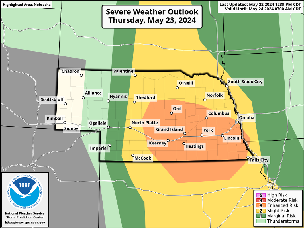
SPC has upgraded the risk for tomorrow to an "enhanced risk" and includes Omaha (barely). Our area is still for more of a damaging wind/large hail threat but areas west of us they have bumped up the tornado threat some.
-
Brad

- Photographer
- Posts: 1036557
- Joined: Sat Feb 28, 2004 6:03 pm
- Location: Omaha, NE
Re: 2024 Weather Thread
No more rain please... My basement can't take anymore!
My neighborhood near 90th and Center:
Wednesday 5/15/2024 we got 1.67"
Monday 5/20/2024 we got 1.18"
Tuesday 5/21/2024 we got 4.46"
That's a one week total of 7.31"
My neighborhood near 90th and Center:
Wednesday 5/15/2024 we got 1.67"
Monday 5/20/2024 we got 1.18"
Tuesday 5/21/2024 we got 4.46"
That's a one week total of 7.31"

Omaha Skyline Photos, Omaha Aerial Photos, and More.
Website: www.bradwilliamsphotography.com
Facebook: www.facebook.com/bradwilliamsphotography
Twitter: www.twitter.com/bradwphoto
Instagram: www.instagram.com/bradwilliamsphotography
YouTube: www.youtube.com/@bradwilliamsphoto
-
stormchaser
- Planning Board
- Posts: 2380
- Joined: Fri Jun 01, 2018 8:14 am
Re: 2024 Weather Thread
That's crazy - unfortunately more is on the way...Brad wrote: Wed May 22, 2024 2:24 pm No more rain please... My basement can't take anymore!
My neighborhood near 90th and Center:
Wednesday 5/15/2024 we got 1.67"
Monday 5/20/2024 we got 1.18"
Tuesday 5/21/2024 we got 4.46"
That's a one week total of 7.31"
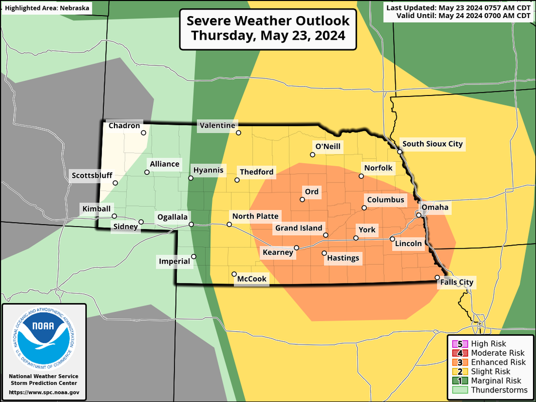
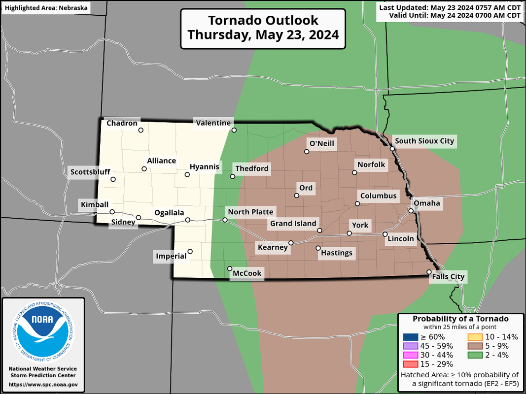
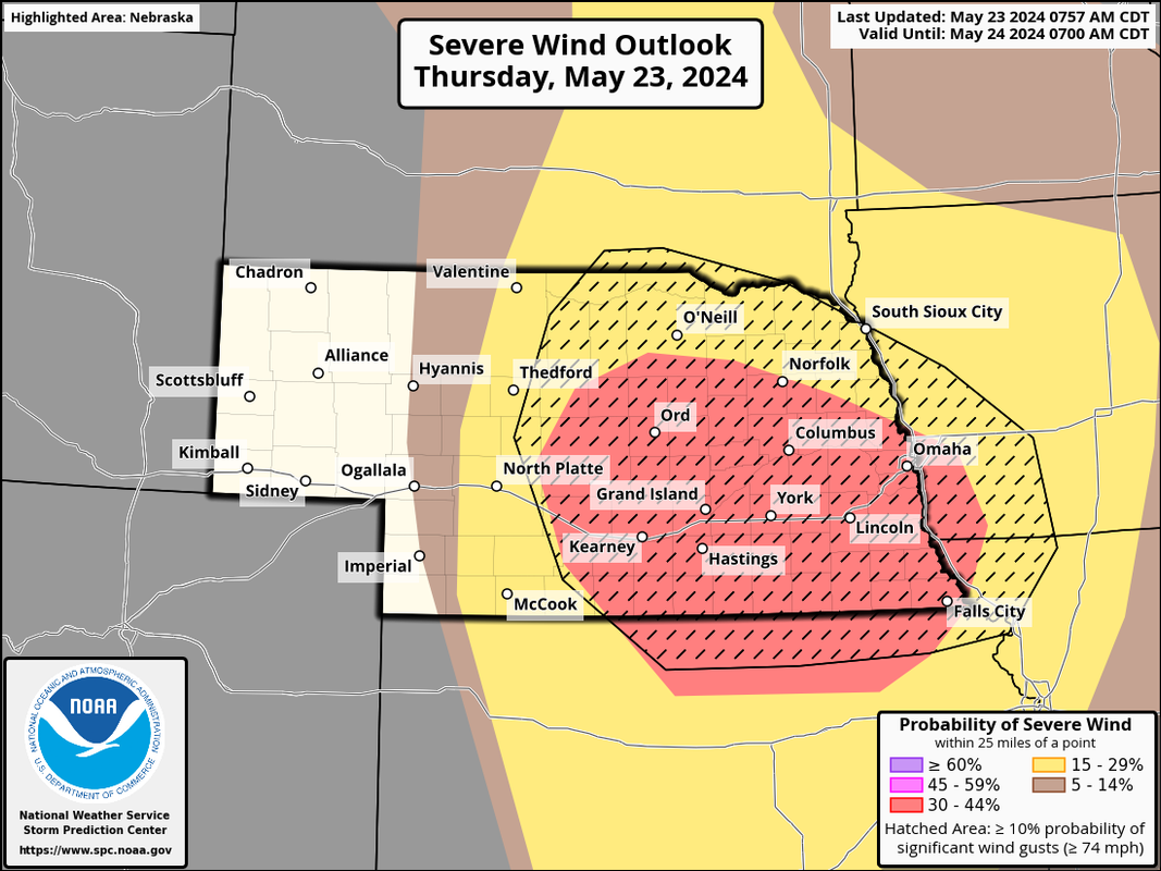
The threat for severe thunderstorms continues to increase for tonight. The SPC has expanded the "enhanced risk" (at least slightly) and added Omaha to a 5% tornado threat area. That said, the biggest threat tonight for Omaha anyway is the potential for a widespread damaging wind event as well as a few embedded tornadoes along the line of storms as they move into our area.
Night time, potentially rain wrapped tornadoes/QLCS tornadoes can obviously be very dangerous though they tend to be weaker - but still dangerous regardless.
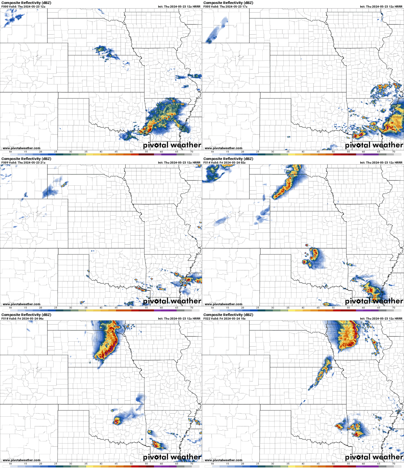
Based on short range models, sometime between 11 PM and 3 AM appears to be the most likely timeframe for storms to move into the Omaha area.
Latest SPC outlook showing Omaha more in the enhanced risk area (at least slightly more):
The 5% tornado risk area that now includes Omaha:
The damaging wind threat showing the potential for a widespread damaging wind event in our area:
Simulated radar based 12z HRRR from now until ~3 AM:
-
Busguy2010
- City Council
- Posts: 7328
- Joined: Sat Apr 09, 2011 7:32 pm
- Location: North Central Omaha
Re: 2024 Weather Thread
A very good chance were over 10" on the month after tonight's storms.
Also with this being an overnight threat, anybody know why I would have gotten the EAS alert on my phone for the flash flood warning, but not for the Tornado warnings the other day? It's a bit of a concern tonight because I'll definitely be asleep when the one tonight comes through, and I'm fairly confident it'll be significant straightline wind event and my bet is there'll be a tornado warning with it.
Does anybody know if I can check that somehow?
Also with this being an overnight threat, anybody know why I would have gotten the EAS alert on my phone for the flash flood warning, but not for the Tornado warnings the other day? It's a bit of a concern tonight because I'll definitely be asleep when the one tonight comes through, and I'm fairly confident it'll be significant straightline wind event and my bet is there'll be a tornado warning with it.
Does anybody know if I can check that somehow?
-
stormchaser
- Planning Board
- Posts: 2380
- Joined: Fri Jun 01, 2018 8:14 am
Re: 2024 Weather Thread
What kind of phone - and are you 100% sure you were inside the tornado warning polygon?Busguy2010 wrote: Thu May 23, 2024 11:54 am A very good chance were over 10" on the month after tonight's storms.
Also with this being an overnight threat, anybody know why I would have gotten the EAS alert on my phone for the flash flood warning, but not for the Tornado warnings the other day? It's a bit of a concern tonight because I'll definitely be asleep when the one tonight comes through, and I'm fairly confident it'll be significant straightline wind event and my bet is there'll be a tornado warning with it.
Does anybody know if I can check that somehow?
In my experience, the EAS notification on your phone frequently uses your coordinates based on GPS/cellular tower to determine if you're within the tornado warning polygon itself (not just the county that has the warning - the specific polygon that is warned which can be the northern half of a county for example). This way they can give more accurate warnings to the people at risk (even though they may sound the sirens for the entire county).
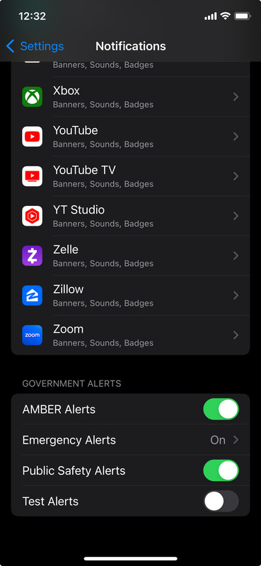
Since you received the flash flood warning, I'm assuming you have them enabled but to double-check (if you have an iPhone - Android is probably similar) go to:
Settings > Notifications > Then scroll all the way to the bottom and make sure you have the alerts enabled (like in the screenshot below):
-
Mr.Nuke
- Parks & Recreation
- Posts: 1217
- Joined: Tue May 08, 2007 10:12 pm
- Location: Omaha
Re: 2024 Weather Thread
Likely because like stormchaser hinted at you were probably outside of the Polygon for the tornado warning. the WEA system will only issue the warning to towers immediately in or that may potentially cover areas slightly outside of the polygon box.Busguy2010 wrote: Thu May 23, 2024 11:54 am Also with this being an overnight threat, anybody know why I would have gotten the EAS alert on my phone for the flash flood warning, but not for the Tornado warnings the other day?
The first warning early on Tuesday morning only covered far Northern Douglas county.
https://mesonet.agron.iastate.edu/vtec/ ... 2405211050
The second warning early Tuesday afternoon covered central Western Douglas County.
https://mesonet.agron.iastate.edu/vtec/ ... 2405211740
If you weren't in either of those areas you wouldn't get the WEA alert. If you want county wide alerts, I'd suggest running a weather app.
-
stormchaser
- Planning Board
- Posts: 2380
- Joined: Fri Jun 01, 2018 8:14 am
Re: 2024 Weather Thread
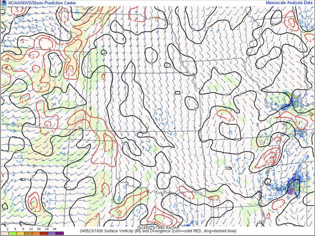
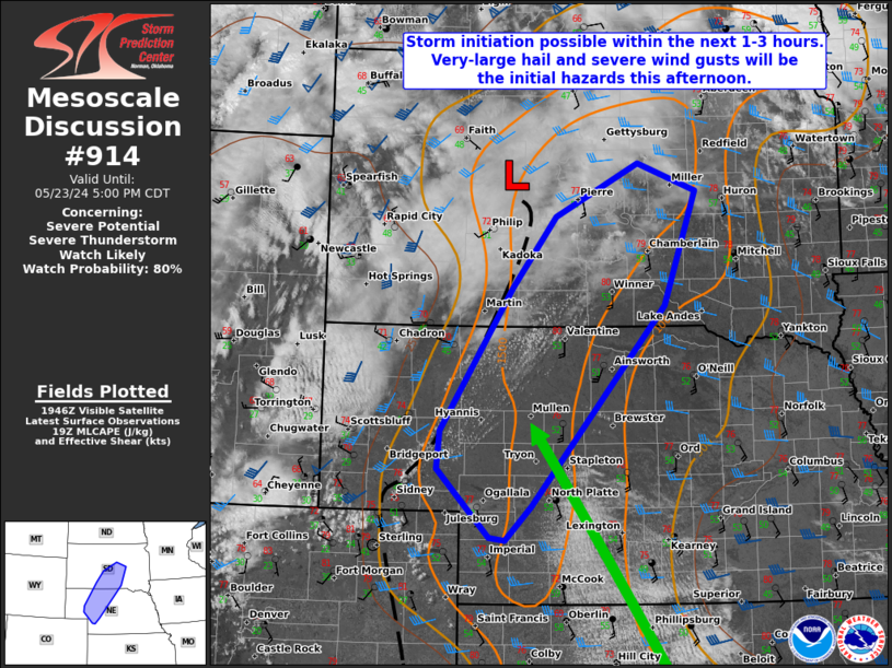
The atmosphere is starting to ramp up out in western NE and storm development should start occurring over the next few hours in the Sidney/Ogallala Nebraska area up towards Valentine. These will eventually be the storms that bring our severe weather tonight as they move this way.
Below you can see the area of forcing (basically the "trigger" to initiate storm development represented by the yellow/orangish shaded areas and red lines on the map below in western NE)
You can also see cumulus starting to organize along the boundary in that area as the forcing pushes in from the west based on visible satellite (as of ~1:45 PM).
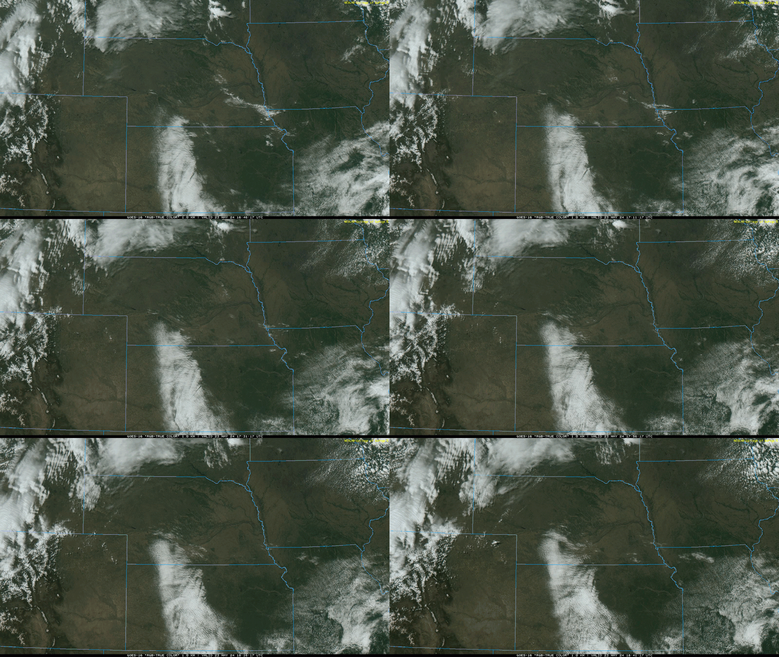
Below you can see the area of forcing (basically the "trigger" to initiate storm development represented by the yellow/orangish shaded areas and red lines on the map below in western NE)
You can also see cumulus starting to organize along the boundary in that area as the forcing pushes in from the west based on visible satellite (as of ~1:45 PM).
-
Busguy2010
- City Council
- Posts: 7328
- Joined: Sat Apr 09, 2011 7:32 pm
- Location: North Central Omaha
Re: 2024 Weather Thread
Good point guys about the polygon. I didn't know they were THAT specific on location, I just assumed since it was for Douglas County, and the sirens went off, that I'd get the alert, too. I was just confused as to why I would have gotten the flash flood warning, but not the tornado warnings. I probably technically was outside the polygon. And I do have them enabled, I made sure.
Although I was only JUST outside the afternoon one, and had it been extended, I would have definitely been in it. I'm 95% certain I saw the circulation they were watching go directly over my house, but by that time it only amounted to some swirling wind gusts at ground level, nothing serious.
Although I was only JUST outside the afternoon one, and had it been extended, I would have definitely been in it. I'm 95% certain I saw the circulation they were watching go directly over my house, but by that time it only amounted to some swirling wind gusts at ground level, nothing serious.
-
stormchaser
- Planning Board
- Posts: 2380
- Joined: Fri Jun 01, 2018 8:14 am
Re: 2024 Weather Thread
Yeah, they should probably make some more awareness about that so people don't get confused.
Could easily be that the meso/rotating wall cloud moved over you even if the warning wasn't extended - I've seen well over a dozen tornadoes that were either completely unwarned or didn't have a warning until they had been on the ground for several minutes (even when reporting it immediately to the NWS).
Omaha mostly dodged a bullet because in this case the earlier precip/heavy rain had stabilized the lower levels just enough to prevent anything tornadic from forming in our area. Once the storms got over by Red Oak, etc that was less of an issue.
Could easily be that the meso/rotating wall cloud moved over you even if the warning wasn't extended - I've seen well over a dozen tornadoes that were either completely unwarned or didn't have a warning until they had been on the ground for several minutes (even when reporting it immediately to the NWS).
Omaha mostly dodged a bullet because in this case the earlier precip/heavy rain had stabilized the lower levels just enough to prevent anything tornadic from forming in our area. Once the storms got over by Red Oak, etc that was less of an issue.
-
stormchaser
- Planning Board
- Posts: 2380
- Joined: Fri Jun 01, 2018 8:14 am
Re: 2024 Weather Thread
...and so it begins
-
Louie
- County Board
- Posts: 4936
- Joined: Fri Dec 23, 2011 4:23 pm
- Location: Dundee
Re: 2024 Weather Thread
The polygon warnings are a relatively new thing aren't they?stormchaser wrote: Thu May 23, 2024 3:04 pm Yeah, they should probably make some more awareness about that so people don't get confused.
Could easily be that the meso/rotating wall cloud moved over you even if the warning wasn't extended - I've seen well over a dozen tornadoes that were either completely unwarned or didn't have a warning until they had been on the ground for several minutes (even when reporting it immediately to the NWS).
Omaha mostly dodged a bullet because in this case the earlier precip/heavy rain had stabilized the lower levels just enough to prevent anything tornadic from forming in our area. Once the storms got over by Red Oak, etc that was less of an issue.
-
stormchaser
- Planning Board
- Posts: 2380
- Joined: Fri Jun 01, 2018 8:14 am
Re: 2024 Weather Thread
I'm honestly not sure but apparently they started using them back in 2007 already based on this link:
http://weatherwarn.com/polygon-activati ... %20weather.
-
stormchaser
- Planning Board
- Posts: 2380
- Joined: Fri Jun 01, 2018 8:14 am
Re: 2024 Weather Thread
Models have been pretty consistent in showing areas just barely north of Omaha getting hit the hardest by this damaging wind event - that's a pretty crazy looking bow being depicted. Along the bow (shown below) is where the potential for 80+ mph winds will exist. Who knows though, it easily could end up in Omaha too.
This aligns with visible satellite showing a boundary/warm font sliding up into that area (with a few cells developing along it just east of Omaha currently).
This is the latest simulated radar loop showing the bow passing just north of us after midnight tonight (probably around 2 AM roughly).
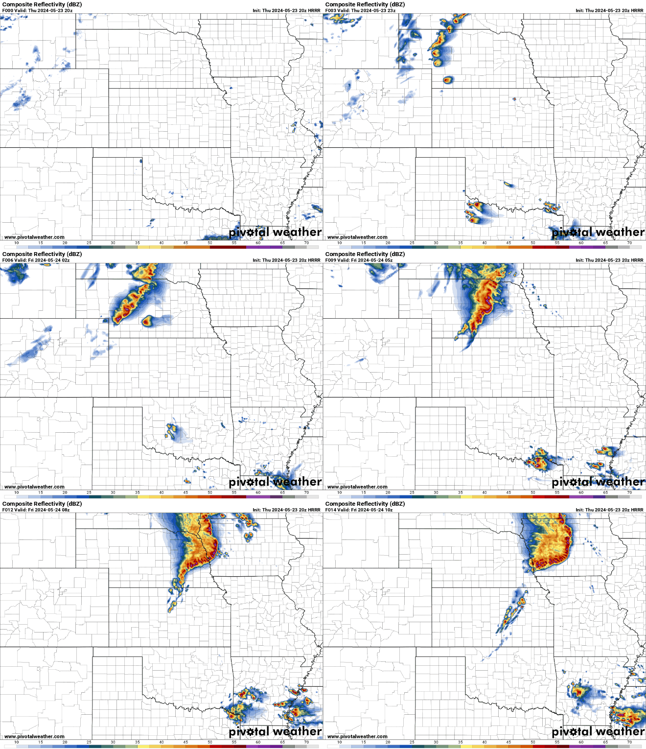
This aligns with visible satellite showing a boundary/warm font sliding up into that area (with a few cells developing along it just east of Omaha currently).
This is the latest simulated radar loop showing the bow passing just north of us after midnight tonight (probably around 2 AM roughly).
-
ShawJ
- Parks & Recreation
- Posts: 1573
- Joined: Wed Jan 31, 2007 5:58 pm
Re: 2024 Weather Thread
Having storms pop up out of nowhere with little warning is always tough, but seeing a line of storms develop hundreds of miles away and knowing they're heading your way is almost just as miserable. 
-
stormchaser
- Planning Board
- Posts: 2380
- Joined: Fri Jun 01, 2018 8:14 am
Re: 2024 Weather Thread
Pretty concerned that if Omaha gets hit with damaging wind at the level we “might” get hit (it’ll be close), the tree damage is going to be catastrophic. With the amount of rain we’ve had lately, the ground is very soft. It isn’t going to take much to knock down a LARGE number of trees…
So far what’s happening out by North Platte is playing out almost exactly as depicted with short range models with tornadic supercells now transitioning into more of a damaging wind event and starting to turn this direction.
Hope everyone is ready for a rough night…
So far what’s happening out by North Platte is playing out almost exactly as depicted with short range models with tornadic supercells now transitioning into more of a damaging wind event and starting to turn this direction.
Hope everyone is ready for a rough night…
-
stormchaser
- Planning Board
- Posts: 2380
- Joined: Fri Jun 01, 2018 8:14 am
Re: 2024 Weather Thread
I hear you.ShawJ wrote: Thu May 23, 2024 7:33 pm Having storms pop up out of nowhere with little warning is always tough, but seeing a line of storms develop hundreds of miles away and knowing they're heading your way is almost just as miserable.
With forecasting these events (and the bigger tornado events), it can sometimes be pretty miserable knowing with a decent amount of certainty what is probably about to happen (sometimes several days in advance) and being helpless to do much about it aside from trying to inform people.
It can feel like watching a disaster unfold in SUPER slow motion sometimes and it can easily make you feel sick to your stomach.
-
Busguy2010
- City Council
- Posts: 7328
- Joined: Sat Apr 09, 2011 7:32 pm
- Location: North Central Omaha
Re: 2024 Weather Thread
I honestly was feeling shades of the storm on July 10th, 2021. Both that it'll happen in early morning, and that the wind threat looks significant. I haven't checked the radar yet, don't know where it's at or how impressive.stormchaser wrote: Thu May 23, 2024 8:11 pm Pretty concerned that if Omaha gets hit with damaging wind at the level we “might” get hit (it’ll be close), the tree damage is going to be catastrophic. With the amount of rain we’ve had lately, the ground is very soft. It isn’t going to take much to knock down a LARGE number of trees…
So far what’s happening out by North Platte is playing out almost exactly as depicted with short range models with tornadic supercells now transitioning into more of a damaging wind event and starting to turn this direction.
Hope everyone is ready for a rough night…
-
Busguy2010
- City Council
- Posts: 7328
- Joined: Sat Apr 09, 2011 7:32 pm
- Location: North Central Omaha
Re: 2024 Weather Thread
Hmm, well it doesn't look impressive now, but I'm sure that'll change. Still got 2,3,4 hours to go.
-
stormchaser
- Planning Board
- Posts: 2380
- Joined: Fri Jun 01, 2018 8:14 am
Re: 2024 Weather Thread
They should get stronger in the next few hours and start to bow out more but they’re already producing 70mph wind (radar estimated anyway). That’s plenty strong to take down at least some trees here probably.Busguy2010 wrote: Thu May 23, 2024 10:52 pm Hmm, well it doesn't look impressive now, but I'm sure that'll change. Still got 2,3,4 hours to go.
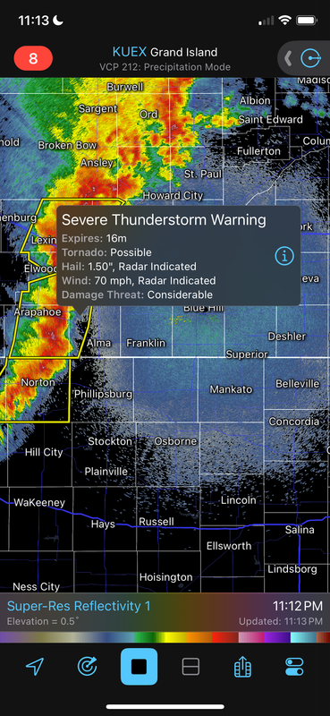
-
Busguy2010
- City Council
- Posts: 7328
- Joined: Sat Apr 09, 2011 7:32 pm
- Location: North Central Omaha
Re: 2024 Weather Thread
It's starting to form up. Guessing based on its current location, arrival time would be around 3am. I want to stay up but I can't. Just crossing my fingers now.