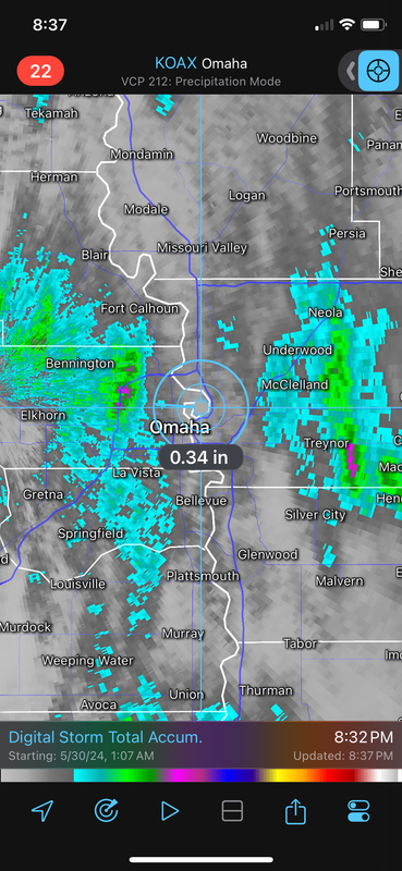
Horse |expletive|! I don't care if Eppley doesn't make it, for all intents and purposes this was historically the wettest May in Omaha ever. Most of the city got well over what we needed to break the record. I'm going to remember it as #1. This May as a whole might go in the events to remember thread. Between all the storm's, I mean I'm gonna have to go back and review it, but we had how many different significant events packaged into one memorable month. I can't even remember them all atm.
Cermak wrote: Thu May 30, 2024 4:09 pm
I’m up in NW Omaha approximately 100th st and West Maple around 4pm . They are getting dumped on up here easily a couple inches at least, some minor street flooding.
I got an inch this afternoon 114th and W. Center area. I was in NW Omaha around I-680 and W. Maple this afternoon pretty sure they got more than an inch. About as hard as I’ve seen it rain in a while, no wind at all and just occasional pee size hail.
Cermak wrote: Thu May 30, 2024 4:09 pm
I’m up in NW Omaha approximately 100th st and West Maple around 4pm . They are getting dumped on up here easily a couple inches at least, some minor street flooding.
I got an inch this afternoon 114th and W. Center area. I was in NW Omaha around I-680 and W. Maple this afternoon pretty sure they got more than an inch. About as hard as I’ve seen it rain in a while, no wind at all and just occasional pee size hail.
Looks like the area northeast of 680 & Maple got over 2.3" today and 14.5" for the month according to a couple weather stations in the area. West and South of it got around 1.7".
We will see what we get for rain totals here today with some steadier rain trying to move into the metro from south/southeast of town - so "maybe" there is a chance we'll still officially break the record.
Well see. I think it'll be close. We have less than .2" to get there. The NWS has us RIGHT there after today, though they had it raining by now. Plenty out west on radar, just has to hold over.
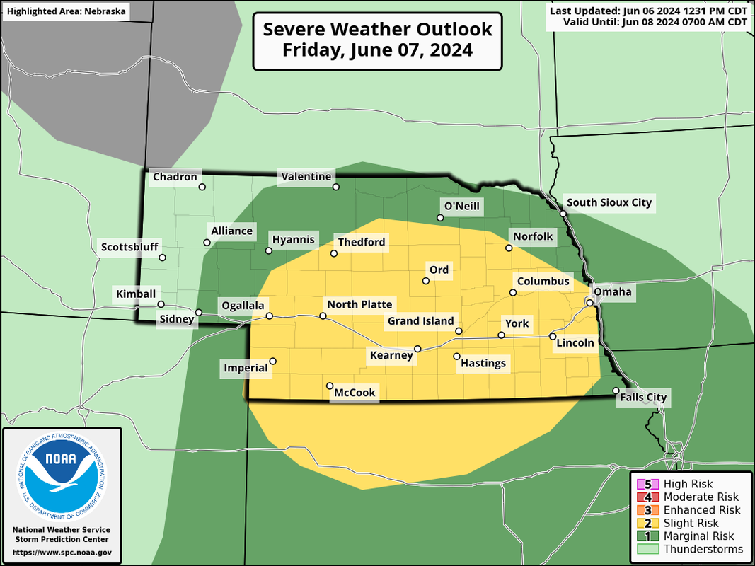
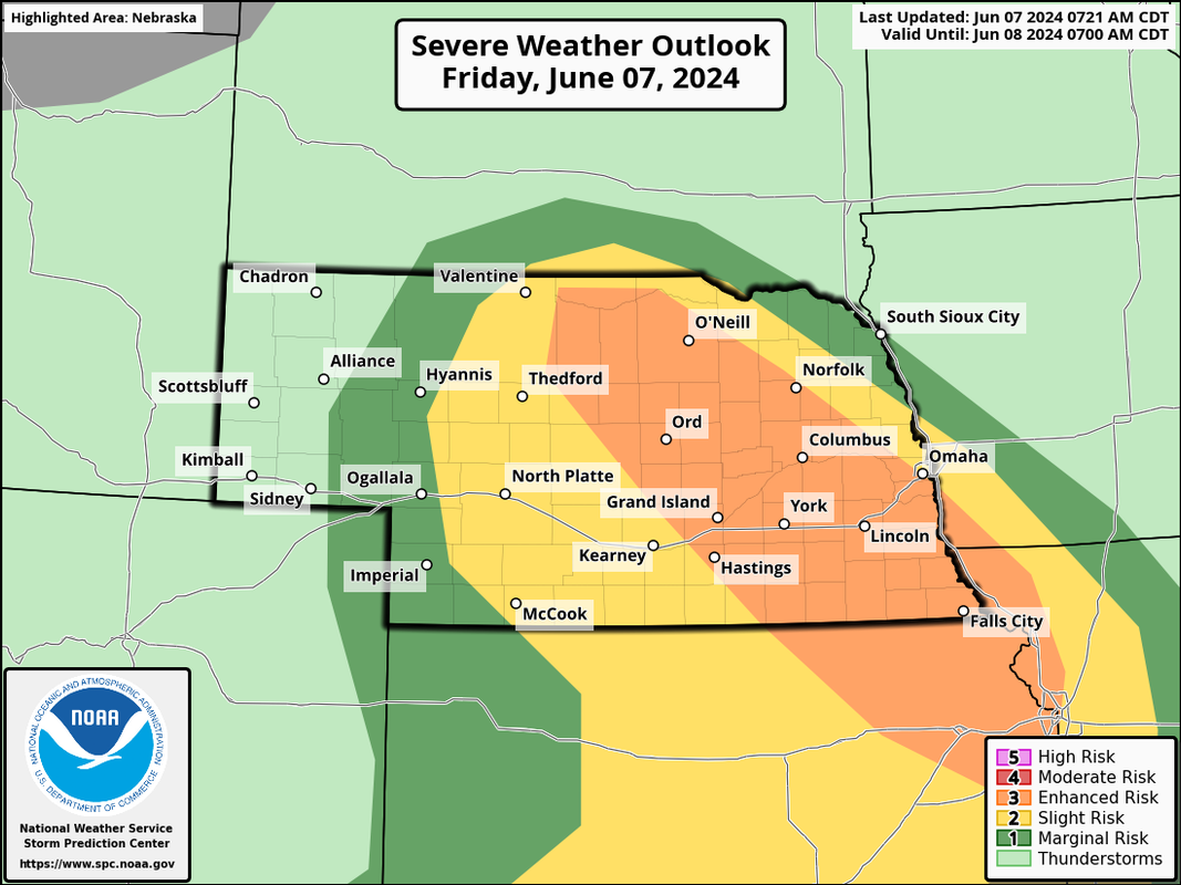
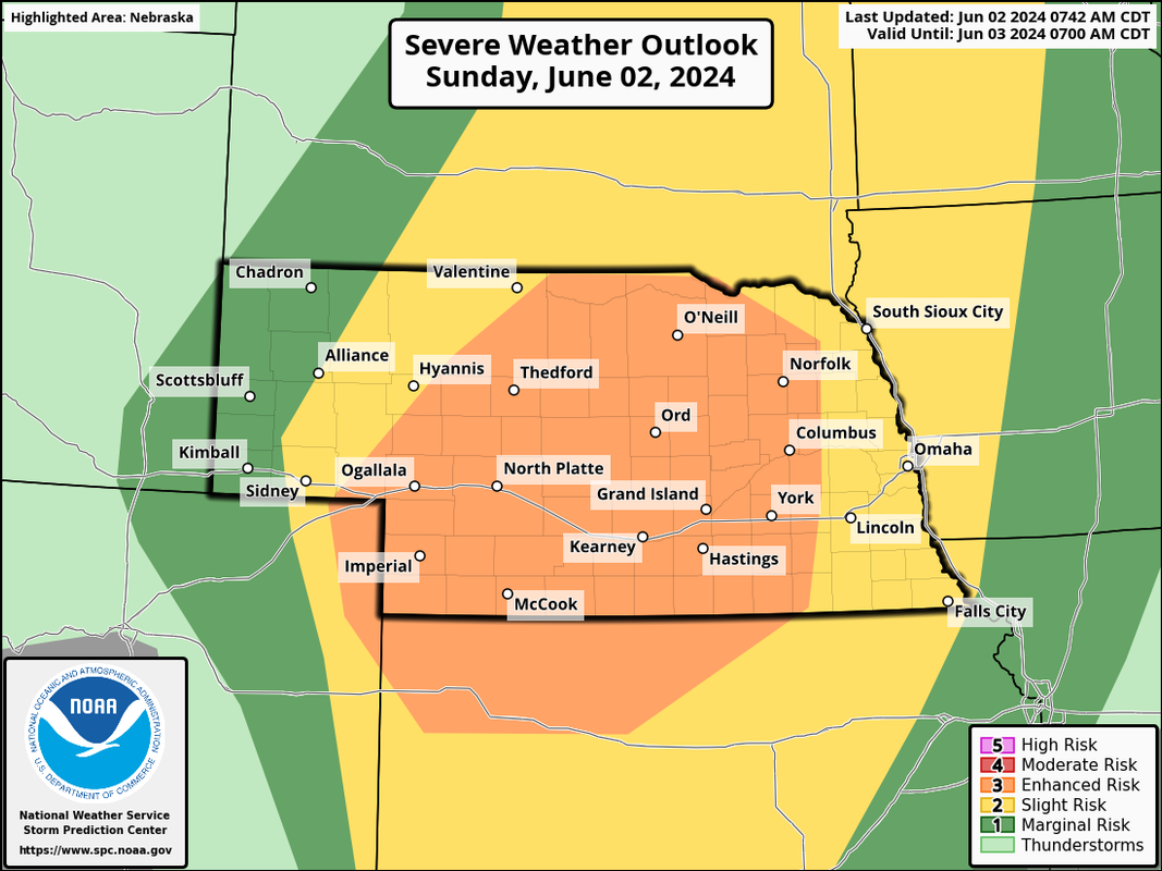
Much of Nebraska is in an "enhanced risk" for severe weather today (west of Omaha) for primarily a risk of damaging wind/hail though a few tornadoes will be possible as well.
There is a slight risk here in Omaha - with potential for damaging wind/hail this evening though storms will probably be weakening some as they move into our area.
SPC outlook for today showing the enhanced risk west of Omaha:
ShawJ wrote: Sun Jun 02, 2024 7:54 pm
The storm out west looks very similar to the one we had in the middle of the night recently.
Yeah, biggest question is how much will be left of them by the time they get there though. We "might" get some damaging wind if they hold on long enough.
ShawJ wrote: Sun Jun 02, 2024 7:54 pm
The storm out west looks very similar to the one we had in the middle of the night recently.
Yeah, biggest question is how much will be left of them by the time they get there though. We "might" get some damaging wind if they hold on long enough.
That system dissolved surprisingly fast as it approached Omaha last night. Ah well.
ShawJ wrote: Sun Jun 02, 2024 7:54 pm
The storm out west looks very similar to the one we had in the middle of the night recently.
Yeah, biggest question is how much will be left of them by the time they get there though. We "might" get some damaging wind if they hold on long enough.
That system dissolved surprisingly fast as it approached Omaha last night. Ah well.
The afternoon storm did the exact same thing. There were artists that quit the art fair on Sunday after they looked at the radar and we ended up with nothing but a couple wind gusts...
Busguy2010 wrote: Fri May 31, 2024 3:20 pm
Well see. I think it'll be close. We have less than .2" to get there. The NWS has us RIGHT there after today, though they had it raining by now. Plenty out west on radar, just has to hold over.
So, what was the final, 'official' May rainfall total?
Busguy2010 wrote: Fri May 31, 2024 3:20 pm
Well see. I think it'll be close. We have less than .2" to get there. The NWS has us RIGHT there after today, though they had it raining by now. Plenty out west on radar, just has to hold over.
So, what was the final, 'official' May rainfall total?
11.14"
Eppley really missed most of what happened on Thursday and Friday. I thoroughly believe there's no way most of the metro didn't shatter that 11.29" mark that is the official record.
Still quite remarkable! Of all the months that have occurred since record keeping began approximately 150 years ago, there was about a .015% chance of having the second wettest May on record.
Busguy2010 wrote: Fri May 31, 2024 3:20 pm
Well see. I think it'll be close. We have less than .2" to get there. The NWS has us RIGHT there after today, though they had it raining by now. Plenty out west on radar, just has to hold over.
So, what was the final, 'official' May rainfall total?
11.14"
Eppley really missed most of what happened on Thursday and Friday. I thoroughly believe there's no way most of the metro didn't shatter that 11.29" mark that is the official record.
Still quite remarkable! Of all the months that have occurred since record keeping began approximately 150 years ago, there was about a .015% chance of having the second wettest May on record.
Busguy2010 wrote: Fri May 31, 2024 3:20 pm
Well see. I think it'll be close. We have less than .2" to get there. The NWS has us RIGHT there after today, though they had it raining by now. Plenty out west on radar, just has to hold over.
So, what was the final, 'official' May rainfall total?
11.14"
Eppley really missed most of what happened on Thursday and Friday. I thoroughly believe there's no way most of the metro didn't shatter that 11.29" mark that is the official record.
Still quite remarkable! Of all the months that have occurred since record keeping began approximately 150 years ago, there was about a .015% chance of having the second wettest May on record.
Definitely not a fan of hot and humid. So the gauntlet begins soon...
For now it's comfortable. I'm a big fan of the lows in the 50's and the free AC. But Ironically after last year being so dry, and that being my main complaint, I will take some dry weather for a while. Haven't been able to turn dirt for a whole month and my plants are definitely suffering from over watering.
Busguy2010 wrote: Wed Jun 05, 2024 9:45 am
Definitely not a fan of hot and humid. So the gauntlet begins soon...
For now it's comfortable. I'm a big fan of the lows in the 50's and the free AC. But Ironically after last year being so dry, and that being my main complaint, I will take some dry weather for a while. Haven't been able to turn dirt for a whole month and my plants are definitely suffering from over watering.
We haven’t used our AC yet, usually we’ve used it at least a few days by now.
I've used mine plenty already. Anything over 72 inside, I ain't holding out. I want to be comfortable. I figure I make up for it in the winter when I don't use my heater so much. I keep it at 62 or 64 tops. Well, that is if we even get a real winter anymore in the future.
I totally prefer fall, winter, and spring, because I run hot. I can take all my clothes off sometimes and still not be comfortable, even if its "only" 85ish (also very well can't go outside like that), but in the winter I couldn't care less about wearing sweat pants and multiple layers with a jacket inside the house. Honestly I start to become less happy with anything above the 60's outside. At the same time, I wouldnt have my passion of gardening if it weren't for warmer temps.
Potential is increasing for strong/severe storms in parts of eastern NE tomorrow including possibly the Lincoln/Omaha area.
The main risk looks like large hail/damaging wind though a few isolated tornadoes can't be ruled out. These storms will likely be supercellular and drop southeast into the area during the afternoon/evening hours tomorrow.
I'm leaning towards chasing today. Based on everything I've seen, I think there is a decent chance for a tornadic supercell (or 2) initiating in north central NE and traveling southeast towards Columbus/Lincoln this afternoon into this evening - or wherever that warm front ends up.
Certainly not a huge tornado outbreak or anything, but don't be shocked if there are a few tornadoes anyway - especially as the storm gets closer to Lincoln, the low level jet really kicks in after 7 PM so sometime between 7 PM and 9 PM things could get interesting.
Otherwise large hail and damaging wind will be a threat with these storms though they should be isolated and stay mostly west of Omaha (though we have some risk here too).
The biggest question really is if storms can be surface based enough - If temps get too high and dewpoints don't get high enough, the storms will probably be fairly elevated which would significantly reduce any tornado potential. Something to keep a close eye on.
Brad wrote: Fri Jun 07, 2024 8:23 am
Forecast sure has changed over the course of this week. Looks I will need to get the cars in to hail mode once again today...
Brad wrote: Fri Jun 07, 2024 8:23 am
Forecast sure has changed over the course of this week. Looks I will need to get the cars in to hail mode once again today...
I need to know, what is hail mode?
We have 3 cars, but only a 2 car garage. If its going to storm I use my floor jack and slide my vintage Volkswagen over to the middle of the garage, and then fold in the mirrors of the other two cars and pull them in on either side. I have a bout 2" between them and I need to crawl out the window of my car and over the VW to get out. Its tight but they all fit.
Brad wrote: Fri Jun 07, 2024 8:23 am
Forecast sure has changed over the course of this week. Looks I will need to get the cars in to hail mode once again today...
I need to know, what is hail mode?
We have 3 cars, but only a 2 car garage. If its going to storm I use my floor jack and slide my vintage Volkswagen over to the middle of the garage, and then fold in the mirrors of the other two cars and pull them in on either side. I have a bout 2" between them and I need to crawl out the window of my car and over the VW to get out. Its tight but they all fit.
That beats an insurance claim by a mile!
For the record NEBUGEATER does not equal BUGEATER !!!!!!!
Brad wrote: Fri Jun 07, 2024 8:23 am
Forecast sure has changed over the course of this week. Looks I will need to get the cars in to hail mode once again today...
I need to know, what is hail mode?
We have 3 cars, but only a 2 car garage. If its going to storm I use my floor jack and slide my vintage Volkswagen over to the middle of the garage, and then fold in the mirrors of the other two cars and pull them in on either side. I have a bout 2" between them and I need to crawl out the window of my car and over the VW to get out. Its tight but they all fit.
Brad wrote: Fri Jun 07, 2024 8:23 am
Forecast sure has changed over the course of this week. Looks I will need to get the cars in to hail mode once again today...
I need to know, what is hail mode?
We have 3 cars, but only a 2 car garage. If its going to storm I use my floor jack and slide my vintage Volkswagen over to the middle of the garage, and then fold in the mirrors of the other two cars and pull them in on either side. I have a bout 2" between them and I need to crawl out the window of my car and over the VW to get out. Its tight but they all fit.
Brad wrote: Fri Jun 07, 2024 8:23 am
Forecast sure has changed over the course of this week. Looks I will need to get the cars in to hail mode once again today...
I need to know, what is hail mode?
We have 3 cars, but only a 2 car garage. If its going to storm I use my floor jack and slide my vintage Volkswagen over to the middle of the garage, and then fold in the mirrors of the other two cars and pull them in on either side. I have a bout 2" between them and I need to crawl out the window of my car and over the VW to get out. Its tight but they all fit.
Oh man, what a pain, but at least they fit!
Yeah, I have the same issue but I have 2 cars with a single car garage. Fun stuff.
Still looking like primarily a damaging wind/hail event in our area with the main risk probably just barely west of Omaha for what might end up being a pretty significant damaging wind event. It'll be cutting it close in Omaha - but Lincoln on west for sure things are likely going to be rough this evening.
Main tornado threat is going to probably stay further north along the warm front into north central NE. However, dewpoints aren't great in that area so probably not a huge tornado threat today. As these storms start turning more southeasterly, they should produce some amazing sculpted supercellurlar structure (aka "mother ships") with some areas of giant hail and at least some tornado risk (albeit mostly brief stuff).
Then as the storms move southeast and get closer to the I-80 corridor, they should grow upscale into more of a QLCS/bow storm structure and become mostly damaging wind producers (with some hail threat too).
My wife and son are headed to camp out near Fremont this evening. Is it looking bad for that area? I know earlier Rusty Lord mentioned that most of the severe stuff may end up further west and south of the metro.










 …
…