
Photographer
Posts: 1036693
Joined: Sun Feb 29, 2004 12:03 am
Location: Omaha, NE
Photographer
So I made a post ealier in the Weather Thread, but after doing some digging, this probably requires its own thread?
You do not have the required permissions to view the files attached to this post.

Omaha Skyline Photos, Omaha Aerial Photos, and More.
Website: www.bradwilliamsphotography.com
Facebook: www.facebook.com/bradwilliamsphotography
Twitter: www.twitter.com/bradwphoto
Instagram: www.instagram.com/bradwilliamsphotography
YouTube: www.youtube.com/@bradwilliamsphoto
Photographer
Posts: 1036693
Joined: Sun Feb 29, 2004 12:03 am
Location: Omaha, NE
Photographer
The Missouri River in Omaha is now expected to crest 981.6, which could go higher with all the rain tonight. 981.6 would also put it in the Moderate Flooding.
981.6 will flood Tom Hanafan Park. The main park area will be about 1.6" below water
981.6 will flood the marina and sculpture next to it on the Omaha Riverfront. The concrete area around the sculpture will have about 4 feet of water around it.
981.6 will flood Tom Hanafan Park. The main park area will be about 1.6" below water
981.6 will flood the marina and sculpture next to it on the Omaha Riverfront. The concrete area around the sculpture will have about 4 feet of water around it.
You do not have the required permissions to view the files attached to this post.
Omaha Skyline Photos, Omaha Aerial Photos, and More.
Website: www.bradwilliamsphotography.com
Facebook: www.facebook.com/bradwilliamsphotography
Twitter: www.twitter.com/bradwphoto
Instagram: www.instagram.com/bradwilliamsphotography
YouTube: www.youtube.com/@bradwilliamsphoto
Photographer
Posts: 1036693
Joined: Sun Feb 29, 2004 12:03 am
Location: Omaha, NE
Photographer
Also, I believe 981.6 is less 2 feet from closing I29.
Omaha Skyline Photos, Omaha Aerial Photos, and More.
Website: www.bradwilliamsphotography.com
Facebook: www.facebook.com/bradwilliamsphotography
Twitter: www.twitter.com/bradwphoto
Instagram: www.instagram.com/bradwilliamsphotography
YouTube: www.youtube.com/@bradwilliamsphoto

County Board
Posts: 4623
Joined: Mon Jun 13, 2005 2:52 am
Location: Land o Lakes, FL
County Board
I am up in the Sioux Falls area and it has been raining heavily at times in the area. I have seen reports of 6”-11” since Thursday. As of Saturday morning I-29 is closed south of Sioux Falls due to flooding. The detour they setup to get around this area is now closed due to flooding.
If you have ever been to the Falls in Sioux Falls it currently looks like raging rapids. Oh and all the water is coming to the Missouri River via the Big Sioux River
Falls Cam https://www.keloland.com/weather/live-cameras/
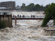
If you have ever been to the Falls in Sioux Falls it currently looks like raging rapids. Oh and all the water is coming to the Missouri River via the Big Sioux River
Falls Cam https://www.keloland.com/weather/live-cameras/
We are the people our parents warned us about.
Jimmy Buffett
Jimmy Buffett

IT Director
Posts: 10003421
Joined: Sat Aug 05, 2006 12:39 am
Location: West Central Omaha
IT Director
Heard it may flood starting Wednesday. My parents have a cabin in the Missouri up north and they are unable to boat and will be taking their dock out.

Human Relations
Posts: 833
Joined: Mon Apr 06, 2020 3:42 am
Location: Pisces–Cetus Supercluster Complex
Human Relations
Another example of why this site is better than local news.
Planning Board
Posts: 2380
Joined: Fri Jun 01, 2018 1:14 pm
Planning Board
My parents live in far northwest IA (about 30 miles southeast of Sioux Falls) and it’s a mess there too.Uffda wrote: ↑Sat Jun 22, 2024 12:54 pm I am up in the Sioux Falls area and it has been raining heavily at times in the area. I have seen reports of 6”-11” since Thursday. As of Saturday morning I-29 is closed south of Sioux Falls due to flooding. The detour they setup to get around this area is now closed due to flooding.
If you have ever been to the Falls in Sioux Falls it currently looks like raging rapids. Oh and all the water is coming to the Missouri River via the Big Sioux River
Falls Cam https://www.keloland.com/weather/live-cameras/
Flooding here as this all washes downstream in a few days is going to be interesting. Hopefully it doesn’t get too crazy but it might…
County Board
Posts: 4623
Joined: Mon Jun 13, 2005 2:52 am
Location: Land o Lakes, FL
County Board
Yes many small towns in NW Iowa have been affected. Inwood Rock Rapids, Hawarden and Spencer have all had flooded streets and downtowns.stormchaser wrote: ↑Sat Jun 22, 2024 8:28 pm
My parents live in far northwest IA (about 30 miles southeast of Sioux Falls) and it’s a mess there too.
Flooding here as this all washes downstream in a few days is going to be interesting. Hopefully it doesn’t get too crazy but it might…
Rain stopped Saturday afternoon but this water will take awhile to go down. I was planning to ride the Sioux Falls bike path while I was here but that mostly under water now.

We are the people our parents warned us about.
Jimmy Buffett
Jimmy Buffett
IT Director
Posts: 10003421
Joined: Sat Aug 05, 2006 12:39 am
Location: West Central Omaha
IT Director
I can't help but think of what stormchaser said a month ago:
stormchaser wrote: ↑Tue May 21, 2024 2:30 pmYep - in a way you could think of an extended drought almost as a “warning sign” kind of like when waters recede before a tsunami that a flood is going to happen - it’s just a matter of when…skinzfan23 wrote: ↑Tue May 21, 2024 2:26 pmI feel like that is what happened from the late 80's into the early 90's. It was really dry in the 80's and then the early 90's had a ton of flooding including 1993, when much of the midwest was under water.stormchaser wrote: ↑Tue May 21, 2024 2:23 pm
Actually you’d be surprised - it’s fairly common for droughts to “end” with floods. Usually it isn’t gradual - usually the weather pattern just changes and you go to the other extreme for a while…
Planning Board
Posts: 2380
Joined: Fri Jun 01, 2018 1:14 pm
Planning Board
Unfortunately it's a pattern that seems to repeat itself so like I said back then, no surprise but tragic regardless.BRoss wrote: ↑Sun Jun 23, 2024 3:14 pm I can't help but think of what stormchaser said a month ago:
stormchaser wrote: ↑Tue May 21, 2024 2:30 pmYep - in a way you could think of an extended drought almost as a “warning sign” kind of like when waters recede before a tsunami that a flood is going to happen - it’s just a matter of when…skinzfan23 wrote: ↑Tue May 21, 2024 2:26 pmI feel like that is what happened from the late 80's into the early 90's. It was really dry in the 80's and then the early 90's had a ton of flooding including 1993, when much of the midwest was under water.stormchaser wrote: ↑Tue May 21, 2024 2:23 pm
Actually you’d be surprised - it’s fairly common for droughts to “end” with floods. Usually it isn’t gradual - usually the weather pattern just changes and you go to the other extreme for a while…

City Council
Posts: 10828
Joined: Sat Apr 10, 2010 11:52 am
Location: Chicago
City Council
The river is already looking really full on the CWS drone shots and now the forecast is projecting a higher crest this week than the 2019 flood, making it the third highest in recorded history. If I remember right the 2019 floods were more prolonged and this is looking like a shorter-term event being back below flood levels by about the 4th, but definitely going to create problems.
County Board
Posts: 4623
Joined: Mon Jun 13, 2005 2:52 am
Location: Land o Lakes, FL
County Board
They shut down i29 north of Sioux City. Volunteer evacuation of Dakota Dunes and they are building a dike up there. Sioux River is predicted to be 10’ over record.
We are the people our parents warned us about.
Jimmy Buffett
Jimmy Buffett
Planning Board
Posts: 2380
Joined: Fri Jun 01, 2018 1:14 pm
Planning Board
12z 3km NAM is showing heavy rain for areas south of Omaha in the coming days. Not a good situation if this happens in those areas.
This map shows the depicted rain totals between now and Wednesday evening. To clarify, chances are this is over done as other models aren't showing this much rain - so "hopefully" it doesn't happen like this, but its something to keep an eye on.
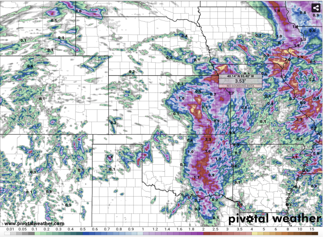
This map shows the depicted rain totals between now and Wednesday evening. To clarify, chances are this is over done as other models aren't showing this much rain - so "hopefully" it doesn't happen like this, but its something to keep an eye on.
County Board
Posts: 4623
Joined: Mon Jun 13, 2005 2:52 am
Location: Land o Lakes, FL
County Board
Looks like they will be opening i29 later tonight.
“Later on in the early morning (today) , the Big Sioux River crested at 44.9 feet, beating the current record by over seven feet and three feet higher than what was predicted by experts.
A levy has been built along Interstate 29 and currently houses the flood water as part of the emergency plan of North Sioux City. It is still unknown how many homes were lost on McCook Lake.”
https://www.keloland.com/news/local-new ... s-morning/
Last edited by Uffda on Mon Jun 24, 2024 7:54 pm, edited 1 time in total.
We are the people our parents warned us about.
Jimmy Buffett
Jimmy Buffett
County Board
Posts: 4623
Joined: Mon Jun 13, 2005 2:52 am
Location: Land o Lakes, FL
County Board
The residential area around McCook Lake, on the west side of i29 and just north of Dakota Dunes has heavy damage. I have driven on i29 thru there probably 100s of times and didn’t even realize there was a lake there seems to be an old oxbow of the Missouri. River.
We are the people our parents warned us about.
Jimmy Buffett
Jimmy Buffett
Planning Board
Posts: 2380
Joined: Fri Jun 01, 2018 1:14 pm
Planning Board
I-29 to I-680 north of Omaha is closing at ~11 AM...
https://www.ketv.com/article/interstate ... g/61307938
https://www.ketv.com/article/interstate ... g/61307938

New to the Neighborhood
Posts: 14
Joined: Thu Jun 09, 2022 3:46 am
New to the Neighborhood
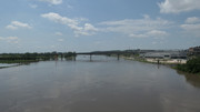
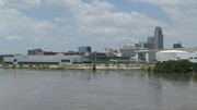
Flooding as of 11am on 6/25/24.

County Board
Posts: 4963
Joined: Fri Dec 23, 2011 10:23 pm
Location: Dundee
County Board
How much higher are they planning?
Photographer
Posts: 1036693
Joined: Sun Feb 29, 2004 12:03 am
Location: Omaha, NE
Photographer
Current = 28.9'
Forecasted Crest = 35.4'
Omaha Skyline Photos, Omaha Aerial Photos, and More.
Website: www.bradwilliamsphotography.com
Facebook: www.facebook.com/bradwilliamsphotography
Twitter: www.twitter.com/bradwphoto
Instagram: www.instagram.com/bradwilliamsphotography
YouTube: www.youtube.com/@bradwilliamsphoto
County Board
Posts: 4963
Joined: Fri Dec 23, 2011 10:23 pm
Location: Dundee
County Board

City Council
Posts: 11669
Joined: Mon Feb 09, 2004 5:26 pm
Location: Omaha/Bellevue
City Council
Any chance that the river crests lower than forecasted?
The only reason I am asking is they predicted it to be around 32.5 ft this morning and currently its just under 30.5. Obviously all the rain the metro received last night didn't help, but maybe /hopefully it will crest a few feet lower. (they did predict 35.4 and now its saying 35.1, so it did go down a little)
The only reason I am asking is they predicted it to be around 32.5 ft this morning and currently its just under 30.5. Obviously all the rain the metro received last night didn't help, but maybe /hopefully it will crest a few feet lower. (they did predict 35.4 and now its saying 35.1, so it did go down a little)
IT Director
Posts: 10003421
Joined: Sat Aug 05, 2006 12:39 am
Location: West Central Omaha
IT Director
A story yesterday said the crest is now a little later than first forecast.skinzfan23 wrote: ↑Wed Jun 26, 2024 1:31 pm Any chance that the river crests lower than forecasted?
The only reason I am asking is they predicted it to be around 32.5 ft this morning and currently its just under 30.5. Obviously all the rain the metro received last night didn't help, but maybe /hopefully it will crest a few feet lower. (they did predict 35.4 and now its saying 35.1, so it did go down a little)
https://www.ketv.com/article/officials- ... s/61414272Officials now predicting the river will crest in Council Bluffs around 1 p.m. Thursday
City Council
Posts: 11669
Joined: Mon Feb 09, 2004 5:26 pm
Location: Omaha/Bellevue
City Council
They did reduce it down to 34.9 from the previous high of 35.8 predicted at one point.
Photographer
Posts: 1036693
Joined: Sun Feb 29, 2004 12:03 am
Location: Omaha, NE
Photographer
Looks like it will be at that 34.9 until Saturday now.skinzfan23 wrote: ↑Wed Jun 26, 2024 5:21 pm They did reduce it down to 34.9 from the previous high of 35.8 predicted at one point.
https://water.noaa.gov/gauges/OMHN1
Omaha Skyline Photos, Omaha Aerial Photos, and More.
Website: www.bradwilliamsphotography.com
Facebook: www.facebook.com/bradwilliamsphotography
Twitter: www.twitter.com/bradwphoto
Instagram: www.instagram.com/bradwilliamsphotography
YouTube: www.youtube.com/@bradwilliamsphoto
City Council
Posts: 10828
Joined: Sat Apr 10, 2010 11:52 am
Location: Chicago
City Council
Photographer
Posts: 1036693
Joined: Sun Feb 29, 2004 12:03 am
Location: Omaha, NE
Photographer
I went down tonight at shot a few photos.
You do not have the required permissions to view the files attached to this post.
Omaha Skyline Photos, Omaha Aerial Photos, and More.
Website: www.bradwilliamsphotography.com
Facebook: www.facebook.com/bradwilliamsphotography
Twitter: www.twitter.com/bradwphoto
Instagram: www.instagram.com/bradwilliamsphotography
YouTube: www.youtube.com/@bradwilliamsphoto
IT Director
Posts: 10003421
Joined: Sat Aug 05, 2006 12:39 am
Location: West Central Omaha
IT Director
Crazy, thanks for the shots!
City Council
Posts: 11669
Joined: Mon Feb 09, 2004 5:26 pm
Location: Omaha/Bellevue
City Council
Now the prediction is updated to 33.1 ft. That would be even better than the 35.
Photographer
Posts: 1036693
Joined: Sun Feb 29, 2004 12:03 am
Location: Omaha, NE
Photographer
When I flew out of Eppley this morning, I noticed Gifford Farm was under water.
When I flew back to Eppley this evening, I noticed I680 was under water.
When I flew back to Eppley this evening, I noticed I680 was under water.
Omaha Skyline Photos, Omaha Aerial Photos, and More.
Website: www.bradwilliamsphotography.com
Facebook: www.facebook.com/bradwilliamsphotography
Twitter: www.twitter.com/bradwphoto
Instagram: www.instagram.com/bradwilliamsphotography
YouTube: www.youtube.com/@bradwilliamsphoto
City Council
Posts: 11669
Joined: Mon Feb 09, 2004 5:26 pm
Location: Omaha/Bellevue
City Council
It does seem like the water is leveling off some. Still just under 32ft and expected to crest at 33.1 ft midday on Saturday.
Home Owners Association
Posts: 152
Joined: Mon Nov 28, 2016 4:45 am
Home Owners Association
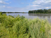
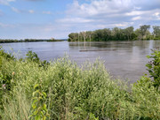
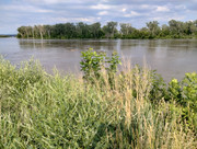
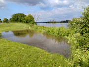
Here are a couple phone pics after work. I took them north looking south north of Gallop. The other is looking north of river city star. I think that view will be from the soccer stadium.
Home Owners Association
Posts: 152
Joined: Mon Nov 28, 2016 4:45 am
Home Owners Association


Home Owners Association
Posts: 152
Joined: Mon Nov 28, 2016 4:45 am
Home Owners Association
Home Owners Association
Posts: 152
Joined: Mon Nov 28, 2016 4:45 am
Home Owners Association
Too bad that Gallop couldn't do prairie in bloom north.
City Council
Posts: 11669
Joined: Mon Feb 09, 2004 5:26 pm
Location: Omaha/Bellevue
City Council
Looks like the river is already heading down after cresting just under 33ft. It has already gone down by about 7-8” today.
IT Director
Posts: 10003421
Joined: Sat Aug 05, 2006 12:39 am
Location: West Central Omaha
IT Director
Some pictures of I-29 from Iowa 511:
You do not have the required permissions to view the files attached to this post.