Welcome to the 2025 Weather Thread.
Latest update from the National Weather Service is showing up to an inch for tomorrow morning.

Photographer
Posts: 1036680
Joined: Sun Feb 29, 2004 12:03 am
Location: Omaha, NE
Photographer
You do not have the required permissions to view the files attached to this post.

Omaha Skyline Photos, Omaha Aerial Photos, and More.
Website: www.bradwilliamsphotography.com
Facebook: www.facebook.com/bradwilliamsphotography
Twitter: www.twitter.com/bradwphoto
Instagram: www.instagram.com/bradwilliamsphotography
YouTube: www.youtube.com/@bradwilliamsphoto

Home Owners Association
Posts: 191
Joined: Mon Mar 31, 2014 4:46 am
Home Owners Association
Looking much better than earlier forecasts - 1-2 inches was the initial call. This weekend appears to be forecasting lower as well.
Planning Board
Posts: 2380
Joined: Fri Jun 01, 2018 1:14 pm
Planning Board
This weekend's storm system is tracking further south so areas south of Omaha (from Nebraska City on south but especially as you get closer to the NE/KS border) could get hit pretty hard but "hopefully" here in Omaha, we only get relatively minor accumulations. Still need to watch closely though to make sure there aren't any sudden shifts back north but it's becoming increasingly likely it won't be a big deal here.
Planning Board
Posts: 2341
Joined: Thu Nov 29, 2018 7:02 pm
Planning Board
Not much snow overnight maybe a half inch in SW Omaha. Looks like Iowa will get the bulk of this 1-2 inches.
Last edited by Cermak on Thu Jan 02, 2025 4:11 pm, edited 1 time in total.
Planning Board
Posts: 2380
Joined: Fri Jun 01, 2018 1:14 pm
Planning Board
The 12z GFS has started to trend things back north for the storm this weekend as has the 12z NAM (at least for how far out you can see right now which includes only part of the storm so far). Not saying this is going to happen, but if the 12z ECMWF aligns when it come in over the next couple of hours and if trends continue on subsequent model runs, this storm may end up more impactful in Omaha than what is currently expected. If the trends continue, I'd expect them to expand the winter storm watch further north and "maybe" include Omaha. Since it's one model run, who knows but definitely something to watch closely.
Depicted snow totals based on the 12z GFS (which just came out). The totals are likely over done but still, impactful snowfall in Omaha IF things actually shift north:
**To clarify, the below map is NOT a forecast**
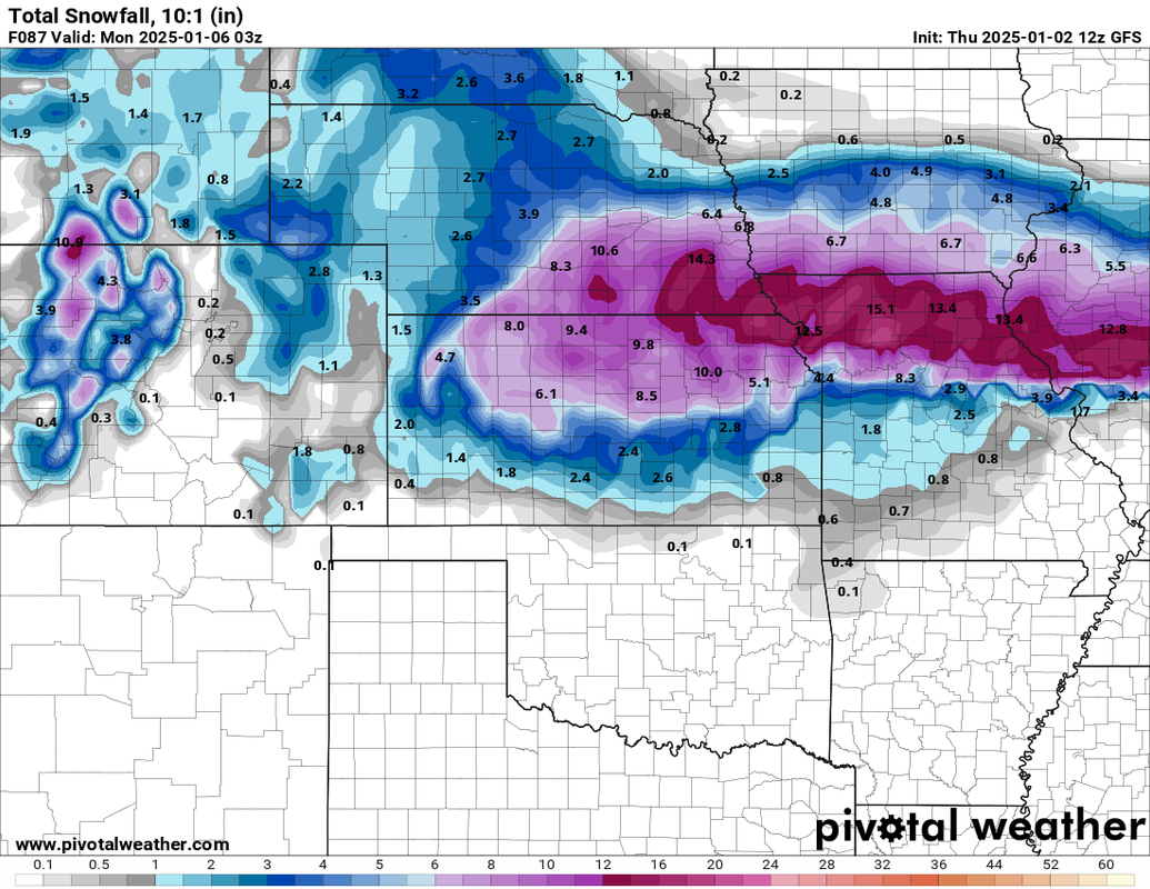
Depicted snow totals based on the 12z GFS (which just came out). The totals are likely over done but still, impactful snowfall in Omaha IF things actually shift north:
**To clarify, the below map is NOT a forecast**
Planning Board
Posts: 2380
Joined: Fri Jun 01, 2018 1:14 pm
Planning Board
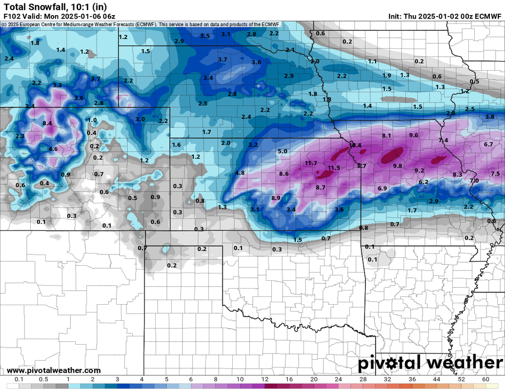
The 12z ECMWF is in and the trend north continues on this model as well. Right now, the heaviest snow is depicted to pass just south of Omaha on this one though - but definitely a shift north.
For reference, I've included the 00z run from last night and the 12z run from this morning below. As you can see, it shifted the heavier snow much closer to Omaha on the 12z run.
00z run:
12z run (the most recent update):
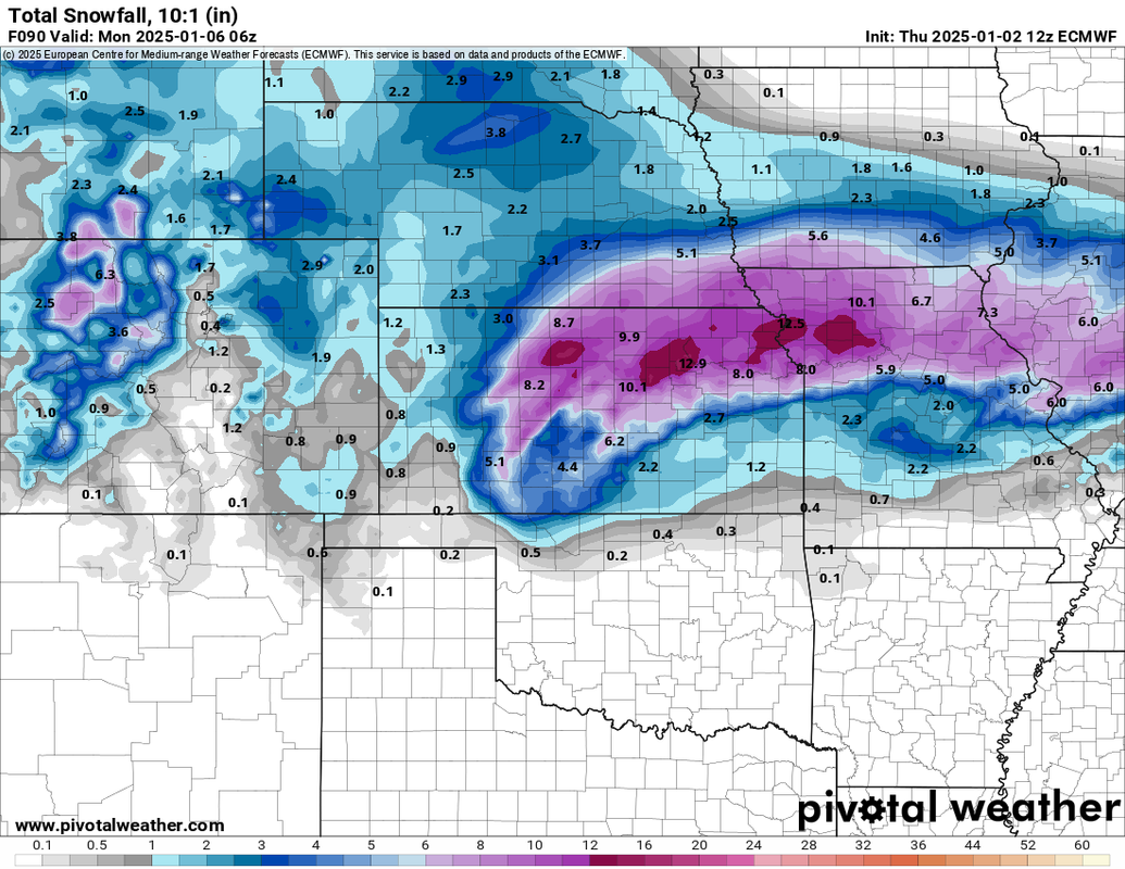
For reference, I've included the 00z run from last night and the 12z run from this morning below. As you can see, it shifted the heavier snow much closer to Omaha on the 12z run.
00z run:
12z run (the most recent update):
Planning Board
Posts: 2380
Joined: Fri Jun 01, 2018 1:14 pm
Planning Board
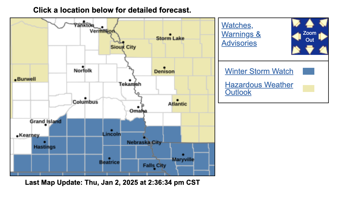
Not surprised, the NWS shifted the winter storm watch further north so now it's for just barely south of Omaha (and now includes Lincoln):
Planning Board
Posts: 2380
Joined: Fri Jun 01, 2018 1:14 pm
Planning Board
Looks like models have settled on track keeping the brunt of this storm south of Omaha and keeping us on the edge of the accumulating snow.
Unless something changes (like an additional shift north), it looks like 1-3 inches of snow for our area (IMO) starting Saturday night into Sunday with increasing amounts south of town.
Unless something changes (like an additional shift north), it looks like 1-3 inches of snow for our area (IMO) starting Saturday night into Sunday with increasing amounts south of town.
Planning Board
Posts: 2341
Joined: Thu Nov 29, 2018 7:02 pm
Planning Board
Good to know, I wouldn’t mind an inch or two.stormchaser wrote: ↑Fri Jan 03, 2025 11:55 am Looks like models have settled on track keeping the brunt of this storm south of Omaha and keeping us on the edge of the accumulating snow.
Unless something changes (like an additional shift north), it looks like 1-3 inches of snow for our area (IMO) starting Saturday night into Sunday with increasing amounts south of town.

The Don
Posts: 1013726
Joined: Wed Jan 07, 2004 11:31 am
Location: West Omaha
The Don
I’m fine with just an inch or 2 of snow..Cermak wrote: ↑Fri Jan 03, 2025 1:00 pmGood to know, I wouldn’t mind an inch or two.stormchaser wrote: ↑Fri Jan 03, 2025 11:55 am Looks like models have settled on track keeping the brunt of this storm south of Omaha and keeping us on the edge of the accumulating snow.
Unless something changes (like an additional shift north), it looks like 1-3 inches of snow for our area (IMO) starting Saturday night into Sunday with increasing amounts south of town.
Hopefully we avoid the brunt of freezing rain/ice elements…
Ciao..LiO…Peace
Go Cowboys!
Planning Board
Posts: 2380
Joined: Fri Jun 01, 2018 1:14 pm
Planning Board
Yeah, we might get a little but the majority of that should stay to the south of us also (unless something changes of course)Omaha Cowboy wrote: ↑Fri Jan 03, 2025 2:08 pmI’m fine with just an inch or 2 of snow..Cermak wrote: ↑Fri Jan 03, 2025 1:00 pmGood to know, I wouldn’t mind an inch or two.stormchaser wrote: ↑Fri Jan 03, 2025 11:55 am Looks like models have settled on track keeping the brunt of this storm south of Omaha and keeping us on the edge of the accumulating snow.
Unless something changes (like an additional shift north), it looks like 1-3 inches of snow for our area (IMO) starting Saturday night into Sunday with increasing amounts south of town.
Hopefully we avoid the brunt of freezing rain/ice elements…
Ciao..LiO…Peace
Planning Board
Posts: 2380
Joined: Fri Jun 01, 2018 1:14 pm
Planning Board
I should mention it's going to really come down to the exact track of this storm though as to how much snow we get. It'll have a very sharp cut off where 40 miles can be the difference between no snow and 6" of snow. Where that ends up will determine what ends up happening in Omaha since the cut off will be extremely close to here.
Home Owners Association
Posts: 191
Joined: Mon Mar 31, 2014 4:46 am
Home Owners Association
Looks like a Winter Weather Advisory has been issued from Noon Saturday to 6:00 p.m. Sunday:
* WHAT...Mixed precipitation expected. Total snow accumulations
between 1 and 3 inches and ice accumulations around a light glaze.
* WHERE...Portions of southwest Iowa and east central and northeast
Nebraska.
* WHEN...From noon Saturday to 6 PM CST Sunday.
* IMPACTS...Plan on slippery road conditions.
The Don
Posts: 1013726
Joined: Wed Jan 07, 2004 11:31 am
Location: West Omaha
The Don
And I know you’ll keep us posted..which is always appreciatedstormchaser wrote: ↑Fri Jan 03, 2025 2:22 pmYeah, we might get a little but the majority of that should stay to the south of us also (unless something changes of course)Omaha Cowboy wrote: ↑Fri Jan 03, 2025 2:08 pmI’m fine with just an inch or 2 of snow..Cermak wrote: ↑Fri Jan 03, 2025 1:00 pmGood to know, I wouldn’t mind an inch or two.stormchaser wrote: ↑Fri Jan 03, 2025 11:55 am Looks like models have settled on track keeping the brunt of this storm south of Omaha and keeping us on the edge of the accumulating snow.
Unless something changes (like an additional shift north), it looks like 1-3 inches of snow for our area (IMO) starting Saturday night into Sunday with increasing amounts south of town.
Hopefully we avoid the brunt of freezing rain/ice elements…
Ciao..LiO…Peace
 …
Ciao..LiO…Peace
Go Cowboys!
Planning Board
Posts: 2380
Joined: Fri Jun 01, 2018 1:14 pm
Planning Board
Yes sir, no problem. Precip is starting in the metro now….light snow currently in Millard.Omaha Cowboy wrote: ↑Sat Jan 04, 2025 7:31 pm And I know you’ll keep us posted..which is always appreciated
Ciao..LiO…Peace
Planning Board
Posts: 2380
Joined: Fri Jun 01, 2018 1:14 pm
Planning Board
Based on model trends and dry air placement over Omaha, the metro itself very well may end up getting basically no snow accumulation.
It’ll depend on the second/main wave of snow that develops and pushes in later tonight/tomorrow.
It’ll depend on the second/main wave of snow that develops and pushes in later tonight/tomorrow.
Planning Board
Posts: 2341
Joined: Thu Nov 29, 2018 7:02 pm
Planning Board
Just a trace at my house. We must of missed it. Kansas City getting hammered with blizzard.
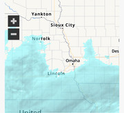
Omaha protected by Omadome.
Omaha protected by Omadome.

County Board
Posts: 6020
Joined: Fri Nov 12, 2004 8:46 pm
Location: Omaha and Puerto Vallarta
County Board
The OmaDome has made its reappearance.
Image from this morning.
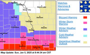
Image from this morning.
Photographer
Posts: 1036680
Joined: Sun Feb 29, 2004 12:03 am
Location: Omaha, NE
Photographer
Quite the difference! Going from 1 inch to 1 foot in 45 miles!

Omaha Skyline Photos, Omaha Aerial Photos, and More.
Website: www.bradwilliamsphotography.com
Facebook: www.facebook.com/bradwilliamsphotography
Twitter: www.twitter.com/bradwphoto
Instagram: www.instagram.com/bradwilliamsphotography
YouTube: www.youtube.com/@bradwilliamsphoto
Planning Board
Posts: 2341
Joined: Thu Nov 29, 2018 7:02 pm
Planning Board
16 inches in Falls City, apparently a dry pocket planted itself over Omaha completely blocking out the snow. While to the south of us they got dumped on. Really an impressive snowstorm one of the biggest on record.
Planning Board
Posts: 2650
Joined: Sun Nov 23, 2008 9:07 pm
Location: Omaha
Planning Board
So, are we officially back in a drought yet in the Omaha area?
He said "They are some big, ugly red brick buildings"
...and then they were gone.
...and then they were gone.
City Council
Posts: 7376
Joined: Sun Apr 10, 2011 12:32 am
Location: North Central Omaha
City Council
Most certainly. Probably have been for a while.
https://droughtmonitor.unl.edu/CurrentM ... or.aspx?NE
Planning Board
Posts: 2341
Joined: Thu Nov 29, 2018 7:02 pm
Planning Board
We are pretty much halfway through winter, and still not even an inch of snow this winter (Valley station), pretty amazing.
Library Board
Posts: 466
Joined: Thu Apr 09, 2020 1:55 pm
Library Board
The first half of 2024 was great for rain, but then the second half dried up. If you look up the map for July 2nd 2024, we had hardly any drought conditions.Busguy2010 wrote: ↑Thu Jan 16, 2025 12:58 pmMost certainly. Probably have been for a while.
https://droughtmonitor.unl.edu/CurrentM ... or.aspx?NE
Our ten day forecast doesn't look promising for anything in the immediate future, but maybe we'll get an earlier spring and with warmer air from the south hopefully more rain.
City Council
Posts: 11661
Joined: Mon Feb 09, 2004 5:26 pm
Location: Omaha/Bellevue
City Council
Yes, I hate driving in it, but we desperately need some snow, or at least some moisture. If we don't get any soon, it wouldn't be a bad idea to water any trees, shrubs you have if its warm enough for the water to be absorbed.
City Council
Posts: 7376
Joined: Sun Apr 10, 2011 12:32 am
Location: North Central Omaha
City Council
I dont recall exactly, but at some point I gave up keeping track. From 2020 on we managed to consistently be in over a 20" deficit, so what rain we got this spring really only got us less out of that deficit, and now we're basically back in that deficit. Maybe their parameters are reset each season or year for what's considered good moisture, i.e. not drought, but in my book at this moment we probably are behind about 15-20" since 2020. This spring proved no amount of rain is gonna dig it out of it, so maybe we're just becoming a more arid environment.Stan wrote: ↑Thu Jan 16, 2025 2:42 pmThe first half of 2024 was great for rain, but then the second half dried up. If you look up the map for July 2nd 2024, we had hardly any drought conditions.Busguy2010 wrote: ↑Thu Jan 16, 2025 12:58 pmMost certainly. Probably have been for a while.
https://droughtmonitor.unl.edu/CurrentM ... or.aspx?NE
Our ten day forecast doesn't look promising for anything in the immediate future, but maybe we'll get an earlier spring and with warmer air from the south hopefully more rain.
Library Board
Posts: 466
Joined: Thu Apr 09, 2020 1:55 pm
Library Board
It's gotta be more of the long term trend that is most meaningful. Getting out of that drought last year helped with the immediate need for flora, but long term impacts are probably still felt by less drought resistant trees. I'd also be concerned with the snowmelt refilling the aquifer and water levels as a result of that. Population of Colorado increasing and making them shore up more of the snow melt for themselves will impact our environment even further and make water rights a bigger topic than it currently is as a whole of our population.Busguy2010 wrote: ↑Thu Jan 16, 2025 4:55 pmI dont recall exactly, but at some point I gave up keeping track. From 2020 on we managed to consistently be in over a 20" deficit, so what rain we got this spring really only got us less out of that deficit, and now we're basically back in that deficit. Maybe their parameters are reset each season or year for what's considered good moisture, i.e. not drought, but in my book at this moment we probably are behind about 15-20" since 2020. This spring proved no amount of rain is gonna dig it out of it, so maybe we're just becoming a more arid environment.Stan wrote: ↑Thu Jan 16, 2025 2:42 pmThe first half of 2024 was great for rain, but then the second half dried up. If you look up the map for July 2nd 2024, we had hardly any drought conditions.Busguy2010 wrote: ↑Thu Jan 16, 2025 12:58 pmMost certainly. Probably have been for a while.
https://droughtmonitor.unl.edu/CurrentM ... or.aspx?NE
Our ten day forecast doesn't look promising for anything in the immediate future, but maybe we'll get an earlier spring and with warmer air from the south hopefully more rain.

Home Owners Association
Posts: 142
Joined: Wed Jan 24, 2007 10:20 pm
Location: Omaha
Home Owners Association
Isn't march our snowiest month?
Toto
Planning Board
Posts: 2650
Joined: Sun Nov 23, 2008 9:07 pm
Location: Omaha
Planning Board
Thanks Busguy2010 for posting the drought monitor. I bookmarked it now. I'm just worried the drought is going to get worse and we'll end up with a lot of dead vegetation becoming more susceptible to wildfires.
He said "They are some big, ugly red brick buildings"
...and then they were gone.
...and then they were gone.

Library Board
Posts: 284
Joined: Wed Nov 13, 2024 4:38 pm
Library Board
The National Weather Service informs us that February is Omaha's snowiest month. Source: Snow Drought.
You do not have the required permissions to view the files attached to this post.
Photographer
Posts: 1036680
Joined: Sun Feb 29, 2004 12:03 am
Location: Omaha, NE
Photographer
Watch out for those "Lionel Richie winds"... LOL!!!
Omaha Skyline Photos, Omaha Aerial Photos, and More.
Website: www.bradwilliamsphotography.com
Facebook: www.facebook.com/bradwilliamsphotography
Twitter: www.twitter.com/bradwphoto
Instagram: www.instagram.com/bradwilliamsphotography
YouTube: www.youtube.com/@bradwilliamsphoto
City Council
Posts: 106409
Joined: Tue Apr 13, 2004 6:34 pm
Location: Somewhere between downtown and Colorado
City Council
I nearly dropped that gif when I saw the post this morning! Been in my head ever since. 
Photographer
Posts: 1036680
Joined: Sun Feb 29, 2004 12:03 am
Location: Omaha, NE
Photographer
You should have. I'm surprised that not only are there no gifs posted in the comments, there's not even a single comment!almighty_tuna wrote: ↑Fri Jan 17, 2025 3:36 pm I nearly dropped that gif when I saw the post this morning! Been in my head ever since.
Omaha Skyline Photos, Omaha Aerial Photos, and More.
Website: www.bradwilliamsphotography.com
Facebook: www.facebook.com/bradwilliamsphotography
Twitter: www.twitter.com/bradwphoto
Instagram: www.instagram.com/bradwilliamsphotography
YouTube: www.youtube.com/@bradwilliamsphoto
City Council
Posts: 7376
Joined: Sun Apr 10, 2011 12:32 am
Location: North Central Omaha
City Council
Low dew point of -17 forecast during this cold stretch 


City Council
Posts: 106409
Joined: Tue Apr 13, 2004 6:34 pm
Location: Somewhere between downtown and Colorado
City Council
It's not the heat really, it's the humidity that gets ya
Planning Board
Posts: 2341
Joined: Thu Nov 29, 2018 7:02 pm
Planning Board
Pretty nasty out today and the next 3 days. Improving midweek.
City Council
Posts: 7376
Joined: Sun Apr 10, 2011 12:32 am
Location: North Central Omaha
City Council
Balmy.almighty_tuna wrote: ↑Sat Jan 18, 2025 3:59 pmIt's not the heat really, it's the humidity that gets ya

City Council
Posts: 10827
Joined: Sat Apr 10, 2010 11:52 am
Location: Chicago
City Council
Looks like New Orleans has gotten more snow than Omaha now.
The Don
Posts: 1013726
Joined: Wed Jan 07, 2004 11:31 am
Location: West Omaha
The Don
County Board
Posts: 4960
Joined: Fri Dec 23, 2011 10:23 pm
Location: Dundee
County Board
It appears the Great American Desert naming wasn't so far off