Also, the newest map is not the default view, You need to go to the clock icon to get to the newest view.
Google Maps & Google Earth
-
Brad

- Photographer
- Posts: 1036516
- Joined: Sat Feb 28, 2004 6:03 pm
- Location: Omaha, NE
Re: Google Maps & Google Earth

Omaha Skyline Photos, Omaha Aerial Photos, and More.
Website: www.bradwilliamsphotography.com
Facebook: www.facebook.com/bradwilliamsphotography
Twitter: www.twitter.com/bradwphoto
Instagram: www.instagram.com/bradwilliamsphotography
YouTube: www.youtube.com/@bradwilliamsphoto
-
skinzfan23

- City Council
- Posts: 11613
- Joined: Mon Feb 09, 2004 11:26 am
- Location: Omaha/Bellevue
Re: Google Maps & Google Earth
I accessed google earth on chrome, but don't see a clock. Where is that located.Brad wrote: Thu Jun 22, 2023 9:15 am
Also, the newest map is not the default view, You need to go to the clock icon to get to the newest view.
-
Brad
- Photographer
- Posts: 1036516
- Joined: Sat Feb 28, 2004 6:03 pm
- Location: Omaha, NE
Re: Google Maps & Google Earth
I didn't know there was a web based google earth. I have the program downloaded on my computer and then the clock is up at the top.skinzfan23 wrote: Thu Jun 22, 2023 12:12 pmI accessed google earth on chrome, but don't see a clock. Where is that located.Brad wrote: Thu Jun 22, 2023 9:15 am
Also, the newest map is not the default view, You need to go to the clock icon to get to the newest view.
Omaha Skyline Photos, Omaha Aerial Photos, and More.
Website: www.bradwilliamsphotography.com
Facebook: www.facebook.com/bradwilliamsphotography
Twitter: www.twitter.com/bradwphoto
Instagram: www.instagram.com/bradwilliamsphotography
YouTube: www.youtube.com/@bradwilliamsphoto
-
Cermak
- Planning Board
- Posts: 2322
- Joined: Thu Nov 29, 2018 1:02 pm
Re: Google Maps & Google Earth
Mine auto updated on my phone. They also included all the newer buildings on West Dodge like the Union Bank & Trust building in Heartwood Preserve. Hopefully we won't have to wait another 2 years for the next one.Brad wrote: Thu Jun 22, 2023 9:15 amAlso, the newest map is not the default view, You need to go to the clock icon to get to the newest view.
-
Brad
- Photographer
- Posts: 1036516
- Joined: Sat Feb 28, 2004 6:03 pm
- Location: Omaha, NE
Re: Google Maps & Google Earth
Someone is out mapping today…
Hopefully they got the northwest part of Elkhorn in a different flight. That’s the fastest growing ParkOmaha right now.
Hopefully they got the northwest part of Elkhorn in a different flight. That’s the fastest growing ParkOmaha right now.
You do not have the required permissions to view the files attached to this post.
Omaha Skyline Photos, Omaha Aerial Photos, and More.
Website: www.bradwilliamsphotography.com
Facebook: www.facebook.com/bradwilliamsphotography
Twitter: www.twitter.com/bradwphoto
Instagram: www.instagram.com/bradwilliamsphotography
YouTube: www.youtube.com/@bradwilliamsphoto
-
Busguy2010

- City Council
- Posts: 7316
- Joined: Sat Apr 09, 2011 7:32 pm
- Location: North Central Omaha
Re: Google Maps & Google Earth
Wow, I never knew that's how they did it. That would be a pretty kush job. Would take forever though and be repetitive. Like mowing a big lawn.
-
Busguy2010
- City Council
- Posts: 7316
- Joined: Sat Apr 09, 2011 7:32 pm
- Location: North Central Omaha
Re: Google Maps & Google Earth
I believe I just saw the plane in Central Omaha, maybe I wouldn't know, but it's just randomly flying over. May be headed to Millard airport
-
bbinks
- Parks & Recreation
- Posts: 1542
- Joined: Thu Sep 14, 2006 4:10 pm
Re: Google Maps & Google Earth
I thought this was all satellite images.
-
Brad
- Photographer
- Posts: 1036516
- Joined: Sat Feb 28, 2004 6:03 pm
- Location: Omaha, NE
Re: Google Maps & Google Earth
Google is a combination of both. And who knows if this one was for google anyways. There are several aerial photo mapping services. Most of the high quality images where you can zoom in and see lots of detail are from airplanes.
Omaha Skyline Photos, Omaha Aerial Photos, and More.
Website: www.bradwilliamsphotography.com
Facebook: www.facebook.com/bradwilliamsphotography
Twitter: www.twitter.com/bradwphoto
Instagram: www.instagram.com/bradwilliamsphotography
YouTube: www.youtube.com/@bradwilliamsphoto
-
Trips1
- Home Owners Association
- Posts: 133
- Joined: Thu Jan 13, 2022 11:21 am
Re: Google Maps & Google Earth
I noticed that Google Earth for Android updated with images from ~July 15th. This is for the area around 192nd and Harrison. That is a really quick turn around time.
-
mrsticka
- Planning Board
- Posts: 2496
- Joined: Sat Apr 07, 2012 12:31 am
- Location: Lincoln
Re: Google Maps & Google Earth
You know how you can look at past Street View imagery as far back as 2007? Well, what if someday, Google comes up with a way to look at Street View from the 90's, 80's, 70's, 60's, 50's and even further back?
-
Garrett

- County Board
- Posts: 4673
- Joined: Wed Nov 26, 2008 6:29 pm
- Location: New York City
Re: Google Maps & Google Earth
The closest they could get is uploading more archival photos but it would be next to impossible to do a full on street view without a degree of time travel haha. If you haven't yet, look at the DOGIS.org website, and then you can change the layers to historic imagery going as far back at the 1930s.mrsticka wrote: Fri Aug 25, 2023 8:31 pm You know how you can look at past Street View imagery as far back as 2007? Well, what if someday, Google comes up with a way to look at Street View from the 90's, 80's, 70's, 60's, 50's and even further back?
OMA-->CHI-->NYC
-
mrsticka
- Planning Board
- Posts: 2496
- Joined: Sat Apr 07, 2012 12:31 am
- Location: Lincoln
Re: Google Maps & Google Earth
I have many times. And I'm sure someone will find a way to do it. I mean have historical street view imagery. With the way technology is rapidly changing these days, you never know.Garrett wrote: Fri Aug 25, 2023 11:11 pmThe closest they could get is uploading more archival photos but it would be next to impossible to do a full on street view without a degree of time travel haha. If you haven't yet, look at the DOGIS.org website, and then you can change the layers to historic imagery going as far back at the 1930s.mrsticka wrote: Fri Aug 25, 2023 8:31 pm You know how you can look at past Street View imagery as far back as 2007? Well, what if someday, Google comes up with a way to look at Street View from the 90's, 80's, 70's, 60's, 50's and even further back?
-
Cermak
- Planning Board
- Posts: 2322
- Joined: Thu Nov 29, 2018 1:02 pm
Re: Google Maps & Google Earth
Google Earth has updated again, it looks like it’s probably from mid or late summer. Mutual tower has both cranes up and elevator foundation. And the timber building in front of the Kiewit headquarters is partially completed, Plus many others. This was a fairly quick update from the last one.
-
Brad
- Photographer
- Posts: 1036516
- Joined: Sat Feb 28, 2004 6:03 pm
- Location: Omaha, NE
Re: Google Maps & Google Earth
What are you using to view it? The newest map on my PC app is from May 18th 2023. The google maps website is 9/6/2022.Cermak wrote: Wed Dec 06, 2023 11:58 am Google Earth has updated again, it looks like it’s probably from mid or late summer. Mutual tower has both cranes up and elevator foundation. And the timber building in front of the Kiewit headquarters is partially completed, Plus many others.
I believe for the most part google is buying existing aerial photos and not actually hiring someone to go fly it. So if two different people fly it 4 months apart, you get quicker updates.
Omaha Skyline Photos, Omaha Aerial Photos, and More.
Website: www.bradwilliamsphotography.com
Facebook: www.facebook.com/bradwilliamsphotography
Twitter: www.twitter.com/bradwphoto
Instagram: www.instagram.com/bradwilliamsphotography
YouTube: www.youtube.com/@bradwilliamsphoto
-
Garrett
- County Board
- Posts: 4673
- Joined: Wed Nov 26, 2008 6:29 pm
- Location: New York City
Re: Google Maps & Google Earth
Are you looking at Google Earth or Maps? They sometimes get different updates.Brad wrote: Wed Dec 06, 2023 1:54 pmWhat are you using to view it? The newest map on my PC app is from May 18th 2023. The google maps website is 9/6/2022.Cermak wrote: Wed Dec 06, 2023 11:58 am Google Earth has updated again, it looks like it’s probably from mid or late summer. Mutual tower has both cranes up and elevator foundation. And the timber building in front of the Kiewit headquarters is partially completed, Plus many others.
I believe for the most part google is buying existing aerial photos and not actually hiring someone to go fly it. So if two different people fly it 4 months apart, you get quicker updates.
OMA-->CHI-->NYC
-
Brad
- Photographer
- Posts: 1036516
- Joined: Sat Feb 28, 2004 6:03 pm
- Location: Omaha, NE
Re: Google Maps & Google Earth
Both,Garrett wrote: Wed Dec 06, 2023 1:58 pm Are you looking at Google Earth or Maps? They sometimes get different updates.
Google Earth's date is 5/18/2023
Google Maps date is 9/6/2022
Omaha Skyline Photos, Omaha Aerial Photos, and More.
Website: www.bradwilliamsphotography.com
Facebook: www.facebook.com/bradwilliamsphotography
Twitter: www.twitter.com/bradwphoto
Instagram: www.instagram.com/bradwilliamsphotography
YouTube: www.youtube.com/@bradwilliamsphoto
-
Cermak
- Planning Board
- Posts: 2322
- Joined: Thu Nov 29, 2018 1:02 pm
Re: Google Maps & Google Earth
Google Earth. I was surprised this was updated just noticed it this morning, really a quick update for Omaha. I know sometimes for mid to small cities the updates can be very slow sometimes years in between. The major cities like New York and Chicago get updated regularly often several times a year. It looks awesome that we have two huge cranes up downtown now.Garrett wrote: Wed Dec 06, 2023 1:58 pmAre you looking at Google Earth or Maps? They sometimes get different updates.Brad wrote: Wed Dec 06, 2023 1:54 pmWhat are you using to view it? The newest map on my PC app is from May 18th 2023. The google maps website is 9/6/2022.Cermak wrote: Wed Dec 06, 2023 11:58 am Google Earth has updated again, it looks like it’s probably from mid or late summer. Mutual tower has both cranes up and elevator foundation. And the timber building in front of the Kiewit headquarters is partially completed, Plus many others.
I believe for the most part google is buying existing aerial photos and not actually hiring someone to go fly it. So if two different people fly it 4 months apart, you get quicker updates.
-
Brad
- Photographer
- Posts: 1036516
- Joined: Sat Feb 28, 2004 6:03 pm
- Location: Omaha, NE
Re: Google Maps & Google Earth
Got it working now. I had a tree cut down the last week in July and the tree is completely gone in the photo. Also Heartland of America Park still had the construction fence up. I'm guessing the updated photos were taken on either a Saturday or Sunday July 29th, 30th, August 5th, 6th, 12th or 13th.
Omaha Skyline Photos, Omaha Aerial Photos, and More.
Website: www.bradwilliamsphotography.com
Facebook: www.facebook.com/bradwilliamsphotography
Twitter: www.twitter.com/bradwphoto
Instagram: www.instagram.com/bradwilliamsphotography
YouTube: www.youtube.com/@bradwilliamsphoto
-
Doctor Fate
- Parks & Recreation
- Posts: 1272
- Joined: Tue Feb 20, 2018 5:31 pm
- Location: DC Metro
Re: Google Maps & Google Earth
Baby Bob is on Google Earth.

-
BRoss

- IT Director
- Posts: 10003360
- Joined: Fri Aug 04, 2006 7:39 pm
- Location: West Central Omaha
Re: Google Maps & Google Earth
New imagery in the west part of the city from last month now on Google Earth if you look at historical imagery.
-
Athomsfere
- Planning Board
- Posts: 2300
- Joined: Mon Sep 14, 2015 10:03 pm
Re: Google Maps & Google Earth
You what really needs their photogrammetry / maps updated?
Flight Sim. So many missing buildings as you fly around Omaha.
Flight Sim. So many missing buildings as you fly around Omaha.
-
BRoss
- IT Director
- Posts: 10003360
- Joined: Fri Aug 04, 2006 7:39 pm
- Location: West Central Omaha
Re: Google Maps & Google Earth
Google Earth now has imagery from 8/2/2024.
-
Brad
- Photographer
- Posts: 1036516
- Joined: Sat Feb 28, 2004 6:03 pm
- Location: Omaha, NE
Re: Google Maps & Google Earth
Crazy thing is, that new imagery has probably been on there a week now, meaning they got the photos turned around and uploaded in less than 3 weeks!
Its great how up to date it is, but the quality is a little lacking.
Omaha Skyline Photos, Omaha Aerial Photos, and More.
Website: www.bradwilliamsphotography.com
Facebook: www.facebook.com/bradwilliamsphotography
Twitter: www.twitter.com/bradwphoto
Instagram: www.instagram.com/bradwilliamsphotography
YouTube: www.youtube.com/@bradwilliamsphoto
-
BRoss
- IT Director
- Posts: 10003360
- Joined: Fri Aug 04, 2006 7:39 pm
- Location: West Central Omaha
Re: Google Maps & Google Earth
Yeah, I think that's why they put them in historical imagery instead of updating the main imagery.Brad wrote: Tue Aug 27, 2024 8:55 amCrazy thing is, that new imagery has probably been on there a week now, meaning they got the photos turned around and uploaded in less than 3 weeks!
Its great how up to date it is, but the quality is a little lacking.
I do love that this is the second time this year we've got updates. Last one was in February, although it didn't get most in the 680 loop. It would be nice to keep on this six months cadence.
-
Brad
- Photographer
- Posts: 1036516
- Joined: Sat Feb 28, 2004 6:03 pm
- Location: Omaha, NE
Re: Google Maps & Google Earth
This 8/2024 update didn't get the whole metro either.BRoss wrote: Tue Aug 27, 2024 9:11 amYeah, I think that's why they put them in historical imagery instead of updating the main imagery.Brad wrote: Tue Aug 27, 2024 8:55 amCrazy thing is, that new imagery has probably been on there a week now, meaning they got the photos turned around and uploaded in less than 3 weeks!
Its great how up to date it is, but the quality is a little lacking.
I do love that this is the second time this year we've got updates. Last one was in February, although it didn't get most in the 680 loop. It would be nice to keep on this six months cadence.
Omaha Skyline Photos, Omaha Aerial Photos, and More.
Website: www.bradwilliamsphotography.com
Facebook: www.facebook.com/bradwilliamsphotography
Twitter: www.twitter.com/bradwphoto
Instagram: www.instagram.com/bradwilliamsphotography
YouTube: www.youtube.com/@bradwilliamsphoto
-
BRoss
- IT Director
- Posts: 10003360
- Joined: Fri Aug 04, 2006 7:39 pm
- Location: West Central Omaha
Re: Google Maps & Google Earth
Yeah I've found a few areas it didn't get. But seems like more than what the February one got.
-
JohnFN
- New to the Neighborhood
- Posts: 16
- Joined: Mon Jan 15, 2024 4:05 pm
Re: Google Maps & Google Earth
https://www.dogis.org now has imagery from 2024. It looks like it's from much earlier this year than I expected. I emailed them a while ago and it sounded like it was going to be imagery from May/June, but this looks like it's from Feb/March? Does anyone have any guesses to when this was taken?
-
Brad
- Photographer
- Posts: 1036516
- Joined: Sat Feb 28, 2004 6:03 pm
- Location: Omaha, NE
Re: Google Maps & Google Earth
Steel is up for part of the Baby Bob, but not all it. Looking at photos in the Baby Bob thread, I would say its from the first week or two in March.JohnFN wrote: Wed Sep 11, 2024 9:00 am https://www.dogis.org now has imagery from 2024. It looks like it's from much earlier this year than I expected. I emailed them a while ago and it sounded like it was going to be imagery from May/June, but this looks like it's from Feb/March? Does anyone have any guesses to when this was taken?
Omaha Skyline Photos, Omaha Aerial Photos, and More.
Website: www.bradwilliamsphotography.com
Facebook: www.facebook.com/bradwilliamsphotography
Twitter: www.twitter.com/bradwphoto
Instagram: www.instagram.com/bradwilliamsphotography
YouTube: www.youtube.com/@bradwilliamsphoto
-
BRoss
- IT Director
- Posts: 10003360
- Joined: Fri Aug 04, 2006 7:39 pm
- Location: West Central Omaha
Re: Google Maps & Google Earth
Google Earth has new imagery for west Omaha north of Center from 10/13 & 10/16. They've been doing fairly frequent updates this year.
-
TitosBuritoBarn

- Planning Board
- Posts: 3264
- Joined: Mon Nov 08, 2004 7:08 pm
- Location: St. Louis
Re: Google Maps & Google Earth
The aftermath of both the Palisades and Eaton fires are already on Google Maps.
"Video game violence is not a new problem. Who could forget in the wake of SimCity how children everywhere took up urban planning." - Stephen Colbert
-
swinquest
- Home Owners Association
- Posts: 191
- Joined: Sun Mar 30, 2014 11:46 pm
Re: Google Maps & Google Earth
I'll be honest - not too sure how I feel about that. Have other aftermaths appeared this quick after an event? Personally, I think I would rather see what it used to be - at least hold off for any updates for a year.TitosBuritoBarn wrote: Thu Jan 30, 2025 9:28 pm The aftermath of both the Palisades and Eaton fires are already on Google Maps.
-
Garrett
- County Board
- Posts: 4673
- Joined: Wed Nov 26, 2008 6:29 pm
- Location: New York City
Re: Google Maps & Google Earth
They got the tornadoes in Elkhorn pretty quick. Google maps updates relatively quickly now, especially after disasters.swinquest wrote: Fri Jan 31, 2025 8:37 amI'll be honest - not too sure how I feel about that. Have other aftermaths appeared this quick after an event? Personally, I think I would rather see what it used to be - at least hold off for any updates for a year.TitosBuritoBarn wrote: Thu Jan 30, 2025 9:28 pm The aftermath of both the Palisades and Eaton fires are already on Google Maps.
OMA-->CHI-->NYC
-
Brad
- Photographer
- Posts: 1036516
- Joined: Sat Feb 28, 2004 6:03 pm
- Location: Omaha, NE
Re: Google Maps & Google Earth
I still don't think Google is driving any of this, they are just buying the data on the open market and adding it to their model. I'm sure it was FEMA, Insurance, state, Etc what coordinated the flight and processed the data. I'm not sure how soon they had it on Google Earth, but I saw a wildfire geographer on YouTube using the imagery the next day after the fire. Doesn't mean he didn't download the imagery separately and plug it in to Google Earth.Garrett wrote: Fri Jan 31, 2025 10:24 amThey got the tornadoes in Elkhorn pretty quick. Google maps updates relatively quickly now, especially after disasters.swinquest wrote: Fri Jan 31, 2025 8:37 amI'll be honest - not too sure how I feel about that. Have other aftermaths appeared this quick after an event? Personally, I think I would rather see what it used to be - at least hold off for any updates for a year.TitosBuritoBarn wrote: Thu Jan 30, 2025 9:28 pm The aftermath of both the Palisades and Eaton fires are already on Google Maps.
Omaha Skyline Photos, Omaha Aerial Photos, and More.
Website: www.bradwilliamsphotography.com
Facebook: www.facebook.com/bradwilliamsphotography
Twitter: www.twitter.com/bradwphoto
Instagram: www.instagram.com/bradwilliamsphotography
YouTube: www.youtube.com/@bradwilliamsphoto
-
Cermak
- Planning Board
- Posts: 2322
- Joined: Thu Nov 29, 2018 1:02 pm
Re: Google Maps & Google Earth
Pretty incredible image with all the homes gone. Just hauling everything away could take a while. This town was pretty much destroyed.swinquest wrote: Fri Jan 31, 2025 8:37 amI'll be honest - not too sure how I feel about that. Have other aftermaths appeared this quick after an event? Personally, I think I would rather see what it used to be - at least hold off for any updates for a year.TitosBuritoBarn wrote: Thu Jan 30, 2025 9:28 pm The aftermath of both the Palisades and Eaton fires are already on Google Maps.
-
Brad
- Photographer
- Posts: 1036516
- Joined: Sat Feb 28, 2004 6:03 pm
- Location: Omaha, NE
Re: Google Maps & Google Earth
When Paradise, CA burnt down a few years ago, they built their own landfill just for the fire cleanup.Cermak wrote: Mon Feb 03, 2025 6:07 pm Pretty incredible image with all the homes gone. Just hauling everything away could take a while. This town was pretty much destroyed.
Omaha Skyline Photos, Omaha Aerial Photos, and More.
Website: www.bradwilliamsphotography.com
Facebook: www.facebook.com/bradwilliamsphotography
Twitter: www.twitter.com/bradwphoto
Instagram: www.instagram.com/bradwilliamsphotography
YouTube: www.youtube.com/@bradwilliamsphoto
-
bbinks
- Parks & Recreation
- Posts: 1542
- Joined: Thu Sep 14, 2006 4:10 pm
Re: Google Maps & Google Earth
Question on Google Earth aerial view.
I was looking at aerials in the Westroads Mall area, and noticed that the main building for the mall is the same no matter what date is chosen on historical view. For reference I have added the aerial from 1985.
Why is it like this?
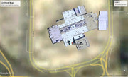
I was looking at aerials in the Westroads Mall area, and noticed that the main building for the mall is the same no matter what date is chosen on historical view. For reference I have added the aerial from 1985.
Why is it like this?
-
BRoss
- IT Director
- Posts: 10003360
- Joined: Fri Aug 04, 2006 7:39 pm
- Location: West Central Omaha
Re: Google Maps & Google Earth
That looks like a 3D model for it. Go to View > Sidebar and then uncheck 3D Buildings.bbinks wrote: Wed Feb 26, 2025 1:02 pm Question on Google Earth aerial view.
I was looking at aerials in the Westroads Mall area, and noticed that the main building for the mall is the same no matter what date is chosen on historical view. For reference I have added the aerial from 1985.
Why is it like this?
-
bbinks
- Parks & Recreation
- Posts: 1542
- Joined: Thu Sep 14, 2006 4:10 pm
Re: Google Maps & Google Earth
3D was checked, but the other adjacent buildings were not showing 3D as well. That's why it stood out to me.BRoss wrote: Wed Feb 26, 2025 1:38 pmThat looks like a 3D model for it. Go to View > Sidebar and then uncheck 3D Buildings.bbinks wrote: Wed Feb 26, 2025 1:02 pm Question on Google Earth aerial view.
I was looking at aerials in the Westroads Mall area, and noticed that the main building for the mall is the same no matter what date is chosen on historical view. For reference I have added the aerial from 1985.
Why is it like this?
-
BRoss
- IT Director
- Posts: 10003360
- Joined: Fri Aug 04, 2006 7:39 pm
- Location: West Central Omaha
Re: Google Maps & Google Earth
I usually leave it off so not too familiar with it, but I think only some buildings have 3D models.bbinks wrote: Thu Feb 27, 2025 7:50 am 3D was checked, but the other adjacent buildings were not showing 3D as well. That's why it stood out to me.