
Planning Board
Posts: 2380
Joined: Fri Jun 01, 2018 8:14 am
Planning Board
I’m targeting somewhere around Columbus probably to start…

Parks & Recreation
Posts: 1214
Joined: Tue May 08, 2007 10:12 pm
Location: Omaha
Parks & Recreation
That seems like a decent spot to go from. The afternoon HRRR runs are hinting that Omaha could potentially be split with the bulk of the initial line going to the North and then Southern line developing into Iowa and Southeast Nebraska after it is through the metro.stormchaser wrote: ↑Sun May 17, 2026 12:32 pm I’m targeting somewhere around Columbus probably to start…
Planning Board
Posts: 2380
Joined: Fri Jun 01, 2018 8:14 am
Planning Board
Yep, we’ll see if that happensMr.Nuke wrote: ↑Sun May 17, 2026 12:48 pmThat seems like a decent spot to go from. The afternoon HRRR runs are hinting that Omaha could potentially be split with the bulk of the initial line going to the North and then Southern line developing into Iowa and Southeast Nebraska after it is through the metro.stormchaser wrote: ↑Sun May 17, 2026 12:32 pm I’m targeting somewhere around Columbus probably to start…
Parks & Recreation
Posts: 1214
Joined: Tue May 08, 2007 10:12 pm
Location: Omaha
Parks & Recreation
Parks & Recreation
Posts: 1573
Joined: Wed Jan 31, 2007 5:58 pm
Parks & Recreation
Is there a specific place to see the HRRR runs? I tried to find it but I’m a dummy.Mr.Nuke wrote: ↑Sun May 17, 2026 12:48 pmThat seems like a decent spot to go from. The afternoon HRRR runs are hinting that Omaha could potentially be split with the bulk of the initial line going to the North and then Southern line developing into Iowa and Southeast Nebraska after it is through the metro.stormchaser wrote: ↑Sun May 17, 2026 12:32 pm I’m targeting somewhere around Columbus probably to start…
Parks & Recreation
Posts: 1214
Joined: Tue May 08, 2007 10:12 pm
Location: Omaha
Parks & Recreation
It is a federally funded weather model. https://rapidrefresh.noaa.gov/hrrr/ or better displayed somewhere like here. https://www.pivotalweather.com/model.php?m=hrrr
It is arguably the best short-range weather model in North America right now, and runs every hour. With that said if you aren't hugely into weather there isn't really a reason to look at it, and even if you do, you need to have an understanding of what you're looking at. It is basically a computer simulation going forward that restarts every single hour, but you need to compare it to previous model runs for itself and other models as well. On Friday night, the HRRR handled part of the system really well and missed another part whereas another model was the complete opposite.
This is a link to as of the time of my post the HRRRs latest thinking about tonight as far as simulated radar https://www.pivotalweather.com/model.ph ... &dpdt=&mc=
Planning Board
Posts: 2380
Joined: Fri Jun 01, 2018 8:14 am
Planning Board
Ended up seeing a couple funnels early on as the storms first fired northwest of Grand Island. Also saw a wedge (from a distance) near Saint Libory, NE (north of Grand Island).
Pretty cool structure and obvious RFD cut with the wedge underneath though hard to see since the contrast was poor from where I was at as I was trying to reposition and things happened to cycle back up as I was doing so.
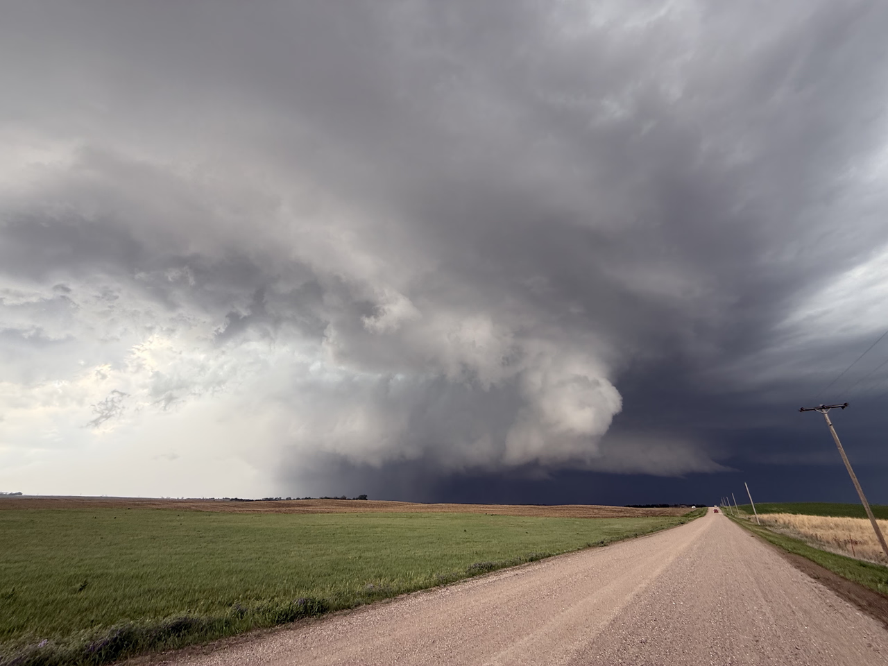
Pretty cool structure and obvious RFD cut with the wedge underneath though hard to see since the contrast was poor from where I was at as I was trying to reposition and things happened to cycle back up as I was doing so.

Photographer
Posts: 1036554
Joined: Sat Feb 28, 2004 6:03 pm
Location: Omaha, NE
Photographer
Nice Photo! You chasing again today?

Omaha Skyline Photos, Omaha Aerial Photos, and More.
Website: www.bradwilliamsphotography.com
Facebook: www.facebook.com/bradwilliamsphotography
Twitter: www.twitter.com/bradwphoto
Instagram: www.instagram.com/bradwilliamsphotography
YouTube: www.youtube.com/@bradwilliamsphoto
City Council
Posts: 106374
Joined: Tue Apr 13, 2004 1:34 pm
Location: Somewhere between downtown and Colorado
City Council
I'm with Brad - great looking shot!
Planning Board
Posts: 2380
Joined: Fri Jun 01, 2018 8:14 am
Planning Board
Thanks!
I'm probably sitting this one out. While I'm sure there will be tornadoes - especially somewhere along the NE/KS border in far southeast NE and/or adjacent parts of northeast KS - my schedule today doesn't work for me to really be out there. Plus I've had my fill the last few days.
Yesterday in particular had TONS of people out to the point of it being more frustrating than anything. It reminded me of what often happens in OK/KS/TX with basically traffic jams out in the middle of "nowhere" and lines of vehicles for as far as you can see (literally hundreds of them). I'm assuming today will be similar in northeast KS/far southeastern NE.
That's why I prefer my sleeper setups TBH .
.
I'm probably sitting this one out. While I'm sure there will be tornadoes - especially somewhere along the NE/KS border in far southeast NE and/or adjacent parts of northeast KS - my schedule today doesn't work for me to really be out there. Plus I've had my fill the last few days.
Yesterday in particular had TONS of people out to the point of it being more frustrating than anything. It reminded me of what often happens in OK/KS/TX with basically traffic jams out in the middle of "nowhere" and lines of vehicles for as far as you can see (literally hundreds of them). I'm assuming today will be similar in northeast KS/far southeastern NE.
That's why I prefer my sleeper setups TBH
. Planning Board
Posts: 2380
Joined: Fri Jun 01, 2018 8:14 am
Planning Board
If anyone is curious, this is what's happening in this photo and is a "real-time" view of what you're seeing when looking at velocities on radar (often the red next to the green used to depict rotation on radar - aka a mesocyclone and sometimes a "radar indicated tornado").
For reference, this is a view of the storm from the south looking north.
Warm/humid inflow feeding into the storm from the east with the "Rear Flank Downdraft" (aka RFD) wrapping around and pushing the opposite direction with cooler/dry air from the west causing rotation. When it has a balance like this and one isn't significantly stronger than the other (aka it doesn't "undercut" the lowering), things tighten up and can produce a tornado.
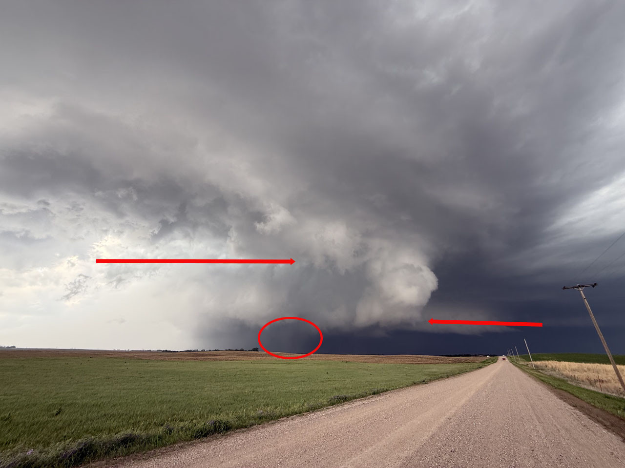
For reference, this is a view of the storm from the south looking north.
Warm/humid inflow feeding into the storm from the east with the "Rear Flank Downdraft" (aka RFD) wrapping around and pushing the opposite direction with cooler/dry air from the west causing rotation. When it has a balance like this and one isn't significantly stronger than the other (aka it doesn't "undercut" the lowering), things tighten up and can produce a tornado.
Last edited by stormchaser on Mon May 18, 2026 11:24 am, edited 5 times in total.
Photographer
Posts: 1036554
Joined: Sat Feb 28, 2004 6:03 pm
Location: Omaha, NE
Photographer
There will be a similar situation when the Union Pacific BigBoy comes through Nebraska next week... LOLstormchaser wrote: ↑Mon May 18, 2026 10:46 am Yesterday in particular had TONS of people out to the point of it being more frustrating than anything. It reminded me of what often happens in OK/KS/TX with basically traffic jams out in the middle of "nowhere" and lines of vehicles for as far as you can see (literally hundreds of them)
Omaha Skyline Photos, Omaha Aerial Photos, and More.
Website: www.bradwilliamsphotography.com
Facebook: www.facebook.com/bradwilliamsphotography
Twitter: www.twitter.com/bradwphoto
Instagram: www.instagram.com/bradwilliamsphotography
YouTube: www.youtube.com/@bradwilliamsphoto
Planning Board
Posts: 2380
Joined: Fri Jun 01, 2018 8:14 am
Planning Board
Lol doesn't surprise meBrad wrote: ↑Mon May 18, 2026 11:07 amThere will be a similar situation when the Union Pacific BigBoy comes through Nebraska next week... LOLstormchaser wrote: ↑Mon May 18, 2026 10:46 am Yesterday in particular had TONS of people out to the point of it being more frustrating than anything. It reminded me of what often happens in OK/KS/TX with basically traffic jams out in the middle of "nowhere" and lines of vehicles for as far as you can see (literally hundreds of them)
Planning Board
Posts: 2380
Joined: Fri Jun 01, 2018 8:14 am
Planning Board
Same tornado I saw just waaayyyy closer.
Photographer
Posts: 1036554
Joined: Sat Feb 28, 2004 6:03 pm
Location: Omaha, NE
Photographer
I hate vertical video so much!
Omaha Skyline Photos, Omaha Aerial Photos, and More.
Website: www.bradwilliamsphotography.com
Facebook: www.facebook.com/bradwilliamsphotography
Twitter: www.twitter.com/bradwphoto
Instagram: www.instagram.com/bradwilliamsphotography
YouTube: www.youtube.com/@bradwilliamsphoto
Planning Board
Posts: 2380
Joined: Fri Jun 01, 2018 8:14 am
Planning Board
City Council
Posts: 106374
Joined: Tue Apr 13, 2004 1:34 pm
Location: Somewhere between downtown and Colorado
City Council
PDS tornado watch issued for far southeast NE, southwest into central KS.

Planning Board
Posts: 2136
Joined: Tue Mar 09, 2004 10:44 pm
Location: Omaha
Planning Board
I'd be surprised if metro Omaha area gets hit again today... it's almost chilly outside compared to the past few days.
Photographer
Posts: 1036554
Joined: Sat Feb 28, 2004 6:03 pm
Location: Omaha, NE
Photographer
The front hasn't moved all day... Its been down by Nebraska City since I woke up today.
You do not have the required permissions to view the files attached to this post.
Omaha Skyline Photos, Omaha Aerial Photos, and More.
Website: www.bradwilliamsphotography.com
Facebook: www.facebook.com/bradwilliamsphotography
Twitter: www.twitter.com/bradwphoto
Instagram: www.instagram.com/bradwilliamsphotography
YouTube: www.youtube.com/@bradwilliamsphoto
Planning Board
Posts: 2380
Joined: Fri Jun 01, 2018 8:14 am
Planning Board
County Board
Posts: 4936
Joined: Fri Dec 23, 2011 4:23 pm
Location: Dundee
County Board
Looking like we are going to get jack squat right now.
Planning Board
Posts: 2380
Joined: Fri Jun 01, 2018 8:14 am
Planning Board

City Council
Posts: 11628
Joined: Mon Feb 09, 2004 11:26 am
Location: Omaha/Bellevue
City Council

City Council
Posts: 7327
Joined: Sat Apr 09, 2011 7:32 pm
Location: North Central Omaha
City Council
This upcoming cool stretch is quite an anomaly. In the 13 years I've been gardening, I cannot recall any year that Ive been concerned about it being too cool this late into May. Although they say not to plant watermelon and such til June, Ive never had a problem squeezing in some extra growing time by planting them right along my other plants after the last freeze. Heck, I was even running a bit late this year by planting everything on the 11th. We'll see how this goes, but I'll be surprised if the watermelon make it through this late cool spell.
I'm a firm believer that earth and the environment is a vessel in that you can't take away or add anything.to it. So for the out of place warm (hot) days in winter and spring, we're paying it back now with an out of place late May cool spell.
And I mean it is CHILLY.
I'm a firm believer that earth and the environment is a vessel in that you can't take away or add anything.to it. So for the out of place warm (hot) days in winter and spring, we're paying it back now with an out of place late May cool spell.
And I mean it is CHILLY.

Library Board
Posts: 260
Joined: Wed Nov 13, 2024 10:38 am
Library Board
I want to try some zucchini this year in the garden. I wonder if I should wait until Saturday for slightly warmer over-nights to transplant it?Busguy2010 wrote: ↑Tue May 19, 2026 1:16 pm In the 13 years I've been gardening, I cannot recall any year that Ive been concerned about it being too cool this late into May.
City Council
Posts: 7327
Joined: Sat Apr 09, 2011 7:32 pm
Location: North Central Omaha
City Council
I'd wait. Since I already planted stuff like that, im just crossing my fingers. But when it comes down to it, even starting in June is just enough time. I won't be surprised if I have to start again from seed. Come to think of it, I may just restart them in some peat pots just for insurance. By the time they come up, the forecast looks plenty warm.remline wrote: ↑Wed May 20, 2026 9:48 amI want to try some zucchini this year in the garden. I wonder if I should wait until Saturday for slightly warmer over-nights to transplant it?Busguy2010 wrote: ↑Tue May 19, 2026 1:16 pm In the 13 years I've been gardening, I cannot recall any year that Ive been concerned about it being too cool this late into May.
Photographer
Posts: 1036554
Joined: Sat Feb 28, 2004 6:03 pm
Location: Omaha, NE
Photographer
My neighborhood near 90th & Center, we received 5.10 in of rain in May. Not bad at all.
Omaha Skyline Photos, Omaha Aerial Photos, and More.
Website: www.bradwilliamsphotography.com
Facebook: www.facebook.com/bradwilliamsphotography
Twitter: www.twitter.com/bradwphoto
Instagram: www.instagram.com/bradwilliamsphotography
YouTube: www.youtube.com/@bradwilliamsphoto
County Board
Posts: 4330
Joined: Fri Oct 19, 2007 9:50 pm
Location: Council Bluffs
County Board

Go Cubs Go
Planning Board
Posts: 2380
Joined: Fri Jun 01, 2018 8:14 am
Planning Board
Just a heads up that overnight tonight into early tomorrow morning looks potentially dangerous in the local area.
Overnight tornado outbreaks are relatively uncommon (where storms develop during the overnight hours I mean - storms lasting into the overnight hours aren't uncommon, however).
What's being depicted on the 12z HRRR for sometime in the 3 AM to 6 AM timeframe overnight tonight/early tomorrow screams potential tornadoes currently.
Hopefully that isn't what ends up happening but heads up to pay attention and be prepared anyway.
Overnight tornado outbreaks are relatively uncommon (where storms develop during the overnight hours I mean - storms lasting into the overnight hours aren't uncommon, however).
What's being depicted on the 12z HRRR for sometime in the 3 AM to 6 AM timeframe overnight tonight/early tomorrow screams potential tornadoes currently.
Hopefully that isn't what ends up happening but heads up to pay attention and be prepared anyway.
Parks & Recreation
Posts: 1214
Joined: Tue May 08, 2007 10:12 pm
Location: Omaha
Parks & Recreation
City Council
Posts: 11628
Joined: Mon Feb 09, 2004 11:26 am
Location: Omaha/Bellevue
City Council
Glad that the metro was mostly spared this morning from the storms and the rain was a nice benefit.
Photographer
Posts: 1036554
Joined: Sat Feb 28, 2004 6:03 pm
Location: Omaha, NE
Photographer
Yeah, we got 0.82" and didn't have anything bad this time! I see Rusty posted about 2 tornadoes in Cass and Mills county this morning.skinzfan23 wrote: ↑Thu Jun 11, 2026 10:39 am Glad that the metro was mostly spared this morning from the storms and the rain was a nice benefit.
Omaha Skyline Photos, Omaha Aerial Photos, and More.
Website: www.bradwilliamsphotography.com
Facebook: www.facebook.com/bradwilliamsphotography
Twitter: www.twitter.com/bradwphoto
Instagram: www.instagram.com/bradwilliamsphotography
YouTube: www.youtube.com/@bradwilliamsphoto
City Council
Posts: 11628
Joined: Mon Feb 09, 2004 11:26 am
Location: Omaha/Bellevue
City Council
Yeah, living near the Platte River I was a little worried for a while, but they went straight east instead of NE.
I got 1.65" in Bellevue, I am sure most of the metro got less but 8/10" is still great.
I got 1.65" in Bellevue, I am sure most of the metro got less but 8/10" is still great.
Parks & Recreation
Posts: 1229
Joined: Thu Feb 04, 2016 8:16 pm
Location: Omaha
Parks & Recreation
I went and hung out on the 6th floor of the north parking garage so my car would be protected. Stood and watched the storm roll in. At a couple times, the rain was so heavy I couldn’t see the lights and signs on the skyscrapers.
Brad, if you haven’t taken photos from there, it’s an excellent vantage point!
Photographer
Posts: 1036554
Joined: Sat Feb 28, 2004 6:03 pm
Location: Omaha, NE
Photographer
Which parking Garage?GenX wrote: ↑Fri Jun 12, 2026 2:06 am I went and hung out on the 6th floor of the north parking garage so my car would be protected. Stood and watched the storm roll in. At a couple times, the rain was so heavy I couldn’t see the lights and signs on the skyscrapers.
Brad, if you haven’t taken photos from there, it’s an excellent vantage point!
Omaha Skyline Photos, Omaha Aerial Photos, and More.
Website: www.bradwilliamsphotography.com
Facebook: www.facebook.com/bradwilliamsphotography
Twitter: www.twitter.com/bradwphoto
Instagram: www.instagram.com/bradwilliamsphotography
YouTube: www.youtube.com/@bradwilliamsphoto
Planning Board
Posts: 2330
Joined: Thu Nov 29, 2018 1:02 pm
Planning Board
Pretty big thunderstorm this morning. Not sure how much rain, thinking definitely over an inch and some wind gust of around 50-60 mph. Glad it wasn’t any worse with the CWS just starting.
County Board
Posts: 4936
Joined: Fri Dec 23, 2011 4:23 pm
Location: Dundee
County Board
Human Relations
Posts: 925
Joined: Thu Jul 27, 2017 9:53 pm
Location: Omaha
Parks & Recreation
Posts: 1229
Joined: Thu Feb 04, 2016 8:16 pm
Location: Omaha
Parks & Recreation
NorthBrad wrote: ↑Fri Jun 12, 2026 8:06 amWhich parking Garage?GenX wrote: ↑Fri Jun 12, 2026 2:06 am I went and hung out on the 6th floor of the north parking garage so my car would be protected. Stood and watched the storm roll in. At a couple times, the rain was so heavy I couldn’t see the lights and signs on the skyscrapers.
Brad, if you haven’t taken photos from there, it’s an excellent vantage point!
Photographer
Posts: 1036554
Joined: Sat Feb 28, 2004 6:03 pm
Location: Omaha, NE
Photographer
At the airport? That's the only garage I have heard to referred to as "North", but that seems like a really expensive place to ride out a storm compared to the garages downtown.GenX wrote: ↑Sat Jun 13, 2026 3:25 pmNorthBrad wrote: ↑Fri Jun 12, 2026 8:06 amWhich parking Garage?GenX wrote: ↑Fri Jun 12, 2026 2:06 am I went and hung out on the 6th floor of the north parking garage so my car would be protected. Stood and watched the storm roll in. At a couple times, the rain was so heavy I couldn’t see the lights and signs on the skyscrapers.
Brad, if you haven’t taken photos from there, it’s an excellent vantage point!
Omaha Skyline Photos, Omaha Aerial Photos, and More.
Website: www.bradwilliamsphotography.com
Facebook: www.facebook.com/bradwilliamsphotography
Twitter: www.twitter.com/bradwphoto
Instagram: www.instagram.com/bradwilliamsphotography
YouTube: www.youtube.com/@bradwilliamsphoto