nebport5 wrote: Tue Apr 02, 2024 9:36 pm
Dusty wrote: Tue Apr 02, 2024 4:41 pm
The projects chosen were based on the criteria laid out in the Notice of Funding Opportunity; this marked the second time applicants were asked to prioritize TOD in areas with high rates of homelessness.
This is a terrible choice for an extension. The selection of the route was based on level of homelessness and not what makes sense for our transit network. Once, you pass Creighton it's single-family homes all the way to Ames. Are they planning on bulldozing all these homes to build density? What I see is North Omaha residents displaced through gentrification.
We don't need this. It's the wrong mode. Buses would do a lot better job on moving people through this area.
I have said before...the streetcar is not a silver bullet. Outside of Farnam, I would do the 10th Street extension and that's it. I would much rather see a commuter rail to Lincoln than any streetcar extension zig zagging all over with no rhyme or reason.
Keep in mind 19th terminates just after Lake St. The route would likely veer east to 16th or possibly West to 20th or 24th St. The route could start from 19th yet deviate east or west well before Lake and there is your study.
I suspect this is the route(rather than Abbott) that the mayor is referring to when stating eventually the streetcar will go all the way to the airport. This is also in line with Senator Wayne's proposal. Given the parties expressing support for this route I imagine affordable housing would also be key component to city/state initiated TOD.
We really have no idea what this extension looks like. While a 3 mile extension could just go north to Ames, I also measured about 3 miles to go north 19th/Florence, turn right at Locust and get to the south side of the big proposed North Omaha industrial site at 14th Ave. Alternatively, you can draw out a 3 mile extension by going north on 19th, turning right on Cuming, then right on 10th to reconnect with the initial route at Capitol. That likely is not the route, otherwise they would call it a loop, but we all don't know at this point.
At the very least, this prospective 19th street extension of the streetcar excites me because of this area:
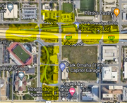
I marked in yellow the city blocks (9 of them) that were identified as future development opportunities according to the urban core strategic plan, if we could get rid of the I-480 overpass/20th street exit. When we heard about Senator Wayne pushing for a North Omaha extension at the state level, we were all thinking 16th. I think if you consider what I highlighted in yellow, the 19th street extension, makes some sense. Imagining at stop at Cass street, you I capture three blocks east and west. Going west, that just happened to be the 3 block limit of the existing streetcar TIF district. Note that currently, the Civic Site is just outside that district; running up 19th would capture that project.
Maybe 19th street is being done to help spur the discussions of taking down I-480 and this offramp. Just rough calculations, based on 37 West, the 9 story apartment/garage in Blackstone, that project is worth about $40 million. That's a half a city block and has a parking to apartment unit ratio of 400:160 because it also serves as the garage for Blackstone. Imagine each of those highlighted city blocks with even denser development. Even if you conservatively estimated added 300 units per city block, you're looking at least $700 million in new development. Noddle's 4 story speculative office building was $57 million and that has a foot print of about half a city block as well. Maybe Creighton wants more space to expand their campus; they take two blocks between 22nd and 20th. Their recent health sciences building cost $75 million.
I would be even more optimistic that each block could bring at least $100 million each block, meaning nearly $1 billion. That doesn't include what this could do for the Civic Site, ie. lead to even more density.
Again rough numbers and the demolition of I-480 is still far out there (though we are probably at or past usable life of the overpass; I don't know exactly when the overpass was completed, but seems like early 1970's). What do you think?