POTUS
Home Owners Association
Posts: 119
Joined: Mon Nov 08, 2004 12:25 am
Location: UNL
POTUS
Home Owners Association
1. Downtown in general
2. The airport
3. Lake Manawa exit, Council Bluffs (look, an eyesore!)
4. Just a country mile north in Blair, Nebraska!

I have already started to use google maps in my urban planning. The west side of the city doesn't have great satellite images, but they will work. I am not concerned though, because there is little urban planning to do there, all the good stuff is east of 72nd Street.

Image
Image
Image
Image
projectman
Human Relations
Posts: 867
Joined: Thu Sep 02, 2004 2:44 am
Location: Millard/Sarpy County
projectman
Human Relations
I love these satellite pictures. Eppley looks pretty abandoned though. A whole 3 planes.
POTUS
Home Owners Association
Posts: 119
Joined: Mon Nov 08, 2004 12:25 am
Location: UNL
POTUS
Home Owners Association
Okay, so I had nothing else to do today.

Below are pictures of:
1. Aircraft carrier at NAS Coronado (where I spent my last 6 months in the Navy.)
2. The Hoover Dam
3. Memorial Stadium, Lincoln
4. The Pentagon (in case you couldn't tell)
5. The Space Needle and Experience Music Project
6. The Statue of Liberty (again, in case you couldn't tell)
7. Worlds of Fun, Kansas City
8. World Trade Center site, after

Image
Image
Image
Image
Image
Image
Image
Image
User avatar
Swift
Planning Board
Posts: 2887
Joined: Thu Oct 28, 2004 7:13 pm
Location: NYC
User avatar
Swift
Planning Board
yeah google maps is awesome.
POTUS
Home Owners Association
Posts: 119
Joined: Mon Nov 08, 2004 12:25 am
Location: UNL
POTUS
Home Owners Association
Anyone know what this is? I do. This kind of stuff makes me proud to be American.

Image
lpgforms
Home Owners Association
Posts: 60
Joined: Thu Apr 14, 2005 6:24 pm
lpgforms
Home Owners Association
I live down in Bellevue, and my former neighbor Chris, who was the store manager at the WalMart in Council Bluffs until last year, coordinated and did most of the work plowing that farmer's field each fall since 2001. It would take him about 10 days to do each message

It was in the flght path to Offut along 75. Chris told me that that President Bush was impressed with his efforts after seeing it, and the prez has a picture of it in his office.

Sadly, Chris moved on to a new SuperWalmart in Southwest Missouri last August. There was no message for our airmen this year.

But it's real cool that the Google images has a photo of it! I'll have to send it to him
User avatar
TitosBuritoBarn
Planning Board
Posts: 3281
Joined: Tue Nov 09, 2004 1:08 am
Location: St. Louis
User avatar
TitosBuritoBarn
Planning Board
I like how its spring time over a fourth of Worlds of Fun and winter in the other 3/4ths.
User avatar
Brad
Photographer
Posts: 1036642
Joined: Sun Feb 29, 2004 12:03 am
Location: Omaha, NE
User avatar
Brad
Photographer
This is dangerous. I can see myself on it for hours.

Zephyr, there is a lot of information on this for your railroad project!!!
almighty_tuna
City Council
Posts: 106398
Joined: Tue Apr 13, 2004 6:34 pm
Location: Somewhere between downtown and Colorado
almighty_tuna
City Council
No kidding. I spent an embarassing amount of time searching airports across the country to find airplanes which just took off. Incidentally I found an accident on a DFW freeway.
User avatar
zedmib
Home Owners Association
Posts: 129
Joined: Tue Feb 10, 2004 1:50 pm
User avatar
zedmib
Home Owners Association
I too have spent time looking at the satellite photos. If you go to Alliance airport north of Fort Worth there is an AN-124 parked on the east ramp.
To Growth! When do we get a Supertall! :mrgreen:
Zed
almighty_tuna
City Council
Posts: 106398
Joined: Tue Apr 13, 2004 6:34 pm
Location: Somewhere between downtown and Colorado
almighty_tuna
City Council
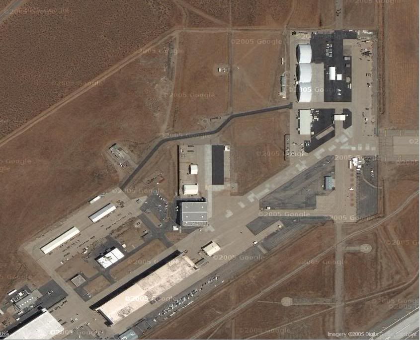
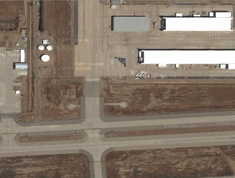
My finds of the night are a stealth fighter and flying wing at a base between Lancaster and Palmdale, CA.

Image
Image
OmahaDevelopmentMan
Human Relations
Posts: 593
Joined: Wed Nov 10, 2004 12:12 am
Location: Omaha, someplace in middle America
OmahaDevelopmentMan
Human Relations
Is area 51 blocked off on this, my trial ended two days ago.
User avatar
TitosBuritoBarn
Planning Board
Posts: 3281
Joined: Tue Nov 09, 2004 1:08 am
Location: St. Louis
User avatar
TitosBuritoBarn
Planning Board
Yes it is.

If you go to DC, you'll notice the Capital building has been blurred out too.
POTUS
Home Owners Association
Posts: 119
Joined: Mon Nov 08, 2004 12:25 am
Location: UNL
POTUS
Home Owners Association
What a wonderful web we weave.

We spend so much effort trying to free ourselves from... ourselves. A minority rises up against a majority. One person takes a stand. Laws are passed, people are murdered, headlines are made. On one hand we create things like the First Admendment, and to lesser degrees the Freedom of Information Act. In the other hand the censorship, confidentiality, classification, and coverups. Just what are we fighting for here? Ultimate freedom or ultimate security. Humans individually may not be suicidal, but as a species we sure are.

Why do I even spout all this? Because Google has taken the time to blur out Area 51 and the Capitol building. Shining examples of two places created to maintain our freedom blurred by some unidentified government hand (or perhaps so ingrained into our society, Google censored the aerials themselves). I say let the people see the satellite images of the Capitol Building and Area 51, so that they fear the real enemies, and not the supposed protectors that reside within.

Or something like that.
MTO
City Council
Posts: 7783
Joined: Wed Mar 09, 2005 5:49 pm
Location: Dundee
MTO
City Council
I like how its spring time over a fourth of Worlds of Fun and winter in the other 3/4ths.
On that same note, it is the same way in Omaha at about 43½ St.
15-17, 26, 32
almighty_tuna
City Council
Posts: 106398
Joined: Tue Apr 13, 2004 6:34 pm
Location: Somewhere between downtown and Colorado
almighty_tuna
City Council
That I can't answer, but if you go to Phoenix and look at Sky Harbor, then scroll east along the canal you will come to where they spliced images together.
Mike
New to the Neighborhood
Posts: 7
Joined: Mon Mar 21, 2005 4:00 pm
Mike
New to the Neighborhood
OmahaDevelopmentMan wrote:Is area 51 blocked off on this, my trial ended two days ago.
Check this out, pretty interesting stuff.

http://www.livejournal.com/community/th ... 37956.html
POTUS
Home Owners Association
Posts: 119
Joined: Mon Nov 08, 2004 12:25 am
Location: UNL
POTUS
Home Owners Association
And now, some images from Google Earth.

Image where to get coffee when downtown
Image view of 72nd and Dodge
Image Rosenblatt and the Zoo
KCPowercat
Home Owners Association
Posts: 72
Joined: Mon Oct 04, 2004 5:33 pm
KCPowercat
Home Owners Association
tuna....that's so weird, I thought the bomber was only based at Whitman AFB in Knob Noster but that 2nd shot clearly shows one in CA???
eomaha
County Board
Posts: 4176
Joined: Thu Nov 13, 2003 4:29 pm
Location: West Omaha
eomaha
County Board
Probably just luck... at different times of the year you'll even find a B-2 on the tarmac at Offutt.
almighty_tuna
City Council
Posts: 106398
Joined: Tue Apr 13, 2004 6:34 pm
Location: Somewhere between downtown and Colorado
almighty_tuna
City Council
Yeah, I think they are at Whitman, but while trolling around for interesting things I thought I'd check out CA. My in-laws used to live in Lancaster and when we visited them we saw pleeeennnty of "WOW is THAT plane" goin on. So I thought there's definitely going to be some brew ha ha sitting at the base.
User avatar
Swift
Planning Board
Posts: 2887
Joined: Thu Oct 28, 2004 7:13 pm
Location: NYC
User avatar
Swift
Planning Board
I remember one time in highschool, afterschool during track practice, all the sudden this stealth bomber appears in the sky. It was just meandering along, slow as heck. It was really eerie.
DTO Luv
City Council
Posts: 9644
Joined: Sun Jun 06, 2004 9:22 pm
DTO Luv
City Council
My grandpa saw a stealth bomber one time. He lives out int the middle of Nebraska (or nowhere) and he was out one night doing something with the horses and he heard this weird hum and he looked up and se said the bomber wasn't more the a hundred feet up and it was just creeping along. I guess the pilot thought it would be funny to spook some rancher.
DTO
POTUS
Home Owners Association
Posts: 119
Joined: Mon Nov 08, 2004 12:25 am
Location: UNL
POTUS
Home Owners Association
The wonderful world that is Google Maps has added a new feature called Hybrid. It takes the sattelite imagery and overlays a street map. Have look see for yourself.

Image
User avatar
Brad
Photographer
Posts: 1036642
Joined: Sun Feb 29, 2004 12:03 am
Location: Omaha, NE
User avatar
Brad
Photographer
I have seen a B-2 flying around Omaha a Few times, Usually once or twice a year, I also say a pair of B1B's flying around the Cox Classic two years ago.

Nothing beats the LOW flyover of the B2 during the national anthem at the NASCAR race at the Kansas Speedway in Kansas City Kansas. The "Protect One 400" august 2003!
User avatar
Asten
Human Relations
Posts: 689
Joined: Thu Dec 09, 2004 2:25 pm
Yahoo Messenger: [email protected]
Location: Physically: Chicagoland. Historically: Omaha
User avatar
Asten
Human Relations
Brad wrote:I have seen a B-2 flying around Omaha a Few times, Usually once or twice a year, I also say a pair of B1B's flying around the Cox Classic two years ago.

Nothing beats the LOW flyover of the B2 during the national anthem at the NASCAR race at the Kansas Speedway in Kansas City Kansas. The "Protect One 400" august 2003!
The downside is all the NASCAR |expletive| all around <grin>

I'll stick to airshow flyovers, myself. :)
MTO
City Council
Posts: 7783
Joined: Wed Mar 09, 2005 5:49 pm
Location: Dundee
MTO
City Council
Hey all check out Virtual Earth @ http://virtualearth.msn.com/. The images are older than Google’s but you can zoom closer “especially in west Omaha.
15-17, 26, 32
User avatar
Linkin5
County Board
Posts: 4896
Joined: Wed Feb 11, 2004 1:59 am
User avatar
Linkin5
County Board
wow that zooms in really close!
loyalomahan
Library Board
Posts: 426
Joined: Wed Apr 06, 2005 2:37 pm
loyalomahan
Library Board
Anyone notice something else nice about Microsoft's initial virtual Earth map? :D
omahapropertymanager
Home Owners Association
Posts: 224
Joined: Tue May 03, 2005 9:24 pm
Location: Midtown Omaha
omahapropertymanager
Home Owners Association
loyalomahan wrote:Anyone notice something else nice about Microsoft's initial virtual Earth map? :D
That the maps are very outdated?
User avatar
Uffda
County Board
Posts: 4622
Joined: Mon Jun 13, 2005 2:52 am
Location: Land o Lakes, FL
User avatar
Uffda
County Board
Internet sleuths discovered that anyone using Microsoft's new "Virtual Earth" Web site for a bird's-eye view of Apple's corporate headquarters saw only a grainy overhead photograph of a single warehouse and a deserted parking lot.

Apple's sprawling campus and eleven modern buildings -- nowhere to be seen.
http://www.cnn.com/2005/TECH/internet/0 ... index.html
POTUS
Home Owners Association
Posts: 119
Joined: Mon Nov 08, 2004 12:25 am
Location: UNL
POTUS
Home Owners Association
I noticed that Omaha got a dot on the initial image when you start that map service.

All the parks, cemetaries, and golf courses are colored green. The roads are colored too. And the big items like MAC are labeled.

Nonetheless, I use Google Earth now.
loyalomahan
Library Board
Posts: 426
Joined: Wed Apr 06, 2005 2:37 pm
loyalomahan
Library Board
Anyone notice something else nice about Microsoft's initial virtual Earth map?
Omaha is prominently displayed smack dab in the middle of the screen... absent is KC (no space left in Missouri with St Louis) and Denver. This is great -international- exposure. Can you imagine how many people are seeing Omaha pop-up in the center of their screen and saying to themselves... "Omaha". I think that's pretty cool.
omahapropertymanager
Home Owners Association
Posts: 224
Joined: Tue May 03, 2005 9:24 pm
Location: Midtown Omaha
omahapropertymanager
Home Owners Association
Any guesses on how old the maps are on the Microsoft site? I noticed the Qwest center building is not there, neither is the FNB Building. I also looked for Ironhorse Golf Course wasn't there either which would mean that the pics are from at least 1999 because my friends and I used to camp there in high school before the golf course came.
User avatar
Brad
Photographer
Posts: 1036642
Joined: Sun Feb 29, 2004 12:03 am
Location: Omaha, NE
User avatar
Brad
Photographer
omahapropertymanager,

You know you can get the best maps right at you work! :wink:
omahapropertymanager
Home Owners Association
Posts: 224
Joined: Tue May 03, 2005 9:24 pm
Location: Midtown Omaha
omahapropertymanager
Home Owners Association
Brad wrote:omahapropertymanager,

You know you can get the best maps right at you work! :wink:
That is true! I haven't had a chance to mess with them yet, but I'm sure I will!
POTUS
Home Owners Association
Posts: 119
Joined: Mon Nov 08, 2004 12:25 am
Location: UNL
POTUS
Home Owners Association
This is the town where I lived in Germany from 1988-1991. It's called Sulzbach, and it's about 100 miles east of Frankfurt.

Google Earth: Rehashing Memories Via The Geek In All Of Us.

Image
POTUS
Home Owners Association
Posts: 119
Joined: Mon Nov 08, 2004 12:25 am
Location: UNL
POTUS
Home Owners Association
This is an image of the Platte River west of Valley, NE. In the middle of the Platte is an island. That island has a lake. Ha! Only in Nebraska.

Image
POTUS
Home Owners Association
Posts: 119
Joined: Mon Nov 08, 2004 12:25 am
Location: UNL
POTUS
Home Owners Association
I was surfing around Omaha with Google Earth today when I noticed they had updated some areas of the metro. I don't know when they did this, but my guess is the images are from early 2005. The Qwest and UPC are done (as seen in the picture) but SoMa has only a few foundations poured and one building up.

Anyways, nice of Google to update the Big O.

Image
User avatar
TitosBuritoBarn
Planning Board
Posts: 3281
Joined: Tue Nov 09, 2004 1:08 am
Location: St. Louis
User avatar
TitosBuritoBarn
Planning Board
They finally have an image above my home in the Zorinsky Lake Vicinity as well.