My dad says it was asphalt, but he think it was concrete before that, but he is not sure.
I have never ate at Pop -n- Docs. So I don't know how good that food is. I know they had a hard time getting back going after the flooding.
Missouri River
Moderators: nebugeater, Omaha Cowboy, Brad, BRoss
-
advcomp2019
- Home Owners Association
- Posts: 126
- Joined: Fri Oct 12, 2012 6:23 pm
- Location: Omaha Metro Area
-
advcomp2019
- Home Owners Association
- Posts: 126
- Joined: Fri Oct 12, 2012 6:23 pm
- Location: Omaha Metro Area
Missouri River
Here is some news. It was in the local paper and I could not find it online yet.
The Decatur-Onawa bridge is going to be free as of December 1st. The states will have control of it on December 4th.
The Decatur-Onawa bridge is going to be free as of December 1st. The states will have control of it on December 4th.
-
Coyote

- City Council
- Posts: 34366
- Joined: Tue Nov 18, 2003 11:18 am
- Location: Aksarben Village
Missouri River
I also read that somewhere recently.
-
Coyote
- City Council
- Posts: 34366
- Joined: Tue Nov 18, 2003 11:18 am
- Location: Aksarben Village
Re: Missouri River
A quick video I took from this morning:
[BBvideo 560,340]http://youtube.com/watch&v?eGkBt3M3X3w[/BBvideo]
[BBvideo 560,340]http://youtube.com/watch&v?eGkBt3M3X3w[/BBvideo]
-
Coyote
- City Council
- Posts: 34366
- Joined: Tue Nov 18, 2003 11:18 am
- Location: Aksarben Village
Re: Missouri River
A quick video I took from this morning:
[BBvideo 560,340]http://youtube.com/watch&v?tkyc9MTUGQk[/BBvideo]
[BBvideo 560,340]http://youtube.com/watch&v?tkyc9MTUGQk[/BBvideo]
-
almighty_tuna
- City Council
- Posts: 106344
- Joined: Tue Apr 13, 2004 1:34 pm
- Location: Somewhere between downtown and Colorado
Re: Missouri River
Ice floes are fantastic, especially at night. The sound is pretty cool, too.
-
Coyote
- City Council
- Posts: 34366
- Joined: Tue Nov 18, 2003 11:18 am
- Location: Aksarben Village
Re: Missouri River
Yeah, the sound of the ice patches hitting each other and the shore are cool.
[BBvideo 560,340]http://youtube.com/watch&v?Y4U1_yRZpAY[/BBvideo]
[BBvideo 560,340]http://youtube.com/watch&v?Y4U1_yRZpAY[/BBvideo]
-
Coyote
- City Council
- Posts: 34366
- Joined: Tue Nov 18, 2003 11:18 am
- Location: Aksarben Village
-
thenewguy

- County Board
- Posts: 4275
- Joined: Fri Oct 19, 2007 9:50 pm
- Location: Council Bluffs
Re: Missouri River
It's crazy how low the river is right now. I never noticed before but it is below the inlets for the boat dock by Rick's.
Go Cubs Go
-
almighty_tuna
- City Council
- Posts: 106344
- Joined: Tue Apr 13, 2004 1:34 pm
- Location: Somewhere between downtown and Colorado
Re: Missouri River
I believe that is an annual occurrence. The Army Corps drop the river level in the winter to mimic the natural, seasonal ebb and flow.
-
Brad

- Photographer
- Posts: 1036433
- Joined: Sat Feb 28, 2004 6:03 pm
- Location: Omaha, NE
Re: Missouri River
The ice is always cool! Been plenty of it this year.

Omaha Skyline Photos, Omaha Aerial Photos, and More.
Website: www.bradwilliamsphotography.com
Facebook: www.facebook.com/bradwilliamsphotography
Twitter: www.twitter.com/bradwphoto
Instagram: www.instagram.com/bradwilliamsphotography
YouTube: www.youtube.com/@bradwilliamsphoto
-
Coyote
- City Council
- Posts: 34366
- Joined: Tue Nov 18, 2003 11:18 am
- Location: Aksarben Village
Re: Missouri River
But, the question begs itself, is there enough light to capture a good vid/pic at the witching hour?almighty_tuna wrote:Ice floes are fantastic, especially at night.
-
almighty_tuna
- City Council
- Posts: 106344
- Joined: Tue Apr 13, 2004 1:34 pm
- Location: Somewhere between downtown and Colorado
Re: Missouri River
I will have to bring my camera to find out. I've never shot the ice floes at night along the river.Coyote wrote:But, the question begs itself, is there enough light to capture a good vid/pic at the witching hour?almighty_tuna wrote:Ice floes are fantastic, especially at night.
-
Brad
- Photographer
- Posts: 1036433
- Joined: Sat Feb 28, 2004 6:03 pm
- Location: Omaha, NE
Re: Missouri River
There is a lot of Water heading our way
http://www.water.weather.gov/ahps2/hydr ... gage=omhn1" onclick="window.open(this.href);return false;
Current Forecast is for a crest at 30.4'. For comparison, 2011 was 36.29'.
Until Sunday, the river had been running about 16'.
http://www.water.weather.gov/ahps2/hydr ... gage=omhn1" onclick="window.open(this.href);return false;
Current Forecast is for a crest at 30.4'. For comparison, 2011 was 36.29'.
Until Sunday, the river had been running about 16'.
Omaha Skyline Photos, Omaha Aerial Photos, and More.
Website: www.bradwilliamsphotography.com
Facebook: www.facebook.com/bradwilliamsphotography
Twitter: www.twitter.com/bradwphoto
Instagram: www.instagram.com/bradwilliamsphotography
YouTube: www.youtube.com/@bradwilliamsphoto
-
Tornado
- Home Owners Association
- Posts: 189
- Joined: Sun Aug 17, 2008 10:52 am
- Location: West Omaha
Re: Missouri River
The Platte and Elkhorn are also very high, although the Elkhorn is dropping.
-
iamjacobm

- City Council
- Posts: 10796
- Joined: Sat Apr 10, 2010 6:52 am
- Location: Chicago
Re: Missouri River
The water is really really high already. Anyway to check the current levels vs. the expect levels?
Edit: Duh on the chart posted by Brad
Edit: Duh on the chart posted by Brad
-
skinzfan23

- City Council
- Posts: 11569
- Joined: Mon Feb 09, 2004 11:26 am
- Location: Omaha/Bellevue
Re: Missouri River
Looks like the forecast would put the river levels above what they were in 1993.Brad wrote:There is a lot of Water heading our way
http://www.water.weather.gov/ahps2/hydr ... gage=omhn1" onclick="window.open(this.href);return false;
Current Forecast is for a crest at 30.4'. For comparison, 2011 was 36.29'.
Until Sunday, the river had been running about 16'.
-
Uffda

- County Board
- Posts: 4616
- Joined: Sun Jun 12, 2005 9:52 pm
- Location: Land o Lakes, FL
Re: Missouri River
The Sioux Falls area has had 13" of rain since the the first of June. Most of that flows into the Big Sioux River which enters the Missouri at Sioux City. The day of the tornados in Pilger, the city of Canton had 8" of rain that is all coming down the Big Sioux. The area had so much rain/water the other day that I-29 was closed in several spot as water was flowing over it.
http://www.argusleader.com/story/news/2 ... /10695969/" onclick="window.open(this.href);return false;
Found these taken by a company with a small remote helicopter
https://www.facebook.com/media/set/?set ... 830&type=1" onclick="window.open(this.href);return false;
http://www.argusleader.com/story/news/2 ... /10695969/" onclick="window.open(this.href);return false;
Found these taken by a company with a small remote helicopter
https://www.facebook.com/media/set/?set ... 830&type=1" onclick="window.open(this.href);return false;
-
Tornado
- Home Owners Association
- Posts: 189
- Joined: Sun Aug 17, 2008 10:52 am
- Location: West Omaha
Re: Missouri River
32 ft crest now forecast
-
GetUrban
- Planning Board
- Posts: 2647
- Joined: Sun Nov 23, 2008 3:07 pm
- Location: Omaha
Re: Missouri River
Looks like they've had a lot of rain in the northern part of the Missouri River basin too. Hopefully the reservoirs will continue to have enough capacity this time. If not, it could be another repeat of 2011.
http://www.crh.noaa.gov/mbrfc/
http://www.nwd-mr.usace.army.mil/rcc/re ... _Daily.pdf
Dam release info
http://www.crh.noaa.gov/mbrfc/
http://www.nwd-mr.usace.army.mil/rcc/re ... _Daily.pdf
Dam release info
Last edited by GetUrban on Wed Jun 18, 2014 12:58 pm, edited 1 time in total.
He said "They are some big, ugly red brick buildings"
...and then they were gone.
...and then they were gone.
-
Coyote
- City Council
- Posts: 34366
- Joined: Tue Nov 18, 2003 11:18 am
- Location: Aksarben Village
Re: Missouri River
I wish I would have posted the article from a month ago or so, but someone reported on snow melt and reservoir capacity and made it sound like they were all under control. But you never know...
-
Brad
- Photographer
- Posts: 1036433
- Joined: Sat Feb 28, 2004 6:03 pm
- Location: Omaha, NE
Re: Missouri River
Have they installed the flood gates down by Storz yet?
Omaha Skyline Photos, Omaha Aerial Photos, and More.
Website: www.bradwilliamsphotography.com
Facebook: www.facebook.com/bradwilliamsphotography
Twitter: www.twitter.com/bradwphoto
Instagram: www.instagram.com/bradwilliamsphotography
YouTube: www.youtube.com/@bradwilliamsphoto
-
Linkin5

- County Board
- Posts: 4863
- Joined: Tue Feb 10, 2004 7:59 pm
Re: Missouri River
How is Playland Park going to do with this?
-
skinzfan23
- City Council
- Posts: 11569
- Joined: Mon Feb 09, 2004 11:26 am
- Location: Omaha/Bellevue
Re: Missouri River
Thats what I was wondering.Linkin5 wrote:How is Playland Park going to do with this?
This is from the weather channel's website:
" AT 3:00 PM TUESDAY THE STAGE WAS 20.8 FEET. * FLOOD STAGE IS 29.0 FEET. * FORECAST... THE RIVER MAY RISE TO NEAR 30.9 FEET MONDAY MORNING. * IMPACT... AT 32.0 FEET... INTERSTATE 680 WEST BETWEEN THE MORMON BRIDGE AND INTERSTATE 29 BEGINS TO FLOOD. ALSO... INTERSTATE 29 BETWEEN CRESCENT AND COUNCIL BLUFFS BEGINS TO FLOOD. * IMPACT... AT 29.0 FEET... SIGNIFICANT LOWLAND FLOODING OCCURS IN NP DODGE PARK... FREEDOM PARK... PLAYLAND PARK... FONTENELLE FOREST AND HAWORTH PARK. * IMPACT... AT 27.0 FEET... NP DODGE PARK... FREEDOM PARK... PLAYLAND PARK AND FONTENELLE FOREST BEGIN TO FLOOD. * IMPACT... AT 25.0 FEET... A CASINO PARKING LOT BEGINS TO FLOOD ALONG THE IOWA SIDE OF THE RIVER. IN ADDITION, HAWORTH PARK LOCATED IN BELLEVUE BEGINS TO FLOOD. "
-
GetUrban
- Planning Board
- Posts: 2647
- Joined: Sun Nov 23, 2008 3:07 pm
- Location: Omaha
Re: Missouri River
Not sure what the exact boundaries are for Playland Park in C.B, but I thought it was on the "dry" side of the levy. The new River's Edge park is on the wet side. It will be sad to see that flood so soon after it opened. Comes with the territory though.....
The duration of this flood shouldn't be anything like 2011, I'd guess.
The duration of this flood shouldn't be anything like 2011, I'd guess.
He said "They are some big, ugly red brick buildings"
...and then they were gone.
...and then they were gone.
-
Brad
- Photographer
- Posts: 1036433
- Joined: Sat Feb 28, 2004 6:03 pm
- Location: Omaha, NE
Re: Missouri River
That's not good!
Omaha Skyline Photos, Omaha Aerial Photos, and More.
Website: www.bradwilliamsphotography.com
Facebook: www.facebook.com/bradwilliamsphotography
Twitter: www.twitter.com/bradwphoto
Instagram: www.instagram.com/bradwilliamsphotography
YouTube: www.youtube.com/@bradwilliamsphoto
-
Coyote
- City Council
- Posts: 34366
- Joined: Tue Nov 18, 2003 11:18 am
- Location: Aksarben Village
Re: Missouri River
I would have to believe that us a mistake; by Playland they really mean Hanafan's Rivers Edge?
-
skinzfan23
- City Council
- Posts: 11569
- Joined: Mon Feb 09, 2004 11:26 am
- Location: Omaha/Bellevue
Re: Missouri River
Thats true, that is what was so hard in 2011. The flood lasted weeks and put pressure on the levies and obviously killed many trees and plants. It sounds like this would subside rather quickly and hopefully not do a lot of damage. I sure hope it doesn't kill the new trees they just planted.GetUrban wrote:Not sure what the exact boundaries are for Playland Park in C.B, but I thought it was on the "dry" side of the levy. The new River's Edge park is on the wet side. It will be sad to see that flood so soon after it opened. Comes with the territory though.....
The duration of this flood shouldn't be anything like 2011, I'd guess.
-
Brad
- Photographer
- Posts: 1036433
- Joined: Sat Feb 28, 2004 6:03 pm
- Location: Omaha, NE
Re: Missouri River
It will still cover everything in mud!
Omaha Skyline Photos, Omaha Aerial Photos, and More.
Website: www.bradwilliamsphotography.com
Facebook: www.facebook.com/bradwilliamsphotography
Twitter: www.twitter.com/bradwphoto
Instagram: www.instagram.com/bradwilliamsphotography
YouTube: www.youtube.com/@bradwilliamsphoto
-
Coyote
- City Council
- Posts: 34366
- Joined: Tue Nov 18, 2003 11:18 am
- Location: Aksarben Village
Re: Missouri River
Did they have a game plan to deal with this? You would have to think they would try to at least cosmetically clean it up as soon as possible...Brad wrote:It will still cover everything in mud!
-
Brad
- Photographer
- Posts: 1036433
- Joined: Sat Feb 28, 2004 6:03 pm
- Location: Omaha, NE
Re: Missouri River
I drove down by Storz last night. The flood gates are not installed, but it looked like water was in to Playland Park. Not a lot, just right up to the edge.
Omaha Skyline Photos, Omaha Aerial Photos, and More.
Website: www.bradwilliamsphotography.com
Facebook: www.facebook.com/bradwilliamsphotography
Twitter: www.twitter.com/bradwphoto
Instagram: www.instagram.com/bradwilliamsphotography
YouTube: www.youtube.com/@bradwilliamsphoto
-
skinzfan23
- City Council
- Posts: 11569
- Joined: Mon Feb 09, 2004 11:26 am
- Location: Omaha/Bellevue
Re: Missouri River
Unfortunately it still has around 7 more feet to rise.Brad wrote:I drove down by Storz last night. The flood gates are not installed, but it looked like water was in to Playland Park. Not a lot, just right up to the edge.
-
Brad
- Photographer
- Posts: 1036433
- Joined: Sat Feb 28, 2004 6:03 pm
- Location: Omaha, NE
Re: Missouri River
Amanda Crawford, KETV wrote: Amanda Crawford, KETV Photo:

Omaha Skyline Photos, Omaha Aerial Photos, and More.
Website: www.bradwilliamsphotography.com
Facebook: www.facebook.com/bradwilliamsphotography
Twitter: www.twitter.com/bradwphoto
Instagram: www.instagram.com/bradwilliamsphotography
YouTube: www.youtube.com/@bradwilliamsphoto
-
Uffda
- County Board
- Posts: 4616
- Joined: Sun Jun 12, 2005 9:52 pm
- Location: Land o Lakes, FL
Re: Missouri River
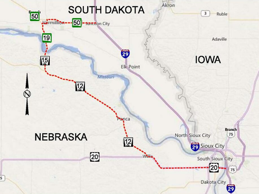
I-29 is going to be closed from Sioux City to the Vermillion exit for the next few days as they are going to divert some of the flood waters coming down the Big Sioux River to McCook Lake at North Sioux City.
-
Coyote
- City Council
- Posts: 34366
- Joined: Tue Nov 18, 2003 11:18 am
- Location: Aksarben Village
Re: Missouri River
The Missouri River Boat Club (Sioux City) is showing pics of dome high waters up there.
-
skinzfan23
- City Council
- Posts: 11569
- Joined: Mon Feb 09, 2004 11:26 am
- Location: Omaha/Bellevue
Re: Missouri River
According to the latest prediction, the river is going to crest at 29ft. Of course, it all depends on how much rain we get tonight. I am sure the totals are going to be a lot again. The main key though is how much rain falls up north.
-
skinzfan23
- City Council
- Posts: 11569
- Joined: Mon Feb 09, 2004 11:26 am
- Location: Omaha/Bellevue
Re: Missouri River
Looks like the river is receeding. It currently is under the "action" stage at just over 24ft. The crest was 27.94ft on 6/24/14, which ranks it the 8th highest crest all-time.
Historical Crests
(1) 40.20 ft on 04/18/1952
(2) 36.29 ft on 07/02/2011
(3) 34.22 ft on 04/25/1881
(4) 30.26 ft on 07/10/1993
(5) 29.50 ft on 06/23/1996
(6) 29.02 ft on 06/27/1984
(7) 28.74 ft on 07/01/2010
(8) 27.94 ft on 06/24/2014 (P)
(9) 26.89 ft on 06/17/1990
(10) 26.82 ft on 04/12/1969
Historical Crests
(1) 40.20 ft on 04/18/1952
(2) 36.29 ft on 07/02/2011
(3) 34.22 ft on 04/25/1881
(4) 30.26 ft on 07/10/1993
(5) 29.50 ft on 06/23/1996
(6) 29.02 ft on 06/27/1984
(7) 28.74 ft on 07/01/2010
(8) 27.94 ft on 06/24/2014 (P)
(9) 26.89 ft on 06/17/1990
(10) 26.82 ft on 04/12/1969
-
iamjacobm
- City Council
- Posts: 10796
- Joined: Sat Apr 10, 2010 6:52 am
- Location: Chicago
Re: Missouri River
Over 24 feet now, projecting to crest at 28.5
-
skinzfan23
- City Council
- Posts: 11569
- Joined: Mon Feb 09, 2004 11:26 am
- Location: Omaha/Bellevue
Re: Missouri River
Wow, I haven't looked at the numbers in quite a while but looking at the river I figured it was high. Yet another year where the crest is in the top 10 all-time.
-
iamjacobm
- City Council
- Posts: 10796
- Joined: Sat Apr 10, 2010 6:52 am
- Location: Chicago
Re: Missouri River
That was old, I just checked. Current projection shows just hitting above 30 on Thursday then dropping sharply.skinzfan23 wrote: Tue Jun 26, 2018 2:46 pmWow, I haven't looked at the numbers in quite a while but looking at the river I figured it was high. Yet another year where the crest is in the top 10 all-time.
https://water.weather.gov/ahps2/hydrogr ... gage=omhn1