The amount of water being released into the lower Missouri River will remain elevated at the start of the year, but should return to normal levels throughout 2019. The U.S. Army Corps of Engineers says the amount of water being released from Gavins Point Dam on the Nebraska-South Dakota border was recently increased to help clear out excess water collected last year. Those higher winter releases will help generate more power and clear out space for this spring's rain and melting snow.
The 49.9 million acre feet of water that flowed into the Missouri River's reservoirs last year was the third-highest level on record. This year, officials expect the amount of water to be close to the average amount of 25.3 million acre feet.
Looks like it is already listed at 7th highest crest, the current chart suggests it is currently at the 4th highest and potential to reach the third sometime this weekend.
There is a lot of water coming down from South Dakota. I have seen photos from around Sioux Falls and I have never seen the Sioux river across the falls that wild. Also Gavin’s point dam is releasing more water.
The Elkhorn River is flooding and evacuations have been ordered for western Douglas County. Maple is completely flooded over and Dodge is closed going westbound at 204th Street.
HR Paperstacks wrote: Fri Mar 15, 2019 3:14 pm
The Elkhorn River is flooding and evacuations have been ordered for western Douglas County. Maple is completely flooded over and Dodge is closed going westbound at 204th Street.
Jeffrey Robb / World-Herald staff writer wrote:Work is authorized to start immediately on:
West Dodge Road between U.S. Highway 275 and 228th Street. The state said the contract involves major work to rebuild the four lanes of West Dodge "to restore immediate connectivity." Hawkins Construction of Omaha has the contract.
U.S. 275/West Center Road. Constructors Inc. of Lincoln received the contract for repairs, which include a total bridge replacement and new pavement. The repairs involve the section between the Elkhorn River and the U.S. 275/Nebraska 92 junction.
U.S. Highway 30 between Fremont and Arlington. Part of the highway will be fully rebuilt. Omni Engineering of Omaha is the contractor.
U.S. Highway 77 north of Fremont, between U.S. 275 and Logan Creek. Traffic will be reduced to a single lane and led through with a pilot car. Thompson Construction of Fremont is the contractor.
Nebraska Highway 91 between Nickerson and Fontanelle. Part of the road will be fully rebuilt. Goree Excavating of Fremont has the contract.
Jeni Campana, spokesperson for the Department of Transportation, said the department does not currently have cost estimates or firm timelines for the work. Costs and timelines for each project will be released as soon as the department knows them, she said.
Nancy Gaarder / World-Herald staff writer wrote:Instead, Gavins Point’s main purpose is to smooth out widely fluctuating discharges from the much larger hydroelectric dam immediately upstream. If Gavins Point weren’t in place to do so, river levels downstream would rise and fall, perhaps multiple times and sometimes as much as five to six feet, on any given day. About 30 percent of the space behind Gavins Point Dam is set aside for flood control.
Nancy Gaarder / World-Herald staff writer wrote:Instead, Gavins Point’s main purpose is to smooth out widely fluctuating discharges from the much larger hydroelectric dam immediately upstream. If Gavins Point weren’t in place to do so, river levels downstream would rise and fall, perhaps multiple times and sometimes as much as five to six feet, on any given day. About 30 percent of the space behind Gavins Point Dam is set aside for flood control.
Despite it's apparent size, it is just a flow regulator. Amazing how much water the Corps though it needed to regulate flow for navigation. It would be interesting to see the summer flow rate data for the 1940s when these dams were conceptualized. The Mo must have really dropped a lot in those years.
I am interested in the part of this history from 1955 to 1993 when the river would go up a little, but never flood like it did in the late 1990s or 2011. What was different in this period compared to the years since?
Nancy Gaarder / World-Herald staff writer wrote:Instead, Gavins Point’s main purpose is to smooth out widely fluctuating discharges from the much larger hydroelectric dam immediately upstream. If Gavins Point weren’t in place to do so, river levels downstream would rise and fall, perhaps multiple times and sometimes as much as five to six feet, on any given day. About 30 percent of the space behind Gavins Point Dam is set aside for flood control.
Despite it's apparent size, it is just a flow regulator. Amazing how much water the Corps though it needed to regulate flow for navigation. It would be interesting to see the summer flow rate data for the 1940s when these dams were conceptualized. The Mo must have really dropped a lot in those years.
I am interested in the part of this history from 1955 to 1993 when the river would go up a little, but never flood like it did in the late 1990s or 2011. What was different in this period compared to the years since?
I posted this link in the 2019 severe weather thread, but it should probably be posted here too for future reference. USACE Missouri River Master Manual will give you an idea of how difficult it is to manage the river system, with all of the factors involved. There might be some of the history you seek in there too along with interesting data... It's a large file, so give it some time to load.
Lots of data regarding the implementing legislation..
One comment in the section on river prior to 1865: 3 million acre feet per year were diverted from the river for private use annually. That would imply that there was more than that present in the river.
Another was that the original navigation channel was from the mouth to KC and was intended to be 6 feet deep. So not much. The second navigation channel was from Sioux City to the mouth and 9 feet deep with 300 feet width. So for a mile of this channel, the river would have to have at least 14,256,000 cubic feet of water just in the channel. So the flow rate would have to be at least that much per second during the navigation season. Recognizing that the rivers downstream feed quite a bit of water into the river between Omaha and KC, but not so much between Sioux City and Omaha, it becomes understandable why all the other dams beside Ft Peck (the original dam for basic flood control.) were needed to provide that much water in dry years in order to keep that channel full all the way to Sioux City.
The interesting thing about the Pick Sloan program is that the legislation specifically gave the Corps control of the Republican river, where their flood control plan seems to work pretty well.
bigredmed1 wrote: Mon Apr 29, 2019 12:02 pm
The interesting thing about the Pick Sloan program is that the legislation specifically gave the Corps control of the Republican river, where their flood control plan seems to work pretty well.
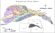
Not hard to control a river that has such a small drainage basin! But it will even fight back when mother nature has her way! 0.2 MB republican_river_basin.png Check Error
Last edited by GreenBuilderCW on Tue Apr 30, 2019 2:16 pm, edited 1 time in total.
bigredmed1 wrote: Mon Apr 29, 2019 12:02 pm
The interesting thing about the Pick Sloan program is that the legislation specifically gave the Corps control of the Republican river, where their flood control plan seems to work pretty well.
Not hard to control a river that has such a small drainage basin! But it will even fight back when mother nature has her way! 0.2 MB republican_river_basin.png Check Error
The interesting thing to me is that there are only three dams in the system and only one is on the river itself. The river has not had a lethal flood since. The discrepancy between the two rivers is considerable. Even considering the vast size difference between the two rivers.
Also, why has the Corps not asked for direct control over the Niobrara like it has over the Republican, or been more active in regulating the Elkhorn/Loup?
bigredmed1 wrote: Mon Apr 29, 2019 12:02 pm
The interesting thing about the Pick Sloan program is that the legislation specifically gave the Corps control of the Republican river, where their flood control plan seems to work pretty well.
Not hard to control a river that has such a small drainage basin! But it will even fight back when mother nature has her way! 0.2 MB republican_river_basin.png Check Error
The interesting thing to me is that there are only three dams in the system and only one is on the river itself. The river has not had a lethal flood since. The discrepancy between the two rivers is considerable. Even considering the vast size difference between the two rivers.
Also, why has the Corps not asked for direct control over the Niobrara like it has over the Republican, or been more active in regulating the Elkhorn/Loup?
The good article posted above by iamjacobm gets into the details about why there aren't more dams on the Platte and Elkhorn. Basically, on the plains, too much prime farm/ranch land would be lost by creating large reservoirs to justify the benefit. The land along the river valleys is actually fertile because of past flooding. Seems it's becoming more apparent that its OK to accept the risk of farming in the flood plain but maybe not building any permanent structures there.
Also, keep in mind there are only so many days available between warm and cold (frozen) seasons that will allow stored water to be evacuated to make room for the next big rain events. Once you have huge volumes of water stored, the potential for even bigger disasters increases dramatically, if you can't get rid of it fast enough.
Somewhere in the Corps master manual I remember seeing how much water from reservoirs is lost to evaporation during drought years. Seems like it was in the 1 mil acre/ft range. That's another interesting factor to think about.
He said "They are some big, ugly red brick buildings" ...and then they were gone.
Just wondering if anyone has a rough idea how long I-29 will be closed - specifically from Omaha to St Joseph? I've searched around online but everything I find is for earlier this year with the first round of flooding/closures...
Thanks, I have a friend coming through the area in a couple weeks so hoping it will reopen by then. Could be they just have no idea when it will open yet though...
I 29 N to St Joe
Hwy 36 West through St Jo into Ks
Hwy 75 N from 36 all the way into Omaha
Driven it a few times. Not nearly as bad as some want to make it out to be. Just takes a little longer.
Based on some photos from the Mills Co (Iowa) Emerg response that were new last week I think it is highly unlikely it will be open in a couple of weeks. But really, who knows.
For the record NEBUGEATER does not equal BUGEATER !!!!!!!
nebugeater wrote: Mon Jun 17, 2019 6:30 am
I 29 N to St Joe
Hwy 36 West through St Jo into Ks
Hwy 75 N from 36 all the way into Omaha
Driven it a few times. Not nearly as bad as some want to make it out to be. Just takes a little longer.
Based on some photos from the Mills Co (Iowa) Emerg response that were new last week I think it is highly unlikely it will be open in a couple of weeks. But really, who knows.
I like US-75 to Topeka, then on to KC--but it's not optimal. I've tried US-36 a few times (last during the 2011 flood), but there's a lot of 2-lane stop-n-go just west of STJ which absolutely kills time. Not good when you're stormchasing...
nebugeater wrote: Mon Jun 17, 2019 6:30 am
I 29 N to St Joe
Hwy 36 West through St Jo into Ks
Hwy 75 N from 36 all the way into Omaha
Driven it a few times. Not nearly as bad as some want to make it out to be. Just takes a little longer.
Based on some photos from the Mills Co (Iowa) Emerg response that were new last week I think it is highly unlikely it will be open in a couple of weeks. But really, who knows.
I like US-75 to Topeka, then on to KC--but it's not optimal. I've tried US-36 a few times (last during the 2011 flood), but there's a lot of 2-lane stop-n-go just west of STJ which absolutely kills time. Not good when you're stormchasing...
So far on this closure I have not had any stop and go on 36 but I know it happens. Going to Toleka works too but where I head is in N KC as a starting point so the 36 route works better for me
For the record NEBUGEATER does not equal BUGEATER !!!!!!!
nebugeater wrote: Mon Jun 17, 2019 6:30 am
I 29 N to St Joe
Hwy 36 West through St Jo into Ks
Hwy 75 N from 36 all the way into Omaha
Driven it a few times. Not nearly as bad as some want to make it out to be. Just takes a little longer.
Based on some photos from the Mills Co (Iowa) Emerg response that were new last week I think it is highly unlikely it will be open in a couple of weeks. But really, who knows.
I like US-75 to Topeka, then on to KC--but it's not optimal. I've tried US-36 a few times (last during the 2011 flood), but there's a lot of 2-lane stop-n-go just west of STJ which absolutely kills time. Not good when you're stormchasing...
I wonder if in the long run the government would've saved money by building the interstate on the Nebraska dude if the river out of the floodplain.
daveoma wrote: Mon Jun 17, 2019 11:14 am
I wonder if in the long run the government would've saved money by building the interstate on the Nebraska dude if the river out of the floodplain.
it's a fair question. Probably a case of pay me now or pay me later. It's later...:-)
daveoma wrote: Mon Jun 17, 2019 11:14 am
I wonder if in the long run the government would've saved money by building the interstate on the Nebraska dude if the river out of the floodplain.
it's a fair question. Probably a case of pay me now or pay me later. It's later...:-)
When they repaired it in 2011, why they didn’t raise the bed to 2 feet above the 2011 waterline is something I would be interested in.
daveoma wrote: Mon Jun 17, 2019 11:14 am
I wonder if in the long run the government would've saved money by building the interstate on the Nebraska dude if the river out of the floodplain.
it's a fair question. Probably a case of pay me now or pay me later. It's later...:-)
When they repaired it in 2011, why they didn’t raise the bed to 2 feet above the 2011 waterline is something I would be interested in.
From what I heard and understand, they had to restore it the way it was before the flood to get FEMA or money assistance. If they made any changes, they would not get FEMA or money assistance. Plus any changes would need to be approved before they could make the changes. That is why it takes years to get changes done. Just look at how long it took for the Council Bluffs I29/I80 changes to start after they started planning.
daveoma wrote: Mon Jun 17, 2019 11:14 am
I wonder if in the long run the government would've saved money by building the interstate on the Nebraska dude if the river out of the floodplain.
it's a fair question. Probably a case of pay me now or pay me later. It's later...:-)
When they repaired it in 2011, why they didn’t raise the bed to 2 feet above the 2011 waterline is something I would be interested in.
From what I heard and understand, they had to restore it the way it was before the flood to get FEMA or money assistance. If they made any changes, they would not get FEMA or money assistance. Plus any changes would need to be approved before they could make the changes. That is why it takes years to get changes done. Just look at how long it took for the Council Bluffs I29/I80 changes to start after they started planning.
This is unbelievable. A slow motion disaster, and even slower to resolve itself.
Will this be the new normal? Every two or three years no direct route between two nearby major metropolitan areas?
Thankfully, no one has been struck down by boils, but there have been reports of bugs caking windshields so thick on stretches of road between Omaha and Kansas City that drivers have to pull over to clean up the mess.
They’ve sold out of windshield wiper fluid at Dominator Fuel in Rock Port, Missouri. Other gas stations report they’ve gone through twice the usual amount.
nativeomahan wrote: Tue Jun 18, 2019 5:53 pm
This is unbelievable. A slow motion disaster, and even slower to resolve itself.
Will this be the new normal? Every two or three years no direct route between two nearby major metropolitan areas?
The MO has historically behaved like this. It used to be at the base of Council bluff, DeSoto Bend used to not exist and that stretch was straight, and Hamburg was a riverport.
The Corps only has titular control over the MO and the Republican. All other tributaries have shared control.
During the 1970-90 era, the Niobrara, Elkhorn, and the Dismal were declared Wilderness rivers and flood control was made much more difficult. This era was considerably drier than the last 10 years dulling people’s sense of risk.
The Corps have now encountered sub-GP flood problems in 1998 and 2019 as well as several years of high water and they really have done little to address the flood risk.
We need to amend Pick Sloan to give the Corps more senior status over more rivers and they need to partner with places like NM State and other engineering schools that have significant research bases in controlling water surges and get creative with the MO system and the MISS sub-GP tributaries. We can’t stop every flood, but we should be able to learn from this year’s experience on the Republican where we should have seen it go full beast mode like it used to but instead just got high water downstream from Harlan.
Things need to get better and then keep getting better.
Think about it this way next time you’re driving up I-29 between Iowa and Nebraska: Look at the bluffs to your east. Look at the bluffs to your west. The Missouri made all the flat area in between. Maybe not all at once, but over time, but make no mistake, the mighty Mo could come back and claim it at any time (barring proper channelization procedures),