2020 Weather Thread
-
stormchaser
- Planning Board
- Posts: 2380
- Joined: Fri Jun 01, 2018 1:14 pm
Re: 2020 Severe Weather Thread
Next severe weather risk currently in the eastern half of NE looks to be this coming Saturday/Saturday evening. Too far out yet to be confident but perhaps the risk for supercells and tornadoes based on current model trends anyway. Something to keep an eye on.
-
damonhynes

- Parks & Recreation
- Posts: 1282
- Joined: Wed Aug 27, 2014 12:35 am
- Location: Montgomery County, Texas
Re: 2020 Severe Weather Thread
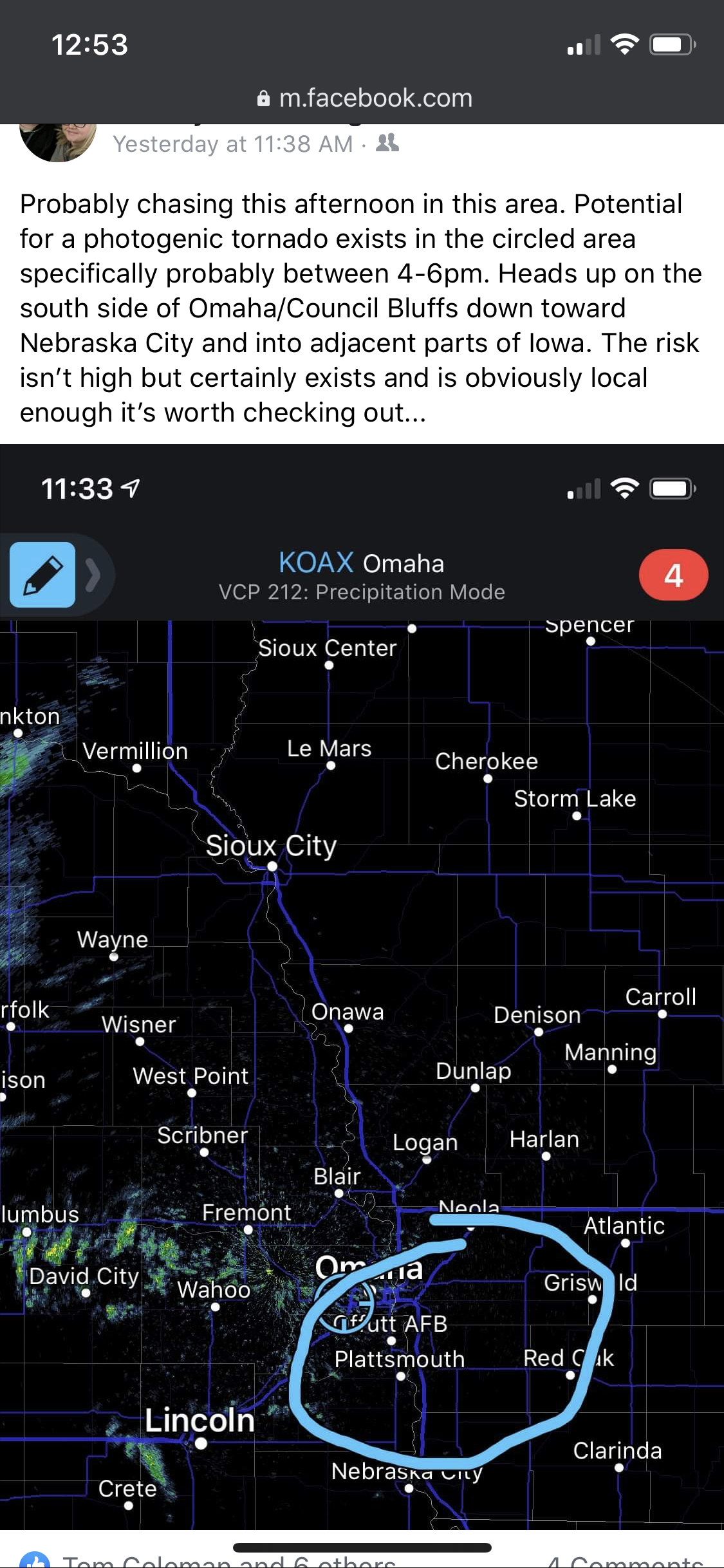
Props given where due. Good job!stormchaser wrote: Sun May 17, 2020 5:58 pm For what it’s worth (which I realize isn’t probably a lot) my forecast I posted on FB ended up being pretty accurate about 6 hours prior to the storm occurring...
-
stormchaser
- Planning Board
- Posts: 2380
- Joined: Fri Jun 01, 2018 1:14 pm
Re: 2020 Severe Weather Thread
Thanks!
As I mentioned yesterday, next main threat for severe weather in our area appears to be this coming Saturday. However, some timing and consequently location differences exist between both long range models for as to where exactly the highest tornado threat will be.
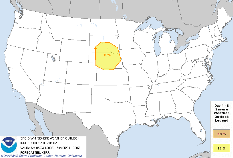
The ECMWF shows the tornado threat area mainly around McCook/North Platte (roughly). The GFS would be further east with that threat more in south central NE - possibly as Far east as Lincoln/Beatrice. In most cases, typically the ECMWF is the more favored long range model but the timing/location differences are something to be aware of. Hopefully medium range models will offer some clarity once in better range.
For the rest of central/eastern NE (including Omaha), this will probably be a fairly widespread damaging wind/hail event with storms probably rolling into Lincoln/Omaha Saturday night.
As of this morning, the SPC has put out an official “day 4” risk area showing the potential areas at risk (though I’m sure it will change some - image included below). Additional severe weather is possible for parts of the area late Friday night and again on Sunday depending on timing of when the storm system pushes through...but Saturday will be the primary day for most.
-
stormchaser
- Planning Board
- Posts: 2380
- Joined: Fri Jun 01, 2018 1:14 pm
Re: 2020 Severe Weather Thread
Just figured I'd post an update - if anything strong/severe happens in the Omaha area Saturday it won't be until night time. Models have been trending west and north with the severe weather threat so locally anyway the threat has decreased until at the very least Saturday night (and that may not happen either).
That being said, the threat for tomorrow/tomorrow evening is starting to increase for south of Omaha and southwest Iowa (especially) as a conditional tornado threat exists. This will depend on if things are able to clear out enough in that area for things to destabilize and consequently if storms are able to reach their full potential/are able to sustain themselves. If they can, it may be a repeat of last Saturday with a tornadic storm or 2 just ahead of the area of low pressure pushing through the area. Just know if you live south of Omaha or in southwest Iowa, keep an eye on things. Odds are low but certainly needs to be watched closely. This would be the type of setup to catch people off guard....
That being said, the threat for tomorrow/tomorrow evening is starting to increase for south of Omaha and southwest Iowa (especially) as a conditional tornado threat exists. This will depend on if things are able to clear out enough in that area for things to destabilize and consequently if storms are able to reach their full potential/are able to sustain themselves. If they can, it may be a repeat of last Saturday with a tornadic storm or 2 just ahead of the area of low pressure pushing through the area. Just know if you live south of Omaha or in southwest Iowa, keep an eye on things. Odds are low but certainly needs to be watched closely. This would be the type of setup to catch people off guard....
-
stormchaser
- Planning Board
- Posts: 2380
- Joined: Fri Jun 01, 2018 1:14 pm
Re: 2020 Severe Weather Thread
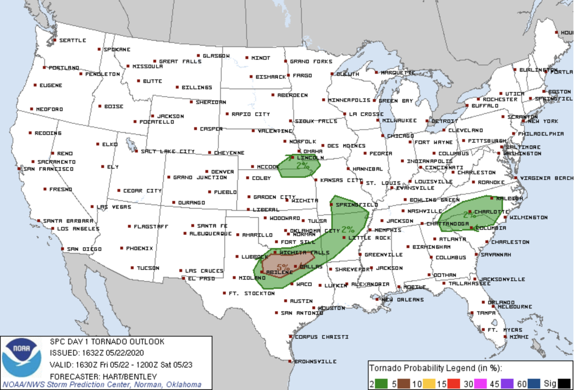
Odds that a few supercells and potentially tornadic storms (though risk is low) continue to increase. SPC has just now issued a tornado risk for south of Omaha. Heads up late this afternoon into this evening if you live in this area. Right now I'm leaning towards targeting somewhere between Auburn to Beatrice down toward the Falls City area...
-
stormchaser
- Planning Board
- Posts: 2380
- Joined: Fri Jun 01, 2018 1:14 pm
Re: 2020 Severe Weather Thread
Depending on potential capping issues, there is a chance there will be a few isolated tornadoes on Thursday in northeastern NE followed by storms growing upscale into a line of storms dropping south/southeast into the evening hours with a fairly widespread damaging wind event across eastern NE - including Omaha (potentially at least). Something to keep an eye on anyway...
-
Omaha Cowboy

- The Don
- Posts: 1013737
- Joined: Wed Jan 07, 2004 11:31 am
- Location: West Omaha
Re: 2020 Severe Weather Thread
I saw on KETV this morning that the Omaha area is in the Slight Risk category for severe weather (Thursday 6/4) late afternoon into the evening...stormchaser wrote: Tue Jun 02, 2020 4:25 pm Depending on potential capping issues, there is a chance there will be a few isolated tornadoes on Thursday in northeastern NE followed by storms growing upscale into a line of storms dropping south/southeast into the evening hours with a fairly widespread damaging wind event across eastern NE - including Omaha (potentially at least). Something to keep an eye on anyway...
Ciao..LiO...Peace
Go Cowboys!
-
Busguy2010

- City Council
- Posts: 7393
- Joined: Sun Apr 10, 2011 12:32 am
- Location: North Central Omaha
Re: 2020 Severe Weather Thread
Earlier today we were very solidly in the slight risk, but now the area has moved northeast, and we are only on the skirts of that area as of the update last hour. Currently only at a 40% chance for tomorrow, but the NWS is using the language "severe thunderstorms" in their forecast for tomorrow. So something very well could happen.Omaha Cowboy wrote: Wed Jun 03, 2020 3:13 pmI saw on KETV this morning that the Omaha area is in the Slight Risk category for severe weather (Thursday 6/4) late afternoon into the evening...stormchaser wrote: Tue Jun 02, 2020 4:25 pm Depending on potential capping issues, there is a chance there will be a few isolated tornadoes on Thursday in northeastern NE followed by storms growing upscale into a line of storms dropping south/southeast into the evening hours with a fairly widespread damaging wind event across eastern NE - including Omaha (potentially at least). Something to keep an eye on anyway...
Ciao..LiO...Peace
-
stormchaser
- Planning Board
- Posts: 2380
- Joined: Fri Jun 01, 2018 1:14 pm
Re: 2020 Severe Weather Thread
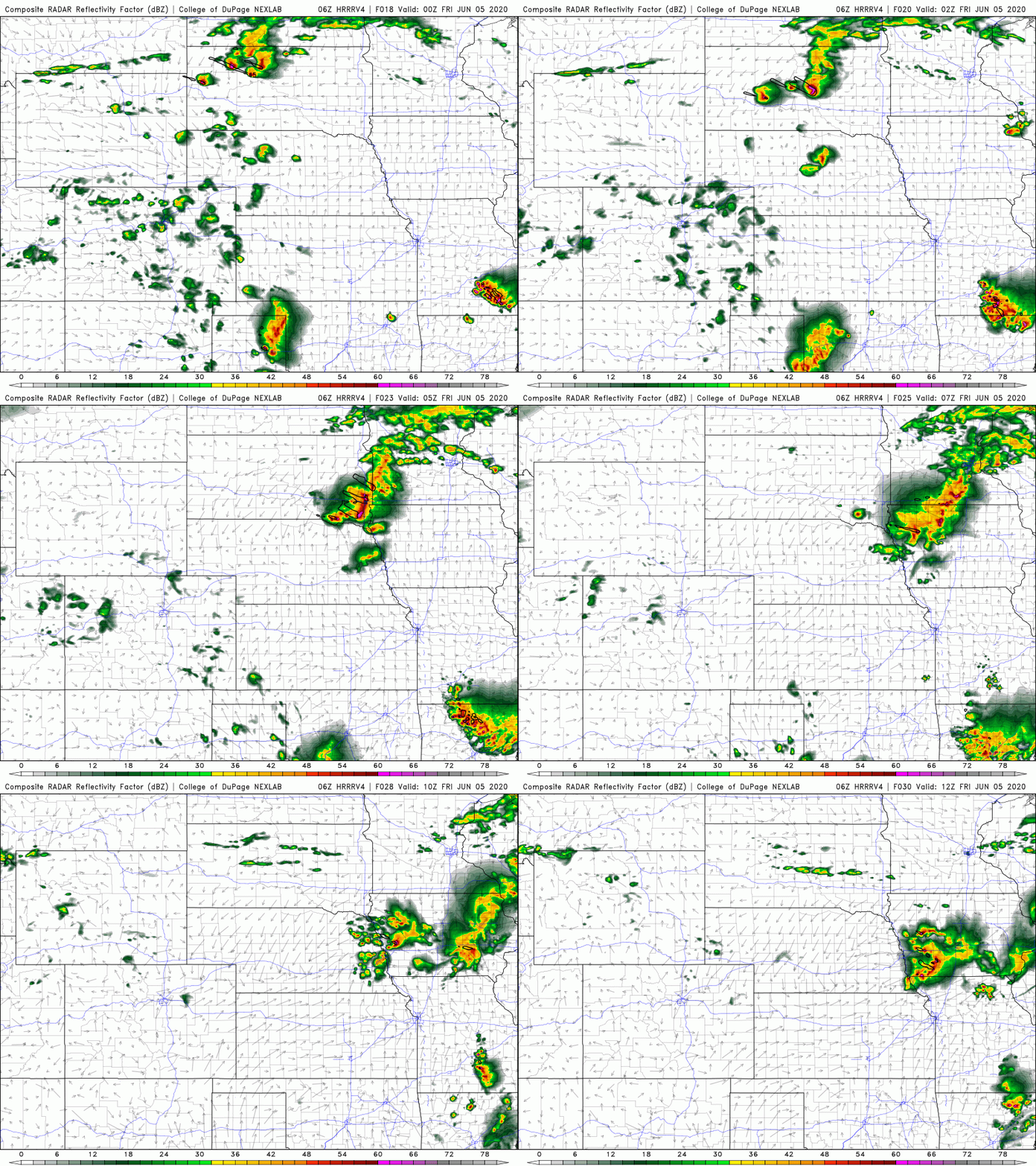
Based on the latest model guidance (the 06z HRRRv4 in this particular case anyway), it continues to look like much of the Omaha area will remain "capped" (in other words it will be too warm aloft for storm activity) with most of the storms staying to our north where it will be slightly cooler aloft with an isolated tornado threat but predominantly a damaging wind event. However, there is a chance that storms will eventually fire in the local area late tonight, well after midnight once things cool off enough aloft for updrafts to be able to sustain themselves/continue to rise - possibly even after 3AM in the local area.
If this happens, damaging wind and hail will be the main concerns though with the easterly/southeasterly surface winds being depicted and southeasterly storm motion, any storms that can remain isolated enough would pose some risk of becoming supercellular early on as they first fire with a slight risk for a brief tornado or 2 (though extremely unlikely as storms will likely be elevated by this time) - large/damaging hail would be the more likely risk if this were to happen. This threat would be enhanced in any areas where outflow boundaries exist from storms that push through to our north earlier in the evening. However, the storms should quickly transition into more of a damaging wind threat though (again, assuming they actually fire) as they drop southeast.
Below is an animation of the simulated radar from the 06z HRRRv4 starting at 6PM this evening and ending at 6AM tomorrow morning...
If this happens, damaging wind and hail will be the main concerns though with the easterly/southeasterly surface winds being depicted and southeasterly storm motion, any storms that can remain isolated enough would pose some risk of becoming supercellular early on as they first fire with a slight risk for a brief tornado or 2 (though extremely unlikely as storms will likely be elevated by this time) - large/damaging hail would be the more likely risk if this were to happen. This threat would be enhanced in any areas where outflow boundaries exist from storms that push through to our north earlier in the evening. However, the storms should quickly transition into more of a damaging wind threat though (again, assuming they actually fire) as they drop southeast.
Below is an animation of the simulated radar from the 06z HRRRv4 starting at 6PM this evening and ending at 6AM tomorrow morning...
-
Omaha Cowboy
- The Don
- Posts: 1013737
- Joined: Wed Jan 07, 2004 11:31 am
- Location: West Omaha
Re: 2020 Severe Weather Thread
This morning, KETV still shows Omaha in the Slight Risk area.. Stormchasers data suggests an overnight or early AM event. We’ll see...Busguy2010 wrote: Wed Jun 03, 2020 8:37 pmEarlier today we were very solidly in the slight risk, but now the area has moved northeast, and we are only on the skirts of that area as of the update last hour. Currently only at a 40% chance for tomorrow, but the NWS is using the language "severe thunderstorms" in their forecast for tomorrow. So something very well could happen.Omaha Cowboy wrote: Wed Jun 03, 2020 3:13 pmI saw on KETV this morning that the Omaha area is in the Slight Risk category for severe weather (Thursday 6/4) late afternoon into the evening...stormchaser wrote: Tue Jun 02, 2020 4:25 pm Depending on potential capping issues, there is a chance there will be a few isolated tornadoes on Thursday in northeastern NE followed by storms growing upscale into a line of storms dropping south/southeast into the evening hours with a fairly widespread damaging wind event across eastern NE - including Omaha (potentially at least). Something to keep an eye on anyway...
Ciao..LiO...Peace
Ciao..LiO...Peace
Go Cowboys!
-
stormchaser
- Planning Board
- Posts: 2380
- Joined: Fri Jun 01, 2018 1:14 pm
Re: 2020 Severe Weather Thread
Yep, it will be interesting to see how things play out. It's worth noting, many of the storms that will effect our region will probably originate this afternoon near the Wyoming/Montana border and move southeast from there into South Dakota and eventually down into our area late tonight as they ride along the edge of the ridge (i.e. boundary of warm temps aloft aka the cap). These storms will likely produce some pretty large hail (possibly baseball sized or larger even) in parts of western/central SD. It will be interesting to see how well they sustain themselves as they move our way or if they will collapse and then produce new storms along the outflow boundary ahead of the initial storms...or if they just collapse and end up producing nothing of note. Long story short, lots of unknowns still as far as what to expect locally. Regardless, it will all almost certainly be well after midnight here.Omaha Cowboy wrote: Thu Jun 04, 2020 2:30 pmThis morning, KETV still shows Omaha in the Slight Risk area.. Stormchasers data suggests an overnight or early AM event. We’ll see...Busguy2010 wrote: Wed Jun 03, 2020 8:37 pmEarlier today we were very solidly in the slight risk, but now the area has moved northeast, and we are only on the skirts of that area as of the update last hour. Currently only at a 40% chance for tomorrow, but the NWS is using the language "severe thunderstorms" in their forecast for tomorrow. So something very well could happen.Omaha Cowboy wrote: Wed Jun 03, 2020 3:13 pmI saw on KETV this morning that the Omaha area is in the Slight Risk category for severe weather (Thursday 6/4) late afternoon into the evening...stormchaser wrote: Tue Jun 02, 2020 4:25 pm Depending on potential capping issues, there is a chance there will be a few isolated tornadoes on Thursday in northeastern NE followed by storms growing upscale into a line of storms dropping south/southeast into the evening hours with a fairly widespread damaging wind event across eastern NE - including Omaha (potentially at least). Something to keep an eye on anyway...
Ciao..LiO...Peace
Ciao..LiO...Peace
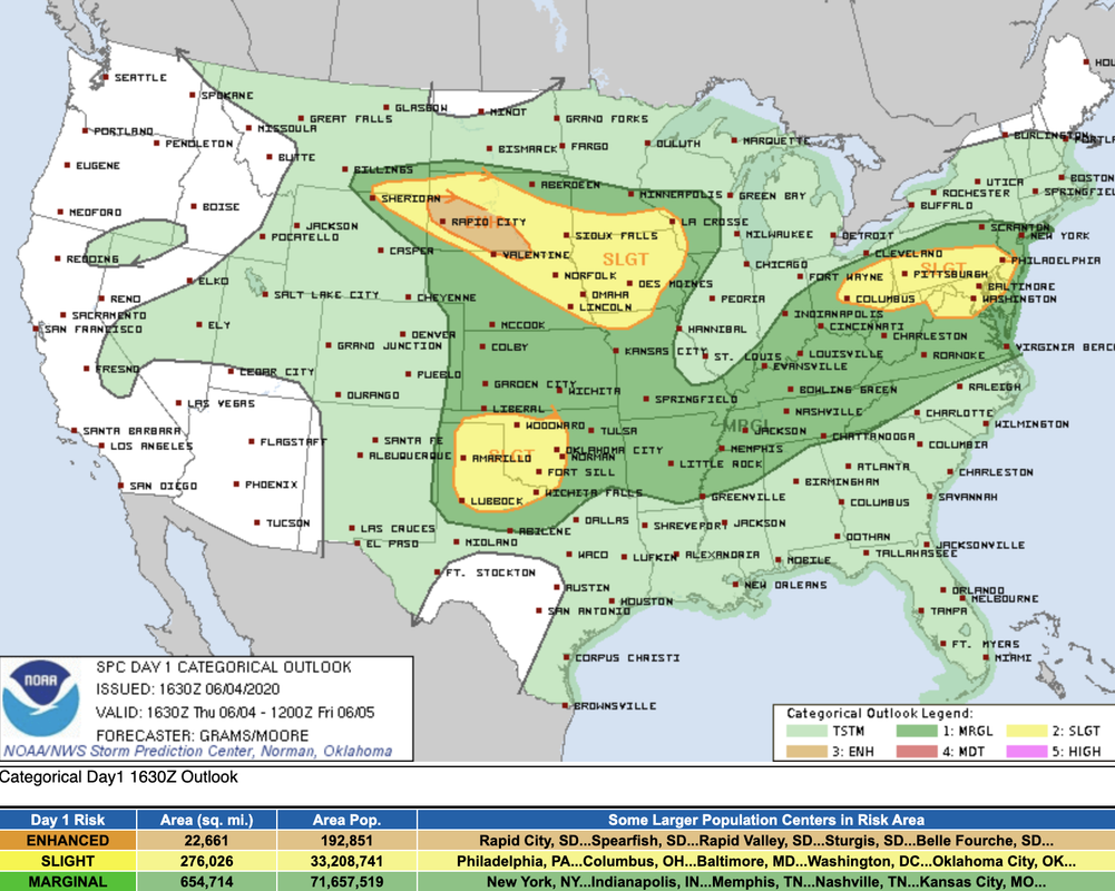
Just as I was posting the above info, SPC updated their severe weather outlook for the day. It now includes more of the Lincoln/Omaha area which isn't completely surprising based on the latest model guidance.
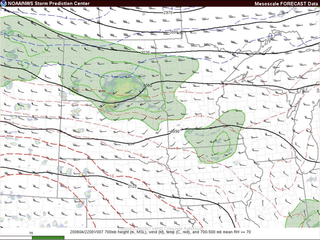
For reference, below are the 700mb temps for around 5PM this evening based on the RAP forecast model (just to give you a rough idea of what we look at - 700mb represents a level in the atmosphere just above where storms often form in which case if it's too warm, the rising column of warm air known as an "updraft" can no longer rise through this level and become a mature storm because it's no longer "warmer" in comparison to the air at that level). The 700mb temps allows forecasters to at least roughly see where the cap is located. Long story short, anywhere along and north of the red dashed line that says "10" (which is draped across Nebraska) should have temps cool enough aloft for strong/severe storms. Anywhere between the 10 and 12 dashed lines would be a "maybe". Anywhere south of the 12 dashed lines will likely be too warm aloft for storms to form and/or to really sustain themselves (at least nothing widespread). Obviously there are more factors than this, but this is a good example of what people mean when they say the atmosphere is "capped". It's also why during the summer time you'll often get storm development near sunset - as the upper levels cool off enough for storm development. Anyhow, enough of me weather geeking though

-
Omaha Cowboy
- The Don
- Posts: 1013737
- Joined: Wed Jan 07, 2004 11:31 am
- Location: West Omaha
Re: 2020 Severe Weather Thread
Excellent insight here. Thanks stormchaserstormchaser wrote: Thu Jun 04, 2020 4:44 pmYep, it will be interesting to see how things play out. It's worth noting, many of the storms that will effect our region will probably originate this afternoon near the Wyoming/Montana border and move southeast from there into South Dakota and eventually down into our area late tonight as they ride along the edge of the ridge (i.e. boundary of warm temps aloft aka the cap). These storms will likely produce some pretty large hail (possibly baseball sized or larger even) in parts of western/central SD. It will be interesting to see how well they sustain themselves as they move our way or if they will collapse and then produce new storms along the outflow boundary ahead of the initial storms...or if they just collapse and end up producing nothing of note. Long story short, lots of unknowns still as far as what to expect locally. Regardless, it will all almost certainly be well after midnight here.Omaha Cowboy wrote: Thu Jun 04, 2020 2:30 pmThis morning, KETV still shows Omaha in the Slight Risk area.. Stormchasers data suggests an overnight or early AM event. We’ll see...Busguy2010 wrote: Wed Jun 03, 2020 8:37 pmEarlier today we were very solidly in the slight risk, but now the area has moved northeast, and we are only on the skirts of that area as of the update last hour. Currently only at a 40% chance for tomorrow, but the NWS is using the language "severe thunderstorms" in their forecast for tomorrow. So something very well could happen.Omaha Cowboy wrote: Wed Jun 03, 2020 3:13 pmI saw on KETV this morning that the Omaha area is in the Slight Risk category for severe weather (Thursday 6/4) late afternoon into the evening...stormchaser wrote: Tue Jun 02, 2020 4:25 pm Depending on potential capping issues, there is a chance there will be a few isolated tornadoes on Thursday in northeastern NE followed by storms growing upscale into a line of storms dropping south/southeast into the evening hours with a fairly widespread damaging wind event across eastern NE - including Omaha (potentially at least). Something to keep an eye on anyway...
Ciao..LiO...Peace
Ciao..LiO...Peace
Just as I was posting the above info, SPC updated their severe weather outlook for the day. It now includes more of the Lincoln/Omaha area which isn't completely surprising based on the latest model guidance.
For reference, below are the 700mb temps for around 5PM this evening based on the RAP forecast model (just to give you a rough idea of what we look at - 700mb represents a level in the atmosphere just above where storms often form in which case if it's too warm, the rising column of warm air known as an "updraft" can no longer rise through this level and become a mature storm because it's no longer "warmer" in comparison to the air at that level). The 700mb temps allows forecasters to at least roughly see where the cap is located. Long story short, anywhere along and north of the red dashed line that says "10" (which is draped across Nebraska) should have temps cool enough aloft for strong/severe storms. Anywhere between the 10 and 12 dashed lines would be a "maybe". Anywhere south of the 12 dashed lines will likely be too warm aloft for storms to form and/or to really sustain themselves (at least nothing widespread). Obviously there are more factors than this, but this is a good example of what people mean when they say the atmosphere is "capped". It's also why during the summer time you'll often get storm development near sunset - as the upper levels cool off enough for storm development. Anyhow, enough of me weather geeking though
 ...
Ciao..LiO...Peace
Go Cowboys!
-
stormchaser
- Planning Board
- Posts: 2380
- Joined: Fri Jun 01, 2018 1:14 pm
Re: 2020 Severe Weather Thread
Thanks!
Probably should say odds are quickly increasing of a damaging wind event over the next several hours for much of the eastern half of Nebraska. I wouldn’t be surprised if a weather watch is issued soon as a line of storms is organizing/strengthening in central parts of the state currently and appear they’ll maintain their strength for a while. I’d expect damaging wind in Omaha and Lincoln in a few hours...
Probably should say odds are quickly increasing of a damaging wind event over the next several hours for much of the eastern half of Nebraska. I wouldn’t be surprised if a weather watch is issued soon as a line of storms is organizing/strengthening in central parts of the state currently and appear they’ll maintain their strength for a while. I’d expect damaging wind in Omaha and Lincoln in a few hours...
Last edited by stormchaser on Fri Jun 05, 2020 2:07 am, edited 1 time in total.
-
stormchaser
- Planning Board
- Posts: 2380
- Joined: Fri Jun 01, 2018 1:14 pm
Re: 2020 Severe Weather Thread
...and just like that. Watch issued though it doesn’t include Omaha itself (just to our west). May end up being more than 1 round of storms in the area. First around 11 or 12 the other a few hours later as storms drop out of SD
-
Busguy2010
- City Council
- Posts: 7393
- Joined: Sun Apr 10, 2011 12:32 am
- Location: North Central Omaha
Re: 2020 Severe Weather Thread
Around 12:15 I went outside and was greeted by a good light show to my southwest. In North Central, only got a drop or two of rain, but had a clear view of all the lightning bunched up in the thunder cloud. Never looked at the radar to see where it was exactly. Had some brief outflow gusts probably close to 40 mph, but nothing major. It was far enough away I saw hundreds of flashes, but only a handful of quiet rumbles. It was quite pleasant to watch, even though it was another OmaDud.
-
Busguy2010
- City Council
- Posts: 7393
- Joined: Sun Apr 10, 2011 12:32 am
- Location: North Central Omaha
Re: 2020 Severe Weather Thread
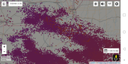
Looks like it was a crazy light show to our southwest. What I was seeing was probably a small cell that flared up over Gretna, parts of Millard.
-
stormchaser
- Planning Board
- Posts: 2380
- Joined: Fri Jun 01, 2018 1:14 pm
Re: 2020 Severe Weather Thread
Yep, fun stuff passed near Gretna and then down toward Lincoln where there was 70+ mph winds reported. I'm assuming some trees down in that area but Omaha itself was spared...bummer ;)
-
stormchaser
- Planning Board
- Posts: 2380
- Joined: Fri Jun 01, 2018 1:14 pm
Re: 2020 Severe Weather Thread
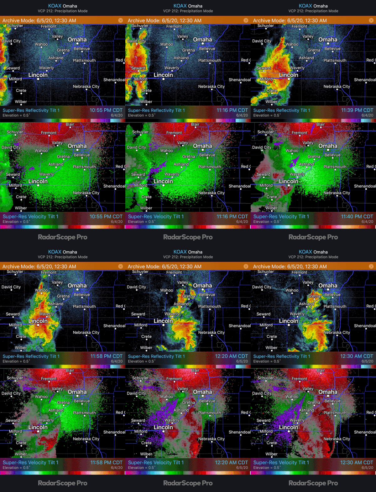
High-res radar recap of the storms moving through the area last night. On the base velocities, you can see where the strongest winds (70+mph) pushed through Lincoln and then tried to curl up toward the Omaha area before weakening. Sometimes these will rotate and produce weak tornadoes but it didn't happen this time though it tried anyway near Ashland (known as a "bookend vortex" the spinning motion created is very similar to the spinning motion made in water when you’re rowing a paddle through it)
-
Busguy2010
- City Council
- Posts: 7393
- Joined: Sun Apr 10, 2011 12:32 am
- Location: North Central Omaha
Re: 2020 Severe Weather Thread
Pretty cool to see that outflow boundary that I was feeling last night. I'm surprised that it came from the honker that went through Lincoln, and not the little guy that over Gretna. Amazing how a storm 60 miles away can have that affect.
-
stormchaser
- Planning Board
- Posts: 2380
- Joined: Fri Jun 01, 2018 1:14 pm
Re: 2020 Severe Weather Thread
Pretty cool storm that developed on what “appeared” to be a boundary that curled around the eastern side of the city (perhaps the “heat island effect” at work) before it collapsed on itself (as you can see by the outflow boundaries from the rain cooled air rushing away from the storm) - mostly as a result of barely moving. Just amazing the physics at work with weather/storms ;)
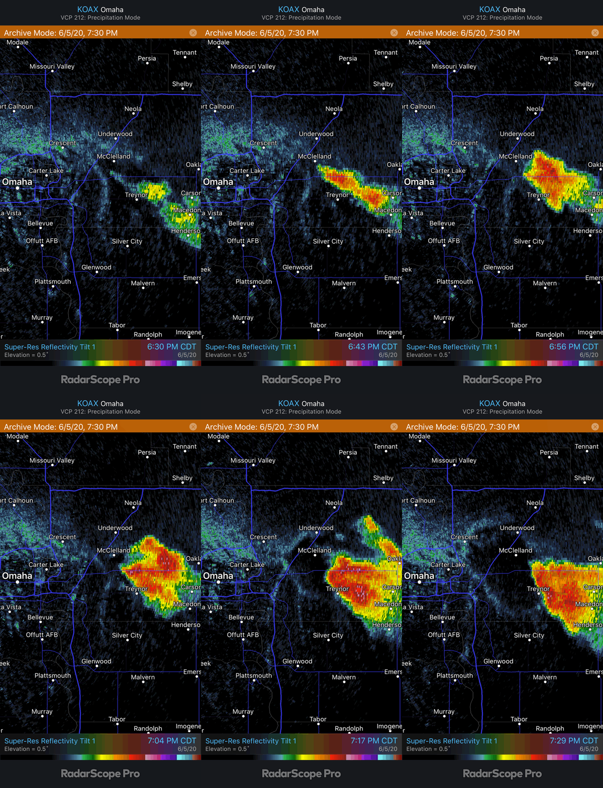
I was out chasing it, it tried to briefly wrap up but ultimately it undercut itself and died..
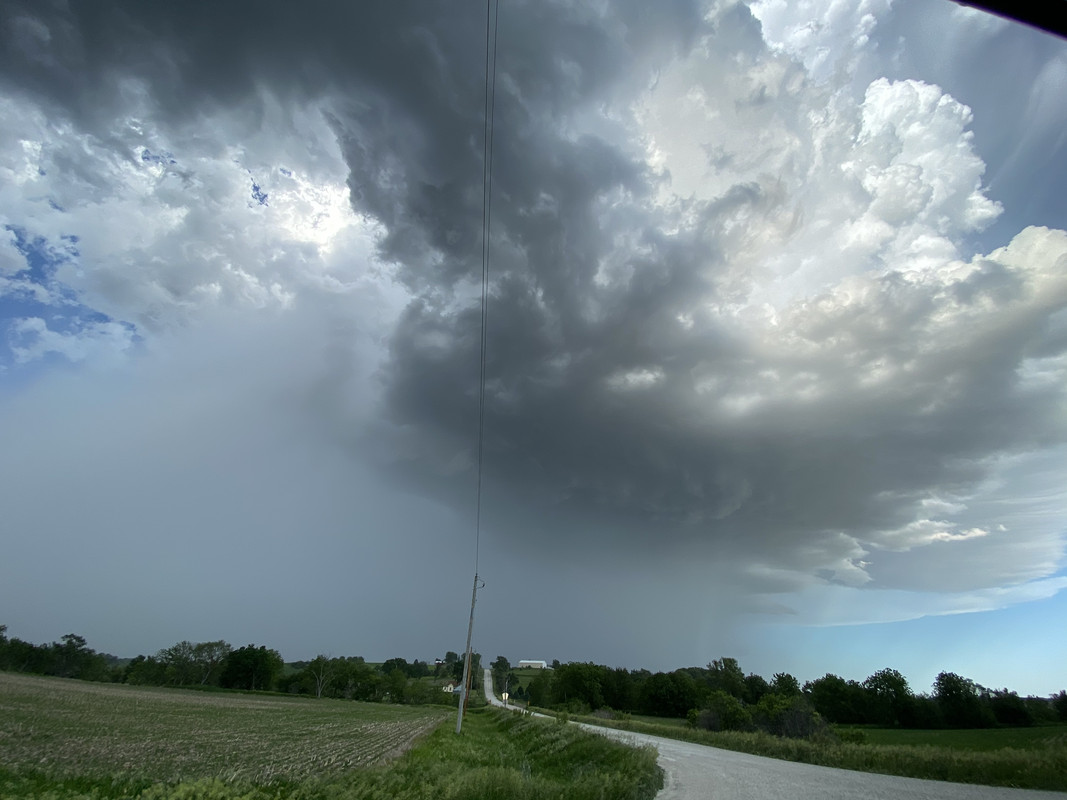
I was out chasing it, it tried to briefly wrap up but ultimately it undercut itself and died..
-
damonhynes
- Parks & Recreation
- Posts: 1282
- Joined: Wed Aug 27, 2014 12:35 am
- Location: Montgomery County, Texas
Re: 2020 Severe Weather Thread
The prettiest storm I've seen in years! Rule #314159 of storm-chasing--never turn your back on a wind-shift or OFB!
-
Coyote
- City Council
- Posts: 34365
- Joined: Tue Nov 18, 2003 5:18 pm
- Yahoo Messenger: jestcoyote
- Location: Aksarben Village
Re: 2020 Severe Weather Thread
You do not have the required permissions to view the files attached to this post.
-
stormchaser
- Planning Board
- Posts: 2380
- Joined: Fri Jun 01, 2018 1:14 pm
Re: 2020 Severe Weather Thread
Gotta love OFBsdamonhynes wrote: Sun Jun 07, 2020 6:52 pmThe prettiest storm I've seen in years! Rule #314159 of storm-chasing--never turn your back on a wind-shift or OFB!
.Tomorrow likes like an interesting severe weather day in central and western parts of Nebraska. Highest tornado potential probably from near North Platte down toward McCook and up toward Kearney.
Tuesday is starting to look like a potential tornado day in southeast NE and/or southwest IA near a low and warm front pushing through the area. This honestly could be a fairly big tornado day in the local area depending exactly how things come together and if storms can remain discrete enough. Too far out to feel confident yet regardless...
-
stormchaser
- Planning Board
- Posts: 2380
- Joined: Fri Jun 01, 2018 1:14 pm
Re: 2020 Severe Weather Thread
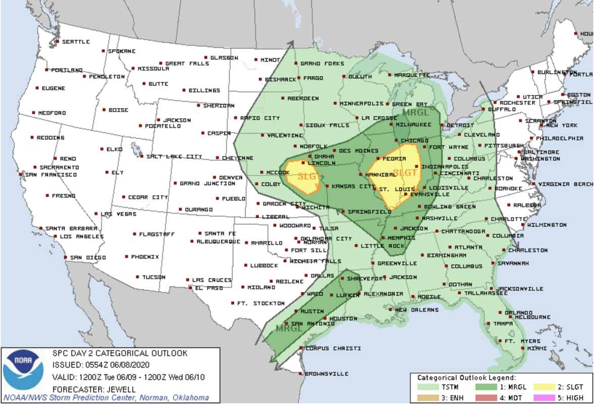
Storm Prediction Center now has a slight risk out for far southeast Nebraska for tomorrow. I'm wondering if this risk area will be shifted north some to possibly include the Omaha area (or just barely south of town) as well. There is some disagreement on models as far as the exact location of the low/warm front and consequently exactly where storms should be expected tomorrow though most agree storms will form sometime between 3PM and 6PM.
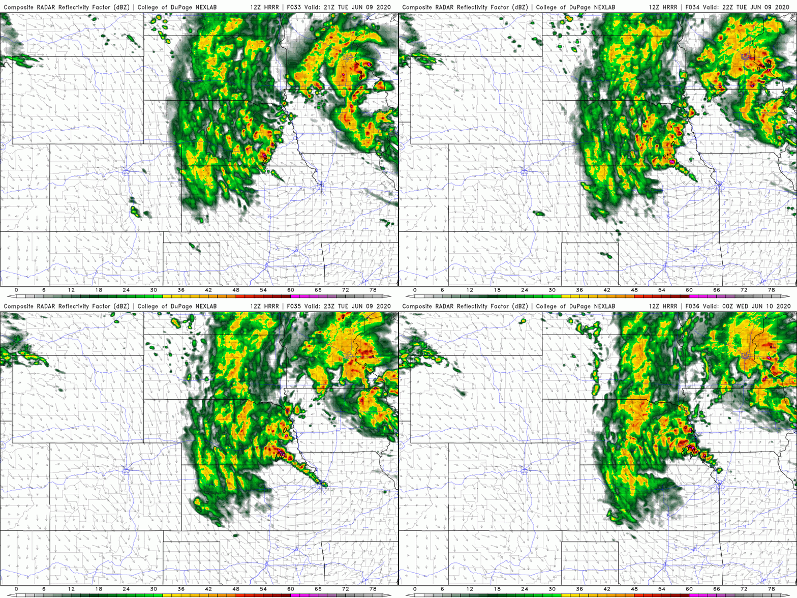
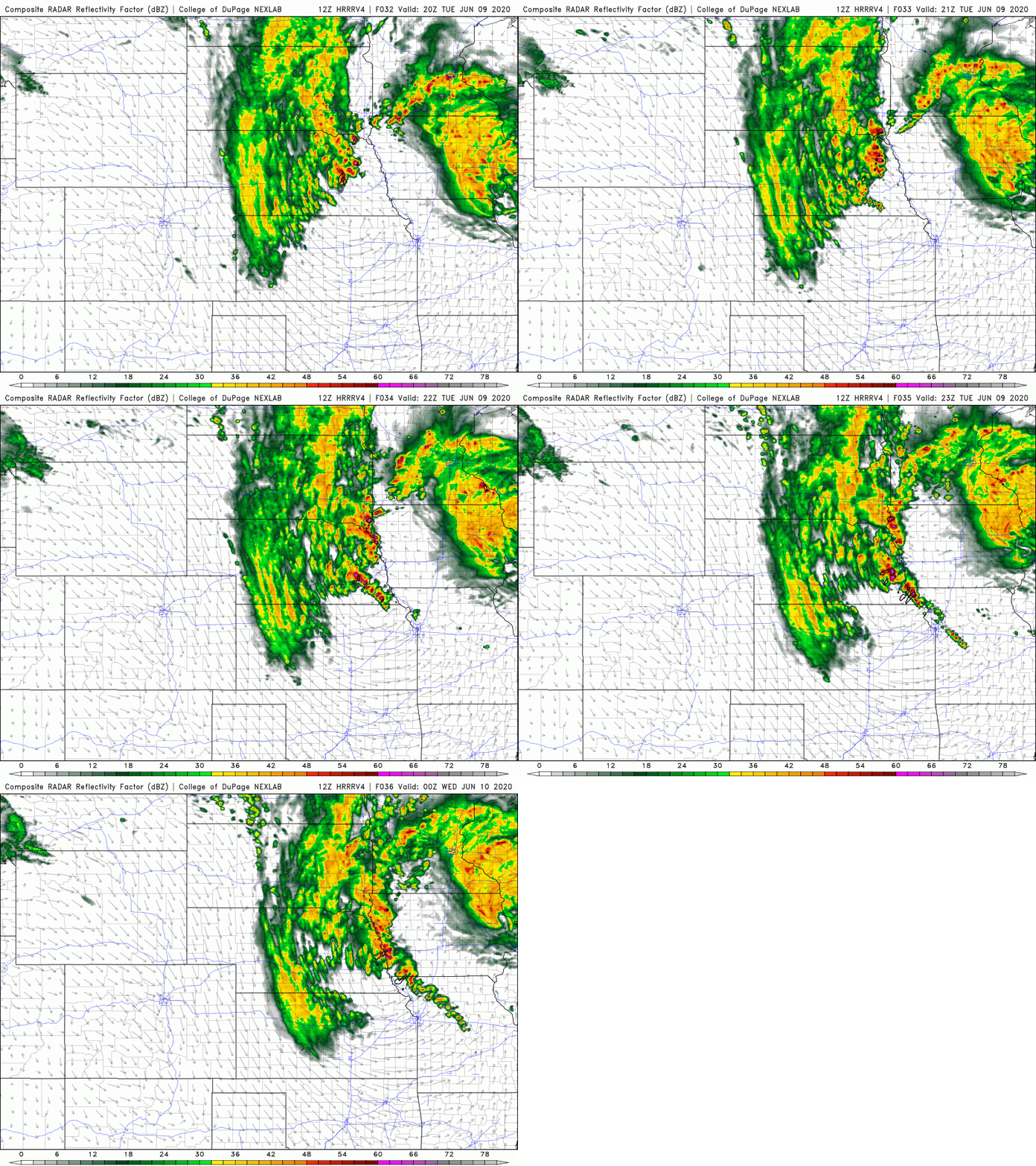
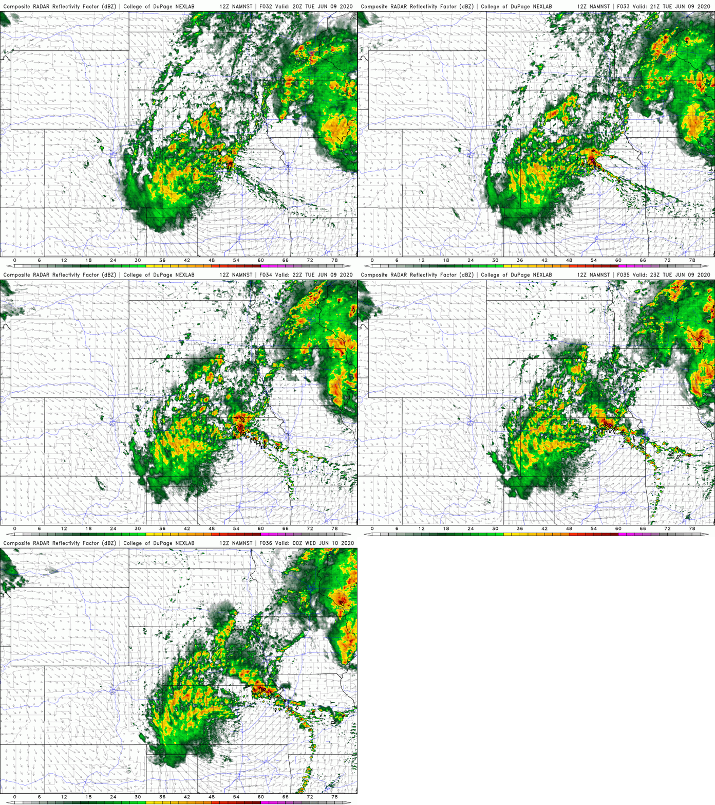
Currently the SPC seems to be favoring the 3km NAM which has much of the storms in northeast KS. However, the 12z HRRR and HRRRv4 both have storms in our area (further north). These storms will likely be severe and possibly tornadic - especially if they are isolated. If not, the southeasterly most storm will have the greatest tornado potential. Most likely storms will simply be too close to each other and consequently tornado potential will be decreased (though tornado potential will be highest when storms first develop but eventually there will probably be too many of them). Chances are it will be more of a hail event with an isolated tornado or 2 in the area (possibly rain wrapped tornado potential) - mostly south of Omaha though but close enough people need to pay close attention.
SPC outlook for tomorrow (don't be surprised if this is pushed north some on the next update):
12z HRRR showing storms forming between 3PM and 6PM from near Omaha on south with the warm front very close to town (which is often the focus for tornadoes):
12z HRRRv4 showing storms again forming between 3PM and 6PM (again from Omaha on south with the warm front very close by):
...and finally the 3km NAM which is what the SPC has been favoring at least up to now (further south and seems to be the outlier at this point):
Currently the SPC seems to be favoring the 3km NAM which has much of the storms in northeast KS. However, the 12z HRRR and HRRRv4 both have storms in our area (further north). These storms will likely be severe and possibly tornadic - especially if they are isolated. If not, the southeasterly most storm will have the greatest tornado potential. Most likely storms will simply be too close to each other and consequently tornado potential will be decreased (though tornado potential will be highest when storms first develop but eventually there will probably be too many of them). Chances are it will be more of a hail event with an isolated tornado or 2 in the area (possibly rain wrapped tornado potential) - mostly south of Omaha though but close enough people need to pay close attention.
SPC outlook for tomorrow (don't be surprised if this is pushed north some on the next update):
12z HRRR showing storms forming between 3PM and 6PM from near Omaha on south with the warm front very close to town (which is often the focus for tornadoes):
12z HRRRv4 showing storms again forming between 3PM and 6PM (again from Omaha on south with the warm front very close by):
...and finally the 3km NAM which is what the SPC has been favoring at least up to now (further south and seems to be the outlier at this point):
-
NUub
- Library Board
- Posts: 331
- Joined: Mon May 18, 2020 2:58 am
Re: 2020 Severe Weather Thread
Is that HRRR model a newer product? The NAM is established and all, but the visual forecast is beautiful. Is it run on a 12hr interval?
-
stormchaser
- Planning Board
- Posts: 2380
- Joined: Fri Jun 01, 2018 1:14 pm
Re: 2020 Severe Weather Thread
The HRRR itself has been around for a while now but the HRRRv4 is very new. The HRRR itself updates hourly (which makes it nice for nowcasting and short range forecasting obviously) but it's limited in how far you can see out (only 18 hours except for the 06z, 12z, 18z and 00z runs which allows you to see up to 36 hours). The HRRRv4 updates only at 06z, 12z, 18z and 00z but it allows you to use it to see up to 48 hours out. The 3km NAM is a newer product also. It updates at 06z, 12z, 18z and 00z.NUub wrote: Mon Jun 08, 2020 5:01 pm Is that HRRR model a newer product? The NAM is established and all, but the visual forecast is beautiful. Is it run on a 12hr interval?
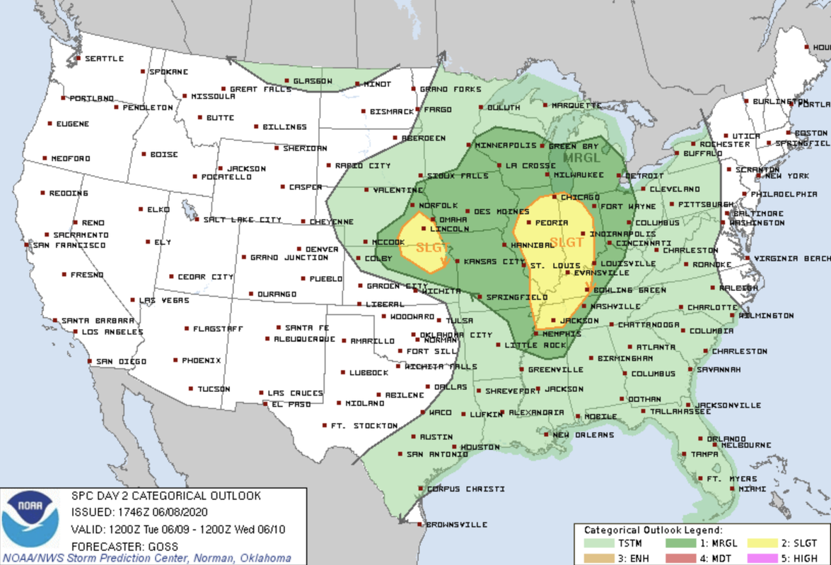
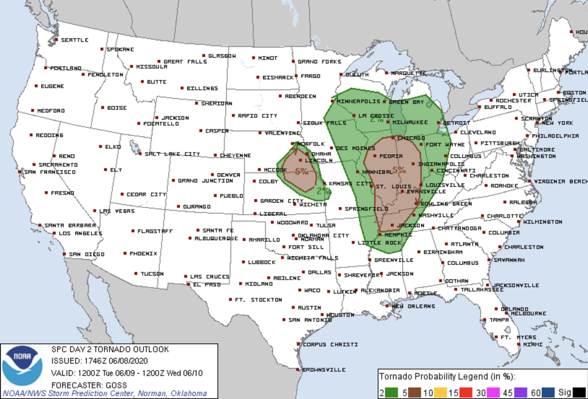
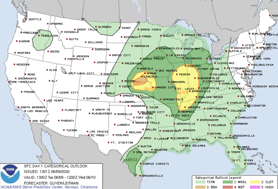
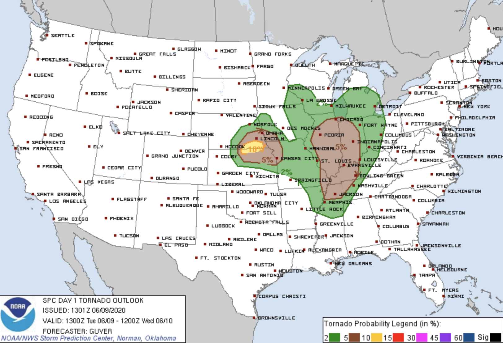
SPC updated and as expected shifted things north some - and increased the tornado risk for tomorrow (up to 5% now which is up from the 2% earlier).
Here is the updated SPC outlook for tomorrow:
SPC tornado risk for tomorrow:
-
Uffda

- County Board
- Posts: 4624
- Joined: Mon Jun 13, 2005 2:52 am
- Location: Land o Lakes, FL
Re: 2020 Severe Weather Thread
If you are heading west on I-80 Tonight into tomorrow ---
The National Weather Service in Cheyenne has issued a Winter Weather Advisory for portions of Laramie County between Cheyenne and Laramie.
The advisory is set to begin at 6 PM MDT this evening until 12 PM MDT Tuesday. According to the NWS, the expected total snow accumulations is expected to be 3 to 6 inches with locally higher amounts possible.
Winds gusting as high as 50 MPH. Wind chills in the teens are possible..
The National Weather Service in Cheyenne has issued a Winter Weather Advisory for portions of Laramie County between Cheyenne and Laramie.
The advisory is set to begin at 6 PM MDT this evening until 12 PM MDT Tuesday. According to the NWS, the expected total snow accumulations is expected to be 3 to 6 inches with locally higher amounts possible.
Winds gusting as high as 50 MPH. Wind chills in the teens are possible..
We are the people our parents warned us about.
Jimmy Buffett
Jimmy Buffett
-
Uffda
- County Board
- Posts: 4624
- Joined: Mon Jun 13, 2005 2:52 am
- Location: Land o Lakes, FL
Re: 2020 Severe Weather Thread
Didn't hit NE but Derocho --- Utah into North Dakota
Satellite video
Satellite video
We are the people our parents warned us about.
Jimmy Buffett
Jimmy Buffett
-
stormchaser
- Planning Board
- Posts: 2380
- Joined: Fri Jun 01, 2018 1:14 pm
Re: 2020 Severe Weather Thread
Confirmed tornado out near North Platte currently. Likely going to be several in that area up into North Central NE over the next few hours...
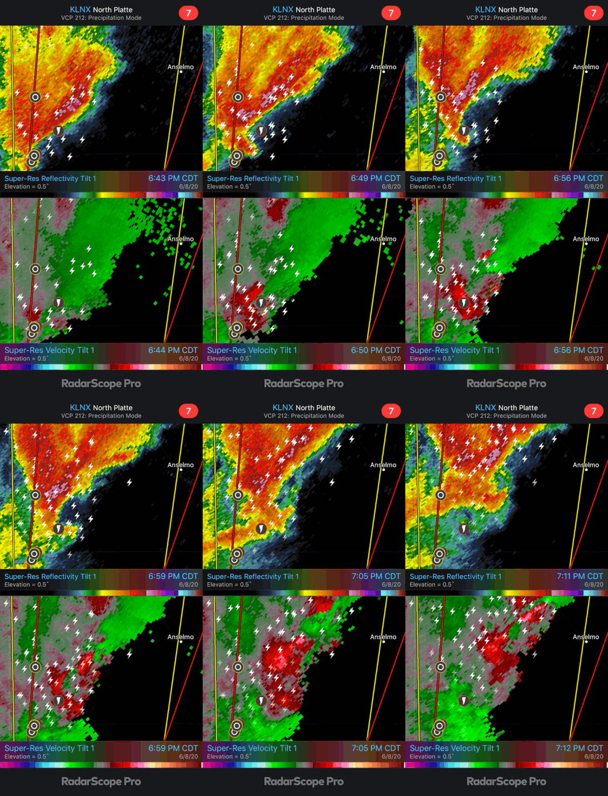
Tomorrow continues to look potentially dangerous in our area - possibly very close to Lincoln and Omaha. I hope people pay close attention.
Tomorrow continues to look potentially dangerous in our area - possibly very close to Lincoln and Omaha. I hope people pay close attention.
-
Omaha Cowboy
- The Don
- Posts: 1013737
- Joined: Wed Jan 07, 2004 11:31 am
- Location: West Omaha
Re: 2020 Severe Weather Thread
I’ve heard possible winds clocking up to 65 mph out of the NW sometime after 6pm tomorrow in the Omaha area..with severe thunderstorms, possible hail and some heavy rain.. Keep your phones, iPads and laptops charged up because there could be some widespread power outages with these wind gusts..stormchaser wrote: Tue Jun 09, 2020 12:18 am Confirmed tornado out near North Platte currently. Likely going to be several in that area up into North Central NE over the next few hours...
Tomorrow continues to look potentially dangerous in our area - possibly very close to Lincoln and Omaha. I hope people pay close attention.
Thank you very much for your updates
...Ciao..LiO...Peace
Go Cowboys!
-
Busguy2010
- City Council
- Posts: 7393
- Joined: Sun Apr 10, 2011 12:32 am
- Location: North Central Omaha
Re: 2020 Severe Weather Thread
Gonna be a weird day, it appears. I don't recall ever having a tropical system clash with a domestic system pretty much directly over us.
-
stormchaser
- Planning Board
- Posts: 2380
- Joined: Fri Jun 01, 2018 1:14 pm
Re: 2020 Severe Weather Thread
Risk increased to an enhanced risk from near Lincoln on south/southwest where the tornado risk has also been increased to 10%.
Latest HRRR showing what would be the strongest storm/main tornado, hail, damaging wind threat forming around 4PM southwest of Lincoln and riding the boundary up into the Omaha area. Probably will be mostly a damaging wind and hail threat by the time it makes it to Omaha though...
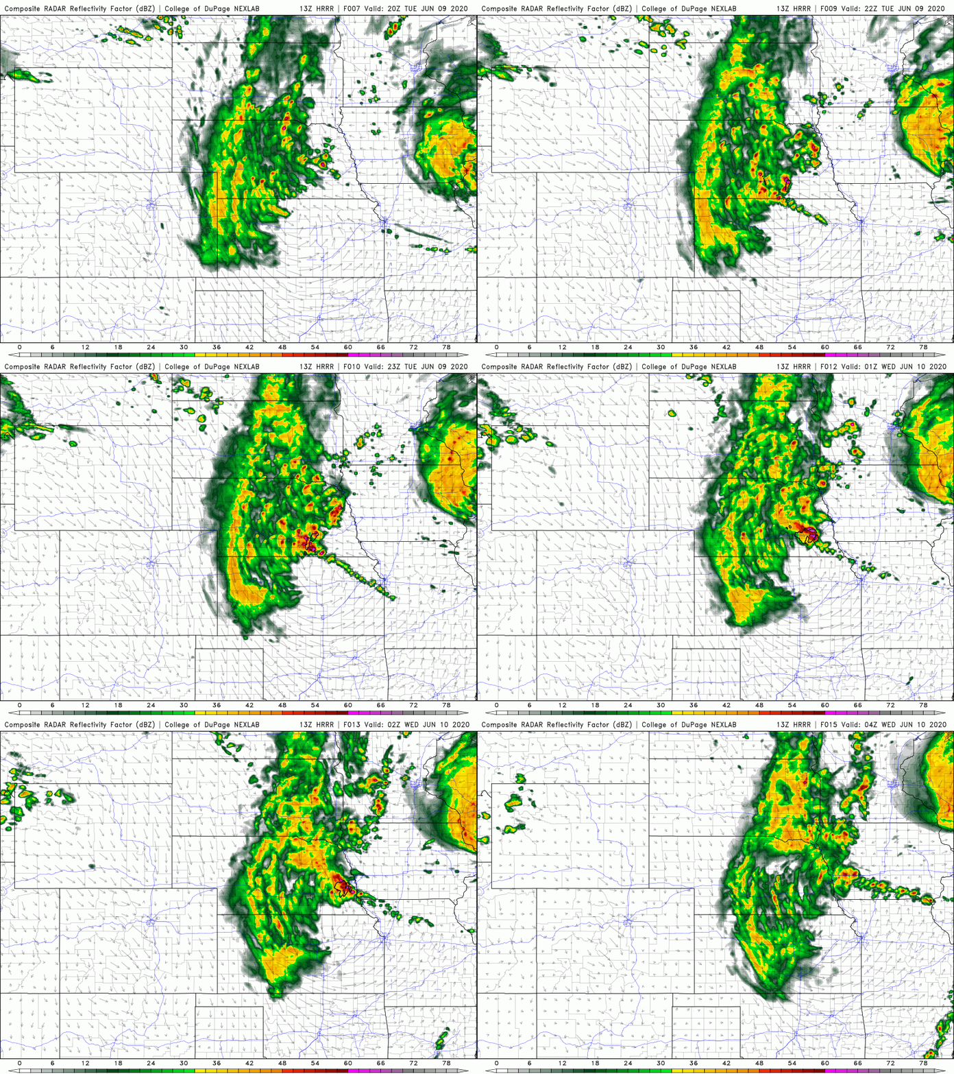
Latest HRRR showing what would be the strongest storm/main tornado, hail, damaging wind threat forming around 4PM southwest of Lincoln and riding the boundary up into the Omaha area. Probably will be mostly a damaging wind and hail threat by the time it makes it to Omaha though...
-
stormchaser
- Planning Board
- Posts: 2380
- Joined: Fri Jun 01, 2018 1:14 pm
Re: 2020 Severe Weather Thread
My prediction for today (though obviously it's just my opinion, nothing official).
A tornadic storm will develop sometime around 4PM in the Hebron or Fairbury Nebraska area (or adjacent parts of northern KS - very close to the border though). This storm will move northeast and produce multiple tornadoes in the Wilber area (roughly) and areas between Linclon/Beatrice. The torandic part of the storm should move south/southeast of Lincoln with large damaging hail and wind moving through Lincoln itself and following along the interstate up towards Omaha. Eventually additional storms will develop east/southeast of the main tornado producing storm killing off most of the tornado potential and consequently causing the storm to grow more "upscale" into more of a QLCS or a linear mode. The south side of Omaha in particular will probably be impacted by damaging wind/hail sometime near or after 7PM. In addition, very heavy rain with potential flooding should be expected in the Lincoln and Omaha area this evening and into the overnight hours.
It's worth noting additional damaging hail may pass just west and north of Omaha around 5ish also (it's close enough people in Omaha need to keep an eye on it). If it pushes through Omaha itself, that would push the later round of storms further south and Omaha would be spared.
A tornadic storm will develop sometime around 4PM in the Hebron or Fairbury Nebraska area (or adjacent parts of northern KS - very close to the border though). This storm will move northeast and produce multiple tornadoes in the Wilber area (roughly) and areas between Linclon/Beatrice. The torandic part of the storm should move south/southeast of Lincoln with large damaging hail and wind moving through Lincoln itself and following along the interstate up towards Omaha. Eventually additional storms will develop east/southeast of the main tornado producing storm killing off most of the tornado potential and consequently causing the storm to grow more "upscale" into more of a QLCS or a linear mode. The south side of Omaha in particular will probably be impacted by damaging wind/hail sometime near or after 7PM. In addition, very heavy rain with potential flooding should be expected in the Lincoln and Omaha area this evening and into the overnight hours.
It's worth noting additional damaging hail may pass just west and north of Omaha around 5ish also (it's close enough people in Omaha need to keep an eye on it). If it pushes through Omaha itself, that would push the later round of storms further south and Omaha would be spared.
-
Busguy2010
- City Council
- Posts: 7393
- Joined: Sun Apr 10, 2011 12:32 am
- Location: North Central Omaha
Re: 2020 Severe Weather Thread
Tornado watch 2020 #1 in effect until 10pm.
-
Omaha Cowboy
- The Don
- Posts: 1013737
- Joined: Wed Jan 07, 2004 11:31 am
- Location: West Omaha
Re: 2020 Severe Weather Thread
Quite a storm yesterday. Lost power at my residence for 2 hours yesterday evening.. Thankfully they were above to restore around 9:30pm...
Ciao..LiO...Peace
Ciao..LiO...Peace
Go Cowboys!
-
stormchaser
- Planning Board
- Posts: 2380
- Joined: Fri Jun 01, 2018 1:14 pm
Re: 2020 Severe Weather Thread
Yep, we lost power in the Millard area also (not sure for how long as we were out chasing and came home to find no power). Looks like my forecast played out decently well though timing was a bit off...Omaha Cowboy wrote: Wed Jun 10, 2020 12:26 pm Quite a storm yesterday. Lost power at my residence for 2 hours yesterday evening.. Thankfully they were above to restore around 9:30pm...
Ciao..LiO...Peace
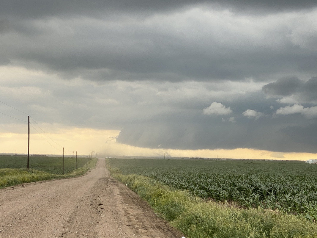
Ended up being down in the Fairbury area when the first tornado warning was issued. This was reported as a tornado but I'm fairly confident it was more of a "gustnado" than an actual tornado (but maybe it was just a dusty tornado too, hard to say for sure but no obvious funnel from our view anyway).
-
damonhynes
- Parks & Recreation
- Posts: 1282
- Joined: Wed Aug 27, 2014 12:35 am
- Location: Montgomery County, Texas
Re: 2020 Severe Weather Thread
Clay Osterly from Ch. 6 showed some vid that he'd shot from Fairbury, looked like RFD to me.stormchaser wrote: Wed Jun 10, 2020 1:30 pmYep, we lost power in the Millard area also (not sure for how long as we were out chasing and came home to find no power). Looks like my forecast played out decently well though timing was a bit off...Omaha Cowboy wrote: Wed Jun 10, 2020 12:26 pm Quite a storm yesterday. Lost power at my residence for 2 hours yesterday evening.. Thankfully they were above to restore around 9:30pm...
Ciao..LiO...Peace
Ended up being down in the Fairbury area when the first tornado warning was issued. This was reported as a tornado but I'm fairly confident it was more of a "gustnado" than an actual tornado (but maybe it was just a dusty tornado too, hard to say for sure but no obvious funnel from our view anyway).
-
stormchaser
- Planning Board
- Posts: 2380
- Joined: Fri Jun 01, 2018 1:14 pm
Re: 2020 Severe Weather Thread
Yeah, could be - either way the crashing cold front in the area didn't help things (for anyone wanting to see a tornado anyway)...damonhynes wrote: Wed Jun 10, 2020 1:35 pmClay Osterly from Ch. 6 showed some vid that he'd shot from Fairbury, looked like RFD to me.stormchaser wrote: Wed Jun 10, 2020 1:30 pmYep, we lost power in the Millard area also (not sure for how long as we were out chasing and came home to find no power). Looks like my forecast played out decently well though timing was a bit off...Omaha Cowboy wrote: Wed Jun 10, 2020 12:26 pm Quite a storm yesterday. Lost power at my residence for 2 hours yesterday evening.. Thankfully they were above to restore around 9:30pm...
Ciao..LiO...Peace
Ended up being down in the Fairbury area when the first tornado warning was issued. This was reported as a tornado but I'm fairly confident it was more of a "gustnado" than an actual tornado (but maybe it was just a dusty tornado too, hard to say for sure but no obvious funnel from our view anyway).
-
Omaha Cowboy
- The Don
- Posts: 1013737
- Joined: Wed Jan 07, 2004 11:31 am
- Location: West Omaha
Re: 2020 Severe Weather Thread
That kind of looks like a funnel and tornado touchdown to my untrained eye..damonhynes wrote: Wed Jun 10, 2020 1:35 pmClay Osterly from Ch. 6 showed some vid that he'd shot from Fairbury, looked like RFD to me.stormchaser wrote: Wed Jun 10, 2020 1:30 pmYep, we lost power in the Millard area also (not sure for how long as we were out chasing and came home to find no power). Looks like my forecast played out decently well though timing was a bit off...Omaha Cowboy wrote: Wed Jun 10, 2020 12:26 pm Quite a storm yesterday. Lost power at my residence for 2 hours yesterday evening.. Thankfully they were above to restore around 9:30pm...
Ciao..LiO...Peace
Ended up being down in the Fairbury area when the first tornado warning was issued. This was reported as a tornado but I'm fairly confident it was more of a "gustnado" than an actual tornado (but maybe it was just a dusty tornado too, hard to say for sure but no obvious funnel from our view anyway).
Great Pic stormchaser!...
Ciao..LiO...Peace
Go Cowboys!
-
stormchaser
- Planning Board
- Posts: 2380
- Joined: Fri Jun 01, 2018 1:14 pm
Re: 2020 Severe Weather Thread
Thanks Omaha Cowboy!Omaha Cowboy wrote: Wed Jun 10, 2020 3:41 pm That kind of looks like a funnel and tornado touchdown to my untrained eye..
Great Pic stormchaser!...
Ciao..LiO...Peace