We are headed to Wisconsin for the next week maybe a little longer, only going to be in the upper 70's and lower 80's.
I actually wouldn't mind being in Omaha for the heat spell since we have a pool in our backyard and that makes the summer so much more bearable.
I just hope that my garden and lawn don't all burn up while we are gone.
2021 Weather thread-
-
skinzfan23
- City Council
- Posts: 11672
- Joined: Mon Feb 09, 2004 5:26 pm
- Location: Omaha/Bellevue
-
Busguy2010

- City Council
- Posts: 7397
- Joined: Sun Apr 10, 2011 12:32 am
- Location: North Central Omaha
Re: 2021 Weather thread-
I'm just glad to know that astronomically we are on the downhill side. Before too long, we should be seeing more 70s and 80s, then 60's. Should be able to visibly see the shadows getting longer over the next couple weeks. I'll just be trying to block this stretch out. When it's this hot outside, there's not much worth going outside for, much like on the other end of the spectrum when it is 15 degrees.
-
Cermak
- Planning Board
- Posts: 2349
- Joined: Thu Nov 29, 2018 7:02 pm
Re: 2021 Weather thread-
Seems like every summer we get one of these, usually at this time of the year. If you want to be outside you pretty much need to do it before 10am or after 8pm.
-
Busguy2010
- City Council
- Posts: 7397
- Joined: Sun Apr 10, 2011 12:32 am
- Location: North Central Omaha
Re: 2021 Weather thread-
Tomorrow actually won't be half bad for 96 because the dew point is supposed to be 59. It will actually feel like 96. Still not good, but you gotta take what little we will get this week. Monday looks not terrible, Tuesday looks awful, Wednesday looks even worse, Thursday looks bad, then Friday looks like we break the heat.
-
GetUrban
- Planning Board
- Posts: 2650
- Joined: Sun Nov 23, 2008 9:07 pm
- Location: Omaha
Re: 2021 Weather thread-
Dew point is still 70 degrees right now. 59 would be great, but I don’t think we’ll see that soon.Busguy2010 wrote: Sat Jul 24, 2021 4:08 pm Tomorrow actually won't be half bad for 96 because the dew point is supposed to be 59. It will actually feel like 96. Still not good, but you gotta take what little we will get this week. Monday looks not terrible, Tuesday looks awful, Wednesday looks even worse, Thursday looks bad, then Friday looks like we break the heat.
He said "They are some big, ugly red brick buildings"
...and then they were gone.
...and then they were gone.
-
Busguy2010
- City Council
- Posts: 7397
- Joined: Sun Apr 10, 2011 12:32 am
- Location: North Central Omaha
Re: 2021 Weather thread-
No really, it's supposed to be 59 around 5pm. Short lived, unfortunately, but we take what we can get. 59 is pretty good any time during the summer, let alone this miserable stretch. But yes, outside right now it is super muggy.GetUrban wrote: Sun Jul 25, 2021 2:35 pmDew point is still 70 degrees right now. 59 would be great, but I don’t think we’ll see that soon.Busguy2010 wrote: Sat Jul 24, 2021 4:08 pm Tomorrow actually won't be half bad for 96 because the dew point is supposed to be 59. It will actually feel like 96. Still not good, but you gotta take what little we will get this week. Monday looks not terrible, Tuesday looks awful, Wednesday looks even worse, Thursday looks bad, then Friday looks like we break the heat.
-
Brad

- Photographer
- Posts: 1036702
- Joined: Sun Feb 29, 2004 12:03 am
- Location: Omaha, NE
Re: 2021 Weather thread-
Areas along the Nebraska / Kansas border got ton of rain last night. Radar estimating 5+ inches in some areas.

Omaha Skyline Photos, Omaha Aerial Photos, and More.
Website: www.bradwilliamsphotography.com
Facebook: www.facebook.com/bradwilliamsphotography
Twitter: www.twitter.com/bradwphoto
Instagram: www.instagram.com/bradwilliamsphotography
YouTube: www.youtube.com/@bradwilliamsphoto
-
jag42
- Human Relations
- Posts: 546
- Joined: Sat Mar 14, 2009 6:29 pm
- Location: Omaha Metro Area
Re: 2021 Weather thread-
Article in today's O W-H about the windstorm a couple weeks ago:
https://omaha.com/weather/windstorm-cut ... 1E_GbRQ64g
https://omaha.com/weather/windstorm-cut ... 1E_GbRQ64g
-
Omaha Cowboy

- The Don
- Posts: 1013739
- Joined: Wed Jan 07, 2004 11:31 am
- Location: West Omaha
Re: 2021 Weather thread-
Decent day out today..
I guess the real heat starts pouring in Monday and most of next week…
Ciao..LiO…Peace
I guess the real heat starts pouring in Monday and most of next week…
Ciao..LiO…Peace
Go Cowboys!
-
Brad
- Photographer
- Posts: 1036702
- Joined: Sun Feb 29, 2004 12:03 am
- Location: Omaha, NE
Re: 2021 Weather thread-
Here's a map from this mornings crazy rain.
Omaha Skyline Photos, Omaha Aerial Photos, and More.
Website: www.bradwilliamsphotography.com
Facebook: www.facebook.com/bradwilliamsphotography
Twitter: www.twitter.com/bradwphoto
Instagram: www.instagram.com/bradwilliamsphotography
YouTube: www.youtube.com/@bradwilliamsphoto
-
Busguy2010
- City Council
- Posts: 7397
- Joined: Sun Apr 10, 2011 12:32 am
- Location: North Central Omaha
Re: 2021 Weather thread-
I saw some pretty large, red, mostly stationary storms on the radar that day down there.
The dew point is supposed to be 73 tomorrow, so as the temperature is supposed to be 98, the heat index is going to be almost 110, while Wednesday is supposed to be 102-104 with the heat index also of about 110. Nasty stretch here. At least the high for today might not be as hot as was predicted earlier in the forecast.
The dew point is supposed to be 73 tomorrow, so as the temperature is supposed to be 98, the heat index is going to be almost 110, while Wednesday is supposed to be 102-104 with the heat index also of about 110. Nasty stretch here. At least the high for today might not be as hot as was predicted earlier in the forecast.
-
Busguy2010
- City Council
- Posts: 7397
- Joined: Sun Apr 10, 2011 12:32 am
- Location: North Central Omaha
Re: 2021 Weather thread-
Wow, heat advisory is on all day, over night, and doesn't end until 9pm tomorrow. Usually they end at 8pm and also usually end over night and are usually only a 12pm to 8pm type of deal. We hold a heat index until 4am and that is pretty much as early as it gets below 80 degrees. Just love this weather.
I was just daydreaming hard that it was cloudy, raining, and about 45 degrees. I wish somehow the season's would be flipped, with the short days being the hot, miserable days, and the long days being tolerably cool. Wouldn't that be perfect. Ahh, I'm in for a rude awakening.
I was just daydreaming hard that it was cloudy, raining, and about 45 degrees. I wish somehow the season's would be flipped, with the short days being the hot, miserable days, and the long days being tolerably cool. Wouldn't that be perfect. Ahh, I'm in for a rude awakening.
-
Busguy2010
- City Council
- Posts: 7397
- Joined: Sun Apr 10, 2011 12:32 am
- Location: North Central Omaha
Re: 2021 Weather thread-
Okay, there's a decent (when I say decent, I mean it in the least sense) rain chance to end the month, so I have no doubt we end July with yet another month with an official moisture deficit, and that is despite the NWS lowering the "normal" precipitation numbers.
Haven't crunched the numbers yet, and I will do so at the end of the month, but it appears - despite not having a surplus month since March- we may still be ahead in moisture on the year, thanks to our snowy and wet start to the year. Not that that does us any good now.
Been 12 days with no rain so far. Will be happy to see a little precipitation and cooler temperatures. Also am happy to soon be flipping the calendar to August. That is always a symbolic moment for me, because that typically means only about a month and a half of potential hot weather. I feel like fall could be just around the corner, or am I just getting desperate?
Haven't crunched the numbers yet, and I will do so at the end of the month, but it appears - despite not having a surplus month since March- we may still be ahead in moisture on the year, thanks to our snowy and wet start to the year. Not that that does us any good now.
Been 12 days with no rain so far. Will be happy to see a little precipitation and cooler temperatures. Also am happy to soon be flipping the calendar to August. That is always a symbolic moment for me, because that typically means only about a month and a half of potential hot weather. I feel like fall could be just around the corner, or am I just getting desperate?
-
stormchaser
- Planning Board
- Posts: 2380
- Joined: Fri Jun 01, 2018 1:14 pm
Re: 2021 Weather thread-
Looking like a chance of severe weather in the area this coming Friday (July 30th) based on the 12z NAM.
Depicted forecast soundings show the potential for supercells/tornadoes but lots of uncertainty including exactly where the boundary sets up (right now it's shown right along I-80 including in the Omaha area), how quickly the boundary starts crashing south as a cold front (which means storms would become undercut/outflow dominant and consequently become more wind producers) and how much convection ends up being in the area that may stabilize the atmosphere in the area (which would greatly decrease potential).
Either way, some areas will probably get heavy rain if nothing else anyway - but I'd assume at least some severe weather unless things change between now and then. Something to keep an eye on anyway...
Included sounding is mostly to show the wind profiles/hodograph in the Omaha area for 00z which shows a favorable environment for supercells/potential tornadic storms...
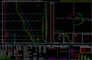
Depicted forecast soundings show the potential for supercells/tornadoes but lots of uncertainty including exactly where the boundary sets up (right now it's shown right along I-80 including in the Omaha area), how quickly the boundary starts crashing south as a cold front (which means storms would become undercut/outflow dominant and consequently become more wind producers) and how much convection ends up being in the area that may stabilize the atmosphere in the area (which would greatly decrease potential).
Either way, some areas will probably get heavy rain if nothing else anyway - but I'd assume at least some severe weather unless things change between now and then. Something to keep an eye on anyway...
Included sounding is mostly to show the wind profiles/hodograph in the Omaha area for 00z which shows a favorable environment for supercells/potential tornadic storms...
-
Busguy2010
- City Council
- Posts: 7397
- Joined: Sun Apr 10, 2011 12:32 am
- Location: North Central Omaha
Re: 2021 Weather thread-
Yet another overnight chance though. This season has been so frustrating in that regard. I think we only had one substantial-ish storm occurr during the day and that was the one a couple weeks ago on the Saturday after that freak storm.
-
stormchaser
- Planning Board
- Posts: 2380
- Joined: Fri Jun 01, 2018 1:14 pm
Re: 2021 Weather thread-
It has been frustrating/disappointing in that regard. In this particular case, there "might" be daytime storms for a change though in the area with the predominant chance of rain/potential heavy rain occurring near or after dark though (the daytime stuff would be more isolated in nature which would also be more conducive for potential supercells - if things play out as shown currently anyway).Busguy2010 wrote: Wed Jul 28, 2021 4:11 pm Yet another overnight chance though. This season has been so frustrating in that regard. I think we only had one substantial-ish storm occurr during the day and that was the one a couple weeks ago on the Saturday after that freak storm.
-
Busguy2010
- City Council
- Posts: 7397
- Joined: Sun Apr 10, 2011 12:32 am
- Location: North Central Omaha
Re: 2021 Weather thread-
Oh yeah I guess so. I should have looked farther ahead than just Friday early AM. The chance gradually goes up to a peak of 70% on Saturday early AM, so maybe we could see something Friday during the day. I won't bet on it though.
-
stormchaser
- Planning Board
- Posts: 2380
- Joined: Fri Jun 01, 2018 1:14 pm
Re: 2021 Weather thread-
Probably not - and for reference, the SPC is saying elevated storms with mostly a risk for marginal severe wind/hail. Only time will tell thoughBusguy2010 wrote: Wed Jul 28, 2021 4:35 pm Oh yeah I guess so. I should have looked farther ahead than just Friday early AM. The chance gradually goes up to a peak of 70% on Saturday early AM, so maybe we could see something Friday during the day. I won't bet on it though.

-
stormchaser
- Planning Board
- Posts: 2380
- Joined: Fri Jun 01, 2018 1:14 pm
Re: 2021 Weather thread-
Some chance for storms today just south of Omaha along an east/west boundary in that area. Low risk for a strong/severe storm or 2 mostly for hail with these storms (mostly from near York to Nebraska City roughly).
Another round of storms is possible in Omaha tomorrow morning (Friday, July 30) based on short-range model guidance. Again, the potential for a marginally strong/severe storm with isolated damaging wind/hail being the main threat though the threat should be pretty brief but it might be just in time for the morning commute.
Otherwise, tomorrow night (mostly after midnight) is when the main heavy rain event will occur in the area. Some places will probably get 1"-2"+ of rainfall in eastern NE (including possibly in Omaha depending on where the boundary ends up).
The threat for severe weather/potential supercells/tornadoes has decreased for tomorrow as capping will probably hold strong throughout the day in the area along and south of the boundary (which would be the favorable environment). If the cap breaks it could be interesting but right now that doesn't look to be the case. Some chance with the nighttime storms for some damaging hail in the area again though in addition to the heavy rain (should be pretty isolated if it happens though).
Another round of storms is possible in Omaha tomorrow morning (Friday, July 30) based on short-range model guidance. Again, the potential for a marginally strong/severe storm with isolated damaging wind/hail being the main threat though the threat should be pretty brief but it might be just in time for the morning commute.
Otherwise, tomorrow night (mostly after midnight) is when the main heavy rain event will occur in the area. Some places will probably get 1"-2"+ of rainfall in eastern NE (including possibly in Omaha depending on where the boundary ends up).
The threat for severe weather/potential supercells/tornadoes has decreased for tomorrow as capping will probably hold strong throughout the day in the area along and south of the boundary (which would be the favorable environment). If the cap breaks it could be interesting but right now that doesn't look to be the case. Some chance with the nighttime storms for some damaging hail in the area again though in addition to the heavy rain (should be pretty isolated if it happens though).
-
Busguy2010
- City Council
- Posts: 7397
- Joined: Sun Apr 10, 2011 12:32 am
- Location: North Central Omaha
Re: 2021 Weather thread-
Wow, the NWS is talking about 2" of rain to fall in just a few hours on very early Saturday morning. I wonder what that storm will look like. In that event, we would definitely hit our moisture level for the month of July. They weren't talking nearly that much the other day when I said we would likely end July with a deficit.
Just gotta get through today with the miserable heat and humidity, and it looks like we are in for some comfortable weather for the entire upcoming forecast period.
Just gotta get through today with the miserable heat and humidity, and it looks like we are in for some comfortable weather for the entire upcoming forecast period.
Last edited by Busguy2010 on Thu Jul 29, 2021 6:01 pm, edited 2 times in total.
-
stormchaser
- Planning Board
- Posts: 2380
- Joined: Fri Jun 01, 2018 1:14 pm
Re: 2021 Weather thread-
Yep, it will be interesting depending on exactly where that boundary sets up with storms training over the same areas for a period of time.Busguy2010 wrote: Thu Jul 29, 2021 5:28 pm Wow, the NWS is talking about 2" of rain to fall in just a few hours on very early Saturday morning. I wonder what that storm will look like.
Just gotta get through today with the miserable heat and humidity, and it looks like we are in for some comfortable weather for the entire upcoming forecast period.
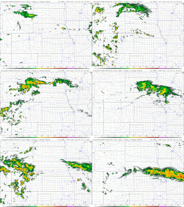
Here is an animation (based on the 12z HRRR forecast model) showing the simulated radar from now until late tomorrow night. You can see the Friday night storms develop toward the end of the animation (developing around Midnight and moving into the area).
-
Busguy2010
- City Council
- Posts: 7397
- Joined: Sun Apr 10, 2011 12:32 am
- Location: North Central Omaha
Re: 2021 Weather thread-
They have elevated us to slight risk for day 2 (tomorrow). Assuming the main risk is the storm that is supposed to come through right around midnight Saturday. If the rain holds together and it were to happen in one single day, we would have been in record rainfall territory. Of course, it is supposed to partly occur on Friday, so probably won't get quite 2" of rain on Saturday.
And I do believe the today and yesterday have easily been the most uncomfortable days of the year. We had the one day last month that it was 105, but I don't think the heat index was so high due to a lower dew point. Dew point has been flirting with 80 last couple days, should be plenty of fuel for the thunderstorms tomorrow night. Will be so thankful when the prospects of this hot and sticky weather are nil.
And I do believe the today and yesterday have easily been the most uncomfortable days of the year. We had the one day last month that it was 105, but I don't think the heat index was so high due to a lower dew point. Dew point has been flirting with 80 last couple days, should be plenty of fuel for the thunderstorms tomorrow night. Will be so thankful when the prospects of this hot and sticky weather are nil.
-
stormchaser
- Planning Board
- Posts: 2380
- Joined: Fri Jun 01, 2018 1:14 pm
Re: 2021 Weather thread-
The morning storms have developed in the Omaha area. Nothing severe warned as of yet but definitely a fairly strong storm currently (as of 6:30am as I’m posting this).
Odds continue to increase for some severe weather in the area later today with the SPC expanding the day 1 outlook to cover a larger area (with Omaha near the center). Damaging wind and hail will be the primary threat though isolated tornadoes are possible too.
In Omaha itself, most of the severe potential will probably occur this evening (after 6pm) as storms will develop northwest of here and eventually move southeast into our area.
It’s worth noting, the latest short range models are showing a damaging hail event in the Omaha area this evening. It’s of course difficult to know if it will happen exactly as shown and if Omaha itself will get hit…but it’s something to be mindful of anyway.
Odds continue to increase for some severe weather in the area later today with the SPC expanding the day 1 outlook to cover a larger area (with Omaha near the center). Damaging wind and hail will be the primary threat though isolated tornadoes are possible too.
In Omaha itself, most of the severe potential will probably occur this evening (after 6pm) as storms will develop northwest of here and eventually move southeast into our area.
It’s worth noting, the latest short range models are showing a damaging hail event in the Omaha area this evening. It’s of course difficult to know if it will happen exactly as shown and if Omaha itself will get hit…but it’s something to be mindful of anyway.
-
Busguy2010
- City Council
- Posts: 7397
- Joined: Sun Apr 10, 2011 12:32 am
- Location: North Central Omaha
Re: 2021 Weather thread-
That one this morning sure turned out a lot heavier than I expected. I was asleep during the storm, but it obviously influenced my dream, as I dreamt it hailed bowling ball size stones. Whatever happens tonight, I hope it is fairly tame. After that last one, I'm a bit shy.
Since we got almost a half inch of rain this morning, does look like we have a chance for a record precipitation day today. Would need about 1.3" by midnight and sounds like the storm will easily deliver that much, just depends on timing. Current record of 1.71" has stood since 1958.
Since we got almost a half inch of rain this morning, does look like we have a chance for a record precipitation day today. Would need about 1.3" by midnight and sounds like the storm will easily deliver that much, just depends on timing. Current record of 1.71" has stood since 1958.
-
Brad
- Photographer
- Posts: 1036702
- Joined: Sun Feb 29, 2004 12:03 am
- Location: Omaha, NE
Re: 2021 Weather thread-
Most parts of town go nothing.Busguy2010 wrote: Fri Jul 30, 2021 3:19 pm That one this morning sure turned out a lot heavier than I expected.
Omaha Skyline Photos, Omaha Aerial Photos, and More.
Website: www.bradwilliamsphotography.com
Facebook: www.facebook.com/bradwilliamsphotography
Twitter: www.twitter.com/bradwphoto
Instagram: www.instagram.com/bradwilliamsphotography
YouTube: www.youtube.com/@bradwilliamsphoto
-
Busguy2010
- City Council
- Posts: 7397
- Joined: Sun Apr 10, 2011 12:32 am
- Location: North Central Omaha
Re: 2021 Weather thread-
The airport got a half inch and in North Central it was pouring for a good 20 min. Pretty good amount of thunder too. I didn't see the radar though.Brad wrote: Fri Jul 30, 2021 3:26 pmMost parts of town go nothing.Busguy2010 wrote: Fri Jul 30, 2021 3:19 pm That one this morning sure turned out a lot heavier than I expected.
-
Brad
- Photographer
- Posts: 1036702
- Joined: Sun Feb 29, 2004 12:03 am
- Location: Omaha, NE
Re: 2021 Weather thread-
I didn't do a screen capture this morning, but here is one Rusty tweted. The storms kept moving in the same direction so northing west or south of that line got wet.
Omaha Skyline Photos, Omaha Aerial Photos, and More.
Website: www.bradwilliamsphotography.com
Facebook: www.facebook.com/bradwilliamsphotography
Twitter: www.twitter.com/bradwphoto
Instagram: www.instagram.com/bradwilliamsphotography
YouTube: www.youtube.com/@bradwilliamsphoto
-
Busguy2010
- City Council
- Posts: 7397
- Joined: Sun Apr 10, 2011 12:32 am
- Location: North Central Omaha
Re: 2021 Weather thread-
So it sounds like the greater tornado and hail threat is just to our northwest when storms will be young and isolated. Then as they conglomerate, those risks go down with damaging wind threat going up. This gives me flashbacks of that last one. Same time, same day, same threat, coming from the same direction.
-
Louie
- County Board
- Posts: 4968
- Joined: Fri Dec 23, 2011 10:23 pm
- Location: Dundee
Re: 2021 Weather thread-
The smoke in the air today is wild...
-
stormchaser
- Planning Board
- Posts: 2380
- Joined: Fri Jun 01, 2018 1:14 pm
Re: 2021 Weather thread-
Yep, looking that wayBusguy2010 wrote: Fri Jul 30, 2021 6:25 pm So it sounds like the greater tornado and hail threat is just to our northwest when storms will be young and isolated. Then as they conglomerate, those risks go down with damaging wind threat going up. This gives me flashbacks of that last one. Same time, same day, same threat, coming from the same direction.
-
Busguy2010
- City Council
- Posts: 7397
- Joined: Sun Apr 10, 2011 12:32 am
- Location: North Central Omaha
Re: 2021 Weather thread-
sure is. I think we've had several smoky days the last several years, but this is the first time I've really noticed it. And not even just seeing it in the distance, it is visible within like 50 feet. Almost like someone two houses down is having a fire. Pretty dense.
-
stormchaser
- Planning Board
- Posts: 2380
- Joined: Fri Jun 01, 2018 1:14 pm
Re: 2021 Weather thread-
Potential damaging wind event looks imminent in the Omaha area based on the parameters on the mesoanalysis and HRRR forecast model. Hopefully it won’t be as bad as last time and this time hail may be more of an issue, but still.
Image is from the latest HRRR forecast model for ~midnight as a bow echo/hail is about to hit Omaha…
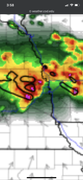
Image is from the latest HRRR forecast model for ~midnight as a bow echo/hail is about to hit Omaha…
-
Busguy2010
- City Council
- Posts: 7397
- Joined: Sun Apr 10, 2011 12:32 am
- Location: North Central Omaha
Re: 2021 Weather thread-
Yep, also just watched David Koeller and he is echoing (no pun intended) everything we've talked about here and what the NWS is saying. 60-70 mph winds possible with heavy rain and hail. I will be holding my breath as it moves in. Don't want to lose power again already, but its definitely got me nervous about it. All I can say is hopefully that last storm took care of what needed to be taken care of tree-care wise, so we don't have another huge power outage.
-
stormchaser
- Planning Board
- Posts: 2380
- Joined: Fri Jun 01, 2018 1:14 pm
Re: 2021 Weather thread-
Storms have started to fire already. One just west of Omaha and another north. Might get interesting in the area soon (though the risk is low with this first round). Main storms will be later still…
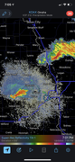
-
Busguy2010
- City Council
- Posts: 7397
- Joined: Sun Apr 10, 2011 12:32 am
- Location: North Central Omaha
Re: 2021 Weather thread-
looks interesting for Lincoln. I kinda think the further southwest sub-area they were indicating snuck a little farther north and almost clipped Omaha, but they appear to be well on their way out of town. Looks like our storms are finally getting going up by Valentine and moving south and east.
-
stormchaser
- Planning Board
- Posts: 2380
- Joined: Fri Jun 01, 2018 1:14 pm
Re: 2021 Weather thread-
Yes sir.
Ping pong sized hail reported just east of Omaha currently moving southeast on this storm
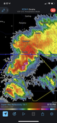
Ping pong sized hail reported just east of Omaha currently moving southeast on this storm
-
stormchaser
- Planning Board
- Posts: 2380
- Joined: Fri Jun 01, 2018 1:14 pm
Re: 2021 Weather thread-
It doesn’t look like much “yet” but up by O’Neill storms are starting to organize more and will eventually form our potential damaging wind event in a few hours as they move this way…
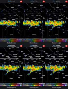
-
Busguy2010
- City Council
- Posts: 7397
- Joined: Sun Apr 10, 2011 12:32 am
- Location: North Central Omaha
Re: 2021 Weather thread-
Yeah, that barely missed us. Looks like the OmaDome in effect for this earlier round, as we have that severe storm to our northeast and what looks like could become a severe storm to our southwest. All moving southeast though, so I fully expect nothing before the big line comes through later, and that may not bode well for us (more fuel).
-
Busguy2010
- City Council
- Posts: 7397
- Joined: Sun Apr 10, 2011 12:32 am
- Location: North Central Omaha
Re: 2021 Weather thread-
Yep, that's the one I was talking about a few posts up and will be keeping my eye on all night. That is our line in the making. Seems like its moving pretty fast, so I wouldn't be surprised if it does show up before 1am. Bill Randby was talking 1-2, but it looks like its moving so fast. Maybe it'll even get here before it gets real bad.stormchaser wrote: Sat Jul 31, 2021 1:22 am It doesn’t look like much “yet” but up by O’Neill storms are starting to organize more and will eventually form our potential damaging wind event in a few hours as they move this way…
We are actually not under a severe thunderstorm watch as of right now, but pretty much every county one county to our south is, so maybe that is an indicator that they think the strongest portions will come to fruition a little south of the metro. We'll see.
-
Busguy2010
- City Council
- Posts: 7397
- Joined: Sun Apr 10, 2011 12:32 am
- Location: North Central Omaha
Re: 2021 Weather thread-
I dont want to speak too soon, but the way it is tracking makes it look like the worst of it would stay just to our west. Wahoo, Ashland. A lot can change in the next two hours, but the whole thing just doesnt seem organized enough to be a beast by the time it reaches Omaha. Maybe we will get lucky, but I bet areas south will probably have something similar to what we had a few weeks ago.