2021 Weather thread-
-
Busguy2010
- City Council
- Posts: 7372
- Joined: Sun Apr 10, 2011 12:32 am
- Location: North Central Omaha
Re: 2021 Weather thread-
Dang it, I was looking at my weather page from a day or two ago. Refreshed it and it looks like the end of the week or even starting today or tomorrow is actually gonna kinda suck. Upper 80s to low 90s, with dew points reaching and surpassing 70.
-
stormchaser
- Planning Board
- Posts: 2380
- Joined: Fri Jun 01, 2018 1:14 pm
Re: 2021 Weather thread-
The weekend actually probably shouldn't be too bad as far as precip chances go anyway. I realize the going forecast shows a chance each day but much of that is a result of the uncertainty between timing for the different forecast models (so they really don't know what to expect currently). From what it looks like right now anyway, the best chance for precip in our area will probably be late Thursday night/Friday (depending on the timing of the front) and possibly again Sunday (if the GFS verifies). Either way, not looking like all-day type events currently. Obviously, things can always change though...Busguy2010 wrote: Mon Aug 16, 2021 4:02 pm Yeah, pretty decent. Good to hear there will be another cold front coming in, despite it being pleasant enough out. Mid 80s is still a bit warm for my liking. It's been the low humidity that has made it. Dew point is definitely getting back up there into the uncomfortable zone, looks like that cold front probably won't be that effective in that regard. As of right now, looks like the whole weekend could be a washout.
-
Busguy2010
- City Council
- Posts: 7372
- Joined: Sun Apr 10, 2011 12:32 am
- Location: North Central Omaha
Re: 2021 Weather thread-
Yeah I just meant chances all weekend.
-
stormchaser
- Planning Board
- Posts: 2380
- Joined: Fri Jun 01, 2018 1:14 pm
Re: 2021 Weather thread-
Ahh, I hear you. I’m guessing they’ll change that once models are in better agreement…
-
Busguy2010
- City Council
- Posts: 7372
- Joined: Sun Apr 10, 2011 12:32 am
- Location: North Central Omaha
Re: 2021 Weather thread-
Yeah, this far out, they probably just say "it could rain at any point Thursday night to Sunday morning", but like you said, most likely there could be periods of rain during that period, with whatever comes first being the most precipitous.stormchaser wrote: Tue Aug 17, 2021 12:45 amAhh, I hear you. I’m guessing they’ll change that once models are in better agreement…
-
stormchaser
- Planning Board
- Posts: 2380
- Joined: Fri Jun 01, 2018 1:14 pm
Re: 2021 Weather thread-
SPC now has "day 4" outlook for much of the area for Friday.
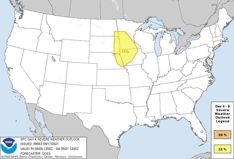
This is actually looking more and more like a setup that would favor supercells/potential tornadoes - at least based on the 12z NAM, especially for areas of northeast NE but possibly in the Omaha area too depending on how far south storms back build and/or the specific location of the boundary/warm front in the area.
At this point, this looks like the most favorable tornado setup we've had in the area for quite a while though (if things verify as shown). Pretty decent chance I'm going chasing though based on current model guidance anyway. Things of course can change and there is some potential that "crapvection" will ruin the environment (too far out to know yet).
Below is a sounding from the 12z NAM showing the favorable wind profiles for rotating storms. Based on this, storms may initially be elevated with the LFC and LCL spread apart indicating more of an elevated storm mode with some capping issues but I'm guessing that's more because storms are just starting to fire/break the cap around 21z which is when this sounding is for (basically ~4 PM storms would probably develop if this verifies).
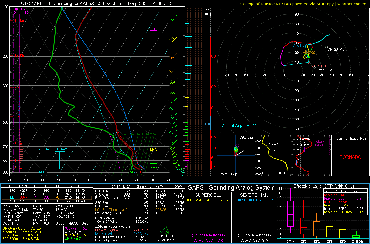
Something to keep an eye on though as we get closer to see what future model runs show and short-range models show as we get close enough to use them.
This is actually looking more and more like a setup that would favor supercells/potential tornadoes - at least based on the 12z NAM, especially for areas of northeast NE but possibly in the Omaha area too depending on how far south storms back build and/or the specific location of the boundary/warm front in the area.
At this point, this looks like the most favorable tornado setup we've had in the area for quite a while though (if things verify as shown). Pretty decent chance I'm going chasing though based on current model guidance anyway. Things of course can change and there is some potential that "crapvection" will ruin the environment (too far out to know yet).
Below is a sounding from the 12z NAM showing the favorable wind profiles for rotating storms. Based on this, storms may initially be elevated with the LFC and LCL spread apart indicating more of an elevated storm mode with some capping issues but I'm guessing that's more because storms are just starting to fire/break the cap around 21z which is when this sounding is for (basically ~4 PM storms would probably develop if this verifies).
Something to keep an eye on though as we get closer to see what future model runs show and short-range models show as we get close enough to use them.
-
Busguy2010
- City Council
- Posts: 7372
- Joined: Sun Apr 10, 2011 12:32 am
- Location: North Central Omaha
Re: 2021 Weather thread-
Man, that temperature forecast just keeps going up. Now talking lower 90s toward the end of the period, so through Monday, and with our storms coming through before then, I'd assume it will be another hot week next week. I cannot wait for that first real fall cold front to come through. I'm talking about an abrupt and recognizable front, like going from 85 for a high to 75, with lows going from 65 to 50 in one day... And staying there or continuing to go down. Gotta be on the horizon soon.
-
Busguy2010
- City Council
- Posts: 7372
- Joined: Sun Apr 10, 2011 12:32 am
- Location: North Central Omaha
Re: 2021 Weather thread-
Looks like they did zero in on the main rain chance being between 1pm Friday and Dawn on Saturday, so not an all weekend deal like what could have been. It sounds more like whatever storm comes through Friday will not be impressive around Omaha.. But with the exception of Saturday being okay, dew points will be killer for the foreseeable future.
-
stormchaser
- Planning Board
- Posts: 2380
- Joined: Fri Jun 01, 2018 1:14 pm
Re: 2021 Weather thread-
Yep, though I’d disagree with the statement about not looking like impressive storms in Omaha. Based on the 00z guidance from this evening it’s looking like the potential for 2 rounds of storms exists in the Omaha area.Busguy2010 wrote: Thu Aug 19, 2021 12:26 am Looks like they did zero in on the main rain chance being between 1pm Friday and Dawn on Saturday, so not an all weekend deal like what could have been. It sounds more like whatever storm comes through Friday will not be impressive around Omaha.. But with the exception of Saturday being okay, dew points will be killer for the foreseeable future.
The first with a potential line of storms dying out as it moves in to eastern NE from the night before (damaging wind potential with these though probably mostly west of Omaha).
Then redevelopment as potential supercells develop across eastern NE with large hail being the biggest threat (tornado potential has decreased some as surface winds are expected to be more south/southwest as opposed to southeasterly like before - still some risk though).
Hard to say at this point if Omaha specifically will be “hit”, but certainly looks like potential is relatively high anyway unless things change…
-
Busguy2010
- City Council
- Posts: 7372
- Joined: Sun Apr 10, 2011 12:32 am
- Location: North Central Omaha
Re: 2021 Weather thread-
The NWS did up their language to "severe thunderstorms" for Friday. But during the noon update I saw from Matt Serwe today, yeah, it looked like two rounds with the first dying out before it reached Omaha, and the second one developing over, but mainly intensifying east of here. I'm a lityle bit intrigued.
-
stormchaser
- Planning Board
- Posts: 2380
- Joined: Fri Jun 01, 2018 1:14 pm
Re: 2021 Weather thread-
Busguy2010 wrote: Thu Aug 19, 2021 5:40 am The NWS did up their language to "severe thunderstorms" for Friday. But during the noon update I saw from Matt Serwe today, yeah, it looked like two rounds with the first dying out before it reached Omaha, and the second one developing over, but mainly intensifying east of here. I'm a lityle bit intrigued.
Ahh - Yeah, he probably showed one of the model runs that held off on redevelopment until east of Omaha (there was a couple briefly that did that). Most model guidance has slowed things down enough for Omaha to be at risk again.
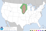
The SPC has a 5% tornado threat currently on there day 2 for our area now also. Not a huge threat obviously but still, should be interesting…
-
Omaha Cowboy

- The Don
- Posts: 1013725
- Joined: Wed Jan 07, 2004 11:31 am
- Location: West Omaha
Re: 2021 Weather thread-
Any idea of what kind of rain event we could expect out of these Friday storms?…stormchaser wrote: Thu Aug 19, 2021 11:21 amBusguy2010 wrote: Thu Aug 19, 2021 5:40 am The NWS did up their language to "severe thunderstorms" for Friday. But during the noon update I saw from Matt Serwe today, yeah, it looked like two rounds with the first dying out before it reached Omaha, and the second one developing over, but mainly intensifying east of here. I'm a lityle bit intrigued.
Ahh - Yeah, he probably showed one of the model runs that held off on redevelopment until east of Omaha (there was a couple briefly that did that). Most model guidance has slowed things down enough for Omaha to be at risk again.
The SPC has a 5% tornado threat currently on there day 2 for our area now also. Not a huge threat obviously but still, should be interesting…
Ciao..LiO…Peace
Go Cowboys!
-
damonhynes

- Parks & Recreation
- Posts: 1282
- Joined: Wed Aug 27, 2014 12:35 am
- Location: Montgomery County, Texas
Re: 2021 Weather thread-
I had one of my best chases in August, a million years ago: https://wordpress.com/post/cyclonerange ... ss.com/100
-
stormchaser
- Planning Board
- Posts: 2380
- Joined: Fri Jun 01, 2018 1:14 pm
Re: 2021 Weather thread-
Amounts locally probably won't be overly impressive. If you happen to get hit by a scattered storm, you'll probably get a quick shot of up to roughly a half-inch of rain. Nothing like our last rain event anyway.Omaha Cowboy wrote: Thu Aug 19, 2021 2:28 pmAny idea of what kind of rain event we could expect out of these Friday storms?…stormchaser wrote: Thu Aug 19, 2021 11:21 amBusguy2010 wrote: Thu Aug 19, 2021 5:40 am The NWS did up their language to "severe thunderstorms" for Friday. But during the noon update I saw from Matt Serwe today, yeah, it looked like two rounds with the first dying out before it reached Omaha, and the second one developing over, but mainly intensifying east of here. I'm a lityle bit intrigued.
Ahh - Yeah, he probably showed one of the model runs that held off on redevelopment until east of Omaha (there was a couple briefly that did that). Most model guidance has slowed things down enough for Omaha to be at risk again.
The SPC has a 5% tornado threat currently on there day 2 for our area now also. Not a huge threat obviously but still, should be interesting…
Ciao..LiO…Peace
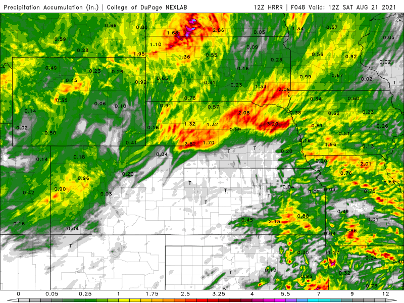
Parts of central/northeast NE could get some pretty heavy rain with the storms expect tonight into early tomorrow morning - some areas over 2" of rain. Also parts of IA could get some pretty heavy rain as our storms eventually grow upscale into more of a line/storm complex as they push east of Omaha and transition into more of a damaging wind event.
Here are the depicted rain totals for the next 48 hours based on the 12z HRRR forecast model.
-
stormchaser
- Planning Board
- Posts: 2380
- Joined: Fri Jun 01, 2018 1:14 pm
Re: 2021 Weather thread-
Unfortunately I wasn't able to get into that link for some reasondamonhynes wrote: Thu Aug 19, 2021 2:35 pm I had one of my best chases in August, a million years ago: https://wordpress.com/post/cyclonerange ... ss.com/100

-
stormchaser
- Planning Board
- Posts: 2380
- Joined: Fri Jun 01, 2018 1:14 pm
Re: 2021 Weather thread-
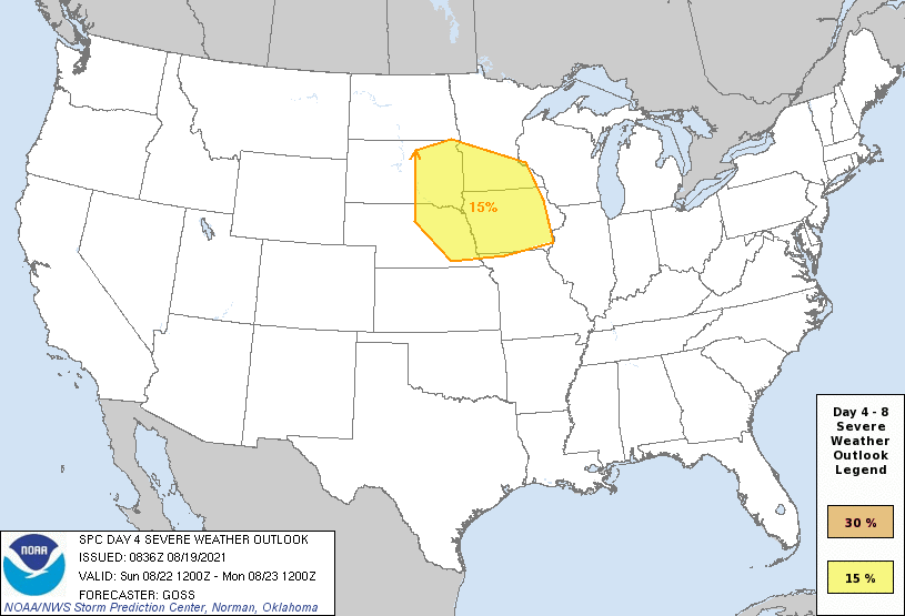
It's also worth noting that this coming Sunday (August 22) poses another risk for severe weather in basically the same area as expected tomorrow with the SPC issuing a day 4 outlook. Long story short, potentially an active few days in the area anyway with Friday and Sunday, in particular, looking interesting.
-
damonhynes
- Parks & Recreation
- Posts: 1282
- Joined: Wed Aug 27, 2014 12:35 am
- Location: Montgomery County, Texas
Re: 2021 Weather thread-
Bummer! Up until a couple weeks ago, I couldn't access Wordpress at work...stormchaser wrote: Thu Aug 19, 2021 2:50 pmUnfortunately I wasn't able to get into that link for some reasondamonhynes wrote: Thu Aug 19, 2021 2:35 pm I had one of my best chases in August, a million years ago: https://wordpress.com/post/cyclonerange ... ss.com/100
-
Busguy2010
- City Council
- Posts: 7372
- Joined: Sun Apr 10, 2011 12:32 am
- Location: North Central Omaha
Re: 2021 Weather thread-
During today's noon run, KETV made it look as if the storms could develop just west of Omaha and at that point being more isolated/greater opportunity for rotation, then they come together and form a line over or just east of Omaha. Sounding like it could be a little impressive now.
-
stormchaser
- Planning Board
- Posts: 2380
- Joined: Fri Jun 01, 2018 1:14 pm
Re: 2021 Weather thread-
Yep, that's what I've been seeing on short-range models too. Omaha itself may or may not get hit but there will definitely be some severe storms in the local area - possibly tornadic but hard to say for sure yet. 12z 3km NAM shows the best potential just northeast of Omaha (for tornadoes I mean). 12z HRRR shows similar but may be slightly further north...with another potential supercell down by Lincoln too.Busguy2010 wrote: Thu Aug 19, 2021 5:53 pm During today's noon run, KETV made it look as if the storms could develop just west of Omaha and at that point being more isolated/greater opportunity for rotation, then they come together and form a line over or just east of Omaha. Sounding like it could be a little impressive now.
Either way, going to be interesting tomorrow...
-
stormchaser
- Planning Board
- Posts: 2380
- Joined: Fri Jun 01, 2018 1:14 pm
Re: 2021 Weather thread-
One thing that will be EXTREMELY important in determining how much tornado risk there is in the Omaha area specifically tomorrow is exactly where the outflow boundary ends up from the overnight storms tonight into early tomorrow morning. Right now it looks like those storms will pass just north of Omaha as they are dying out.
If this happens, an east/west outflow boundary will likely exist very close or just north of Omaha which will increase the low-level helicity and consequently tornado potential. This is why both the 12z 3KM NAM and 12z HRRR show the tornado potential just north of Omaha currently (though very close still).
In my opinion, the greatest tornado potential for tomorrow currently exists somewhere in an area from near Columbus on east/northeast to Mapleton, IA, down to Carroll, IA and Harlan, IA - possibly as far south as I-880 and the Blair area.
If that outflow boundary ends up any further south though, look out in Omaha itself. That's why watching what happens with these storms tonight/early tomorrow will be crucial. If they end up just barely north of Omaha, and the outflow boundary ends up in our area - look out. If they end up further north, the higher-risk area will likely shift north with it.
In addition to where the outflow boundary ends up (assuming there will be one), capping may be an issue as well as "crapvection" which may or may not allow the atmosphere to recover in time for severe storms to develop. Long story short, lots of uncertainty still with this setup...
-
Busguy2010
- City Council
- Posts: 7372
- Joined: Sun Apr 10, 2011 12:32 am
- Location: North Central Omaha
Re: 2021 Weather thread-
Always promising when the confidence goes up like it has for this forecast of the storm tomorrow evening. Started out at 30 or 40%, now is up to 80%.
-
stormchaser
- Planning Board
- Posts: 2380
- Joined: Fri Jun 01, 2018 1:14 pm
Re: 2021 Weather thread-
The track of overnight storms has shifted south some. If this verifies, Omaha will likely get rain/storms tomorrow morning sometime around 9 AM (a few may be strong/severe - especially toward Lincoln).
Then redevelopment is expected in the area by late afternoon/early evening if the atmosphere is able to recover in time (right now it looks like it will). If this scenario plays out as depicted, tornado potential has increased for areas near and south of Omaha - especially in Lincoln, Beatrice, Nebraska City and possibly as far west as York depending on how quickly redevelopment occurs. Tornado potential has decreased for areas north of Omaha now since the track of the overnight storms shifted. Obviously, all this still could change though. We really won't know details until tomorrow morning which areas are most at risk.
Then redevelopment is expected in the area by late afternoon/early evening if the atmosphere is able to recover in time (right now it looks like it will). If this scenario plays out as depicted, tornado potential has increased for areas near and south of Omaha - especially in Lincoln, Beatrice, Nebraska City and possibly as far west as York depending on how quickly redevelopment occurs. Tornado potential has decreased for areas north of Omaha now since the track of the overnight storms shifted. Obviously, all this still could change though. We really won't know details until tomorrow morning which areas are most at risk.
-
Omaha Cowboy
- The Don
- Posts: 1013725
- Joined: Wed Jan 07, 2004 11:31 am
- Location: West Omaha
Re: 2021 Weather thread-
Thanks for the intel- hopefully we can garner a decent amount of rain between tonight and Saturday morning. Lord knows my yard could use it..stormchaser wrote: Thu Aug 19, 2021 2:48 pmAmounts locally probably won't be overly impressive. If you happen to get hit by a scattered storm, you'll probably get a quick shot of up to roughly a half-inch of rain. Nothing like our last rain event anyway.Omaha Cowboy wrote: Thu Aug 19, 2021 2:28 pmAny idea of what kind of rain event we could expect out of these Friday storms?…stormchaser wrote: Thu Aug 19, 2021 11:21 amBusguy2010 wrote: Thu Aug 19, 2021 5:40 am The NWS did up their language to "severe thunderstorms" for Friday. But during the noon update I saw from Matt Serwe today, yeah, it looked like two rounds with the first dying out before it reached Omaha, and the second one developing over, but mainly intensifying east of here. I'm a lityle bit intrigued.
Ahh - Yeah, he probably showed one of the model runs that held off on redevelopment until east of Omaha (there was a couple briefly that did that). Most model guidance has slowed things down enough for Omaha to be at risk again.
The SPC has a 5% tornado threat currently on there day 2 for our area now also. Not a huge threat obviously but still, should be interesting…
Ciao..LiO…Peace
Parts of central/northeast NE could get some pretty heavy rain with the storms expect tonight into early tomorrow morning - some areas over 2" of rain. Also parts of IA could get some pretty heavy rain as our storms eventually grow upscale into more of a line/storm complex as they push east of Omaha and transition into more of a damaging wind event.
Here are the depicted rain totals for the next 48 hours based on the 12z HRRR forecast model.
And all this talk about twisting storm potential over the next several days in Omaha has me feeling very uneasy…
Ciao..LiO…Peace
Go Cowboys!
-
Busguy2010
- City Council
- Posts: 7372
- Joined: Sun Apr 10, 2011 12:32 am
- Location: North Central Omaha
Re: 2021 Weather thread-
As of now, the NWS is talking about .5" to .75", maybe just a tad more. So nothing crazy, but would be an appreciable amount of rain.
-
stormchaser
- Planning Board
- Posts: 2380
- Joined: Fri Jun 01, 2018 1:14 pm
Re: 2021 Weather thread-
Probably targetting somewhere between Lincoln and Beatrice to start today as I feel that area is close to where storm initiation will occur late this afternoon (sometime around 4 or 5 probably). An outflow boundary from overnight storms should be roughly in that area too and there is a decent east/west road to stay with the storms. If a storm can embed on that outflow boundary as it moves east/northeast, tornado potential should increase with that specific storm.
Tornado potential will probably be early on with these storms as the cold front will crash in and storms will gradually become linear and consequently primarily a wind and hail threat. However, just south of Omaha (again where the OFB will be will likely have the best odds for a tornado - somewhere between Omaha and Nebraska City probably). Because of this, tornado potential is probably fairly low in Omaha itself as it appears storms will be more linear by the time they get that far east. I'd expect mostly a wind/hail event in town with a low-end/isolated tornado threat.
Tornado potential will probably be early on with these storms as the cold front will crash in and storms will gradually become linear and consequently primarily a wind and hail threat. However, just south of Omaha (again where the OFB will be will likely have the best odds for a tornado - somewhere between Omaha and Nebraska City probably). Because of this, tornado potential is probably fairly low in Omaha itself as it appears storms will be more linear by the time they get that far east. I'd expect mostly a wind/hail event in town with a low-end/isolated tornado threat.
-
Omaha Cowboy
- The Don
- Posts: 1013725
- Joined: Wed Jan 07, 2004 11:31 am
- Location: West Omaha
Re: 2021 Weather thread-
Getting a much needed dose of rain in my west Omaha neck of the woods…Busguy2010 wrote: Fri Aug 20, 2021 12:46 am As of now, the NWS is talking about .5" to .75", maybe just a tad more. So nothing crazy, but would be an appreciable amount of rain.
Ciao..LiO…Peace
Go Cowboys!
-
Omaha Cowboy
- The Don
- Posts: 1013725
- Joined: Wed Jan 07, 2004 11:31 am
- Location: West Omaha
Re: 2021 Weather thread-
Well, this makes me feel a bit better..stormchaser wrote: Fri Aug 20, 2021 1:05 pm Tornado potential will probably be early on with these storms as the cold front will crash in and storms will gradually become linear and consequently primarily a wind and hail threat. However, just south of Omaha (again where the OFB will be will likely have the best odds for a tornado - somewhere between Omaha and Nebraska City probably). Because of this, tornado potential is probably fairly low in Omaha itself as it appears storms will be more linear by the time they get that far east. I'd expect mostly a wind/hail event in town with a low-end/isolated tornado threat.
Don’t need any more wind or hail..certainly don’t need a Tornado..
But we can keep the rain coming!…
Ciao..LiO…Peace
Go Cowboys!
-
stormchaser
- Planning Board
- Posts: 2380
- Joined: Fri Jun 01, 2018 1:14 pm
Re: 2021 Weather thread-
Then again, the latest short-range models are tempting me more to head north of Omaha to somewhere between here and Sioux City. Too much potential capping down toward where I was thinking initially until the cold front starts crashing in which will cause more linear storms.Omaha Cowboy wrote: Fri Aug 20, 2021 1:41 pmWell, this makes me feel a bit better..stormchaser wrote: Fri Aug 20, 2021 1:05 pm Tornado potential will probably be early on with these storms as the cold front will crash in and storms will gradually become linear and consequently primarily a wind and hail threat. However, just south of Omaha (again where the OFB will be will likely have the best odds for a tornado - somewhere between Omaha and Nebraska City probably). Because of this, tornado potential is probably fairly low in Omaha itself as it appears storms will be more linear by the time they get that far east. I'd expect mostly a wind/hail event in town with a low-end/isolated tornado threat.
Don’t need any more wind or hail..certainly don’t need a Tornado..
But we can keep the rain coming!…
Ciao..LiO…Peace
To be clear, don't let down your guard in Omaha - still definitely some tornado potential here too... a tough forecast today since there isn't really a clear target with this setup. Any storms that fire will have some tornado potential, especially early on before they transition to more of a linear storm mode. Where and when that happens is difficult to know exactly at this point.
-
Omaha Cowboy
- The Don
- Posts: 1013725
- Joined: Wed Jan 07, 2004 11:31 am
- Location: West Omaha
Re: 2021 Weather thread-
If you grew up in or have lived in the Omaha area for a significant period time, It’s sort of imbedded in our DNA- never let our guards down when severe weather is concernedstormchaser wrote: Fri Aug 20, 2021 3:52 pmTo be clear, don't let down your guard in Omaha - still definitely some tornado potential here too...Omaha Cowboy wrote: Fri Aug 20, 2021 1:41 pmWell, this makes me feel a bit better..stormchaser wrote: Fri Aug 20, 2021 1:05 pm Tornado potential will probably be early on with these storms as the cold front will crash in and storms will gradually become linear and consequently primarily a wind and hail threat. However, just south of Omaha (again where the OFB will be will likely have the best odds for a tornado - somewhere between Omaha and Nebraska City probably). Because of this, tornado potential is probably fairly low in Omaha itself as it appears storms will be more linear by the time they get that far east. I'd expect mostly a wind/hail event in town with a low-end/isolated tornado threat.
Don’t need any more wind or hail..certainly don’t need a Tornado..
But we can keep the rain coming!…
Ciao..LiO…Peace
 …
Ciao..LiO…Peace
Go Cowboys!
-
Busguy2010
- City Council
- Posts: 7372
- Joined: Sun Apr 10, 2011 12:32 am
- Location: North Central Omaha
Re: 2021 Weather thread-
They took us down a notch to 60%, moved it a bit earlier and compressed it, and lowered the rain just a little. Majority of it looks like it'll be done by 8, and will happen over the course of an hour or two. I just cant wait for tomorrow when the high will be 83 and the dew point is in the 50s.
-
damonhynes
- Parks & Recreation
- Posts: 1282
- Joined: Wed Aug 27, 2014 12:35 am
- Location: Montgomery County, Texas
Re: 2021 Weather thread-
An hour ago, I was worried about the stratus clouds. I just noticed that the sun's out! C'mon, beautiful cap-eroding radiational heating!
-
Busguy2010
- City Council
- Posts: 7372
- Joined: Sun Apr 10, 2011 12:32 am
- Location: North Central Omaha
Re: 2021 Weather thread-
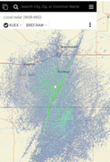
Pretty cool how clearly you can see our front out there.
-
Busguy2010
- City Council
- Posts: 7372
- Joined: Sun Apr 10, 2011 12:32 am
- Location: North Central Omaha
Re: 2021 Weather thread-
There is currently a severe thunderstorm SW of Lincoln and looks like it is currently on a perfect trajectory to hit both Lincoln and Omaha if it holds together. Know things will most likely change and it'll become part of the line when it fills in.
-
Busguy2010
- City Council
- Posts: 7372
- Joined: Sun Apr 10, 2011 12:32 am
- Location: North Central Omaha
Re: 2021 Weather thread-
There is currently a severe thunderstorm SW of Lincoln and looks like it is currently on a perfect trajectory to hit both Lincoln and Omaha if it holds together. Know things will most likely change and it'll become part of the line when it fills in. That looks more like that storm will be what stormchaser predicted will end up hitting Beatrice and Nebraska City, maybe even farther south in Auburn.
Seems like as the front edges close to Omaha with little development west of us currently happening, I've lowered my expectations for now.
Seems like as the front edges close to Omaha with little development west of us currently happening, I've lowered my expectations for now.
-
Busguy2010
- City Council
- Posts: 7372
- Joined: Sun Apr 10, 2011 12:32 am
- Location: North Central Omaha
Re: 2021 Weather thread-
Boy, that'd be incredibly disappointing if we get little to no rain out of this.
-
stormchaser
- Planning Board
- Posts: 2380
- Joined: Fri Jun 01, 2018 1:14 pm
Re: 2021 Weather thread-
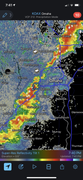
Storms filling in quick now right over Omaha…Busguy2010 wrote: Sat Aug 21, 2021 12:20 am Boy, that'd be incredibly disappointing if we get little to no rain out of this.
-
Busguy2010
- City Council
- Posts: 7372
- Joined: Sun Apr 10, 2011 12:32 am
- Location: North Central Omaha
Re: 2021 Weather thread-
Glad I said that because that storm really did pop up over the course of like 5 minutes, and it was after the front already moved through.
-
Busguy2010
- City Council
- Posts: 7372
- Joined: Sun Apr 10, 2011 12:32 am
- Location: North Central Omaha
Re: 2021 Weather thread-
According to Bill Randby tonight, I shouldn't expect a big cool down in the 14 day period. Frickin hot this week and seasonable (low to mid 80's) next week, which is still hot IMO. Small rain chances for a good stretch, but likely to amount to next to nothing.
I CANNOT wait for that first true fall front to come in and squander any chance we ever see another 80+ day until April. We'll know it when it happens, but unfortunately it could be about another month. Our last hot day last year was September 25th. Funny that I just remembered on September 25th, 2018, I went fishing, and by 10pm, it was so cold I couldn't feel my fingers, wore a hat and blasted the heat on my way home. Probably was about 48 around that time on that night. Fall is a crapshoot though, just hope to see cooler weather sooner rather than later.
I CANNOT wait for that first true fall front to come in and squander any chance we ever see another 80+ day until April. We'll know it when it happens, but unfortunately it could be about another month. Our last hot day last year was September 25th. Funny that I just remembered on September 25th, 2018, I went fishing, and by 10pm, it was so cold I couldn't feel my fingers, wore a hat and blasted the heat on my way home. Probably was about 48 around that time on that night. Fall is a crapshoot though, just hope to see cooler weather sooner rather than later.
-
Cermak
- Planning Board
- Posts: 2340
- Joined: Thu Nov 29, 2018 7:02 pm
Re: 2021 Weather thread-
This past Saturday was probably one of the nicest days all summer. But Sunday afternoon it warmed up and the rest of this week looks hot.
-
Busguy2010
- City Council
- Posts: 7372
- Joined: Sun Apr 10, 2011 12:32 am
- Location: North Central Omaha
Re: 2021 Weather thread-
I agree. Meant to say something along those lines. It was one of four days that the high was 80 or less. Nicest days this since June 1 were 80, 80, 77, 74. Those 70's seem like an eternity ago and I'm beyond sick of 90+. I NEED fall to show itself soon.Cermak wrote: Mon Aug 23, 2021 1:20 pm This past Saturday was probably one of the nicest days all summer. But Sunday afternoon it warmed up and the rest of this week looks hot.