The next chance for storms in the Omaha area (some of which could be strong/severe) looks to occur Tomorrow evening (8-24) in my opinion anyway. For clarification, I realize the NWS only has a 20% in our area currently, but based on model trends from the 12z run of models, I'd expect that risk to increase if those trends continue.
Currently, the 12z run of the HRRR, 3km NAM, NAM, GFS, and ECMWF all show this potential. Some models are more aggressive in the potential for severe weather than others, but pretty much all of them show storms in the area at least.
With the heat expected tomorrow (upper 90s in our area), one of the biggest issues with these storms actually happening will be potential capping. This is why most storms will probably hold off until near or after sunset. Assuming the cap can be broken, damaging wind and hail will be the main threats. Considering the hot temps though, storm bases will probably be pretty elevated so tornado potential will be low.
Anyhow, not a "slam dunk" by any means that we will get anything in Omaha itself but don't be surprised if we do...
2021 Weather thread-
-
stormchaser
- Planning Board
- Posts: 2380
- Joined: Fri Jun 01, 2018 1:14 pm
-
Omaha Cowboy

- The Don
- Posts: 1013737
- Joined: Wed Jan 07, 2004 11:31 am
- Location: West Omaha
Re: 2021 Weather thread-
I’ll just take whatever rain these potential storms will provide..
Minus a damaging wind/hail event…
Ciao..LiO…Peace
Minus a damaging wind/hail event…
Ciao..LiO…Peace
Go Cowboys!
-
stormchaser
- Planning Board
- Posts: 2380
- Joined: Fri Jun 01, 2018 1:14 pm
Re: 2021 Weather thread-
Odds continue to increase that a few isolated strong/severe storms (low risk though) will happen in or near Omaha tomorrow night before things transition to a localized heavy rain event. It shouldn’t be anything like a few weeks ago (hopefully) but I wouldn’t be surprised to see a few places get in excess of an inch of rain over a few hours before things gradually die off if models verify anyway.
I fully expect the NWS to up precip chances for tomorrow night as trends have continued on the 00z run (with the 3km NAM very similar to the HRRR now). Last I saw they were up to 30%, I’d expect that to jump up to 60% or 70% by tomorrow morning (though I guess we will see).
I fully expect the NWS to up precip chances for tomorrow night as trends have continued on the 00z run (with the 3km NAM very similar to the HRRR now). Last I saw they were up to 30%, I’d expect that to jump up to 60% or 70% by tomorrow morning (though I guess we will see).
-
stormchaser
- Planning Board
- Posts: 2380
- Joined: Fri Jun 01, 2018 1:14 pm
Re: 2021 Weather thread-
Looks like they only increased it to 40% so far which surprises me. Oh well, at this point unless things somehow drastically change (which is possible though unlikely), Omaha will likely get storms tonight with some potential for strong/severe storms (including a very low tornado risk). The main threat for severe stuff is probably highest just west/northwest of town (Columbus/Fremont area roughly and into far western IA)…but storms should gradually move east/southeast into Omaha
-
stormchaser
- Planning Board
- Posts: 2380
- Joined: Fri Jun 01, 2018 1:14 pm
Re: 2021 Weather thread-
Models have finally backed off on storms for tonight. There is a chance for a few/isolated storms but in general, capping will probably hold strong. Oh well...
-
Busguy2010

- City Council
- Posts: 7393
- Joined: Sun Apr 10, 2011 12:32 am
- Location: North Central Omaha
Re: 2021 Weather thread-
Ooowee! Quite a rough stretch coming the next few days. Heat indexes surpassing 100 through Sunday. Luckily I feel pretty well acclimated by now, and also the sun angle is noticeably lower and the days shorter now. Thankfully. Next okay day looks like Monday.
As for tonight, it looks sparse, but maybe we will get a brief appendage of one of the storms up north and get some rain. NWS currently talking about ~ .25", which is not bad for a small chance.
As for tonight, it looks sparse, but maybe we will get a brief appendage of one of the storms up north and get some rain. NWS currently talking about ~ .25", which is not bad for a small chance.
-
stormchaser
- Planning Board
- Posts: 2380
- Joined: Fri Jun 01, 2018 1:14 pm
Re: 2021 Weather thread-
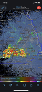
Then again, cap broke with severe warned storms near Columbus to near Wahoo. Looks like it’s going to probably be an interesting night in Omaha with potential for hail and heavy rain over the next few hours.
Probably shouldn’t have second guessed my forecast as things are playing out basically as expected where I thought they would but models did briefly back off on potential. Such is forecasting though.
Multiple warned storms slowly moving this way…
Probably shouldn’t have second guessed my forecast as things are playing out basically as expected where I thought they would but models did briefly back off on potential. Such is forecasting though.
Multiple warned storms slowly moving this way…
-
Busguy2010
- City Council
- Posts: 7393
- Joined: Sun Apr 10, 2011 12:32 am
- Location: North Central Omaha
Re: 2021 Weather thread-
Wow, yeah they are definitely coming together. Good lightning show directly west and looks like they could train over Omaha. I definitely had my doubts about tonight, but it looks like it could become something.
-
Busguy2010
- City Council
- Posts: 7393
- Joined: Sun Apr 10, 2011 12:32 am
- Location: North Central Omaha
Re: 2021 Weather thread-
Won't be long western Douglas county will feel effects. Wouldnt be surprised if Omaha gets severe warned.
-
stormchaser
- Planning Board
- Posts: 2380
- Joined: Fri Jun 01, 2018 1:14 pm
Re: 2021 Weather thread-
Multiple large branches/trees down here in Millard again…
Last edited by stormchaser on Wed Aug 25, 2021 7:04 am, edited 1 time in total.
-
Busguy2010
- City Council
- Posts: 7393
- Joined: Sun Apr 10, 2011 12:32 am
- Location: North Central Omaha
Re: 2021 Weather thread-
Wow, what a light show! I'm trying to sleep in my basement because of the heat, so I only have a tiny window, but so many flashes of lightning illuminating my whole |expletive| dark basement. As well as plenty of close CG strikes.
-
Cermak
- Planning Board
- Posts: 2348
- Joined: Thu Nov 29, 2018 7:02 pm
Re: 2021 Weather thread-
Noticed some medium and small branches down in 114th and Center area, don’t see any large trees or branches down and the power never went out, we had one gust that was maybe 45-55 mph. The July 10th storm started with some 40-60 mph gust then followed by the big gust that must of been around 90 mph. The 90 mph gust took large branches down as well as large trees and rattled my windows at its worst point.
-
stormchaser
- Planning Board
- Posts: 2380
- Joined: Fri Jun 01, 2018 1:14 pm
Re: 2021 Weather thread-
Yeah, we have some between 120th and 132nd south of Center. One in particular that’s large (almost the size of a tree) that came down in my yard and is going to require a chainsaw. I can’t say for sure how many elsewhere. I’d say we had a gust of about 65 here but I’m just estimating…
-
stormchaser
- Planning Board
- Posts: 2380
- Joined: Fri Jun 01, 2018 1:14 pm
Re: 2021 Weather thread-
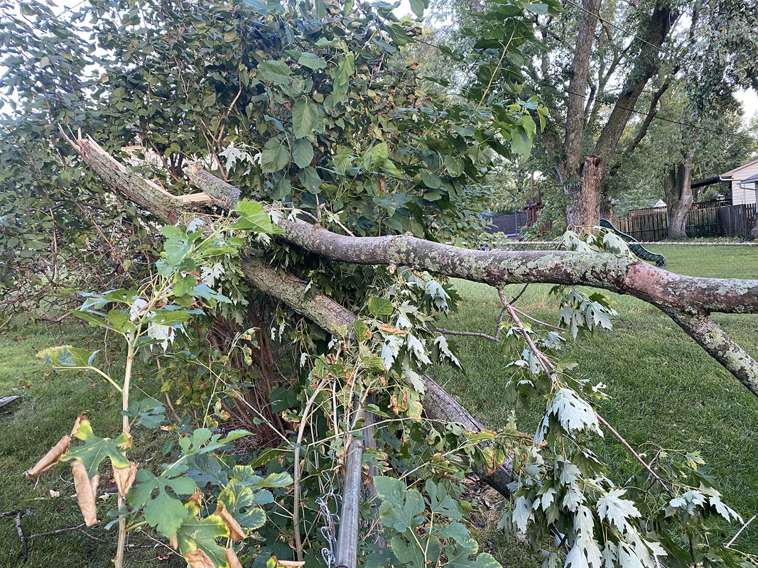
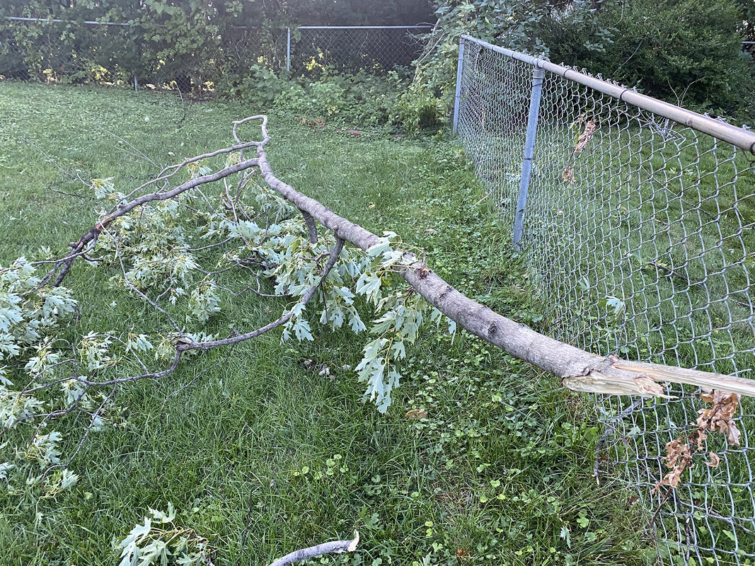
Based on the amount of tree damage in my neighborhood, I'm wondering if we had a microburst in our area. Didn't notice nearly as much damage elsewhere on my way to work but maybe I couldn't see it.
Certainly nothing like what happened in July (not surprising) but still some damage around town based on the storm reports from yesterday...
https://www.spc.noaa.gov/climo/reports/yesterday.html
Certainly nothing like what happened in July (not surprising) but still some damage around town based on the storm reports from yesterday...
https://www.spc.noaa.gov/climo/reports/yesterday.html
-
skinzfan23
- City Council
- Posts: 11672
- Joined: Mon Feb 09, 2004 5:26 pm
- Location: Omaha/Bellevue
Re: 2021 Weather thread-
Friday, all the local weather channels were talking about the "big storm" we were going to get and in Bellevue we got a few sprinkles.
Last night, they mentioned that there was a small chance of a storm, we got 1.25in SW of Offutt.
What a great storm for lightning and thunder though.
Last night, they mentioned that there was a small chance of a storm, we got 1.25in SW of Offutt.
What a great storm for lightning and thunder though.
-
damonhynes

- Parks & Recreation
- Posts: 1282
- Joined: Wed Aug 27, 2014 12:35 am
- Location: Montgomery County, Texas
Re: 2021 Weather thread-
There are times when I'm glad to be wrong! Glorious lightning and thunder!stormchaser wrote: Wed Aug 25, 2021 4:07 am Then again, cap broke with severe warned storms near Columbus to near Wahoo. Looks like it’s going to probably be an interesting night in Omaha with potential for hail and heavy rain over the next few hours.
Probably shouldn’t have second guessed my forecast as things are playing out basically as expected where I thought they would but models did briefly back off on potential. Such is forecasting though.
Multiple warned storms slowly moving this way…
-
stormchaser
- Planning Board
- Posts: 2380
- Joined: Fri Jun 01, 2018 1:14 pm
Re: 2021 Weather thread-
For what it’s worth, I was the only one I know of anyway mentioning the potential for a full 1.5 days in advance (even said some places may get over an inch of rain - see comments above for what I was thinking anywayskinzfan23 wrote: Wed Aug 25, 2021 1:35 pm Friday, all the local weather channels were talking about the "big storm" we were going to get and in Bellevue we got a few sprinkles.
Last night, they mentioned that there was a small chance of a storm, we got 1.25in SW of Offutt.
What a great storm for lightning and thunder though.
) but such is forecasting - extremely difficult at times since small changes in how things come together can make HUGE differences in how things play out. Last night the big question was capping which obviously broke but for a while, it looked like it might not (which is why I briefly second-guessed myself)…-
stormchaser
- Planning Board
- Posts: 2380
- Joined: Fri Jun 01, 2018 1:14 pm
Re: 2021 Weather thread-
Yes sir! Definitely a pretty intense storm!damonhynes wrote: Wed Aug 25, 2021 1:44 pmThere are times when I'm glad to be wrong! Glorious lightning and thunder!stormchaser wrote: Wed Aug 25, 2021 4:07 am Then again, cap broke with severe warned storms near Columbus to near Wahoo. Looks like it’s going to probably be an interesting night in Omaha with potential for hail and heavy rain over the next few hours.
Probably shouldn’t have second guessed my forecast as things are playing out basically as expected where I thought they would but models did briefly back off on potential. Such is forecasting though.
Multiple warned storms slowly moving this way…
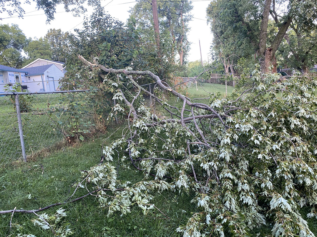
Here are a few damage pics from my yard (a bit difficult to judge the scale of everything in the pics but the larger branch is probably around 8" in diameter). Was going to mow today - probably not going to happen now though...
-
Busguy2010
- City Council
- Posts: 7393
- Joined: Sun Apr 10, 2011 12:32 am
- Location: North Central Omaha
Re: 2021 Weather thread-
I think you must have had an isolated stronger part. I was trying to sleep in my basement when the storm came through and I barely heard any wind or rain, but what was incredible was the lightning. Now, unfortunately I couldn't see the actual lightning, but the flashes were constantly lighting up my basement. Too bad I was too tired to get up and actually watch it. But I definitely heard some close cg strikes, and I heard my very last close cg strike at 2:40, then it seemed to be on its way out and I could finally fall asleep. The light show lasted a good 2 hours at least. Pretty incredible.
Somehow the NWS only reporting .02". I'm gonna say around my parts, we got at least about .15", just based off feel, cause I did briefly walk back upstairs and looked out the window for a sec.
Somehow the NWS only reporting .02". I'm gonna say around my parts, we got at least about .15", just based off feel, cause I did briefly walk back upstairs and looked out the window for a sec.
-
Busguy2010
- City Council
- Posts: 7393
- Joined: Sun Apr 10, 2011 12:32 am
- Location: North Central Omaha
Re: 2021 Weather thread-
According to lightning maps, indeed outside of a few strikes, all the action mainly happened south of Dodge. Its a pretty notable cutoff.
-
stormchaser
- Planning Board
- Posts: 2380
- Joined: Fri Jun 01, 2018 1:14 pm
Re: 2021 Weather thread-
Radar estimates are showing 1” (light blue) to 1.5” (Green) of rain in the southern half of Omaha. Eppley is where the official rain total comes from and they mostly were missed by the heavy stuff this time which I’m assuming is why that total is so low…Busguy2010 wrote: Wed Aug 25, 2021 4:25 pm Somehow the NWS only reporting .02". I'm gonna say around my parts, we got at least about .15", just based off feel, cause I did briefly walk back upstairs and looked out the window for a sec.
-
nebugeater

- City Council
- Posts: 111064
- Joined: Wed Aug 04, 2004 11:07 pm
- Location: Gretna NE
Re: 2021 Weather thread-
In Gretna, I had 1.2" in my gauge at 4:45 this morning. The storm was plenty strong too as it works me and kept me awake for quite a while.
For the record NEBUGEATER does not equal BUGEATER !!!!!!!
-
Busguy2010
- City Council
- Posts: 7393
- Joined: Sun Apr 10, 2011 12:32 am
- Location: North Central Omaha
Re: 2021 Weather thread-
Just talked to my mom who lives down the street, she checked her rain gauge and it said about .4" in North Central. I never did check my own, but I am always skeptical of in-town measurements because rain can accumulate on trees and skew measurements. And on the other hand, the .02" measurement that will go down in the history books also isn't accurate, because the storm didn't even hit Eppley.
Over-all, of course, with the month coming to an end, it looks like we are most likely to end up with an official deficit. Although, I realize we have had some very heavy rain events this month, so I feel like in reality, we are not at a deficit for the month. However, the ground still dries out quickly. Not much more than 3 days of no rain and the ground is cracking up. I think this has to do with our some 12"+ deficit we acquired over the course of 2020.
Over-all, of course, with the month coming to an end, it looks like we are most likely to end up with an official deficit. Although, I realize we have had some very heavy rain events this month, so I feel like in reality, we are not at a deficit for the month. However, the ground still dries out quickly. Not much more than 3 days of no rain and the ground is cracking up. I think this has to do with our some 12"+ deficit we acquired over the course of 2020.
-
Brad

- Photographer
- Posts: 1036702
- Joined: Sun Feb 29, 2004 12:03 am
- Location: Omaha, NE
Re: 2021 Weather thread-
I always put my out in the lawn, away from trees, wires, etc. I ended up with just over a half inch. I measured 0.78" but I had started the sprinklers not expecting any rain. Judging by the bar graph, I got just over 0.5" near 90th and Center.Busguy2010 wrote: Wed Aug 25, 2021 6:36 pm I am always skeptical of in-town measurements because rain can accumulate on trees and skew measurements. And on the other hand, the .02" measurement that will go down in the history books also isn't accurate, because the storm didn't even hit Eppley.
Eppley did get a little rain, I actually thought they would show a little more than 0.2, but not a lot.

Omaha Skyline Photos, Omaha Aerial Photos, and More.
Website: www.bradwilliamsphotography.com
Facebook: www.facebook.com/bradwilliamsphotography
Twitter: www.twitter.com/bradwphoto
Instagram: www.instagram.com/bradwilliamsphotography
YouTube: www.youtube.com/@bradwilliamsphoto
-
stormchaser
- Planning Board
- Posts: 2380
- Joined: Fri Jun 01, 2018 1:14 pm
Re: 2021 Weather thread-
Storms are again starting to fire north of Omaha along a east/west boundary in the area (near Tekamah north of Missouri Valley). Cap is breaking again so a few of these could become strong/severe over the next few hours. Doesn’t look like much on radar “yet” but look out if in the area. Storms might struggle to sustain themselves since they are barely moving (so eventually they may collapse on themselves).
Most of the activity “should” stay north of Omaha though but it’s tough to say since the boundary is slowly moving south currently.
Most of the activity “should” stay north of Omaha though but it’s tough to say since the boundary is slowly moving south currently.
-
Busguy2010
- City Council
- Posts: 7393
- Joined: Sun Apr 10, 2011 12:32 am
- Location: North Central Omaha
Re: 2021 Weather thread-
You can see that boundary you speak of pretty clearly on radar, just a little north of Blair. But it is moving southward and there is definitely some building happening.
Looks like there are two boundaries generally moving in the same direction about to converge. Don't know what that means for potential rain and thunderstorms along it.
Totally weird that they have a NE to SW progression to them, but they also appear to be fizzling out.
Looks like there are two boundaries generally moving in the same direction about to converge. Don't know what that means for potential rain and thunderstorms along it.
Totally weird that they have a NE to SW progression to them, but they also appear to be fizzling out.
-
stormchaser
- Planning Board
- Posts: 2380
- Joined: Fri Jun 01, 2018 1:14 pm
Re: 2021 Weather thread-
Yep, storms fired along the outflow boundary but mid-level steering winds aren’t strong enough so storms couldn’t move fast enough to prevent the storms from being completely undercut by the outflow boundary and consequently they are now dying. Between that and stronger capping down here anyway. They were briefly pretty strong though, even occasionally had some broad rotation with them but alas, they are basically dead now.Busguy2010 wrote: Wed Aug 25, 2021 11:35 pm You can see that boundary you speak of pretty clearly on radar, just a little north of Blair. But it is moving southward and there is definitely some building happening.
Looks like there are two boundaries generally moving in the same direction about to converge. Don't know what that means for potential rain and thunderstorms along it.
Totally weird that they have a NE to SW progression to them, but they also appear to be fizzling out.
Here is a radar loop showing as the outflow boundary started pulling away from the storms which cut off their warm air supply and consequently quickly killed them. Pretty cool IMO…
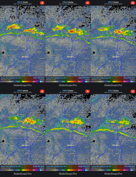
Boundary at least is pushing into Omaha, temps should drop quickly and wind will briefly pick up anyway…
-
Busguy2010
- City Council
- Posts: 7393
- Joined: Sun Apr 10, 2011 12:32 am
- Location: North Central Omaha
Re: 2021 Weather thread-
I'll take cooler temps if nothing else. I personally wasn't expecting anything today, or for the rest of the forecast period tbh outside of Saturday night... That looks like the next one worth keeping an eye on, but I do attest there are small chances for rain/thunderstorms pretty much every day now, but nothing I will pay much attention to until Saturday.
-
stormchaser
- Planning Board
- Posts: 2380
- Joined: Fri Jun 01, 2018 1:14 pm
Re: 2021 Weather thread-
Friday looks pretty decent on mid-range models too depending on timing. Potentially a damaging wind event again in the area if things verify as shown. Hard to say yet anyway but will know more once the 00z HRRR run is available. Possibly another damaging wind event Saturday too…Busguy2010 wrote: Thu Aug 26, 2021 12:40 am I'll take cooler temps if nothing else. I personally wasn't expecting anything today, or for the rest of the forecast period tbh outside of Saturday night... That looks like the next one worth keeping an eye on, but I do attest there are small chances for rain/thunderstorms pretty much every day now, but nothing I will pay much attention to until Saturday.
-
Busguy2010
- City Council
- Posts: 7393
- Joined: Sun Apr 10, 2011 12:32 am
- Location: North Central Omaha
Re: 2021 Weather thread-
Sounded like we could be skirted by parts of the severe event(s) up north but we are not in the focus area. I'll definitely take what we get but I won't be spending much energy on the next few days, I don't think.
-
stormchaser
- Planning Board
- Posts: 2380
- Joined: Fri Jun 01, 2018 1:14 pm
Re: 2021 Weather thread-
Yeah, it's really tough to say yet though. Based on the SPC, most everything will stay north of here the next couple of days but based on recent model trends, don't be surprised if that changes at least somewhat and that the SPC extends some risk down into our area (especially Friday/Saturday based on the 12z model runs anyway). Even tomorrow night there is at least "some" risk not far from here (probably north of us though how much does pushing this outflow boundary south unexpectedly into our area end up changing things for tomorrow? Only time will tell).Busguy2010 wrote: Thu Aug 26, 2021 12:58 am Sounded like we could be skirted by parts of the severe event(s) up north but we are not in the focus area. I'll definitely take what we get but I won't be spending much energy on the next few days, I don't think.
It's all going to come down to what the capping does though for Friday/Saturday in particular which is one of the more difficult things to forecast in advance. Especially since model agreement hasn't been great with the upcoming potential so it would be nice if that increases and if we could get some run to run consistency.
00z HRRR is loading now so I'll post my thoughts on the going forecast in about an hour (or less) for the next few days
...-
Busguy2010
- City Council
- Posts: 7393
- Joined: Sun Apr 10, 2011 12:32 am
- Location: North Central Omaha
Re: 2021 Weather thread-
Yeah, it looks like we are almost at slight risk for whatever happens tomorrow morning and tomorrow night, and am never surprised to see us included when the risk is that close. Sounds like about 6, 7, 8, 9, 10am tomorrow morning, then again after 7pm. Then another chance Friday afternoon/evening. The timing/not sounding that great have me disinterested in following until Saturday night around dark sounds like a much better chance as of now.
-
stormchaser
- Planning Board
- Posts: 2380
- Joined: Fri Jun 01, 2018 1:14 pm
Re: 2021 Weather thread-
Based on the 00z HRRR...
Thursday:
A fairly significant severe weather day appears possible for people to our north and east from parts of southeast SD, northeast, NE, southwest MN, and the northern half of IA. A fairly widespread damaging wind event is anticipated as well as the potential for a few tornadoes, especially in parts of northeast NE and northwest IA. This looks like it "could" be a full-blown derecho so widespread, significant wind damage will be possible in some areas, unfortunately - which is obviously bad news for farmers who may be impacted.
The line of storms does get close to Omaha but ultimately passes just north/and east of here (by ~30 miles) and hits Des Moines pretty hard so it's close enough it will need to be watched closely (though the worst will likely be north/northwest of Des Moines in the northern half of the state).
How warm the 700mb temps get will be key in determining if Omaha will get hit as the storms will likely ride along the northern edge of this area or "bubble" of hotter temps aloft. It will be interesting to see if that outflow boundary that pushed through tonight will help with keeping the hotter 700mb temps to our south and consequently cause Omaha to get hit. Only time will tell if it makes any difference at all but it's certainly possible.
I'm actually tempted to go chasing tomorrow in northwest IA.
Friday:
The forecast for Friday is highly dependant on what happens with everything tomorrow. If things play out as shown tomorrow, then severe weather is possible in our area along a boundary from the previous day's storms. All storm modes will be possible during the mid to late afternoon into the evening if things verify as shown including potential supercells and the threat for large hail, damaging wind, and isolated tornadoes (though that threat currently appears low).
If models trends continue (and depending on how things play out tomorrow), don't be surprised if the SPC puts out a risk area down into our neck of the woods for Friday. Something definitely worth keeping a close eye on though.
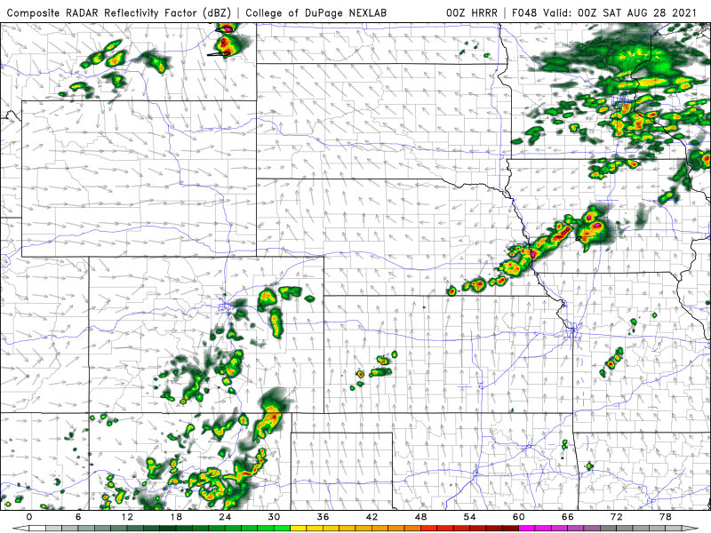
Below is an image showing the simulated radar from the 00z HRRR for around 7 PM Friday evening. The threat certainly isn't as high as tomorrow to our north but definitely the potential anyway for some severe weather in the area.
Saturday:
A cold front is expected to move across the northern plains including our area. This will probably lead to some strong/severe storms in our area - mostly a damaging wind and hail threat. However, this threat will be dependent on the timing of the cold front and potential capping. Since specifics are unknown and dependent on what happens both Thursday/Friday, it's tough to know exactly when, where and to what extent this threat will be.
Anyhow, just my 2 cents for what it's worth
Thursday:
A fairly significant severe weather day appears possible for people to our north and east from parts of southeast SD, northeast, NE, southwest MN, and the northern half of IA. A fairly widespread damaging wind event is anticipated as well as the potential for a few tornadoes, especially in parts of northeast NE and northwest IA. This looks like it "could" be a full-blown derecho so widespread, significant wind damage will be possible in some areas, unfortunately - which is obviously bad news for farmers who may be impacted.
The line of storms does get close to Omaha but ultimately passes just north/and east of here (by ~30 miles) and hits Des Moines pretty hard so it's close enough it will need to be watched closely (though the worst will likely be north/northwest of Des Moines in the northern half of the state).
How warm the 700mb temps get will be key in determining if Omaha will get hit as the storms will likely ride along the northern edge of this area or "bubble" of hotter temps aloft. It will be interesting to see if that outflow boundary that pushed through tonight will help with keeping the hotter 700mb temps to our south and consequently cause Omaha to get hit. Only time will tell if it makes any difference at all but it's certainly possible.
I'm actually tempted to go chasing tomorrow in northwest IA
.Friday:
The forecast for Friday is highly dependant on what happens with everything tomorrow. If things play out as shown tomorrow, then severe weather is possible in our area along a boundary from the previous day's storms. All storm modes will be possible during the mid to late afternoon into the evening if things verify as shown including potential supercells and the threat for large hail, damaging wind, and isolated tornadoes (though that threat currently appears low).
If models trends continue (and depending on how things play out tomorrow), don't be surprised if the SPC puts out a risk area down into our neck of the woods for Friday. Something definitely worth keeping a close eye on though.
Below is an image showing the simulated radar from the 00z HRRR for around 7 PM Friday evening. The threat certainly isn't as high as tomorrow to our north but definitely the potential anyway for some severe weather in the area.
Saturday:
A cold front is expected to move across the northern plains including our area. This will probably lead to some strong/severe storms in our area - mostly a damaging wind and hail threat. However, this threat will be dependent on the timing of the cold front and potential capping. Since specifics are unknown and dependent on what happens both Thursday/Friday, it's tough to know exactly when, where and to what extent this threat will be.
Anyhow, just my 2 cents for what it's worth
-
stormchaser
- Planning Board
- Posts: 2380
- Joined: Fri Jun 01, 2018 1:14 pm
Re: 2021 Weather thread-
Severe warned storm just north of Omaha currently. It “might” build south enough to hit Omaha in the next hour or 2. Regardless, this storm complex will probably decrease our chances for storms later today depending how long they stay in the area (even though most were expected to miss us anyhow).
I see the SPC added a day 2 outlook for tomorrow that includes Omaha in a slight risk (just barely for now). Still think tomorrow depends on how today comes together so if things change too much, tomorrow’s risk may not pan out.
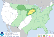
I see the SPC added a day 2 outlook for tomorrow that includes Omaha in a slight risk (just barely for now). Still think tomorrow depends on how today comes together so if things change too much, tomorrow’s risk may not pan out.
-
Busguy2010
- City Council
- Posts: 7393
- Joined: Sun Apr 10, 2011 12:32 am
- Location: North Central Omaha
Re: 2021 Weather thread-
Hmm, weird. The NWS is saying 70% chance of showers and thunderstorms for Saturday night, while KETV just said 20%. I wonder how they could get such different numbers 
-
damonhynes
- Parks & Recreation
- Posts: 1282
- Joined: Wed Aug 27, 2014 12:35 am
- Location: Montgomery County, Texas
Re: 2021 Weather thread-
I'm sure Santeria is involved...:-)Busguy2010 wrote: Thu Aug 26, 2021 5:52 pm Hmm, weird. The NWS is saying 70% chance of showers and thunderstorms for Saturday night, while KETV just said 20%. I wonder how they could get such different numbers
-
stormchaser
- Planning Board
- Posts: 2380
- Joined: Fri Jun 01, 2018 1:14 pm
Re: 2021 Weather thread-
Yeah, that's quite the difference - lol. I'm assuming it's because there really isn't great model agreement currently which always increases the uncertainty of how things will actually play out or come together. Even tomorrow - at this point is looking like a toss up, to be honest, if anything will even fire in or near the area outlined by the SPC. At least some of the models are showing things remaining capped now for tomorrow. Guess we will see.Busguy2010 wrote: Thu Aug 26, 2021 5:52 pm Hmm, weird. The NWS is saying 70% chance of showers and thunderstorms for Saturday night, while KETV just said 20%. I wonder how they could get such different numbers
Since with weather (and many things really), "for every action, there is a reaction" - how much do things change on Saturday if things play out differently on Friday? Does the cold front slow down and end up mostly west of here? Even today things have played out differently than expected with a much larger area of rain that is basically killing off most of the daytime potential in the area at risk (there will still be some storms tonight though).
Gotta love forecasting though
-
stormchaser
- Planning Board
- Posts: 2380
- Joined: Fri Jun 01, 2018 1:14 pm
Re: 2021 Weather thread-
Based on visible satellite anyway and the mesoanalysis, storms are at least trying to fire north of Omaha currently with an old outflow boundary pushing south into the area. Will be interesting to see if anything develops over the next hour or 2. Short-range HRRR is also showing storms firing in or near Omaha over the next couple of hours. Odds are low since temps aloft are still pretty warm but something to keep a close eye on...
-
Omaha Cowboy
- The Don
- Posts: 1013737
- Joined: Wed Jan 07, 2004 11:31 am
- Location: West Omaha
Re: 2021 Weather thread-
Is Friday afternoon into early evening looking to be quiet along the storm/rain front?…stormchaser wrote: Thu Aug 26, 2021 9:51 pm Based on visible satellite anyway and the mesoanalysis, storms are at least trying to fire north of Omaha currently with an old outflow boundary pushing south into the area. Will be interesting to see if anything develops over the next hour or 2. Short-range HRRR is also showing storms firing in or near Omaha over the next couple of hours. Odds are low since temps aloft are still pretty warm but something to keep a close eye on...
Ciao..LiO…Peace
Go Cowboys!
-
stormchaser
- Planning Board
- Posts: 2380
- Joined: Fri Jun 01, 2018 1:14 pm
Re: 2021 Weather thread-
For the most part, yes. There is an outside chance for a few spotty showers or storms over the next couple of hours (mostly to our north) but in general, it's looking more and more like the cap is going to be too strong in our area for anything to really happen today with most of the storm potential into northeast IA & WI (where temps aloft are cooler).Omaha Cowboy wrote: Fri Aug 27, 2021 4:30 amIs Friday afternoon into early evening looking to be quiet along the storm/rain front?…stormchaser wrote: Thu Aug 26, 2021 9:51 pm Based on visible satellite anyway and the mesoanalysis, storms are at least trying to fire north of Omaha currently with an old outflow boundary pushing south into the area. Will be interesting to see if anything develops over the next hour or 2. Short-range HRRR is also showing storms firing in or near Omaha over the next couple of hours. Odds are low since temps aloft are still pretty warm but something to keep a close eye on...
Ciao..LiO…Peace
For Saturday, it's looking like the cold front has slowed down as well which means Omaha may be missed on Saturday with most of the storm activity occurring west and north of here. Still, time for things to change but currently trending towards quieter in the local area over the next few days.