2021 Weather thread-

Grand Island, Hastings, Kearney, Des Moines, and the rest of Nebraska and Iowa
User avatar
Omaha Cowboy
The Don
Posts: 1013731
Joined: Wed Jan 07, 2004 11:31 am
Location: West Omaha

Re: 2021 Weather thread-

Post by Omaha Cowboy »

stormchaser wrote: Fri Aug 27, 2021 12:57 pm
Omaha Cowboy wrote: Fri Aug 27, 2021 4:30 am
stormchaser wrote: Thu Aug 26, 2021 9:51 pm Based on visible satellite anyway and the mesoanalysis, storms are at least trying to fire north of Omaha currently with an old outflow boundary pushing south into the area. Will be interesting to see if anything develops over the next hour or 2. Short-range HRRR is also showing storms firing in or near Omaha over the next couple of hours. Odds are low since temps aloft are still pretty warm but something to keep a close eye on...
Is Friday afternoon into early evening looking to be quiet along the storm/rain front?…

Ciao..LiO…Peace
For the most part, yes. There is an outside chance for a few spotty showers or storms over the next couple of hours (mostly to our north) but in general, it's looking more and more like the cap is going to be too strong in our area for anything to really happen today with most of the storm potential into northeast IA & WI (where temps aloft are cooler).

For Saturday, it's looking like the cold front has slowed down as well which means Omaha may be missed on Saturday with most of the storm activity occurring west and north of here. Still, time for things to change but currently trending towards quieter in the local area over the next few days.
Thanks for the intel as always :thumb: …

Ciao..LiO…Peace
Go Cowboys!
User avatar
stormchaser
Planning Board
Posts: 2380
Joined: Fri Jun 01, 2018 1:14 pm

Re: 2021 Weather thread-

Post by stormchaser »

Omaha Cowboy wrote: Fri Aug 27, 2021 2:51 pm
Thanks for the intel as always :thumb: …

Ciao..LiO…Peace
Yes sir, no problem!
User avatar
stormchaser
Planning Board
Posts: 2380
Joined: Fri Jun 01, 2018 1:14 pm

Re: 2021 Weather thread-

Post by stormchaser »

Stupid weather - storms firing over Omaha now…
User avatar
stormchaser
Planning Board
Posts: 2380
Joined: Fri Jun 01, 2018 1:14 pm

Re: 2021 Weather thread-

Post by stormchaser »

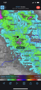
Severe thunderstorm warning…
Image
User avatar
Busguy2010
City Council
Posts: 7380
Joined: Sun Apr 10, 2011 12:32 am
Location: North Central Omaha

Re: 2021 Weather thread-

Post by Busguy2010 »

Always on the lowest chances too. Like W T F. Looks like it mostly is staying west of 680. Where I'm at its doing nothing right now, but I'm sure out there it is raining cats and dogs and may have decent sized hail. We'll see if it moves over into my neck of the woods.
User avatar
Omaha Cowboy
The Don
Posts: 1013731
Joined: Wed Jan 07, 2004 11:31 am
Location: West Omaha

Re: 2021 Weather thread-

Post by Omaha Cowboy »

Raining pretty heavily with plenty of thunder in my neck of the woods: 120th-132nd and West Center Rd area…

Ciao..LiO…Peace
Go Cowboys!
User avatar
stormchaser
Planning Board
Posts: 2380
Joined: Fri Jun 01, 2018 1:14 pm

Re: 2021 Weather thread-

Post by stormchaser »

Gotta love trying to forecast capping. I noticed 700mb temps had cooled to 12C and wondered if something might fire. Then some agitated cumulus formed like last night but I figured last night it was similar and that cap held. Tonight, it instead went boom. Forecasting the cap will drive a person nuts…
User avatar
stormchaser
Planning Board
Posts: 2380
Joined: Fri Jun 01, 2018 1:14 pm

Re: 2021 Weather thread-

Post by stormchaser »

A damaging wind event is "possible" in the Omaha area tonight...

Short-range and medium-range model guidance is at least hinting at some potential for damaging wind to come through the Omaha area tonight. It's going to depend on if the storms expected west of here maintain their strength enough as they push toward our area. If it happens, it looks like it will probably be sometime between 10 PM and 1 AM.
User avatar
Busguy2010
City Council
Posts: 7380
Joined: Sun Apr 10, 2011 12:32 am
Location: North Central Omaha

Re: 2021 Weather thread-

Post by Busguy2010 »

I don't really know how last night's storm went... It was fizzling out right as I was falling asleep, and it seemed like nothing more than the outflow boundary came through, with a little bit of wind gusts and some rain... Correct me if wrong.

But what I'm really excited about is that for the forecast period, there will not be a day reaching 90!!! :banana: And the temperatures have been trending down. Now looking like lower 80's most of the days with upper 80's later in the week.
User avatar
stormchaser
Planning Board
Posts: 2380
Joined: Fri Jun 01, 2018 1:14 pm

Re: 2021 Weather thread-

Post by stormchaser »

Busguy2010 wrote: Sun Aug 29, 2021 3:50 pm I don't really know how last night's storm went... It was fizzling out right as I was falling asleep, and it seemed like nothing more than the outflow boundary came through, with a little bit of wind gusts and some rain... Correct me if wrong.

But what I'm really excited about is that for the forecast period, there will not be a day reaching 90!!! :banana: And the temperatures have been trending down. Now looking like lower 80's most of the days with upper 80's later in the week.
Correct, it died out west of Fremont - good soaking rain though. And I agree, looking forward to the more reasonable temps.

Additional severe weather is possible in the area tomorrow night (after dark) with potential for heavy rain/localized flooding…
User avatar
Busguy2010
City Council
Posts: 7380
Joined: Sun Apr 10, 2011 12:32 am
Location: North Central Omaha

Re: 2021 Weather thread-

Post by Busguy2010 »

Wowza, according to NWS, they currently think it'll rain 2.5" starting basically at sunrise tomorrow and not letting up til noon Tuesday. The whole of Monday looks to be a washout. Fine by me. And really encouraging is every time I check the forecast, they keep tacking on low 80's at the end of it. I kinda think we may have seen the last of our persistently hot weather. Thank God. Might not even break 80 tomorrow.
User avatar
stormchaser
Planning Board
Posts: 2380
Joined: Fri Jun 01, 2018 1:14 pm

Re: 2021 Weather thread-

Post by stormchaser »

Busguy2010 wrote: Mon Aug 30, 2021 1:42 am Wowza, according to NWS, they currently think it'll rain 2.5" starting basically at sunrise tomorrow and not letting up til noon Tuesday. The whole of Monday looks to be a washout. Fine by me. And really encouraging is every time I check the forecast, they keep tacking on low 80's at the end of it. I kinda think we may have seen the last of our persistently hot weather. Thank God. Might not even break 80 tomorrow.
It's interesting, short-range models aren't really showing any precip at all in the Omaha area until Monday night sometime after Midnight at which time a pretty healthy damaging wind/hail event is possible in the area followed by heavy rain - possibly in excess of 2". I'm not saying the NWS is wrong as obviously they know way more than I do but it will be interesting to see how things play out anyway...
User avatar
Busguy2010
City Council
Posts: 7380
Joined: Sun Apr 10, 2011 12:32 am
Location: North Central Omaha

Re: 2021 Weather thread-

Post by Busguy2010 »

stormchaser wrote: Mon Aug 30, 2021 2:00 am It's interesting, short-range models aren't really showing any precip at all in the Omaha area until Monday night sometime after Midnight at which time a pretty healthy damaging wind/hail event is possible in the area followed by heavy rain - possibly in excess of 2". I'm not saying the NWS is wrong as obviously they know way more than I do but it will be interesting to see how things play out anyway...
Bill Randby pretty much just confirmed that. Little rail Monday, followed by a pretty strong system moving through in the early morning on Tuesday, with a prolonged rain event following...

I'm personally sick of the late night/early morning severe storms... If it will happen anyway, I would greatly prefer it to happen at 3p to dark. It seems like every notable storm that has happened this year has happened after dark and on a Friday or Saturday. Weird. I guess beggars can't be choosers.
This season has been quite active, I just haven't cared for the timing of our notable storms.
User avatar
stormchaser
Planning Board
Posts: 2380
Joined: Fri Jun 01, 2018 1:14 pm

Re: 2021 Weather thread-

Post by stormchaser »

Busguy2010 wrote: Mon Aug 30, 2021 3:32 am
stormchaser wrote: Mon Aug 30, 2021 2:00 am It's interesting, short-range models aren't really showing any precip at all in the Omaha area until Monday night sometime after Midnight at which time a pretty healthy damaging wind/hail event is possible in the area followed by heavy rain - possibly in excess of 2". I'm not saying the NWS is wrong as obviously they know way more than I do but it will be interesting to see how things play out anyway...
Bill Randby pretty much just confirmed that. Little rail Monday, followed by a pretty strong system moving through in the early morning on Tuesday, with a prolonged rain event following...

I'm personally sick of the late night/early morning severe storms... If it will happen anyway, I would greatly prefer it to happen at 3p to dark. It seems like every notable storm that has happened this year has happened after dark and on a Friday or Saturday. Weird. I guess beggars can't be choosers.
This season has been quite active, I just haven't cared for the timing of our notable storms.
I hear you - lots of late-night wind producers, especially as of late. Would be nice if it didn't get so hot during the day that storms would have a better chance of forming during the day. Maybe in the next few weeks as things start to cool off again we will get a more active stretch of daytime storms...maybe.
User avatar
stormchaser
Planning Board
Posts: 2380
Joined: Fri Jun 01, 2018 1:14 pm

Re: 2021 Weather thread-

Post by stormchaser »

Lots of uncertainty with the forecast for today/tonight...

Potential storms round 1 (evening hail producers) - less likely to happen:
Storms "might" develop late this afternoon or early evening in northeast NE and move southeast - possibly toward Omaha but most likely remain north of here. If they do develop, large hail would be the main threat. Just to stress, odds of this scenario playing out have been decreasing though it's something to be aware of.

Also if storms do develop, it will probably decrease the chance for severe weather in the Omaha area late tonight as the atmosphere would need to recover in time (the second round of storms is expected to develop in the Dakotas this afternoon/evening and move south/southeast toward us - which would bring them through northeast NE and the area with earlier storms which may weaken them).

Potential storms round 2 (damaging wind event) - most likely to happen:
If storms fail to develop in northeast NE, then a damaging wind threat in Omaha is more likely late tonight. This is by far the most likely scenario IMO.

In addition to a severe weather threat, flooding may be a concern in some areas - especially given the potential of training storms. Sounds like the NWS is probably going to issue a flood watch but are waiting for a bit more certainty before they do so...

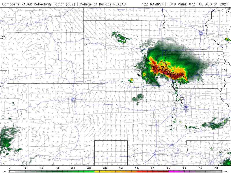
Simulated Radar:
Below is a still image of the simulated radar for both the 12z HRRR and 3km NAM forecast models.

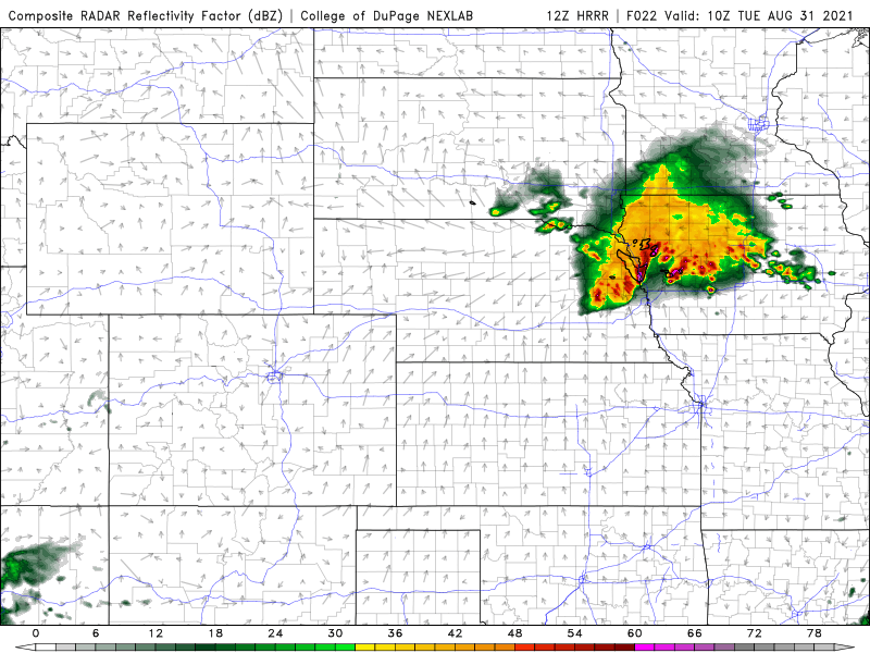
12z HRRR (Showing potential damaging wind hitting Omaha around 4 AM as storms move southeast into the area):
Image

3km NAM (Showing potential damaging wind hitting Omaha around 1 AM as storms move south/southeast into the area):
Image
User avatar
stormchaser
Planning Board
Posts: 2380
Joined: Fri Jun 01, 2018 1:14 pm

Re: 2021 Weather thread-

Post by stormchaser »

A weather watch will probably be needed soon for parts of southern SD and northern NE (downstream from the current watch in parts of SD). These will be the storms that will eventually move into the Omaha area late tonight (after Midnight) and produce the potential for damaging wind/hail in the area (in addition to a localized flooding threat).

More info:
https://www.spc.noaa.gov/products/md/md1655.html
User avatar
Busguy2010
City Council
Posts: 7380
Joined: Sun Apr 10, 2011 12:32 am
Location: North Central Omaha

Re: 2021 Weather thread-

Post by Busguy2010 »

We are definitely the focus area tonight...

Image
User avatar
Brad
Photographer
Posts: 1036693
Joined: Sun Feb 29, 2004 12:03 am
Location: Omaha, NE

Re: 2021 Weather thread-

Post by Brad »

Looks like tonight's storms are finally getting going on the NE/SD border in Cherry County and also long I90 near Chamberlin.
User avatar
stormchaser
Planning Board
Posts: 2380
Joined: Fri Jun 01, 2018 1:14 pm

Re: 2021 Weather thread-

Post by stormchaser »

Brad wrote: Tue Aug 31, 2021 2:29 am Looks like tonight's storms are finally getting going on the NE/SD border in Cherry County and also long I90 near Chamberlin.
Yep, multiple severe warned storms (mostly for hail) in northeast NE now.

Storms are expected to grow upscale into more of a damaging wind threat (with some large hail) over the next few hours as they eventually make their way into Omaha.

Unfortunately this looks like it could be a fairly damaging event for the local area if short-range models verify…
User avatar
Busguy2010
City Council
Posts: 7380
Joined: Sun Apr 10, 2011 12:32 am
Location: North Central Omaha

Re: 2021 Weather thread-

Post by Busguy2010 »

Very solid severe storms up north right now. They seem closer right now than 3, 4, 5am, but I'm probably wrong. I just hope it ain't too windy, I've got one lone remaining sunflower and it is heavy and ripening. If it makes it through this one, I think I stand a chance to get a good head of seeds.
User avatar
stormchaser
Planning Board
Posts: 2380
Joined: Fri Jun 01, 2018 1:14 pm

Re: 2021 Weather thread-

Post by stormchaser »

Busguy2010 wrote: Tue Aug 31, 2021 4:35 am Very solid severe storms up north right now. They seem closer right now than 3, 4, 5am, but I'm probably wrong. I just hope it ain't too windy, I've got one lone remaining sunflower and it is heavy and ripening. If it makes it through this one, I think I stand a chance to get a good head of seeds.
Yeah, they are definitely ahead of schedule by a couple hours…
User avatar
stormchaser
Planning Board
Posts: 2380
Joined: Fri Jun 01, 2018 1:14 pm

Re: 2021 Weather thread-

Post by stormchaser »

Wind shouldn’t be as bad as it was in July, but wind-driven hail is possible (some hail could be fairly large) so if that happens, it will be a mess…
User avatar
stormchaser
Planning Board
Posts: 2380
Joined: Fri Jun 01, 2018 1:14 pm

Re: 2021 Weather thread-

Post by stormchaser »

Thankfully it didn't end up as bad as it could have been. Hail died off mostly before it got to Omaha. We had some wind but I haven't seen much damage this time.

The next chance at potential strong/severe storms and possibly heavy rain again is this coming Thursday...
User avatar
Busguy2010
City Council
Posts: 7380
Joined: Sun Apr 10, 2011 12:32 am
Location: North Central Omaha

Re: 2021 Weather thread-

Post by Busguy2010 »

I was basically in and out of sleep as it showed up. Wind didn't seem all too bad, but the rain sounded amazing. There were a few pretty close CG strikes, but it wasn't all that dense.
User avatar
Busguy2010
City Council
Posts: 7380
Joined: Sun Apr 10, 2011 12:32 am
Location: North Central Omaha

Re: 2021 Weather thread-

Post by Busguy2010 »

2.64" of rain last night... Really can't ask for better than that! Plus it happened on the final day of the month, so with that, for the second consecutive month, we will end with a surplus. Currently at 5.31" on the month, and that is despite Eppley recording lower amounts than the rest of the metro seemingly all month. Still a small chance of rain yet today, so I will wait on my report. All I know is the last two months have been amazing in the moisture department.
User avatar
skinzfan23
City Council
Posts: 11667
Joined: Mon Feb 09, 2004 5:26 pm
Location: Omaha/Bellevue

Re: 2021 Weather thread-

Post by skinzfan23 »

We got 3.3" SW of Bellevue.
User avatar
stormchaser
Planning Board
Posts: 2380
Joined: Fri Jun 01, 2018 1:14 pm

Re: 2021 Weather thread-

Post by stormchaser »

Radar estimated rain totals (usually fairly accurate).

Places between Gretna and Elkhorn likely got over 4” of rain…


Image
User avatar
Brad
Photographer
Posts: 1036693
Joined: Sun Feb 29, 2004 12:03 am
Location: Omaha, NE

Re: 2021 Weather thread-

Post by Brad »

stormchaser wrote: Tue Aug 31, 2021 6:09 pm Radar estimated rain totals (usually fairly accurate).

Places between Gretna and Elkhorn likely got over 4” of rain…
I saw on the NWS twitter, the area of 204th and Q had 6.5 inches.
User avatar
stormchaser
Planning Board
Posts: 2380
Joined: Fri Jun 01, 2018 1:14 pm

Re: 2021 Weather thread-

Post by stormchaser »

Brad wrote: Tue Aug 31, 2021 6:23 pm
stormchaser wrote: Tue Aug 31, 2021 6:09 pm Radar estimated rain totals (usually fairly accurate).

Places between Gretna and Elkhorn likely got over 4” of rain…
I saw on the NWS twitter, the area of 204th and Q had 6.5 inches.
Wow, that's pretty crazy!
User avatar
stormchaser
Planning Board
Posts: 2380
Joined: Fri Jun 01, 2018 1:14 pm

Re: 2021 Weather thread-

Post by stormchaser »

Looking like another after-dark event in the Omaha area tomorrow night with damaging wind/hail the primary threat though an isolated tornado can’t be ruled out. At least this time it probably won’t be after Midnight in Omaha…hopefully. The HRRR is even showing at least "some" severe weather potential not far to our west/northwest (near Columbus/Norfolk) around 5 or 6. So I guess we will see anyway.
User avatar
stormchaser
Planning Board
Posts: 2380
Joined: Fri Jun 01, 2018 1:14 pm

Re: 2021 Weather thread-

Post by stormchaser »

Probably chasing today - preliminary target is in the York, Hastings, Grand Island area. Tornado potential will be contingent on the ongoing convection moving in from the west dying out and the atmosphere recovering in time. Based on short range model trends, it will - but only time will tell.

Otherwise odds for severe weather in Omaha itself are increasing. I realize the SPC has the risk area mostly to our west but multiple runs of the HRRR short range model are showing storms hanging on long enough to impact Omaha (sometime between 8 PM and Midnight). If this happens, damaging wind and hail will be the primary threats. Don’t be surprised if the SPC expands the risk area east to include Omaha if model trends continue.
User avatar
Busguy2010
City Council
Posts: 7380
Joined: Sun Apr 10, 2011 12:32 am
Location: North Central Omaha

Re: 2021 Weather thread-

Post by Busguy2010 »

The latest run KETV just showed didnt have nearly the density of last night's run. According to them, it doesnt look like much of a damaging wind event anymore, but they are still talking 1-3" of rain. This is for the Omaha metro itself, I understand out west might be a little more interesting, but it sounds like Omaha itself will not get it all that bad other than heavy rain and some flooding.
User avatar
stormchaser
Planning Board
Posts: 2380
Joined: Fri Jun 01, 2018 1:14 pm

Re: 2021 Weather thread-

Post by stormchaser »

It depends on how quickly storm intensity starts to weaken. If it doesn't hit Omaha, it will definitely be not far from here (odds increase the further west you go).

The latest HRRR shows potential hail/damaging wind in the area. Odds aren't great that it will hit Omaha itself but from Lincoln up towards Fremont on west, odds are pretty good. In Omaha itself, there is a chance but it's a toss-up if it will happen here or not (no way to tell for sure how quickly storms will weaken). Either way, lots of heavy rain - some places will probably exceed 3" of rain not far from here...
User avatar
stormchaser
Planning Board
Posts: 2380
Joined: Fri Jun 01, 2018 1:14 pm

Re: 2021 Weather thread-

Post by stormchaser »

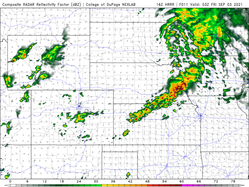
Latest simulated radar from the HRRR.The pinks and the black outlined areas represent hail (just west of Omaha in the image). This is for around 8 or 9 PM so I guess we will see...

Image
Louie
County Board
Posts: 4963
Joined: Fri Dec 23, 2011 10:23 pm
Location: Dundee

Re: 2021 Weather thread-

Post by Louie »

Hopefully the hail stays south of the metro. Does still look like some great rain totals for that round. With a possible briefer round of rain at about 4pm to add to it.
User avatar
stormchaser
Planning Board
Posts: 2380
Joined: Fri Jun 01, 2018 1:14 pm

Re: 2021 Weather thread-

Post by stormchaser »

Then again, I think the current precip that moved into Omaha has moved in slower than expected. I'm guessing this will ruin our environment locally in Omaha for much severe weather. Maybe a few stronger storms still but nothing too crazy I'm sure. Most of the fun stuff will be well west of here...
User avatar
Busguy2010
City Council
Posts: 7380
Joined: Sun Apr 10, 2011 12:32 am
Location: North Central Omaha

Re: 2021 Weather thread-

Post by Busguy2010 »

The sun is coming out though so that could help. I admit I have tempered expectations with this one, but I think it'll deliver on the rain. Maybe not quite like the last one, but still healthy.
User avatar
Brad
Photographer
Posts: 1036693
Joined: Sun Feb 29, 2004 12:03 am
Location: Omaha, NE

Re: 2021 Weather thread-

Post by Brad »

Tornado warning out by Kearney and a watch a little closer to the metro, but not including the metro.
User avatar
stormchaser
Planning Board
Posts: 2380
Joined: Fri Jun 01, 2018 1:14 pm

Re: 2021 Weather thread-

Post by stormchaser »

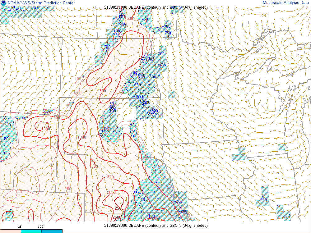
The main issue in the Omaha area is the lack of instability and too much inhibition currently in the area - and since we are past peak heating, and it will get dark in a couple of hours, it will be difficult to get enough instability for much severe weather locally.

Still think there is a chance for a few strong/marginally severe storms in the area, but mostly heavy rain with thunder…

Current surface based CAPE (aka convective available potential energy):
Image
Last edited by stormchaser on Fri Sep 03, 2021 12:24 am, edited 1 time in total.
User avatar
Omaha Cowboy
The Don
Posts: 1013731
Joined: Wed Jan 07, 2004 11:31 am
Location: West Omaha

Re: 2021 Weather thread-

Post by Omaha Cowboy »

Hopefully we have a dry Friday…

Ciao..LiO…Peace
Go Cowboys!