Yep, it all be interesting - unless things completely change (which of course is always possible). If it doesn’t change though, look out…Busguy2010 wrote: Sat Dec 11, 2021 7:29 pm I can't wait to see the US convective outlook on that. If what you're saying turns out, I'd be very interested to what level of severe risk they give us.
2021 Weather thread-
-
stormchaser

- Planning Board
- Posts: 2380
- Joined: Fri Jun 01, 2018 8:14 am
Re: 2021 Weather thread-
-
stormchaser
- Planning Board
- Posts: 2380
- Joined: Fri Jun 01, 2018 8:14 am
Re: 2021 Weather thread-
…since it’s a fairly small area at risk, they may not go higher than a “slight risk” though.
-
Omaha Cowboy

- The Don
- Posts: 1013719
- Joined: Wed Jan 07, 2004 5:31 am
- Location: West Omaha
Re: 2021 Weather thread-
It might be interesting to research..because I can’t remember, in my lifetime, there ever being a tornado threat for eastern Nebraska this late into the year…stormchaser wrote: Sun Dec 12, 2021 4:10 am …since it’s a fairly small area at risk, they may not go higher than a “slight risk” though.
Ciao..LiO…Peace
Go Cowboys!
-
Busguy2010

- City Council
- Posts: 7328
- Joined: Sat Apr 09, 2011 7:32 pm
- Location: North Central Omaha
Re: 2021 Weather thread-
I can certainly see why there would be a risk for severe weather. NWS has the high at 72 and the low that night at 29. I would assume the temperature gradient will be pretty significant upon arrival of the front/storms.
Golly! And they've got almost 60 mph wind gusts for it too Yikes.
Golly! And they've got almost 60 mph wind gusts for it too
 Yikes.
-
stormchaser
- Planning Board
- Posts: 2380
- Joined: Fri Jun 01, 2018 8:14 am
Re: 2021 Weather thread-
The GFS and ECMWF continue to show severe weather potential. The NAM, however, is depicting lower dewpoints, lower high temps, and very little in the way of instability. If the NAM verifies, not much of anything will probably happen for storms on Wednesday. If the GFS or ECMWF verifies, then severe weather looks relatively likely.
Will be interesting to see what temps/dewpoints/instability actually end up being. Not sure how well models are handling this potential setup since this isn't the type of thing that happens this time of year very often (obviously)...
Will be interesting to see what temps/dewpoints/instability actually end up being. Not sure how well models are handling this potential setup since this isn't the type of thing that happens this time of year very often (obviously)...
-
Omaha Cowboy
- The Don
- Posts: 1013719
- Joined: Wed Jan 07, 2004 5:31 am
- Location: West Omaha
Re: 2021 Weather thread-
I pray that it’s a stable, warm, 70 degree type of day Wednesday with little to no severe weather potential..
The Tornado outbreak this weekend, with all the death and destruction it caused was absolutely sickening to see…
Ciao..LiO…Peace
The Tornado outbreak this weekend, with all the death and destruction it caused was absolutely sickening to see…
Ciao..LiO…Peace
Go Cowboys!
-
stormchaser
- Planning Board
- Posts: 2380
- Joined: Fri Jun 01, 2018 8:14 am
Re: 2021 Weather thread-
I agree - absolutely terrible what happened there.Omaha Cowboy wrote: Sun Dec 12, 2021 11:28 pm I pray that it’s a stable, warm, 70 degree type of day Wednesday with little to no severe weather potential..
The Tornado outbreak this weekend, with all the death and destruction it caused was absolutely sickening to see…
Ciao..LiO…Peace
Forecast models remain unchanged this morning. If the ECMWF and GFS verify, damaging wind and potential tornadoes. If the NAM verifies, maybe no storms at all (due to lack of instability).
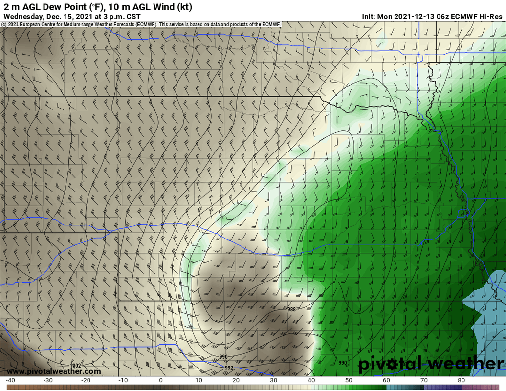
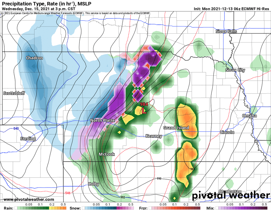
At this point, I'm factoring out the NAM simply because it's the "odd man out" and instead favoring what the GFS and ECMWF show (both are very similar). Below are a few images from the 00z ECMWF. It shows tornado/severe weather potential in eastern NE from mid-afternoon into the evening hours (though things will push through very fast and would be done in our local area quickly). To be clear, this does not mean this will happen. It just means models are currently showing potential.
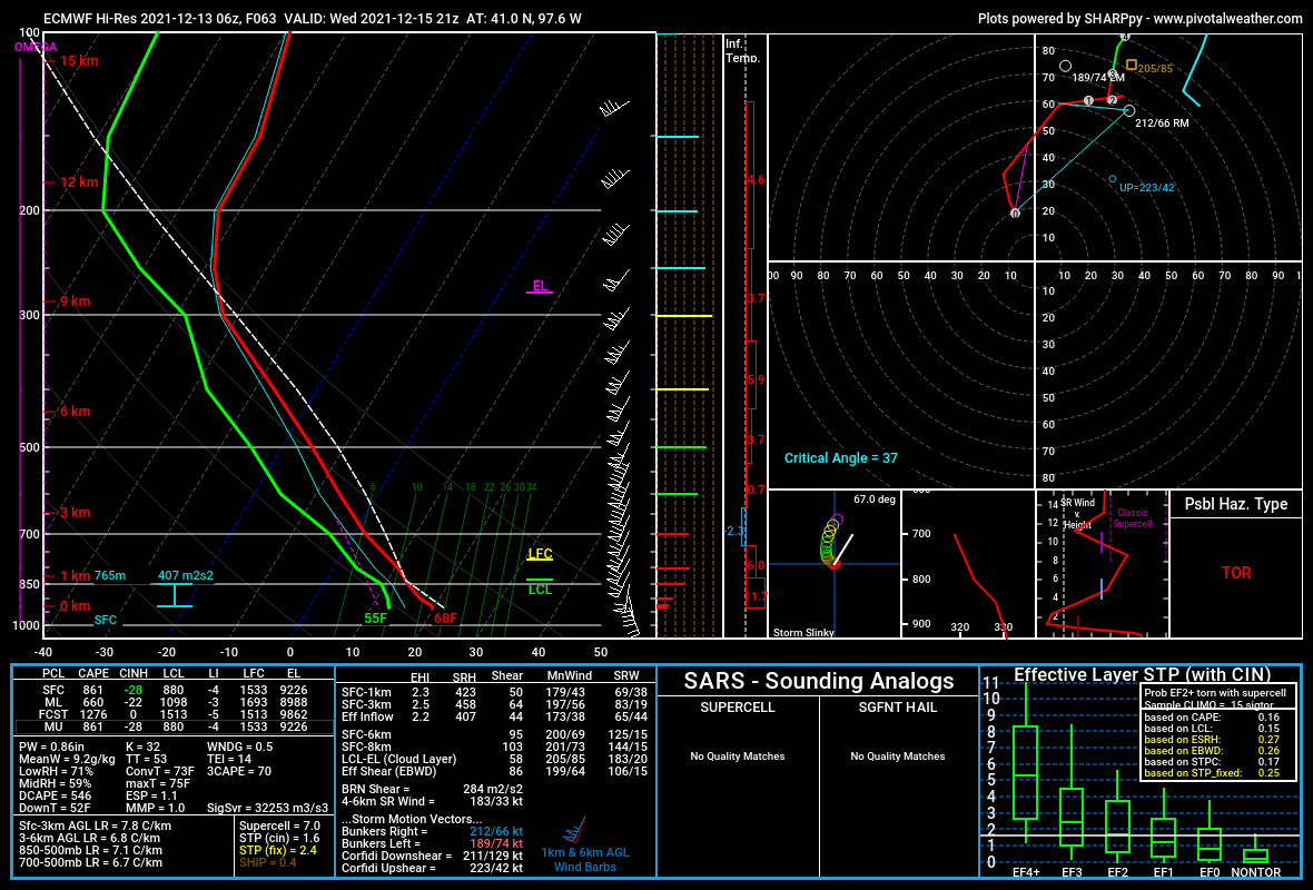
The below images are for 3 PM. It shows a forecast sounding for near the York, NE area which shows tornado potential (this risk area would push through Omaha itself around 5 PM if this verifies). Wind profiles are actually more favorable now for tornado potential than they had been on previous model runs (showing more southeasterly at low levels which is increasing the low-level helicity and consequently tornado potential). The depicted dewpoints in the mid-50s are pretty marginal though and may limit potential (it's unclear). If dewpoints end up lower than this, we may dodge a bullet.
Both the ECMWF and GFS show CAPE values between 600 and 900 J/kg which would be sufficient this time of year for severe storm development. However, it is unclear if that would be enough for storms to sustain themselves given the strong shear values (storms may get ripped apart by the strength of the shear). If the shear rips storms apart, expect them to pulse up and then weaken nearly as fast before pulsing up again - but they wouldn't reach their full potential if this happens.
Anyhow, here are the images from the 00z ECMWF for 21z (3 PM).
Forecast sounding for near York, NE showing the tornado potential:
Depicted dewpoints in the mid-50s with a wedge of dry air wrapping in from the southwest which would trigger storm initiation:
Simulated radar showing convective development at 3 PM (possibly supercellular?):
-
Coyote

- City Council
- Posts: 34366
- Joined: Tue Nov 18, 2003 11:18 am
- Location: Aksarben Village
Re: 2021 Weather thread-
Pine-Apple express?
-
Brad

- Photographer
- Posts: 1036562
- Joined: Sat Feb 28, 2004 6:03 pm
- Location: Omaha, NE
Re: 2021 Weather thread-
So how does the time of year change the instability (CAPE) requirements? If it was May and you had CAPE under 1000, nobody would even look at it, correct? Seems like a lot of chasers don't get excited until the CAPE is north of 2000 or 3000.

Omaha Skyline Photos, Omaha Aerial Photos, and More.
Website: www.bradwilliamsphotography.com
Facebook: www.facebook.com/bradwilliamsphotography
Twitter: www.twitter.com/bradwphoto
Instagram: www.instagram.com/bradwilliamsphotography
YouTube: www.youtube.com/@bradwilliamsphoto
-
stormchaser
- Planning Board
- Posts: 2380
- Joined: Fri Jun 01, 2018 8:14 am
Re: 2021 Weather thread-
Actually, it changes the required CAPE values a lot this time of year. Really, anything above 500 would likely be sufficient for storm development this time of year in most cases. During mid-summer, you end up with more warm air aloft which adds capping to the environment. You need enough instability to help with the forcing to push through any capping that may be in place. This time of year, you don't have the same warm air aloft so you really don't need much instability for convective development.Brad wrote: Mon Dec 13, 2021 8:31 am So how does the time of year change the instability (CAPE) requirements? If it was May and you had CAPE under 1000, nobody would even look at it, correct? Seems like a lot of chasers don't get excited until the CAPE is north of 2000 or 3000.
The biggest issues this time of year (and early Spring really) are often dewpoints and "moisture depth". You typically get very strong cold fronts this time of year making it difficult for sufficient moisture to make it this far north before a strong cold front clears things out. This is especially true with "moisture depth" (aka moisture aloft - not just at the surface).
-
stormchaser
- Planning Board
- Posts: 2380
- Joined: Fri Jun 01, 2018 8:14 am
Re: 2021 Weather thread-
Yep, definitely looking like an active weather pattern - that's for sure

-
Brad
- Photographer
- Posts: 1036562
- Joined: Sat Feb 28, 2004 6:03 pm
- Location: Omaha, NE
Re: 2021 Weather thread-
stormchaser wrote: Mon Dec 13, 2021 8:39 am Actually, it changes the required CAPE values a lot this time of year. Really, anything above 500 would likely be sufficient for storm development this time of year in most cases. During mid-summer, you end up with more warm air aloft which adds capping to the environment. You need enough instability to help with the forcing to push through any capping that may be in place. This time of year, you don't have the same warm air aloft so you really don't need much instability for convective development.
Thanks, That makes sense. I guess I haven't ever looked at the amount of instability this time of year.
Omaha Skyline Photos, Omaha Aerial Photos, and More.
Website: www.bradwilliamsphotography.com
Facebook: www.facebook.com/bradwilliamsphotography
Twitter: www.twitter.com/bradwphoto
Instagram: www.instagram.com/bradwilliamsphotography
YouTube: www.youtube.com/@bradwilliamsphoto
-
stormchaser
- Planning Board
- Posts: 2380
- Joined: Fri Jun 01, 2018 8:14 am
Re: 2021 Weather thread-
No problem!Brad wrote: Mon Dec 13, 2021 8:48 amstormchaser wrote: Mon Dec 13, 2021 8:39 am Actually, it changes the required CAPE values a lot this time of year. Really, anything above 500 would likely be sufficient for storm development this time of year in most cases. During mid-summer, you end up with more warm air aloft which adds capping to the environment. You need enough instability to help with the forcing to push through any capping that may be in place. This time of year, you don't have the same warm air aloft so you really don't need much instability for convective development.
Thanks, That makes sense. I guess I haven't ever looked at the amount of instability this time of year.
It's worth mentioning that there will probably be 60+ mph wind gusts in our area on Wednesday even if we don't get storms...
-
Cermak
- Planning Board
- Posts: 2331
- Joined: Thu Nov 29, 2018 1:02 pm
Re: 2021 Weather thread-
Not sure if I recall us ever having 60 mph winds in December, maybe 40 or 50.
-
Busguy2010
- City Council
- Posts: 7328
- Joined: Sat Apr 09, 2011 7:32 pm
- Location: North Central Omaha
Re: 2021 Weather thread-
I'm sure it has. Probably more in the form of a blizzard. But yeah, this one is gonna be weird.Cermak wrote: Mon Dec 13, 2021 11:14 am Not sure if I recall us ever having 60 mph winds in December, maybe 40 or 50.
The possibility of thunderstorms kinda reminds me of that April 27th West Omaha Tornado. That tornado came out of nowhere and was about a 60 degree day. We may get up to 70 Wednesday. I'm just not sure the moisture is there.
-
stormchaser
- Planning Board
- Posts: 2380
- Joined: Fri Jun 01, 2018 8:14 am
Re: 2021 Weather thread-
Probably during a blizzard (like you said).Busguy2010 wrote: Mon Dec 13, 2021 11:29 amI'm sure it has. Probably more in the form of a blizzard. But yeah, this one is gonna be weird.Cermak wrote: Mon Dec 13, 2021 11:14 am Not sure if I recall us ever having 60 mph winds in December, maybe 40 or 50.
The possibility of thunderstorms kinda reminds me of that April 27th West Omaha Tornado. That tornado came out of nowhere and was about a 60 degree day. We may get up to 70 Wednesday. I'm just not sure the moisture is there.
This setup is a LOT like the setup that occurred with the November 12th, 2005 tornado outbreak in Iowa (which includes the Woodward, IA EF3 tornado) - just a month later and further west/southwest so it includes Nebraska and this time should be over a more localized area...that localized area, however, looks like it will include the Omaha area, unfortunately.
More info here: Moisture return, moisture depth, dewpoints, and actual instability will be key if we get tornadic storms. Right now it "looks" like we will but it's such an odd setup for this time of year, who knows.
-
stormchaser
- Planning Board
- Posts: 2380
- Joined: Fri Jun 01, 2018 8:14 am
Re: 2021 Weather thread-
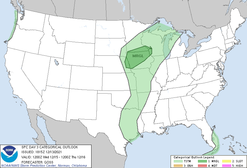
SPC has upgraded our area to a "marginal risk" for severe storms Wednesday. More than likely, that will also be upgraded to a "slight risk" (based on the included text) at some point tonight or tomorrow. Their concern is with damaging wind potential (which I don't disagree with) although I do feel they have the risk area too far east based on the 12z models. I also feel they are overlooking the tornado potential a bit. Of course, it will depend on actual dewpoints/instability and if wind profiles are more southeasterly at the surface, but still, the potential certainly exists at this point - especially early on as storms first fire and with anything that can remain discrete. Storm motions will be pretty insane though either way making chasing these nearly impossible (most will be moving at 50+mph)
-
stormchaser
- Planning Board
- Posts: 2380
- Joined: Fri Jun 01, 2018 8:14 am
Re: 2021 Weather thread-
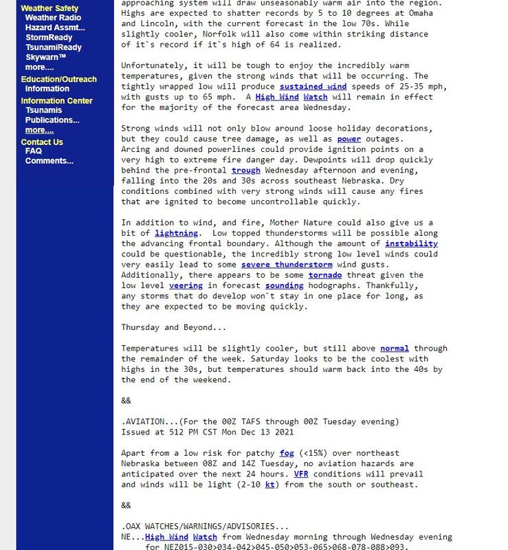
NWS Omaha warning of the potential severe weather/tornado threat for Wednesday (just so people don't think I'm insane - they see the threat too  ):
):
"In addition to wind, and fire, Mother Nature could also give us a bit of lightning. Low topped thunderstorms will be possible along the advancing frontal boundary. Although the amount of instability could be questionable, the incredibly strong low level winds could very easily lead to some severe thunderstorm wind gusts. Additionally, there appears to be some tornado threat given the low level veering in forecast sounding hodographs. Thankfully, any storms that do develop won`t stay in one place for long, as they are expected to be moving quickly."
Found here:
https://forecast.weather.gov/product.ph ... glossary=1
Took a screenshot for when the link above updates (so you can still see what I'm referring to):
):"In addition to wind, and fire, Mother Nature could also give us a bit of lightning. Low topped thunderstorms will be possible along the advancing frontal boundary. Although the amount of instability could be questionable, the incredibly strong low level winds could very easily lead to some severe thunderstorm wind gusts. Additionally, there appears to be some tornado threat given the low level veering in forecast sounding hodographs. Thankfully, any storms that do develop won`t stay in one place for long, as they are expected to be moving quickly."
Found here:
https://forecast.weather.gov/product.ph ... glossary=1
Took a screenshot for when the link above updates (so you can still see what I'm referring to):
-
Brad
- Photographer
- Posts: 1036562
- Joined: Sat Feb 28, 2004 6:03 pm
- Location: Omaha, NE
Re: 2021 Weather thread-
Its strange, everyone seems to be mentioning some remote possibility of a tornado, even the NWS is said there is a possibility of an isolated tornado. Tuned in to Channel 7 tonight and Randby never even mentioned the word Tornado. I know its probably a low chance, but since its December and people aren't expecting a tornado, you would think it would be good to mention it just incase?
Omaha Skyline Photos, Omaha Aerial Photos, and More.
Website: www.bradwilliamsphotography.com
Facebook: www.facebook.com/bradwilliamsphotography
Twitter: www.twitter.com/bradwphoto
Instagram: www.instagram.com/bradwilliamsphotography
YouTube: www.youtube.com/@bradwilliamsphoto
-
stormchaser
- Planning Board
- Posts: 2380
- Joined: Fri Jun 01, 2018 8:14 am
Re: 2021 Weather thread-
You would think. I mean, it’s a very conditional threat but still a threat.Brad wrote: Tue Dec 14, 2021 12:03 am Its strange, everyone seems to be mentioning some remote possibility of a tornado, even the NWS is said there is a possibility of an isolated tornado. Tuned in to Channel 7 tonight and Randby never even mentioned the word Tornado. I know its probably a low chance, but since its December and people aren't expecting a tornado, you would think it would be good to mention it just incase?
That said, the SPC continues to favor faster timing and pushes the low/front through eastern NE sooner so storm potential would be northeast of here if that happens (they have a slight risk now in northwest IA). I’m not sold that things will push through this fast but it’s possible Omaha will dodge a bullet as a result of timing. Guess we will see what model trends show…
-
stormchaser
- Planning Board
- Posts: 2380
- Joined: Fri Jun 01, 2018 8:14 am
Re: 2021 Weather thread-
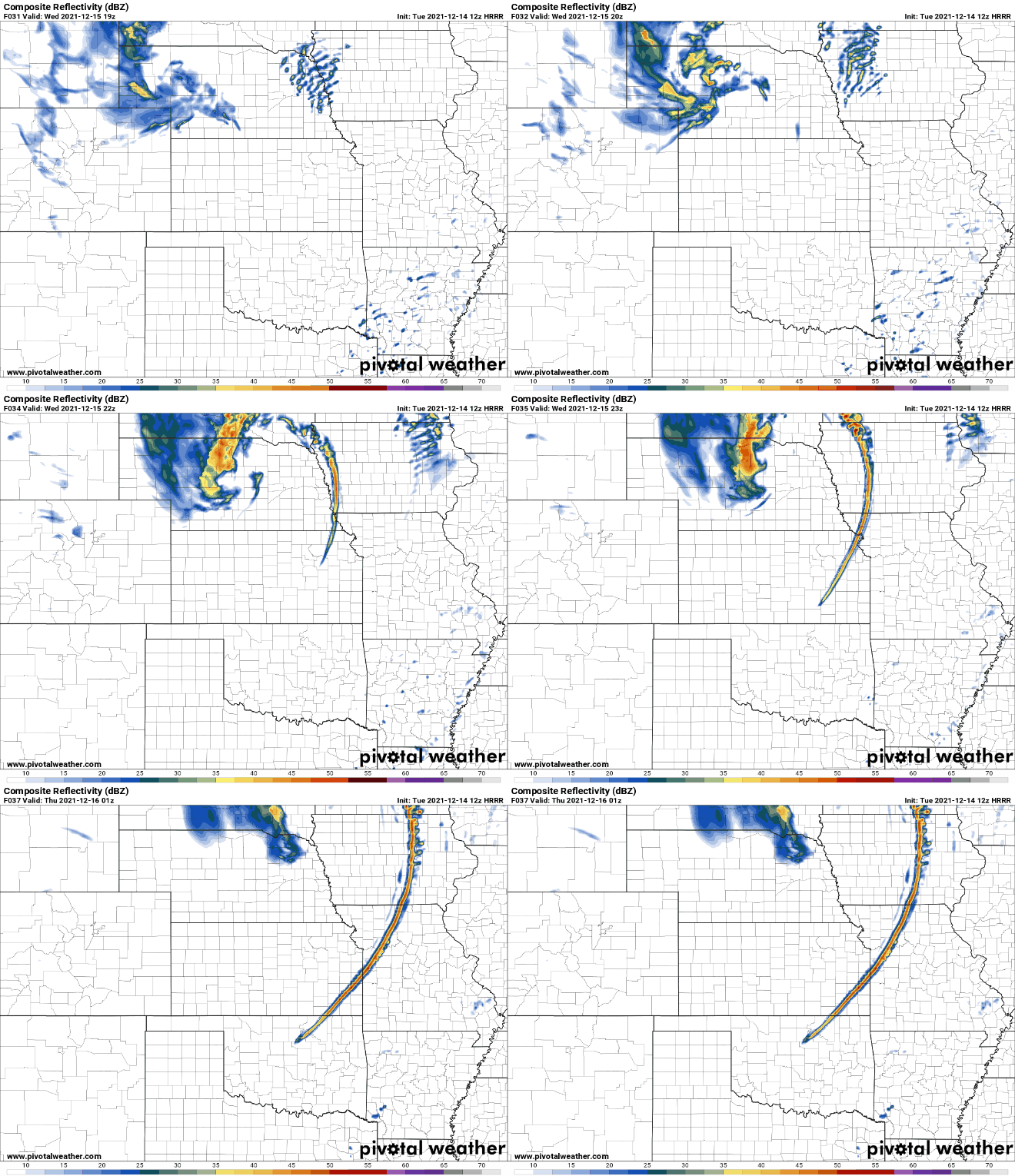
Looks like the primary risk in Omaha will be around 3 PM with mostly a damaging wind threat (though an isolated tornado can't be ruled out).
Storms should start developing around 1 PM in parts of northeast NE and back build to the southeast. The most favorable area for tornadoes is north of Omaha from parts of far northeastern NE into northwest IA including the Sioux City area up into far southern MN and north-central IA where surface winds are expected to be more southeasterly and storms will probably be more isolated.
Below is a simulated radar loop from the 12z HRRR forecast model starting at about Noon tomorrow and showing the storms as they develop west of Omaha and quickly move through town around 3 PM (assuming they develop in time). If they do, we will have a very brief period of storms that will basically be done in a blink of an eye but could produce some damaging wind in the area...but still pretty crazy for this time of year.
I'd be surprised if there aren't a few tornado reports tomorrow (at the very least funnel clouds) - mostly in parts of northern IA though. The biggest story locally anyway will be the wind gusts throughout much of the day - some may approach or exceed hurricane strength (74+mph)...
Storms should start developing around 1 PM in parts of northeast NE and back build to the southeast. The most favorable area for tornadoes is north of Omaha from parts of far northeastern NE into northwest IA including the Sioux City area up into far southern MN and north-central IA where surface winds are expected to be more southeasterly and storms will probably be more isolated.
Below is a simulated radar loop from the 12z HRRR forecast model starting at about Noon tomorrow and showing the storms as they develop west of Omaha and quickly move through town around 3 PM (assuming they develop in time). If they do, we will have a very brief period of storms that will basically be done in a blink of an eye but could produce some damaging wind in the area...but still pretty crazy for this time of year.
I'd be surprised if there aren't a few tornado reports tomorrow (at the very least funnel clouds) - mostly in parts of northern IA though. The biggest story locally anyway will be the wind gusts throughout much of the day - some may approach or exceed hurricane strength (74+mph)...
-
Coyote
- City Council
- Posts: 34366
- Joined: Tue Nov 18, 2003 11:18 am
- Location: Aksarben Village
-
Louie
- County Board
- Posts: 4936
- Joined: Fri Dec 23, 2011 4:23 pm
- Location: Dundee
Re: 2021 Weather thread-
Oh god, tomorrow is trash day for me 
-
Busguy2010
- City Council
- Posts: 7328
- Joined: Sat Apr 09, 2011 7:32 pm
- Location: North Central Omaha
Re: 2021 Weather thread-
Wow, tomorrows gonna suck.
-
stormchaser
- Planning Board
- Posts: 2380
- Joined: Fri Jun 01, 2018 8:14 am
Re: 2021 Weather thread-
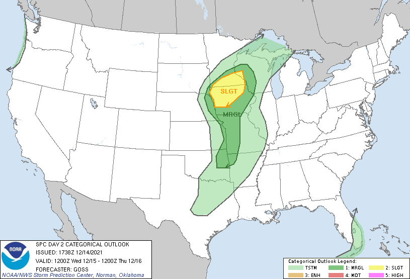
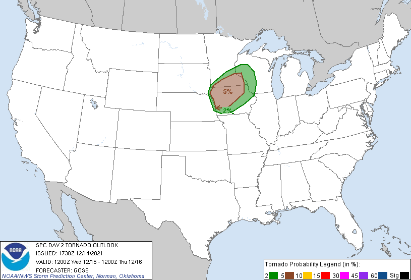
SPC updated the severe weather and tornado risk for tomorrow. Now a slight risk is just barely east of Omaha with a 5% tornado threat.
Initiation will probably be close to Omaha so we may or may not get hit but it's close enough people need to watch closely mid-afternoon tomorrow...
Initiation will probably be close to Omaha so we may or may not get hit but it's close enough people need to watch closely mid-afternoon tomorrow...
-
Brad
- Photographer
- Posts: 1036562
- Joined: Sat Feb 28, 2004 6:03 pm
- Location: Omaha, NE
Re: 2021 Weather thread-
I've seen it all now...
Omaha Skyline Photos, Omaha Aerial Photos, and More.
Website: www.bradwilliamsphotography.com
Facebook: www.facebook.com/bradwilliamsphotography
Twitter: www.twitter.com/bradwphoto
Instagram: www.instagram.com/bradwilliamsphotography
YouTube: www.youtube.com/@bradwilliamsphoto
-
skinzfan23

- City Council
- Posts: 11629
- Joined: Mon Feb 09, 2004 11:26 am
- Location: Omaha/Bellevue

-
skinzfan23
- City Council
- Posts: 11629
- Joined: Mon Feb 09, 2004 11:26 am
- Location: Omaha/Bellevue
Re: 2021 Weather thread-
Just got the message that Bellevue is cancelling school tomorrow due to the weather.
-
jag42
- Human Relations
- Posts: 543
- Joined: Sat Mar 14, 2009 1:29 pm
- Location: Omaha Metro Area
Re: 2021 Weather thread-
My only guess is they don't want to risk busses full of kids tipping over in the wind?
-
Omaha Cowboy
- The Don
- Posts: 1013719
- Joined: Wed Jan 07, 2004 5:31 am
- Location: West Omaha
Re: 2021 Weather thread-
I’ve never seen anything like this..
And I just turned 60 years old in August. I hope this projected wind warning event causes minimal damage and power outages..
I’m very nervous about tomorrow- I’d trade for a cold 25-30 degree December 15th, vs a 72 degree “high impact” wind warning/severe weather December 15 EVERY time. There- I finally admitted I’d take even a Friday, Dec 12th winter weather day over what we might experience tomorrow…
Ciao..LiO…Peace
And I just turned 60 years old in August. I hope this projected wind warning event causes minimal damage and power outages..
I’m very nervous about tomorrow- I’d trade for a cold 25-30 degree December 15th, vs a 72 degree “high impact” wind warning/severe weather December 15 EVERY time. There- I finally admitted I’d take even a Friday, Dec 12th winter weather day over what we might experience tomorrow…
Ciao..LiO…Peace
Go Cowboys!
-
stormchaser
- Planning Board
- Posts: 2380
- Joined: Fri Jun 01, 2018 8:14 am
Re: 2021 Weather thread-
Based on the latest model trends, don't be surprised if the SPC shifts the severe weather and tornado risk further west tomorrow to include parts of eastern NE including Omaha. Ultimately it will come down to timing and how quickly the boundary gets here and pushes through the area and how quickly storms can fire/mature...but right now, things are trending more west to include our area again. Will it change? Maybe but odds of Omaha getting hit are increasing currently.
My current prediction - parts of far eastern NE will have our first December tornado watch in over 30 years tomorrow and unfortunately, at least one fast-moving confirmed tornado to go with it (probably north of Omaha). Hopefully, they don't hit anything if that does, in fact, happen. Some of these tornadoes will have little or no warning due to how quickly storms will be moving. Fingers crossed that I'm wrong...but right now, it's looking like I won't be. Maybe we will get lucky locally and things will push through fast enough that we dodge a bullet (fingers crossed).
My current prediction - parts of far eastern NE will have our first December tornado watch in over 30 years tomorrow and unfortunately, at least one fast-moving confirmed tornado to go with it (probably north of Omaha). Hopefully, they don't hit anything if that does, in fact, happen. Some of these tornadoes will have little or no warning due to how quickly storms will be moving. Fingers crossed that I'm wrong...but right now, it's looking like I won't be. Maybe we will get lucky locally and things will push through fast enough that we dodge a bullet (fingers crossed).
Last edited by stormchaser on Tue Dec 14, 2021 7:33 pm, edited 3 times in total.
-
stormchaser
- Planning Board
- Posts: 2380
- Joined: Fri Jun 01, 2018 8:14 am
Re: 2021 Weather thread-
Remember how a few days ago I warned this would potentially be a day we remember for a LONG time (before any outlooks and before anyone else was really talking about it) - seems to be coming together like it will be, unfortunately.Omaha Cowboy wrote: Tue Dec 14, 2021 6:50 pm I’ve never seen anything like this..
And I just turned 60 years old in August. I hope this projected wind warning event causes minimal damage and power outages..
I’m very nervous about tomorrow- I’d trade for a cold 25-30 degree December 15th, vs a 72 degree “high impact” wind warning/severe weather December 15 EVERY time. There- I finally admitted I’d take even a Friday, Dec 12th winter weather day over what we might experience tomorrow…
Ciao..LiO…Peace
-
Busguy2010
- City Council
- Posts: 7328
- Joined: Sat Apr 09, 2011 7:32 pm
- Location: North Central Omaha
Re: 2021 Weather thread-
So freakin strange that the winds tomorrow will be coming from the south, not the north, in December. Dew point drops from the lower 50's to lower 20's in a couple hours time. I just hope any power outages are minimal. If I had to choose, I'd take a six day power outage in our current December weather pattern over what we had in July. Fingers crossed. And I'm thankful there will be no snow following this wind event, so if it does turn out that bad, there will be plenty of good enough weather for cleanup.
-
stormchaser
- Planning Board
- Posts: 2380
- Joined: Fri Jun 01, 2018 8:14 am
Re: 2021 Weather thread-
Southerly winds during winter really aren't all that uncommon. What's uncommon is that they will be bringing with them temps around 70 and dewpoints that will be in the mid to upper 50s maybe 60s in some areas (including possibly in Omaha).Busguy2010 wrote: Tue Dec 14, 2021 7:50 pm So freakin strange that the winds tomorrow will be coming from the south, not the north, in December. Dew point drops from the lower 50's to lower 20's in a couple hours time. I just hope any power outages are minimal. If I had to choose, I'd take a six day power outage in our current December weather pattern over what we had in July. Fingers crossed. And I'm thankful there will be no snow following this wind event, so if it does turn out that bad, there will be plenty of good enough weather for cleanup.
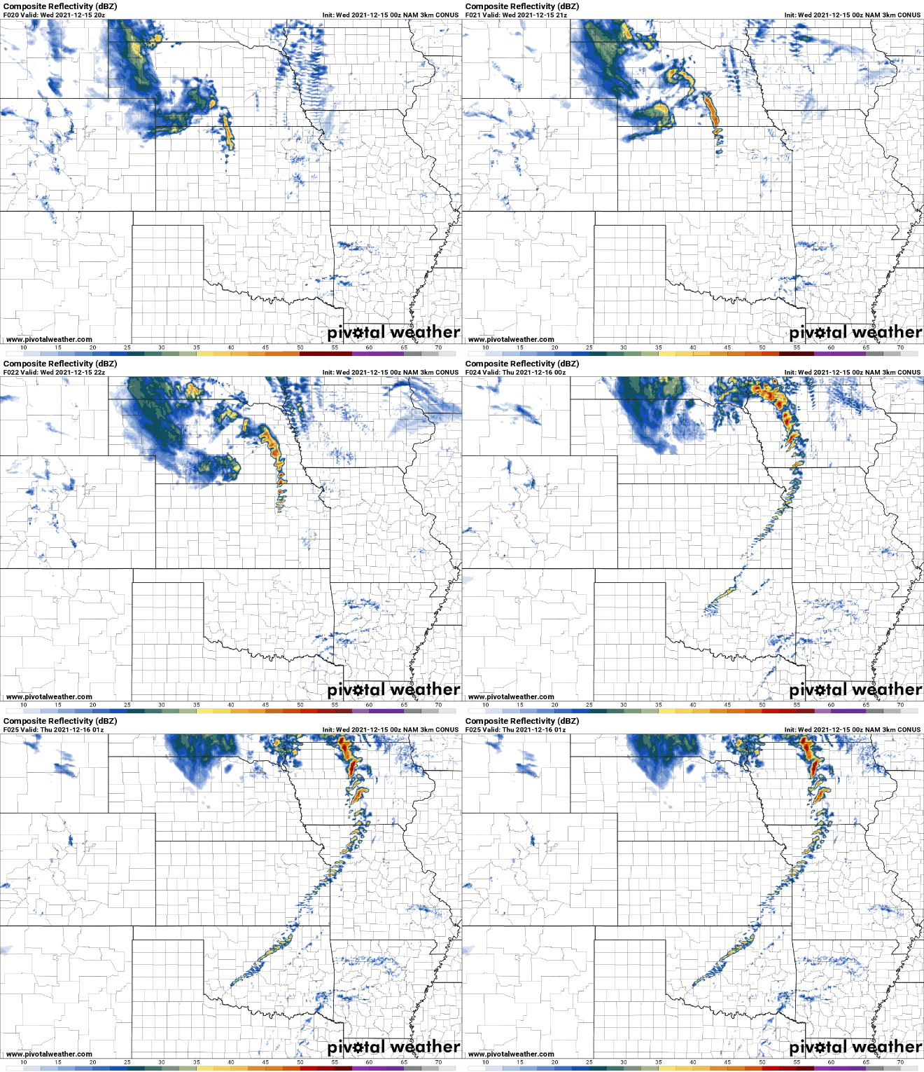
00z 3km NAM continues the westward trend with storms developing west of Omaha. On this run, it shows many of the storms remaining discrete. If this happens, it will definitely increase tornado potential locally. 00z HRRR keeps things more linear until you get north of Omaha. Just depends on how much veering there will be with low-level winds.
Simulated radar loop from the 3km NAM showing supercells in and around the Omaha area (with storm initiation well west of town):
-
Busguy2010
- City Council
- Posts: 7328
- Joined: Sat Apr 09, 2011 7:32 pm
- Location: North Central Omaha
Re: 2021 Weather thread-
^ Sorry, I meant such dominant southerly winds. The winds don't turn northerly until they start the calming down process, about 8, 9, 10pm. I can see that if storms stay more isolated and less linear, it would mean a greater likelihood of rotation.
-
stormchaser
- Planning Board
- Posts: 2380
- Joined: Fri Jun 01, 2018 8:14 am
Re: 2021 Weather thread-
I kind of assumed - just clarifying thoughBusguy2010 wrote: Tue Dec 14, 2021 8:25 pm ^ Sorry, I meant such dominant southerly winds. The winds don't turn northerly until they start the calming down process, about 8, 9, 10pm.
Even more concerning is a fair amount of these storms will occur after dark (especially in IA). Fast-moving, nighttime tornadoes are never a good recipe...especially considering its DecemberBusguy2010 wrote: Tue Dec 14, 2021 8:25 pm I can see that if storms stay more isolated and less linear, it would mean a greater likelihood of rotation.
-
Cermak
- Planning Board
- Posts: 2331
- Joined: Thu Nov 29, 2018 1:02 pm
Re: 2021 Weather thread-
I’m curious to see how this all plays out. One of the few things I like about winter is we don’t have to deal with severe thunderstorm/Tornado weather, now maybe that isn’t the case anymore. 75mph winds will probably do some sort of damage, at least small to medium sized tree limbs down and power outages , large already weakened trees could topple over on cars and structures . A really strange weather event for December or any winter month.
-
stormchaser
- Planning Board
- Posts: 2380
- Joined: Fri Jun 01, 2018 8:14 am
Re: 2021 Weather thread-
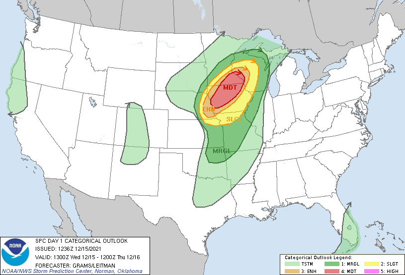
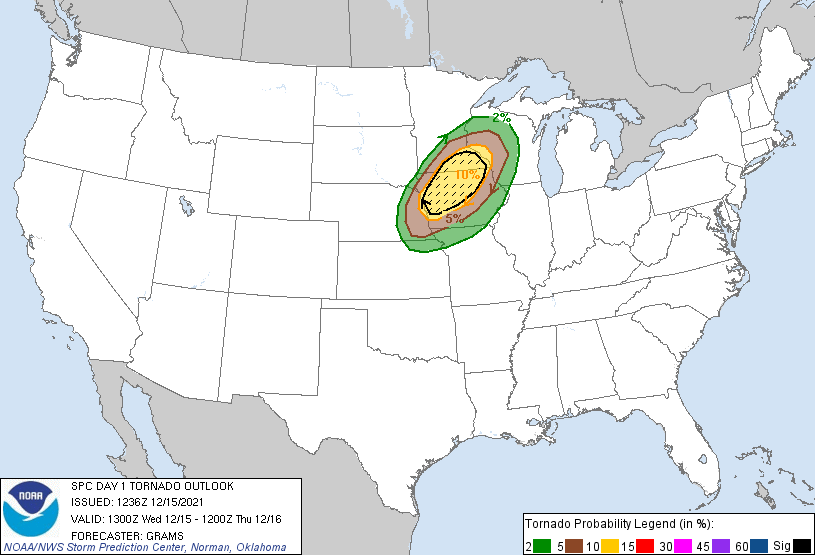
SPC upgraded things even further - Moderate risk now very close to Omaha with a 10% tornado threat. Unfortunately, fast-moving, strong tornadoes and damaging wind (80-100mph+ winds) look fairly likely at this point...some of which will occur after dark (though the after-dark stuff would probably be east of Omaha).
-
Brad
- Photographer
- Posts: 1036562
- Joined: Sat Feb 28, 2004 6:03 pm
- Location: Omaha, NE
Re: 2021 Weather thread-
NWS Omaha put out this image showing us in the greatest tornado risk:

Omaha Skyline Photos, Omaha Aerial Photos, and More.
Website: www.bradwilliamsphotography.com
Facebook: www.facebook.com/bradwilliamsphotography
Twitter: www.twitter.com/bradwphoto
Instagram: www.instagram.com/bradwilliamsphotography
YouTube: www.youtube.com/@bradwilliamsphoto
-
stormchaser
- Planning Board
- Posts: 2380
- Joined: Fri Jun 01, 2018 8:14 am
Re: 2021 Weather thread-
Going to be interesting that's for sure. Hopefully, people are paying attention and take the warnings seriously...Brad wrote: Wed Dec 15, 2021 8:14 am NWS Omaha put out this image showing us in the greatest tornado risk: