That is pretty crazy. I pretty much had a half day today, but when coming home and a quick stop at the grocery store, I noticed my vehicle, as well as everyone else's was covered in a dust/water mixture. Just such a weird day. I'm glad it turned out not that bad. Now, in the following days, it still looks to be about 10 degrees above normal, aside from Saturday when the high is 29, a few degrees below normal. Overall, I'd have to say the warm weather crowd should be very, very pleased with this Fall so far. Outside of only a few sprinkled in days that have been below normal, this fall has been wellllllll above normal... I'm over it. I soooo hope for a good snow storm by Christmas. One like last Friday would suffice. Just something.stormchaser wrote: Thu Dec 16, 2021 1:47 am Unreal the dust that was kicked up by this storm. You can see it from visible satellite earlier being pulled from CO into KS and up into southern NE. Just a monster storm system…
2021 Weather thread-
-
Busguy2010

- City Council
- Posts: 7393
- Joined: Sun Apr 10, 2011 12:32 am
- Location: North Central Omaha
Re: 2021 Weather thread-
-
Brad

- Photographer
- Posts: 1036702
- Joined: Sun Feb 29, 2004 12:03 am
- Location: Omaha, NE
Re: 2021 Weather thread-
We sure did dodge a bullet. Storm Damage in every direction of Omaha.
Today was our first Torando Watch and Tornado Warning of 2021. We also set a record high for the entire month of December.
Here is a quick time-lapse I shot from my driveway. Nothing severe.
Today was our first Torando Watch and Tornado Warning of 2021. We also set a record high for the entire month of December.
Here is a quick time-lapse I shot from my driveway. Nothing severe.

Omaha Skyline Photos, Omaha Aerial Photos, and More.
Website: www.bradwilliamsphotography.com
Facebook: www.facebook.com/bradwilliamsphotography
Twitter: www.twitter.com/bradwphoto
Instagram: www.instagram.com/bradwilliamsphotography
YouTube: www.youtube.com/@bradwilliamsphoto
-
BRoss

- IT Director
- Posts: 10003423
- Joined: Sat Aug 05, 2006 12:39 am
- Location: West Central Omaha
Re: 2021 Weather thread-
The OmaDome strikes again! 
-
Omaha Cowboy

- The Don
- Posts: 1013736
- Joined: Wed Jan 07, 2004 11:31 am
- Location: West Omaha
Re: 2021 Weather thread-
Indeed! I just wish it would do a better job keeping frozen precipitation out
 …
Ciao..LiO…Peace
Go Cowboys!
-
skinzfan23
- City Council
- Posts: 11671
- Joined: Mon Feb 09, 2004 5:26 pm
- Location: Omaha/Bellevue
Re: 2021 Weather thread-
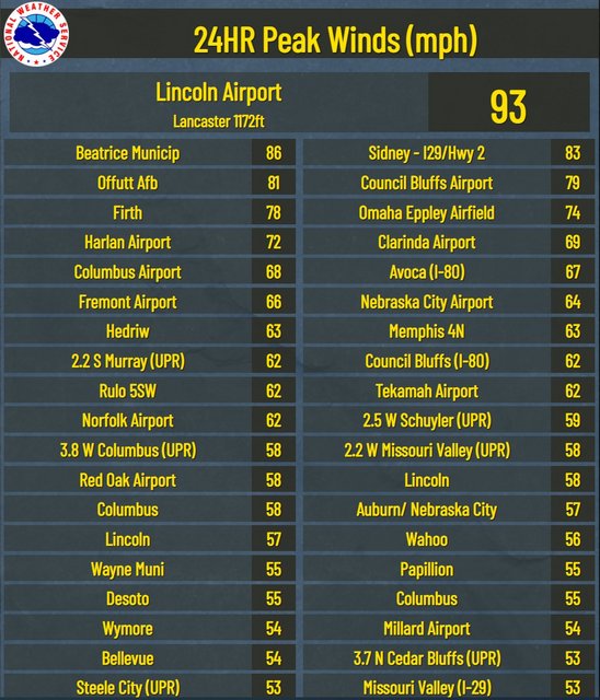
We didn't have anything bad in Bellevue, but Offutt recorded an 81 mph wind gust. I actually thought the wind in nightime was worse. In the first wave, we had strong winds, pea-sized hail and heavy rain for 5-10 min.
Between 8-10 pm the winds were very strong (not sure on wind gusts) but it broke the gate on our vinyl privacy fence. It basically turned it inside out and cracked/tore the top and bottom rails from the post. Hopefully I can get the matching rails and it will be a quick, easy fix.
Between 8-10 pm the winds were very strong (not sure on wind gusts) but it broke the gate on our vinyl privacy fence. It basically turned it inside out and cracked/tore the top and bottom rails from the post. Hopefully I can get the matching rails and it will be a quick, easy fix.
-
Busguy2010
- City Council
- Posts: 7393
- Joined: Sun Apr 10, 2011 12:32 am
- Location: North Central Omaha
Re: 2021 Weather thread-
I agree. With what wind I experienced during the 4:00, later that night seemed just as bad, if not worse. Could have been. The NWS reported 60mph winds during the 8:00 hour, and only 36mph during the 4:00 hour. I guess the hourly reports arent a reliable source because I'm now finding they only report a snapshot of the conditions at 0:52 of an hour, so at 4:52, the main storm would have been over. I did find out that the peak wind gust at Eppley was 74 around 4:20. And 70 again later at 7 something.skinzfan23 wrote: Thu Dec 16, 2021 4:21 pm We didn't have anything bad in Bellevue, but Offutt recorded an 81 mph wind gust. I actually thought the wind in nightime was worse. In the first wave, we had strong winds, pea-sized hail and heavy rain for 5-10 min.
Between 8-10 pm the winds were very strong (not sure on wind gusts) but it broke the gate on our vinyl privacy fence. It basically turned it inside out and cracked/tore the top and bottom rails from the post. Hopefully I can get the matching rails and it will be a quick, easy fix.
-
skinzfan23
- City Council
- Posts: 11671
- Joined: Mon Feb 09, 2004 5:26 pm
- Location: Omaha/Bellevue
Re: 2021 Weather thread-
I just think the winds later were more intense because they lasted for so long (a few hours) rather than the 5-10 burst.
-
stormchaser
- Planning Board
- Posts: 2380
- Joined: Fri Jun 01, 2018 1:14 pm
Re: 2021 Weather thread-
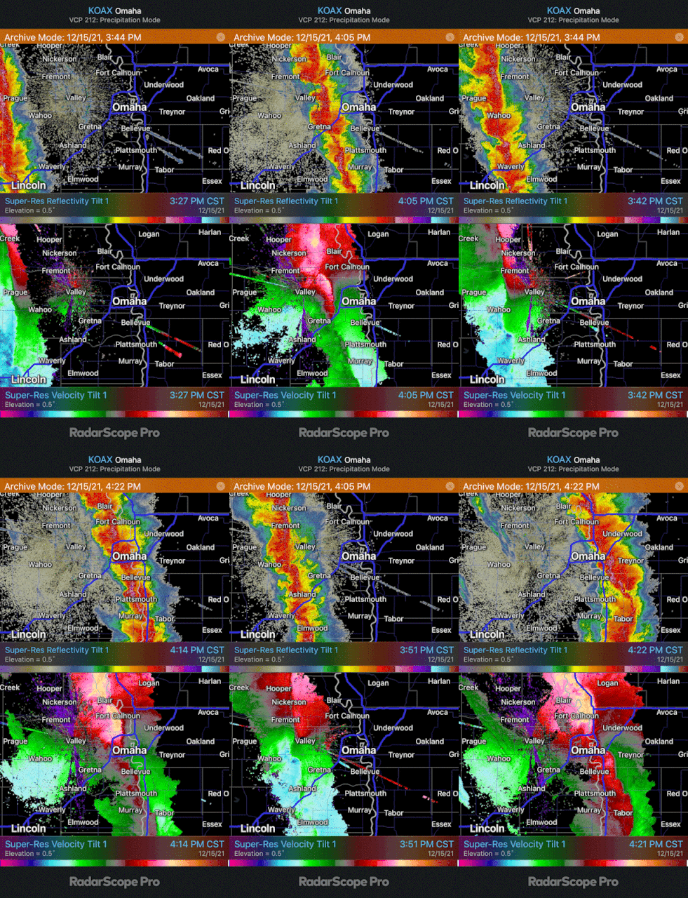
Radar loop of how the storms in and around Omaha evolved. You can see the tornado/rotation that I saw west of Ashland toward the beginning of the loop as it moves up toward Valley before dissipating. You can also see how the damaging wind evolved and hit northwest Omaha and passed mostly north of town and southeast of Omaha (including Offut which Skinzfan23 referred to) - and then a new tornadic circulation that developed east of Plattsmouth in adjacent parts of IA at the end of the loop.
Omaha dodged a bullet - plain and simple. But this definitely wasn't "overhyped".
Omaha dodged a bullet - plain and simple. But this definitely wasn't "overhyped".
-
stormchaser
- Planning Board
- Posts: 2380
- Joined: Fri Jun 01, 2018 1:14 pm
Re: 2021 Weather thread-
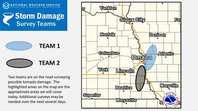
Posts from NWS Omaha:
-
skinzfan23
- City Council
- Posts: 11671
- Joined: Mon Feb 09, 2004 5:26 pm
- Location: Omaha/Bellevue
Re: 2021 Weather thread-
Thanks for posting those maps, interesting to see the Oma-dome in full effect.
-
stormchaser
- Planning Board
- Posts: 2380
- Joined: Fri Jun 01, 2018 1:14 pm
Re: 2021 Weather thread-
For anyone who still thinks this was "overhyped". Again, Omaha just dodged the bullet.
Damage survey from the NWS so far (more on-going today west of Omaha) - at least 5 EF2 tornadoes (which are considered to be "strong" tornadoes) in our area and 2 EF1 tornadoes:
https://www.weather.gov/oax/dec1521
...NWS DAMAGE SURVEY FOR 12/15/21 TORNADO EVENT...
.7 SW UNDERWOOD, IA...
RATING: EF-2
ESTIMATED PEAK WIND: 120 MPH
PATH LENGTH /STATUTE/: 2.3 MILES
PATH WIDTH /MAXIMUM/: 50 YARDS
FATALITIES: 0
INJURIES: 0
START DATE: DEC 15 2021
START TIME: 424 PM CST
START LOCATION: 7 MILES SW UNDERWOOD / POTTAWATTAMIE / IA
START LAT/LON: 41.3140 / -95.7655
END DATE: DEC 15 2021
END TIME: 427 PM CST
END LOCATION: 5 MILES SW UNDERWOOD / POTTAWATTAMIE / IA
END LAT/LON: 41.3471 / -95.7579
SURVEY SUMMARY: A NARROW BUT STRONG TORNADO TRACKED ALONG ROAD
L34 THROUGH SHERWOOD COUNTRY ESTATES BEFORE ENDING NEAR JUNIPER
ROAD. THE MAXIMUM DAMAGE WAS SUSTAINED TO A HOME IN SHERWOOD
COUNTRY ESTATES WHERE THE NARROW TORNADO REMOVED THE MAJORITY OF A
HOMES ROOF AND DAMAGED OTHER NEARBY HOMES AS WELL.
.NEOLA, IA...
RATING: EF-2
ESTIMATED PEAK WIND: 125 MPH
PATH LENGTH /STATUTE/: 6.7 MILES
PATH WIDTH /MAXIMUM/: 75 YARDS
FATALITIES: 0
INJURIES: 0
START DATE: DEC 15 2021
START TIME: 431 PM CST
START LOCATION: 2 MILES E UNDERWOOD / POTTAWATTAMIE / IA
START LAT/LON: 41.3867 / -95.6366
END DATE: DEC 15 2021
END TIME: 436 PM CST
END LOCATION: 2 MILES NNE NEOLA / POTTAWATTAMIE / IA
END LAT/LON: 41.4799 / -95.6038
SURVEY SUMMARY: A NARROW EF-2 TORNADO BEGAN PRODUCING DAMAGE NEAR
MAHOGANY ROAD AND 290TH ST AND TRACKED NORTH NORTHEAST INTO THE
SOUTHEAST EDGE OF NEOLA AND THEN CAUSED INTERMITTENT DAMAGE NEAR
RAILROAD HIGHWAY NORTH OF NEOLA. THE MOST SIGNIFICANT DAMAGE WAS
TO A HOME ALONG 290TH STREET WHERE THE ROOF WAS REMOVED AND WALLS
BLOWN OUT. A NEARBY GARAGE WAS MOVED OFF OF ITS FOUNDATION AND
APPROXIMATELY 10 MATURE TREES WERE ALL UPROOTED BEHIND THE HOME
WITH SUBSTANTIAL DAMAGE TO HARDWOOD TREES IN THE FRONT YARD. THE
NARROW NATURE OF THIS TORNADO WAS EVIDENT IN THE DAMAGE PATH AS
NEARBY BARNS ON THE EAST SIDE OF THE TRACK HAD LOW-END DAMAGE,
POSSIBLY OWING TO THE SIGNIFICANT FORWARD SPEED OF THE TORNADO.
THE TORNADO WAS SEEN BRIEFLY BY THE RESIDENT BEFORE SEEKING
SHELTER. A BUSINESS ON THE SOUTHEAST SIDE OF NEOLA ALSO HAD
SUBSTANTIAL DAMAGE TO LARGE METAL BUILDINGS, AT LEAST TWO OF WHICH
WERE DESTROYED.
.2 NE BEAVER LAKE, NE...
RATING: EF-2
ESTIMATED PEAK WIND: 125 MPH
PATH LENGTH /STATUTE/: 0.8 MILES
PATH WIDTH /MAXIMUM/: 200 YARDS
FATALITIES: 0
INJURIES: 0
START DATE: DEC 15 2021
START TIME: 410 PM CST
START LOCATION: 4 MILES ENE MURRAY / CASS / NE
START LAT/LON: 40.9429 / -95.8630
END DATE: DEC 15 2021
END TIME: 411 PM CST
END LOCATION: 4 MILES NE MURRAY / CASS / NE
END LAT/LON: 40.9532 / -95.8579
SURVEY SUMMARY: TORNADO DEVELOPED IN OPEN FIELD AND TRAVELED
NORTH-NORTHEAST. SUBSTANTIAL DAMAGE WAS DONE TO A HORSE FARM.
EXTENSION OF HOUSE DESTROYED. HORSE TRAILER ROLLED. SEVERAL LARGE
TREES SNAPPED AN UPROOTED. UNABLE TO SURVEY NORTHERN END OF TRACK
DUE TO TERRAIN AND NO ROAD.
.BEAVER LAKE, NE...
RATING: EF-2
ESTIMATED PEAK WIND: 125 MPH
PATH LENGTH /STATUTE/: 0.5 MILES
PATH WIDTH /MAXIMUM/: 50 YARDS
FATALITIES: 0
INJURIES: 0
START DATE: DEC 15 2021
START TIME: 409 PM CST
START LOCATION: 2 MILES NE MURRAY / CASS / NE
START LAT/LON: 40.9197 / -95.8794
END DATE: DEC 15 2021
END TIME: 410 PM CST
END LOCATION: 2 MILES ENE MURRAY / CASS / NE
END LAT/LON: 40.9269 / -95.8767
SURVEY SUMMARY: THREE WITNESSES OBSERVED TORNADO FORM SOUTH SIDE
OF LAKE. ROOF TAKEN OFF RESIDENCE. SEVERAL HARDWOOD TREES SNAPPED
AND PINE TREES UPROOTED OR SNAPPED.
.3 SW BEAVER LAKE, NE...
RATING: EF-1
ESTIMATED PEAK WIND: 110 MPH
PATH LENGTH /STATUTE/: 1 MILE
PATH WIDTH /MAXIMUM/: TBD
FATALITIES: 0
INJURIES: 0
START DATE: DEC 15 2021
START TIME: 406 PM CST
START LOCATION: 3 MILES SSE MURRAY / CASS / NE
START LAT/LON: 40.8855 / -95.9154
END DATE: DEC 15 2021
END TIME: 407 PM CST
END LOCATION: 2 MILES SE MURRAY / CASS / NE
END LAT/LON: 40.8985 / -95.9051
SURVEY SUMMARY: A BRIEF EF-1 TORNADO CAUSED DAMAGE TO POWER POLES
AND TOTAL DESTRUCTION OF A FARM OUTBUILDING NEAR HIGHWAY 75 AND
BAXTER LOOP.
.3 NE NEHAWKA, NE...
RATING: EF-2
ESTIMATED PEAK WIND: 125 MPH
PATH LENGTH /STATUTE/: 0.8 MILES
PATH WIDTH /MAXIMUM/: 100 YARDS
FATALITIES: 0
INJURIES: 0
START DATE: DEC 15 2021
START TIME: 405 PM CST
START LOCATION: 3 MILES NE NEHAWKA / CASS / NE
START LAT/LON: 40.8569 / -95.9464
END DATE: DEC 15 2021
END TIME: 406 PM CST
END LOCATION: 4 MILES NE NEHAWKA / CASS / NE
END LAT/LON: 40.8656 / -95.9360
SURVEY SUMMARY: ROOF REMOVED FROM HOUSE. ROOF OVER GARAGE
UPLIFTED AND DISPLACED. HOUSE MOVED SLIGHTLY ON FOUNDATION.
SEVERAL LARGE PINES & OAK TREES SNAPPED.
.6 NW NEBRASKA CITY, NE...
RATING: EF-1
ESTIMATED PEAK WIND: 100 MPH
PATH LENGTH /STATUTE/: 0.1 MILES
PATH WIDTH /MAXIMUM/: TBD
FATALITIES: 0
INJURIES: 0
START DATE: DEC 15 2021
START TIME: 405 PM CST
START LOCATION: 6 MILES NW NEBRASKA CITY / OTOE / NE
START LAT/LON: 40.7544 / -95.9283
END DATE: DEC 15 2021
END TIME: 405 PM CST
END LOCATION: 6 MILES NW NEBRASKA CITY / OTOE / NE
END LAT/LON: 40.7561 / -95.9273
SURVEY SUMMARY: A BRIEF EF-1 TORNADO SNAPPED POWER POLES.
SWIRLING WAS NOTED IN CORN FIELDS NORTH AND SOUTH OF COUNTY ROAD
C.
&&
EF SCALE: THE ENHANCED FUJITA SCALE CLASSIFIES TORNADOES INTO THE
FOLLOWING CATEGORIES:
EF0...WEAK......65 TO 85 MPH
EF1...WEAK......86 TO 110 MPH
EF2...STRONG....111 TO 135 MPH
EF3...STRONG....136 TO 165 MPH
EF4...VIOLENT...166 TO 200 MPH
EF5...VIOLENT...>200 MPH
NOTE:
THE INFORMATION IN THIS STATEMENT IS PRELIMINARY AND SUBJECT TO
CHANGE PENDING FINAL REVIEW OF THE EVENTS AND PUBLICATION IN NWS
STORM DATA.
Damage survey from the NWS so far (more on-going today west of Omaha) - at least 5 EF2 tornadoes (which are considered to be "strong" tornadoes) in our area and 2 EF1 tornadoes:
https://www.weather.gov/oax/dec1521
...NWS DAMAGE SURVEY FOR 12/15/21 TORNADO EVENT...
.7 SW UNDERWOOD, IA...
RATING: EF-2
ESTIMATED PEAK WIND: 120 MPH
PATH LENGTH /STATUTE/: 2.3 MILES
PATH WIDTH /MAXIMUM/: 50 YARDS
FATALITIES: 0
INJURIES: 0
START DATE: DEC 15 2021
START TIME: 424 PM CST
START LOCATION: 7 MILES SW UNDERWOOD / POTTAWATTAMIE / IA
START LAT/LON: 41.3140 / -95.7655
END DATE: DEC 15 2021
END TIME: 427 PM CST
END LOCATION: 5 MILES SW UNDERWOOD / POTTAWATTAMIE / IA
END LAT/LON: 41.3471 / -95.7579
SURVEY SUMMARY: A NARROW BUT STRONG TORNADO TRACKED ALONG ROAD
L34 THROUGH SHERWOOD COUNTRY ESTATES BEFORE ENDING NEAR JUNIPER
ROAD. THE MAXIMUM DAMAGE WAS SUSTAINED TO A HOME IN SHERWOOD
COUNTRY ESTATES WHERE THE NARROW TORNADO REMOVED THE MAJORITY OF A
HOMES ROOF AND DAMAGED OTHER NEARBY HOMES AS WELL.
.NEOLA, IA...
RATING: EF-2
ESTIMATED PEAK WIND: 125 MPH
PATH LENGTH /STATUTE/: 6.7 MILES
PATH WIDTH /MAXIMUM/: 75 YARDS
FATALITIES: 0
INJURIES: 0
START DATE: DEC 15 2021
START TIME: 431 PM CST
START LOCATION: 2 MILES E UNDERWOOD / POTTAWATTAMIE / IA
START LAT/LON: 41.3867 / -95.6366
END DATE: DEC 15 2021
END TIME: 436 PM CST
END LOCATION: 2 MILES NNE NEOLA / POTTAWATTAMIE / IA
END LAT/LON: 41.4799 / -95.6038
SURVEY SUMMARY: A NARROW EF-2 TORNADO BEGAN PRODUCING DAMAGE NEAR
MAHOGANY ROAD AND 290TH ST AND TRACKED NORTH NORTHEAST INTO THE
SOUTHEAST EDGE OF NEOLA AND THEN CAUSED INTERMITTENT DAMAGE NEAR
RAILROAD HIGHWAY NORTH OF NEOLA. THE MOST SIGNIFICANT DAMAGE WAS
TO A HOME ALONG 290TH STREET WHERE THE ROOF WAS REMOVED AND WALLS
BLOWN OUT. A NEARBY GARAGE WAS MOVED OFF OF ITS FOUNDATION AND
APPROXIMATELY 10 MATURE TREES WERE ALL UPROOTED BEHIND THE HOME
WITH SUBSTANTIAL DAMAGE TO HARDWOOD TREES IN THE FRONT YARD. THE
NARROW NATURE OF THIS TORNADO WAS EVIDENT IN THE DAMAGE PATH AS
NEARBY BARNS ON THE EAST SIDE OF THE TRACK HAD LOW-END DAMAGE,
POSSIBLY OWING TO THE SIGNIFICANT FORWARD SPEED OF THE TORNADO.
THE TORNADO WAS SEEN BRIEFLY BY THE RESIDENT BEFORE SEEKING
SHELTER. A BUSINESS ON THE SOUTHEAST SIDE OF NEOLA ALSO HAD
SUBSTANTIAL DAMAGE TO LARGE METAL BUILDINGS, AT LEAST TWO OF WHICH
WERE DESTROYED.
.2 NE BEAVER LAKE, NE...
RATING: EF-2
ESTIMATED PEAK WIND: 125 MPH
PATH LENGTH /STATUTE/: 0.8 MILES
PATH WIDTH /MAXIMUM/: 200 YARDS
FATALITIES: 0
INJURIES: 0
START DATE: DEC 15 2021
START TIME: 410 PM CST
START LOCATION: 4 MILES ENE MURRAY / CASS / NE
START LAT/LON: 40.9429 / -95.8630
END DATE: DEC 15 2021
END TIME: 411 PM CST
END LOCATION: 4 MILES NE MURRAY / CASS / NE
END LAT/LON: 40.9532 / -95.8579
SURVEY SUMMARY: TORNADO DEVELOPED IN OPEN FIELD AND TRAVELED
NORTH-NORTHEAST. SUBSTANTIAL DAMAGE WAS DONE TO A HORSE FARM.
EXTENSION OF HOUSE DESTROYED. HORSE TRAILER ROLLED. SEVERAL LARGE
TREES SNAPPED AN UPROOTED. UNABLE TO SURVEY NORTHERN END OF TRACK
DUE TO TERRAIN AND NO ROAD.
.BEAVER LAKE, NE...
RATING: EF-2
ESTIMATED PEAK WIND: 125 MPH
PATH LENGTH /STATUTE/: 0.5 MILES
PATH WIDTH /MAXIMUM/: 50 YARDS
FATALITIES: 0
INJURIES: 0
START DATE: DEC 15 2021
START TIME: 409 PM CST
START LOCATION: 2 MILES NE MURRAY / CASS / NE
START LAT/LON: 40.9197 / -95.8794
END DATE: DEC 15 2021
END TIME: 410 PM CST
END LOCATION: 2 MILES ENE MURRAY / CASS / NE
END LAT/LON: 40.9269 / -95.8767
SURVEY SUMMARY: THREE WITNESSES OBSERVED TORNADO FORM SOUTH SIDE
OF LAKE. ROOF TAKEN OFF RESIDENCE. SEVERAL HARDWOOD TREES SNAPPED
AND PINE TREES UPROOTED OR SNAPPED.
.3 SW BEAVER LAKE, NE...
RATING: EF-1
ESTIMATED PEAK WIND: 110 MPH
PATH LENGTH /STATUTE/: 1 MILE
PATH WIDTH /MAXIMUM/: TBD
FATALITIES: 0
INJURIES: 0
START DATE: DEC 15 2021
START TIME: 406 PM CST
START LOCATION: 3 MILES SSE MURRAY / CASS / NE
START LAT/LON: 40.8855 / -95.9154
END DATE: DEC 15 2021
END TIME: 407 PM CST
END LOCATION: 2 MILES SE MURRAY / CASS / NE
END LAT/LON: 40.8985 / -95.9051
SURVEY SUMMARY: A BRIEF EF-1 TORNADO CAUSED DAMAGE TO POWER POLES
AND TOTAL DESTRUCTION OF A FARM OUTBUILDING NEAR HIGHWAY 75 AND
BAXTER LOOP.
.3 NE NEHAWKA, NE...
RATING: EF-2
ESTIMATED PEAK WIND: 125 MPH
PATH LENGTH /STATUTE/: 0.8 MILES
PATH WIDTH /MAXIMUM/: 100 YARDS
FATALITIES: 0
INJURIES: 0
START DATE: DEC 15 2021
START TIME: 405 PM CST
START LOCATION: 3 MILES NE NEHAWKA / CASS / NE
START LAT/LON: 40.8569 / -95.9464
END DATE: DEC 15 2021
END TIME: 406 PM CST
END LOCATION: 4 MILES NE NEHAWKA / CASS / NE
END LAT/LON: 40.8656 / -95.9360
SURVEY SUMMARY: ROOF REMOVED FROM HOUSE. ROOF OVER GARAGE
UPLIFTED AND DISPLACED. HOUSE MOVED SLIGHTLY ON FOUNDATION.
SEVERAL LARGE PINES & OAK TREES SNAPPED.
.6 NW NEBRASKA CITY, NE...
RATING: EF-1
ESTIMATED PEAK WIND: 100 MPH
PATH LENGTH /STATUTE/: 0.1 MILES
PATH WIDTH /MAXIMUM/: TBD
FATALITIES: 0
INJURIES: 0
START DATE: DEC 15 2021
START TIME: 405 PM CST
START LOCATION: 6 MILES NW NEBRASKA CITY / OTOE / NE
START LAT/LON: 40.7544 / -95.9283
END DATE: DEC 15 2021
END TIME: 405 PM CST
END LOCATION: 6 MILES NW NEBRASKA CITY / OTOE / NE
END LAT/LON: 40.7561 / -95.9273
SURVEY SUMMARY: A BRIEF EF-1 TORNADO SNAPPED POWER POLES.
SWIRLING WAS NOTED IN CORN FIELDS NORTH AND SOUTH OF COUNTY ROAD
C.
&&
EF SCALE: THE ENHANCED FUJITA SCALE CLASSIFIES TORNADOES INTO THE
FOLLOWING CATEGORIES:
EF0...WEAK......65 TO 85 MPH
EF1...WEAK......86 TO 110 MPH
EF2...STRONG....111 TO 135 MPH
EF3...STRONG....136 TO 165 MPH
EF4...VIOLENT...166 TO 200 MPH
EF5...VIOLENT...>200 MPH
NOTE:
THE INFORMATION IN THIS STATEMENT IS PRELIMINARY AND SUBJECT TO
CHANGE PENDING FINAL REVIEW OF THE EVENTS AND PUBLICATION IN NWS
STORM DATA.
-
Brad
- Photographer
- Posts: 1036702
- Joined: Sun Feb 29, 2004 12:03 am
- Location: Omaha, NE
Re: 2021 Weather thread-
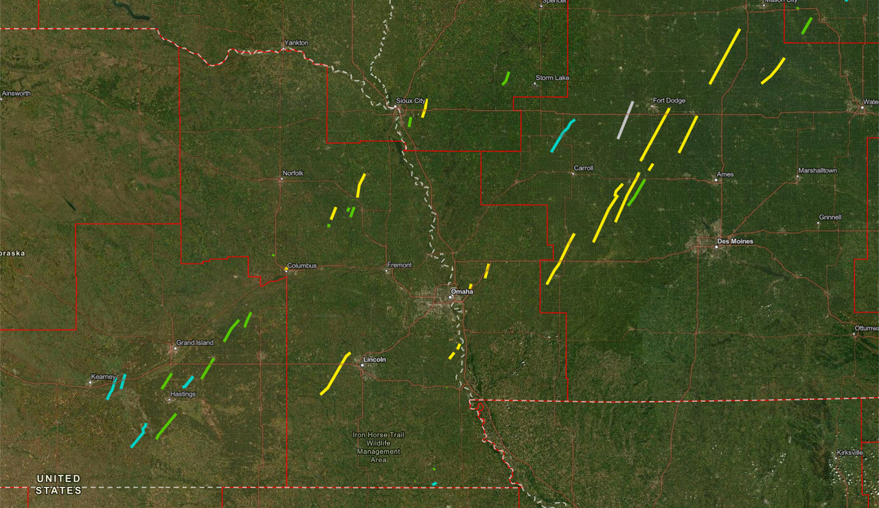
Here is that same information summarized in a map:

Omaha Skyline Photos, Omaha Aerial Photos, and More.
Website: www.bradwilliamsphotography.com
Facebook: www.facebook.com/bradwilliamsphotography
Twitter: www.twitter.com/bradwphoto
Instagram: www.instagram.com/bradwilliamsphotography
YouTube: www.youtube.com/@bradwilliamsphoto
-
stormchaser
- Planning Board
- Posts: 2380
- Joined: Fri Jun 01, 2018 1:14 pm
Re: 2021 Weather thread-
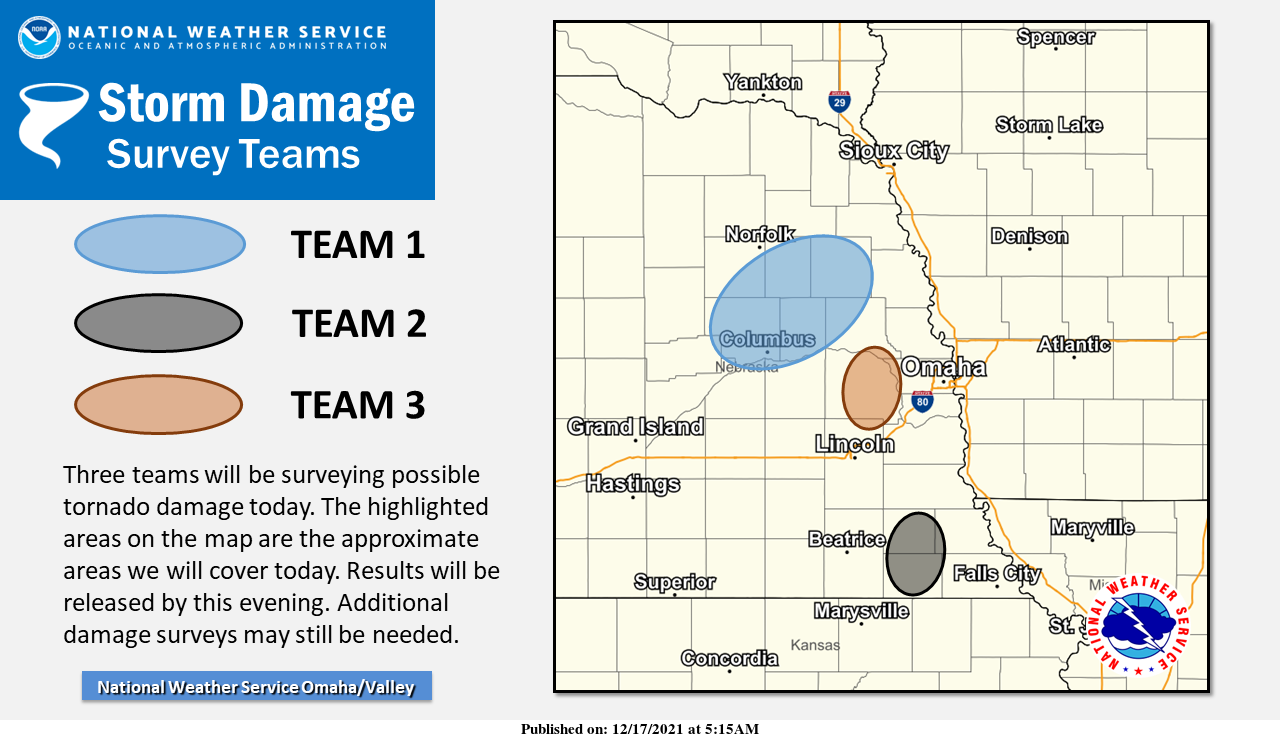
Additional damage surveys that are being worked on today. Pretty good chance we will have several additional confirmed tornadoes from these...
-
Brad
- Photographer
- Posts: 1036702
- Joined: Sun Feb 29, 2004 12:03 am
- Location: Omaha, NE
Re: 2021 Weather thread-
Still Evaluating, but at least 17 tornadoes in the NWS Omaha Coverage Area.
Omaha Skyline Photos, Omaha Aerial Photos, and More.
Website: www.bradwilliamsphotography.com
Facebook: www.facebook.com/bradwilliamsphotography
Twitter: www.twitter.com/bradwphoto
Instagram: www.instagram.com/bradwilliamsphotography
YouTube: www.youtube.com/@bradwilliamsphoto
-
Busguy2010
- City Council
- Posts: 7393
- Joined: Sun Apr 10, 2011 12:32 am
- Location: North Central Omaha
Re: 2021 Weather thread-
I dunno. I think Omaha definitely dodged a bullet, but naming each touchdown as its own tornado seems like splitting hairs. Such as calling the beaver lake tornado four different tornadoes when the touchdowns were obviously generated from the same parent rotation. I get the reasoning behind it, but it is confusing and misleading.
-
GetUrban
- Planning Board
- Posts: 2650
- Joined: Sun Nov 23, 2008 9:07 pm
- Location: Omaha
Re: 2021 Weather thread-
I’m not a meteorologist, but I don’t think it’s that unusual for several tornados to spin-up on a long, fast-moving front. But this was especially strong and fast-moving. I wouldn’t be too surprised if it was 3-4 separate funnels. In the 1975 Omaha tornado, there were also several less intense tornados along the front spaced further apart although that was a more of a typical springtime setup.Busguy2010 wrote: Sat Dec 18, 2021 4:16 am I dunno. I think Omaha definitely dodged a bullet, but naming each touchdown as its own tornado seems like splitting hairs. Such as calling the beaver lake tornado four different tornadoes when the touchdowns were obviously generated from the same parent rotation. I get the reasoning behind it, but it is confusing and misleading.
He said "They are some big, ugly red brick buildings"
...and then they were gone.
...and then they were gone.
-
Busguy2010
- City Council
- Posts: 7393
- Joined: Sun Apr 10, 2011 12:32 am
- Location: North Central Omaha
Re: 2021 Weather thread-
No, I totally get that. If its not on the ground, its not a tornado. So that is why they count each touchdown as its own tornado. I just wonder if it really should be reported that way. Just using the Beaver lake tornado(es) as an example, they are so closely spaced that it is obvious that they were spawnings of the same tornado. So if you are on the ground, you are watching the same spot in the sky and the previous tornado to see if it will lift or touchdown again. So with whatever number they eventually come up with, there are sure to be some that you could conglomerate as one tornado track with liftings and touchdowns. I personally would count that type of situation as one tornado. Same thing happened with the West Omaha Tornado in April of 2016. They counted it as 3 different tornadoes when it was obviously the same circulation that failed to reach the ground during parts of it's track.GetUrban wrote: Sat Dec 18, 2021 4:55 am I’m not a meteorologist, but I don’t think it’s that unusual for several tornados to spin-up on a long, fast-moving front. But this was especially strong and fast-moving. I wouldn’t be too surprised if it was 3-4 separate funnels. In the 1975 Omaha tornado, there were also several less intense tornados along the front spaced further apart although that was a more of a typical springtime setup.
-
Busguy2010
- City Council
- Posts: 7393
- Joined: Sun Apr 10, 2011 12:32 am
- Location: North Central Omaha
Re: 2021 Weather thread-
Another part of that is, in a rural area, there may be no evidence of damage during certain parts simply because there's no structures or trees to be damaged. I think it would be perfectly acceptable to count that as one tornado in that type of situation.
-
stormchaser
- Planning Board
- Posts: 2380
- Joined: Fri Jun 01, 2018 1:14 pm
Re: 2021 Weather thread-
I could be mistaken but I believe they do that with preliminary reports only. Once they have the data they need, they combine the obvious ones into a single tornado (which they have with the most recent damage survey that Brad linked to). Still up to 16 in the latest report and counting…Busguy2010 wrote: Sat Dec 18, 2021 5:12 amNo, I totally get that. If its not on the ground, its not a tornado. So that is why they count each touchdown as its own tornado. I just wonder if it really should be reported that way. Just using the Beaver lake tornado(es) as an example, they are so closely spaced that it is obvious that they were spawnings of the same tornado. So if you are on the ground, you are watching the same spot in the sky and the previous tornado to see if it will lift or touchdown again. So with whatever number they eventually come up with, there are sure to be some that you could conglomerate as one tornado track with liftings and touchdowns. I personally would count that type of situation as one tornado. Same thing happened with the West Omaha Tornado in April of 2016. They counted it as 3 different tornadoes when it was obviously the same circulation that failed to reach the ground during parts of it's track.GetUrban wrote: Sat Dec 18, 2021 4:55 am I’m not a meteorologist, but I don’t think it’s that unusual for several tornados to spin-up on a long, fast-moving front. But this was especially strong and fast-moving. I wouldn’t be too surprised if it was 3-4 separate funnels. In the 1975 Omaha tornado, there were also several less intense tornados along the front spaced further apart although that was a more of a typical springtime setup.
The updated Beaver Lake tornado (where the damage path is combined into a single tornado):
BEAVER LAKE, NE TORNADO...
RATING: EF2
ESTIMATED PEAK WIND: 125 MPH
PATH LENGTH /STATUTE/: 2.5941 MILES
PATH WIDTH /MAXIMUM/: 200.0 YARDS
FATALITIES: 0
INJURIES: 0
START DATE: 12/15/2021
START TIME: 04:09 PM CST
START LOCATION: 2 E MURRAY / CASS COUNTY / NE
START LAT/LON: 40.9197 / -95.8794
END DATE: 12/16/2021
END TIME: 04:11 PM CST
END LOCATION: 4 SSE PLATTSMOUTH / CASS COUNTY / NE
END LAT/LON: 40.9532 / -95.8578
SURVEY SUMMARY:
THREE WITNESSES OBSERVED TORNADO FORM SOUTH SIDE OF LAKE. ROOF
TAKEN OFF RESIDENCE. SEVERAL HARDWOOD TREES SNAPPED AND PINE
TREES UPROOTED OR SNAPPED. TORNADO CONTINUED NORTHEAST WHERE IT
DID SUBSTANTIAL DAMAGE TO A HORSE FARM. EXTENSION OF HOUSE
DESTROYED. HORSE TRAILER ROLLED. SEVERAL LARGE TREES SNAPPED AN
UPROOTED. UNABLE TO SURVEY NORTHERN END OF TRACK DUE TO TERRAIN
AND NO ROAD.
-
stormchaser
- Planning Board
- Posts: 2380
- Joined: Fri Jun 01, 2018 1:14 pm
Re: 2021 Weather thread-
Up to 18 confirmed tornadoes in our area and counting including multiple EF2 tornadoes (considered to be "strong" tornadoes - the yellow paths on the map). Lincoln was just barely missed by one of these. Columbus wasn't so lucky (even though it was just a small part of town that was hit).
-
Brad
- Photographer
- Posts: 1036702
- Joined: Sun Feb 29, 2004 12:03 am
- Location: Omaha, NE
Re: 2021 Weather thread-
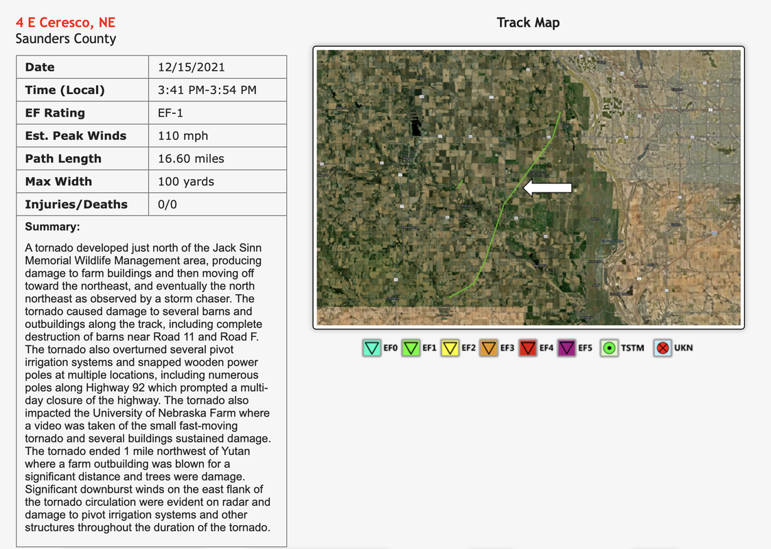
19 Confirmed now as they added a EF1 just to our west by Yutan.
NWS page for this storm: https://www.weather.gov/oax/dec1521
Update map:

NWS page for this storm: https://www.weather.gov/oax/dec1521
Update map:
Omaha Skyline Photos, Omaha Aerial Photos, and More.
Website: www.bradwilliamsphotography.com
Facebook: www.facebook.com/bradwilliamsphotography
Twitter: www.twitter.com/bradwphoto
Instagram: www.instagram.com/bradwilliamsphotography
YouTube: www.youtube.com/@bradwilliamsphoto
-
stormchaser
- Planning Board
- Posts: 2380
- Joined: Fri Jun 01, 2018 1:14 pm
Re: 2021 Weather thread-
Yep, that's the one I saw (I posted a couple of pictures of it a few posts up). Looks like they mentioned my report in the damage report for the tornado...Brad wrote: Mon Dec 20, 2021 4:15 pm 19 Confirmed now as they added a EF1 just to our west by Yutan.
NWS page for this storm: https://www.weather.gov/oax/dec1521
Update map:
-
Busguy2010
- City Council
- Posts: 7393
- Joined: Sun Apr 10, 2011 12:32 am
- Location: North Central Omaha
Re: 2021 Weather thread-
So is that the number of tornadoes in the OAX coverage area?
It does look like the forecast was correct that central to northern Iowa did get the worst of it.
To me, it looks like 8 decent tornadoes tops, with the rest being brief touchdowns. I don't want to count the brief touchdowns, especially when they probably are likely related to a close-by longer track tornado, but that is my opinion.
It does look like the forecast was correct that central to northern Iowa did get the worst of it.
To me, it looks like 8 decent tornadoes tops, with the rest being brief touchdowns. I don't want to count the brief touchdowns, especially when they probably are likely related to a close-by longer track tornado, but that is my opinion.
-
stormchaser
- Planning Board
- Posts: 2380
- Joined: Fri Jun 01, 2018 1:14 pm
Re: 2021 Weather thread-
Yes, 18 in the OAX coverage area (obviously many more elsewhere as well).Busguy2010 wrote: Mon Dec 20, 2021 9:59 pm So is that the number of tornadoes in the OAX coverage area?
It does look like the forecast was correct that central to northern Iowa did get the worst of it.
To me, it looks like 8 decent tornadoes tops, with the rest being brief touchdowns. I don't want to count the brief touchdowns, especially when they probably are likely related to a close-by longer track tornado, but that is my opinion.
While I get what you're saying the official totals will reflect any tornado touchdown that they can identify through a damage survey (brief or otherwise). Part of the reason it's necessary to count them all is for insurance purposes for property owners who sustained damage (as well as just documenting things as best as possible). Also, keep in mind - there are likely additional brief tornadoes that touched down that didn't get counted because they didn't damage anything (especially if rain-wrapped or occurred after dark). Either way, DEFINITELY a forecast that verified and deserved the hype that it got. Omaha got lucky - things could have been MUCH worse...
Also, it's worth noting in the tornado damage report for just west of Omaha they made mention of a microburst on the east side of the tornado. These are the winds I experienced that were likely approaching 100 mph as I drove north paralleling the storm.
-
stormchaser
- Planning Board
- Posts: 2380
- Joined: Fri Jun 01, 2018 1:14 pm
Re: 2021 Weather thread-
Things continue to look quiet as far as accumulating snow across the Omaha area based on long-range models for the next week or 2 (though things can always quickly change). The Dakotas and MN will likely get some significant snow accumulations though. Even temps in the mid to upper 50s later this week.
Long-range 12z GFS is even showing another potential severe weather setup for our area around January 2nd. It's a LONG way out and will undoubtedly change (typically not even worth mentioning yet because it has very little chance of actually verifying) but I mention it because it's interesting how so far this "winter" we've really had anything BUT winter in our area. Glad I didn't go out and buy a snowblower like I was planning...
Long-range 12z GFS is even showing another potential severe weather setup for our area around January 2nd. It's a LONG way out and will undoubtedly change (typically not even worth mentioning yet because it has very little chance of actually verifying) but I mention it because it's interesting how so far this "winter" we've really had anything BUT winter in our area. Glad I didn't go out and buy a snowblower like I was planning...
-
Busguy2010
- City Council
- Posts: 7393
- Joined: Sun Apr 10, 2011 12:32 am
- Location: North Central Omaha
Re: 2021 Weather thread-
Yeaaa... I'm kinda bummed on the first day of winter, it doesn't look like winter. And a high of 43 today is quite mild, even more like mid 50's on Christmas. Feels more like spring... But at least - I would hope - we are done with anything over 60 for a while, which even though it still looks about 10-20+ degrees above normal, I can accept.
One thing I thought was beautiful last night was that despite it being about 16 degrees at the time, it really didn't feel cold. There was absolutely no wind. And going outside at about 2:00am I could probably hear a pin drop two blocks away. And I actually did hear a train on the BNSF tracks in Ralston, even though I'm a good 6 or 7 miles north of there with quite a few substantial hills in between. There was absolutely not a soul out last night and it was totally serene.
One thing I thought was beautiful last night was that despite it being about 16 degrees at the time, it really didn't feel cold. There was absolutely no wind. And going outside at about 2:00am I could probably hear a pin drop two blocks away. And I actually did hear a train on the BNSF tracks in Ralston, even though I'm a good 6 or 7 miles north of there with quite a few substantial hills in between. There was absolutely not a soul out last night and it was totally serene.
-
Cermak
- Planning Board
- Posts: 2348
- Joined: Thu Nov 29, 2018 7:02 pm
Re: 2021 Weather thread-
Seems like we’ve had a bunch of mild December’s for a while now. Then it finally gets colder sometime in January. Two of the last three February’s have been cold and snowy.
-
stormchaser
- Planning Board
- Posts: 2380
- Joined: Fri Jun 01, 2018 1:14 pm
Re: 2021 Weather thread-
We had way more snow though in December last year - actually in general accumulating snow started in October the last few years.Cermak wrote: Tue Dec 21, 2021 10:22 pm Seems like we’ve had a bunch of mild December’s for a while now. Then it finally gets colder sometime in January. Two of the last three February’s have been cold and snowy.
I realize this is for Lincoln but snow totals in Omaha I’m sure were fairly similar - https://lincolnweather.unl.edu/data/mon ... asonal.asp
-
Cermak
- Planning Board
- Posts: 2348
- Joined: Thu Nov 29, 2018 7:02 pm
Re: 2021 Weather thread-
Your right last December was somewhat snowy. It will be interesting to see how the rest of this winter plays out. So far it’s been mild and dry with just a few cold days and about 1.5 inches of snow at my house. I wonder if this pattern will hold or will it get colder and snowier like last winter. I’d rather have cold and snow than tornadoes.
-
Busguy2010
- City Council
- Posts: 7393
- Joined: Sun Apr 10, 2011 12:32 am
- Location: North Central Omaha
Re: 2021 Weather thread-
Last December was actually on par as far as snowfall goes, until we got an additional 6" on the 29th. Then, it looks like 2018 was the other year with normal snowfall, then 2015. The rest were fairly dry. This December kinda looks like it'll be one of the driest in the books. Plus we already smashed the all-time record December high, as well as the latest highest temperature. Its been an odd one, and yes, I agree, I'd prefer to be dabbling in winter storms, not tornado warnings in December.Cermak wrote: Wed Dec 22, 2021 2:30 am Your right last December was somewhat snowy. It will be interesting to see how the rest of this winter plays out. So far it’s been mild and dry with just a few cold days and about 1.5 inches of snow at my house. I wonder if this pattern will hold or will it get colder and snowier like last winter. I’d rather have cold and snow than tornadoes.
-
BRoss
- IT Director
- Posts: 10003423
- Joined: Sat Aug 05, 2006 12:39 am
- Location: West Central Omaha
Re: 2021 Weather thread-
I personally would rather have warm stormy weather like we got last week, over frigid temps with snow and ice.
-
Busguy2010
- City Council
- Posts: 7393
- Joined: Sun Apr 10, 2011 12:32 am
- Location: North Central Omaha
Re: 2021 Weather thread-
I just think there's a time and place for everything. Omaha Nebraska, halfway through December, is not the time or place for dam near 80 degree weather and tornado warnings. I would soooooo take a big ol' dump of snow over the tornado threat we had last week... And that was BY FAR the latest tornado threat I ever recall. I remember in 2013 when we had the October 4th tornado threat, and I remember thinking "Well dang, this is frickin late". Predictability is what I am longing for right now. I don't give one dern how nice it feels outside right now, it ain't normal.HR Paperstacks wrote: Wed Dec 22, 2021 2:59 am I personally would rather have warm stormy weather like we got last week, over frigid temps with snow and ice.
-
BRoss
- IT Director
- Posts: 10003423
- Joined: Sat Aug 05, 2006 12:39 am
- Location: West Central Omaha
Re: 2021 Weather thread-
I'm just happy that I got to see mid-70s in mid-December. I really am someone who should live further south. I don't mind heat, but hate cold. I have seriously considered moving to Dallas but don't want to leave things behind.Busguy2010 wrote: Wed Dec 22, 2021 3:08 amI just think there's a time and place for everything. Omaha Nebraska, halfway through December, is not the time or place for dam near 80 degree weather and tornado warnings. I would soooooo take a big ol' dump of snow over the tornado threat we had last week... And that was BY FAR the latest tornado threat I ever recall. I remember in 2013 when we had the October 4th tornado threat, and I remember thinking "Well dang, this is frickin late". Predictability is what I am longing for right now. I don't give one dern how nice it feels outside right now, it ain't normal.HR Paperstacks wrote: Wed Dec 22, 2021 2:59 am I personally would rather have warm stormy weather like we got last week, over frigid temps with snow and ice.
-
Omaha Cowboy
- The Don
- Posts: 1013736
- Joined: Wed Jan 07, 2004 11:31 am
- Location: West Omaha
Re: 2021 Weather thread-
I’ll be in Dallas celebrating Christmas with family and friends Dec 24th through Dec 29th..I think there is at least one day while we’re down there the high temp will be pushing 80. I’ll packing a pair of shorts for sure..HR Paperstacks wrote: Wed Dec 22, 2021 3:11 amI'm just happy that I got to see mid-70s in mid-December. I really am someone who should live further south. I don't mind heat, but hate cold. I have seriously considered moving to Dallas but don't want to leave things behind.Busguy2010 wrote: Wed Dec 22, 2021 3:08 amI just think there's a time and place for everything. Omaha Nebraska, halfway through December, is not the time or place for dam near 80 degree weather and tornado warnings. I would soooooo take a big ol' dump of snow over the tornado threat we had last week... And that was BY FAR the latest tornado threat I ever recall. I remember in 2013 when we had the October 4th tornado threat, and I remember thinking "Well dang, this is frickin late". Predictability is what I am longing for right now. I don't give one dern how nice it feels outside right now, it ain't normal.HR Paperstacks wrote: Wed Dec 22, 2021 2:59 am I personally would rather have warm stormy weather like we got last week, over frigid temps with snow and ice.
Still, mid 50’s for the high temp on Christmas Eve day in Omaha is pretty freakin’ sweet…
Ciao..LiO…Peace
Go Cowboys!
-
Cermak
- Planning Board
- Posts: 2348
- Joined: Thu Nov 29, 2018 7:02 pm
Re: 2021 Weather thread-
I didn’t like the 70 degrees last Wednesday either, something didn’t feel right about it, very abnormal, I’m fine with never seeing another 70 degree day in December for Omaha again. I’m okay with 50’s but not 70 with humidity.
Last edited by Cermak on Wed Dec 22, 2021 3:35 am, edited 2 times in total.
-
Busguy2010
- City Council
- Posts: 7393
- Joined: Sun Apr 10, 2011 12:32 am
- Location: North Central Omaha
Re: 2021 Weather thread-
Haha, well, enjoy it, and don't bring it back with you!Omaha Cowboy wrote: Wed Dec 22, 2021 3:19 amI’ll be in Dallas celebrating Christmas with family and friends Dec 24th through Dec 29th..I think there is at least one day while we’re down there the high temp will be pushing 80. I’ll packing a pair of shorts for sure..HR Paperstacks wrote: Wed Dec 22, 2021 3:11 am I'm just happy that I got to see mid-70s in mid-December. I really am someone who should live further south. I don't mind heat, but hate cold. I have seriously considered moving to Dallas but don't want to leave things behind.
I'm honestly someone who should probably move north for my personal temperature preferences. Maybe Minneapolis, Wisconsin, Northern Michigan. I even thought about parts of Canada, and Alaska. But my love for vegetable gardening doesn't align with that idea. Omaha is about as far north as I could live in that respect, so my personal thermostat would totally appreciate it if the climate sticks to what has been normal for about 150 years.-
Busguy2010
- City Council
- Posts: 7393
- Joined: Sun Apr 10, 2011 12:32 am
- Location: North Central Omaha
Re: 2021 Weather thread-
Cermak wrote: Wed Dec 22, 2021 3:31 am I didn’t like the 70 degrees last Wednesday either, something didn’t feel right about it, very abnormal, I’m fine with never seeing another 70 degree day in December for Omaha again, I’m okay with 50’s but not 70 with humidity.
 I didn't like it either, and I totally agree with that sentiment. Though, I think it is very rare historically, I fear it will become the norm. I hope it does not. Its supposed to be about 36 for a high and into the teens for lows, and we have generally been wayyy above those marks this December. Count me as a big time hot or warm weather hater, and this Fall, and now Winter was/looks to be way above normal.
-
Erik
- Parks & Recreation
- Posts: 1537
- Joined: Wed Sep 08, 2004 5:55 am
Re: 2021 Weather thread-
December has been the fastest warming month the last few decadesCermak wrote: Tue Dec 21, 2021 10:22 pm Seems like we’ve had a bunch of mild December’s for a while now. Then it finally gets colder sometime in January. Two of the last three February’s have been cold and snowy.
-
Louie
- County Board
- Posts: 4968
- Joined: Fri Dec 23, 2011 10:23 pm
- Location: Dundee
Re: 2021 Weather thread-
I wonder what the science behind that is. Like are we holding more residual heat from the summer? Because with climate change, March could just as easily be heating up as fast as December but it isn't.Erik wrote: Wed Dec 22, 2021 6:25 amDecember has been the fastest warming month the last few decadesCermak wrote: Tue Dec 21, 2021 10:22 pm Seems like we’ve had a bunch of mild December’s for a while now. Then it finally gets colder sometime in January. Two of the last three February’s have been cold and snowy.
-
Omaha Cowboy
- The Don
- Posts: 1013736
- Joined: Wed Jan 07, 2004 11:31 am
- Location: West Omaha
Re: 2021 Weather thread-
I will say though, some mid-March days in recent years, have felt like early to mid May…Louie wrote: Wed Dec 22, 2021 2:55 pmI wonder what the science behind that is. Like are we holding more residual heat from the summer? Because with climate change, March could just as easily be heating up as fast as December but it isn't.Erik wrote: Wed Dec 22, 2021 6:25 amDecember has been the fastest warming month the last few decadesCermak wrote: Tue Dec 21, 2021 10:22 pm Seems like we’ve had a bunch of mild December’s for a while now. Then it finally gets colder sometime in January. Two of the last three February’s have been cold and snowy.
Ciao..LiO…Peace
Go Cowboys!