Things continue to trend west with the severe potential for Saturday. However, the threat will probably still be east of Omaha (but that may change if things keep trending west).
Right now there is a conditional threat for tornadoes starting near the Atlantic, IA area on east toward Des Moines (based on the 12z model runs). However, this threat will be contingent on actual dewpoints (which are depicted to be marginal) and how impactful a lack in moisture depth and overall instability play a role in how things play out. The dynamics are certainly there though. If dewpoints end up in the upper 50s ahead of low/boundary, then a tornado threat will exist (albeit a low-end tornado threat). If not, then damaging wind/hail will be the main threat.
Again, if this threat keeps trending west, things could end up being interesting in Omaha itself. Still too far out to know though...
2022 Weather Thread
-
Omaha Cowboy

- The Don
- Posts: 1013737
- Joined: Wed Jan 07, 2004 11:31 am
- Location: West Omaha
Re: 2022 Weather Thread
What I hope happens for the Omaha area this Saturday, is we get a decent bit of moisture in the form of rain..
No severe weather and no frozen precipitation…
Ciao..LiO…Peace
No severe weather and no frozen precipitation…
Ciao..LiO…Peace
Go Cowboys!
-
Busguy2010

- City Council
- Posts: 7393
- Joined: Sun Apr 10, 2011 12:32 am
- Location: North Central Omaha
Re: 2022 Weather Thread
I'm not going to be excited for much of anything... I'll be surprised if the precipitation even equals the last one we had, so +- .25". Might be a little bit of thunder in the early a.m. of Saturday.
I think the bigger story today was the siren test. That was kinda cool and took me by surprise.
I think the bigger story today was the siren test. That was kinda cool and took me by surprise.
-
stormchaser
- Planning Board
- Posts: 2380
- Joined: Fri Jun 01, 2018 1:14 pm
Re: 2022 Weather Thread
Yeah, it won’t amount to much in Omaha itself unless things trend west (east of town strong/severe storms are fairly likely). Precip totals will be minor in most areas due to the scattered/fast moving precip.Busguy2010 wrote: Thu Mar 03, 2022 1:28 am I'm not going to be excited for much of anything... I'll be surprised if the precipitation even equals the last one we had, so +- .25". Might be a little bit of thunder in the early a.m. of Saturday.
I think the bigger story today was the siren test. That was kinda cool and took me by surprise.
-
BRoss

- IT Director
- Posts: 10003423
- Joined: Sat Aug 05, 2006 12:39 am
- Location: West Central Omaha
-
Busguy2010
- City Council
- Posts: 7393
- Joined: Sun Apr 10, 2011 12:32 am
- Location: North Central Omaha
Re: 2022 Weather Thread
Dam, we did hit 79... 76 was the previous record high for March 2nd. Not a good look IMO. Like, is this somehow something to strive for? I mean, we live in Omaha, Nebraska, it is far and away not supposed to be this warm during this time of year. Warm weather this time of year has a place or two, and it ain't here. I can only hope Spring and Summer are cooler than normal.
-
stormchaser
- Planning Board
- Posts: 2380
- Joined: Fri Jun 01, 2018 1:14 pm
Re: 2022 Weather Thread
Models are continuing to trend slower/west with this storm system for Saturday (relatively common for this to happen). Consequently, the risk continues to increase in the local Omaha area for the potential of strong/severe storms including the risk for isolated tornadoes.
This setup is relatively similar to what happened on December 15th. Like that day, fast-moving storms are likely and tornado development may occur with little or no notice (although damaging wind will be the primary threat for most people). The tornado threat, however, is still conditional and will depend on how high dewpoints are ahead of the low/boundary and if instability is high enough. Just letting people know there is a potential this will be a similar event (though probably not as significant) as December 15th. Yes, Omaha itself dodged the bullet that day but there were several damaging tornadoes all around Omaha.
Assuming these model trends continue, I'd be surprised if the severe weather risk area for Saturday isn't expanded further west to include parts of eastern NE including Omaha. Still plenty of uncertainty though and we will see what model trends show...
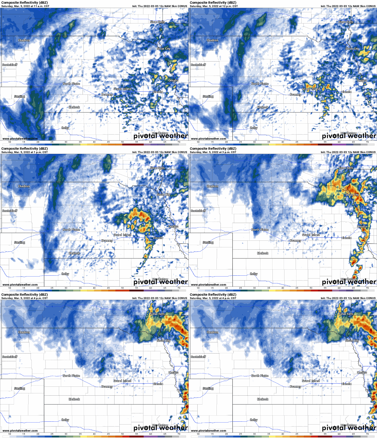
Here is a simulated radar loop for Saturday afternoon from the 12z 3km NAM showing storms forming to our west early Saturday afternoon and moving through Omaha around 3 or 4 PM:
This setup is relatively similar to what happened on December 15th. Like that day, fast-moving storms are likely and tornado development may occur with little or no notice (although damaging wind will be the primary threat for most people). The tornado threat, however, is still conditional and will depend on how high dewpoints are ahead of the low/boundary and if instability is high enough. Just letting people know there is a potential this will be a similar event (though probably not as significant) as December 15th. Yes, Omaha itself dodged the bullet that day but there were several damaging tornadoes all around Omaha.
Assuming these model trends continue, I'd be surprised if the severe weather risk area for Saturday isn't expanded further west to include parts of eastern NE including Omaha. Still plenty of uncertainty though and we will see what model trends show...
Here is a simulated radar loop for Saturday afternoon from the 12z 3km NAM showing storms forming to our west early Saturday afternoon and moving through Omaha around 3 or 4 PM:
-
stormchaser
- Planning Board
- Posts: 2380
- Joined: Fri Jun 01, 2018 1:14 pm
Re: 2022 Weather Thread
Just to clarify, the highest tornado potential currently is south of Omaha from Lincoln to Nebraska City on south to Beatrice and east to Falls City, and then up into adjacent parts of southwest IA/northwest MO based on the 3km NAM and what can be seen so far on the HRRR.
In addition, a "crashing cold front" north of the low is depicted to move through Omaha itself bringing with it mostly damaging wind potential locally. Too far out though still to really know specifics like that though. If the low pressure shifts north even slightly, it could bring a better tornado chance through the metro itself.
I'll post additional updates as we get closer. Certainly continuing to look interesting in the local area though with tornado potential not far away (just south of the metro right now)...
In addition, a "crashing cold front" north of the low is depicted to move through Omaha itself bringing with it mostly damaging wind potential locally. Too far out though still to really know specifics like that though. If the low pressure shifts north even slightly, it could bring a better tornado chance through the metro itself.
I'll post additional updates as we get closer. Certainly continuing to look interesting in the local area though with tornado potential not far away (just south of the metro right now)...
-
stormchaser
- Planning Board
- Posts: 2380
- Joined: Fri Jun 01, 2018 1:14 pm
Re: 2022 Weather Thread
The 00z HRRR is in and has shifted things north and puts Omaha squarely in the area with the highest tornado threat on Saturday. I’d be shocked if the SPC doesn’t include Omaha in a severe risk area and at least a 5% tornado threat (in or near Omaha anyway) assuming model trends continue. This run even pushes dewpoints into the low 60s locally. If that happens, look out…
Last edited by stormchaser on Fri Mar 04, 2022 2:21 am, edited 2 times in total.
-
stormchaser
- Planning Board
- Posts: 2380
- Joined: Fri Jun 01, 2018 1:14 pm
Re: 2022 Weather Thread
Main tornado threat area IMO for Saturday:
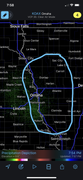
In particular, from near Fremont, Blair, Missouri Valley on northeast. Obviously specifics like this are impossible to know at this point but parameters would support a stronger tornado or 2 in that specific area IF things verified as shown (which they may or may not)…
In particular, from near Fremont, Blair, Missouri Valley on northeast. Obviously specifics like this are impossible to know at this point but parameters would support a stronger tornado or 2 in that specific area IF things verified as shown (which they may or may not)…
-
Brad

- Photographer
- Posts: 1036702
- Joined: Sun Feb 29, 2004 12:03 am
- Location: Omaha, NE
Re: 2022 Weather Thread
What time are you thinking?stormchaser wrote: Fri Mar 04, 2022 1:59 am Main tornado threat area IMO for Saturday:
In particular, from near Fremont, Blair, Missouri Valley on northeast. Obviously specifics like this are impossible to know at this point but parameters would support a stronger tornado or 2 in that specific area IF things verified as shown (which they may or may not)…

Omaha Skyline Photos, Omaha Aerial Photos, and More.
Website: www.bradwilliamsphotography.com
Facebook: www.facebook.com/bradwilliamsphotography
Twitter: www.twitter.com/bradwphoto
Instagram: www.instagram.com/bradwilliamsphotography
YouTube: www.youtube.com/@bradwilliamsphoto
-
stormchaser
- Planning Board
- Posts: 2380
- Joined: Fri Jun 01, 2018 1:14 pm
Re: 2022 Weather Thread
Between 1pm and 4pm in our area currently. Timing obviously could change yet though. I’m assuming this storm system will continue trending slower so putting the risk area even further west/southwest…but who knows. Where ever the triple point ends up will be the most favorable for tornadoes…which is where I’ll be ;)Brad wrote: Fri Mar 04, 2022 2:34 amWhat time are you thinking?stormchaser wrote: Fri Mar 04, 2022 1:59 am Main tornado threat area IMO for Saturday:
In particular, from near Fremont, Blair, Missouri Valley on northeast. Obviously specifics like this are impossible to know at this point but parameters would support a stronger tornado or 2 in that specific area IF things verified as shown (which they may or may not)…
-
Cermak
- Planning Board
- Posts: 2348
- Joined: Thu Nov 29, 2018 7:02 pm
Re: 2022 Weather Thread
If the Omaha area gets a Tornado warning Saturday I believe this will be one of if not the earliest Tornado warning I can recall in our region. Usually this time of year we are still thawing out from a cold winter. This winter we have had maybe 8 inches of snow all winter, last year at this time we had about 40.
Tornado warnings in mid December and now a chance for more tornado warnings in early March. Talk about crazy weather. I’d rather have the snow…
Tornado warnings in mid December and now a chance for more tornado warnings in early March. Talk about crazy weather. I’d rather have the snow…
-
Busguy2010
- City Council
- Posts: 7393
- Joined: Sun Apr 10, 2011 12:32 am
- Location: North Central Omaha
Re: 2022 Weather Thread
That would be frickin' insane. I doubt there are records for earliest or latest tornadoes/tornado warnings in Omaha. December 15th has to be one of, if not the latest. If it were to happen Saturday, I too would have to believe it would be one of, if not the earliest tornadoes or warnings. Very early, but not exactly unheard of, because the 1913 Omaha Tornado was on March 23rd, a lot earlier than one would expect. But for one that late and one that early to happen in consecutive years would be crazy. I vote snow too.Cermak wrote: Fri Mar 04, 2022 4:31 am Tornado warnings in mid December and now a chance for more tornado warnings in early March. Talk about crazy weather. I’d rather have the snow…
-
stormchaser
- Planning Board
- Posts: 2380
- Joined: Fri Jun 01, 2018 1:14 pm
Re: 2022 Weather Thread
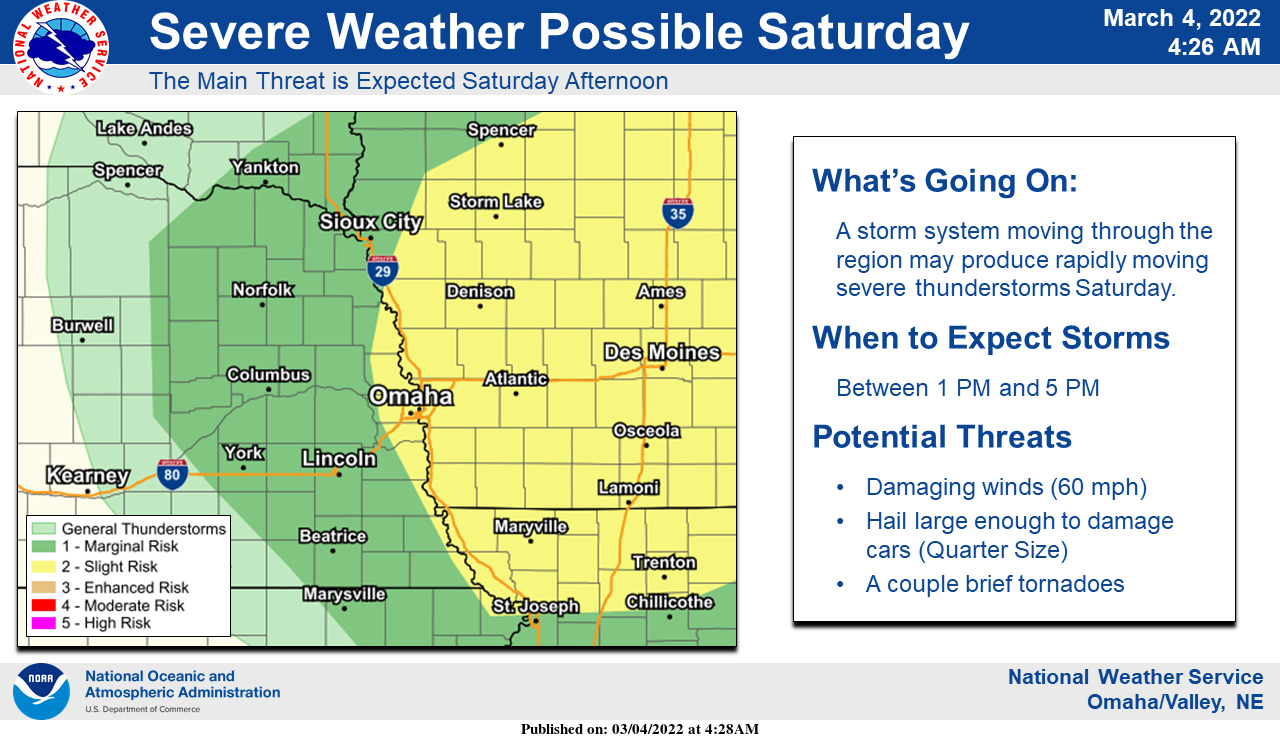
The SPC has shifted the risk area for tomorrow west to include Omaha (barely) and has added a 5% tornado risk area (including Omaha).
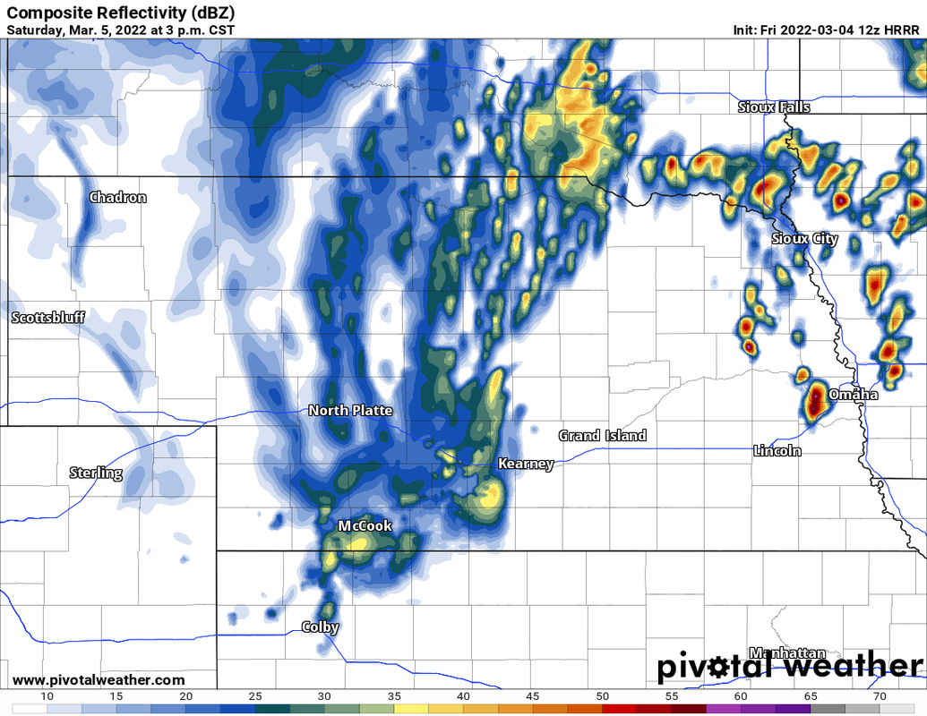
The 12z HRRR continues the theme of supercells developing in and around Omaha tomorrow afternoon. If this happens, isolated tornadoes are possible in Omaha itself (depending on the timing of the development, etc).
12z HRRR shows the triple point moving over (or very close to) Omaha itself with a supercell in that area on the simulated radar. Only time will tell though...
Here is the simulated radar from the 12z HRRR showing the supercell over Omaha around 3 PM.
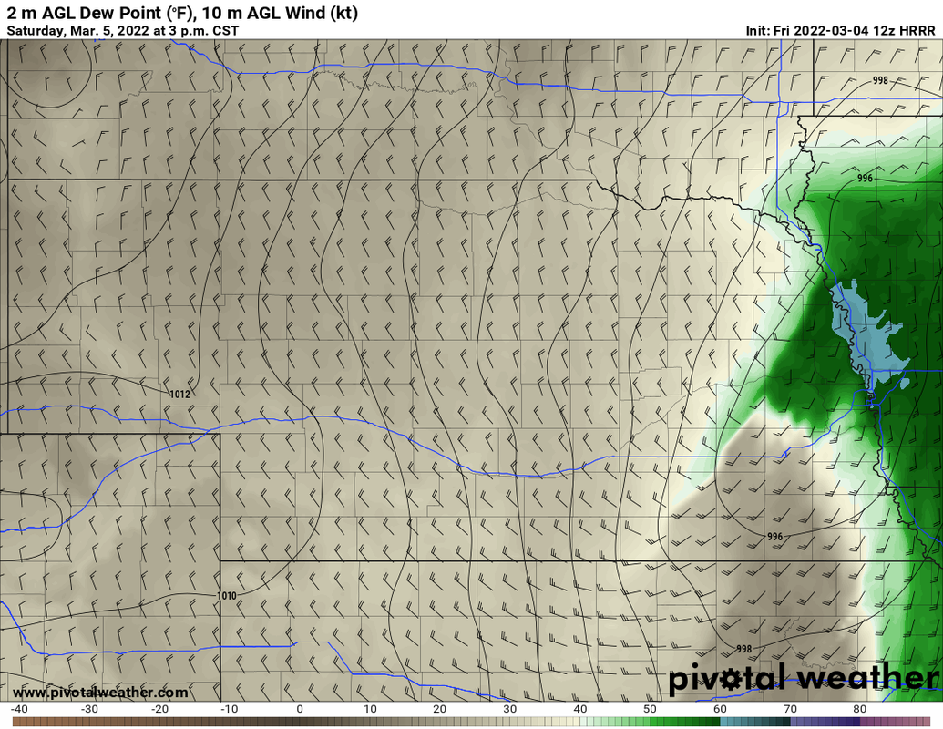
Depicted placement of the low (showing the surface dewpoints) indicating this supercell is right on the area of the low where helicity (rotation) is often maximized and tornado potential is relatively high:
The 12z HRRR continues the theme of supercells developing in and around Omaha tomorrow afternoon. If this happens, isolated tornadoes are possible in Omaha itself (depending on the timing of the development, etc).
12z HRRR shows the triple point moving over (or very close to) Omaha itself with a supercell in that area on the simulated radar. Only time will tell though...
Here is the simulated radar from the 12z HRRR showing the supercell over Omaha around 3 PM.
Depicted placement of the low (showing the surface dewpoints) indicating this supercell is right on the area of the low where helicity (rotation) is often maximized and tornado potential is relatively high:
-
stormchaser
- Planning Board
- Posts: 2380
- Joined: Fri Jun 01, 2018 1:14 pm
Re: 2022 Weather Thread
The westward expansion on the SPC outlook continues with the latest update now including more of eastern NE (not surprised). Unfortunately, Omaha (or very close by) still looks like a "higher" risk area for tornadoes given the depicted placement of the low pressure, etc during peak heating - ultimately it will depend on the timing of exactly when the storms fire if Omaha will be hit or not.
I hope people pay close attention tomorrow in the local area. Most tornadoes will be weak/brief tomorrow but I still feel like there is still at least some chance for a stronger 1 (or 2) out of this setup (odds aren't great for that to happen but it's still possible and it only takes 1 to move through a populated area to cause a catastrophe)...
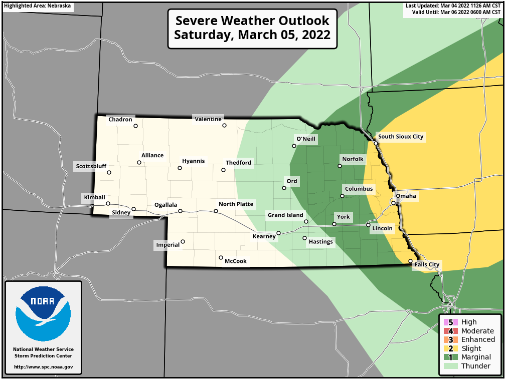
Official text from the latest outlook:
...SUMMARY...
Severe thunderstorms should occur Saturday afternoon and early
evening over Iowa and parts of surrounding states. Large hail,
damaging winds, a few tornadoes all appear possible.
...Central Plains into the Upper Midwest...
A negatively tilted shortwave trough will advance northeastward
across the central Plains, mid/upper MS Valley, and Upper Midwest on
Saturday. This feature should reach the Great Lakes region by the
end of the period. At the surface, a low initially over northern KS
is forecast to develop northeastward in tandem with the shortwave
trough through the day, reaching northern IA and southeastern MN by
early Saturday evening.
A strong, 45-55 kt low-level jet will transport modest moisture
northward from the lower MS Valley and Ozarks to much of IA and
vicinity ahead of the surface low. There appears to be some chance
for warm advection related thunderstorms to occur Saturday morning
and early afternoon. If this convection forms, it may pose an
isolated threat for mainly hail. Otherwise, an arcing band of
convection appears likely to develop by mid to late afternoon
along/near the NE/IA border as pronounced mid-level height falls and
ascent associated with the shortwave trough overspread this region.
These thunderstorms will likely move quickly northeastward across IA
and small portions of the surrounding states. Even with surface
dewpoints generally remaining in the mid 50s, rapidly cooling
temperatures aloft and steepening mid-level lapse rates should aid
in the development of 500-1000 J/kg of MLCAPE ahead of the main band
of convection. Strong deep-layer shear profiles, with 50-60+ of
effective bulk shear forecast, will favor supercells with both a
large hail and damaging wind threat.
Given the strength of the low-level flow expected, favorable shear
in the boundary layer should also support a threat for a few
tornadoes with any supercells that can persist. Some upscale growth
into a broken line may eventually occur, but instability should
gradually weaken with eastward extent into eastern IA and IL/WI
Saturday night. The southern extent of the severe threat into
eastern KS and central MO will probably be confined by residual
convective inhibition, and the stronger ascent attendant to the
shortwave trough generally remaining displaced to the north.
I hope people pay close attention tomorrow in the local area. Most tornadoes will be weak/brief tomorrow but I still feel like there is still at least some chance for a stronger 1 (or 2) out of this setup (odds aren't great for that to happen but it's still possible and it only takes 1 to move through a populated area to cause a catastrophe)...
Official text from the latest outlook:
...SUMMARY...
Severe thunderstorms should occur Saturday afternoon and early
evening over Iowa and parts of surrounding states. Large hail,
damaging winds, a few tornadoes all appear possible.
...Central Plains into the Upper Midwest...
A negatively tilted shortwave trough will advance northeastward
across the central Plains, mid/upper MS Valley, and Upper Midwest on
Saturday. This feature should reach the Great Lakes region by the
end of the period. At the surface, a low initially over northern KS
is forecast to develop northeastward in tandem with the shortwave
trough through the day, reaching northern IA and southeastern MN by
early Saturday evening.
A strong, 45-55 kt low-level jet will transport modest moisture
northward from the lower MS Valley and Ozarks to much of IA and
vicinity ahead of the surface low. There appears to be some chance
for warm advection related thunderstorms to occur Saturday morning
and early afternoon. If this convection forms, it may pose an
isolated threat for mainly hail. Otherwise, an arcing band of
convection appears likely to develop by mid to late afternoon
along/near the NE/IA border as pronounced mid-level height falls and
ascent associated with the shortwave trough overspread this region.
These thunderstorms will likely move quickly northeastward across IA
and small portions of the surrounding states. Even with surface
dewpoints generally remaining in the mid 50s, rapidly cooling
temperatures aloft and steepening mid-level lapse rates should aid
in the development of 500-1000 J/kg of MLCAPE ahead of the main band
of convection. Strong deep-layer shear profiles, with 50-60+ of
effective bulk shear forecast, will favor supercells with both a
large hail and damaging wind threat.
Given the strength of the low-level flow expected, favorable shear
in the boundary layer should also support a threat for a few
tornadoes with any supercells that can persist. Some upscale growth
into a broken line may eventually occur, but instability should
gradually weaken with eastward extent into eastern IA and IL/WI
Saturday night. The southern extent of the severe threat into
eastern KS and central MO will probably be confined by residual
convective inhibition, and the stronger ascent attendant to the
shortwave trough generally remaining displaced to the north.
-
Busguy2010
- City Council
- Posts: 7393
- Joined: Sun Apr 10, 2011 12:32 am
- Location: North Central Omaha
Re: 2022 Weather Thread
Was watching the weather channel and they also had us in a torcon of 3.
I'm thinking the rains and thunder tonight and early tomorrow may be the enjoyable variety at least.
I'm thinking the rains and thunder tonight and early tomorrow may be the enjoyable variety at least.
-
stormchaser
- Planning Board
- Posts: 2380
- Joined: Fri Jun 01, 2018 1:14 pm
Re: 2022 Weather Thread
The tornado threat certainly isn't huge but it's localized and centered in the Omaha area on up into central parts of Iowa (if things verify as shown). I'd be shocked if there isn't a tornado warning in or near Omaha tomorrow to be completely honest.
-
stormchaser
- Planning Board
- Posts: 2380
- Joined: Fri Jun 01, 2018 1:14 pm
Re: 2022 Weather Thread
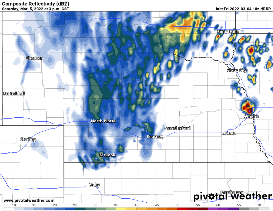
Simulated radar from the 18z HRRR showing a supercell basically over Omaha around 3 PM. IF this happens there is a decent chance this storm would be tornadic.
To clarify the things I've said recently. There are plenty of unknowns yet as far as how things play out tomorrow. One of the bigger unknowns is the fact there will probably be storms tonight and tomorrow morning. How long will it take for that round to move out and for the atmosphere to recover/destabilize will be very important. Right now it looks like there will be time for it to happen...but ultimately, who knows.
To clarify the things I've said recently. There are plenty of unknowns yet as far as how things play out tomorrow. One of the bigger unknowns is the fact there will probably be storms tonight and tomorrow morning. How long will it take for that round to move out and for the atmosphere to recover/destabilize will be very important. Right now it looks like there will be time for it to happen...but ultimately, who knows.
-
stormchaser
- Planning Board
- Posts: 2380
- Joined: Fri Jun 01, 2018 1:14 pm
Re: 2022 Weather Thread
Much needed heavy rain moving through Omaha currently with more expected into tomorrow. Then a break before redevelopment occurs sometime in the 1pm-3pm time frame.
Outlined below is where I think the greatest tornado threat area will be Saturday. Omaha it still depends when and how quickly storms develop if there will be a threat specifically here in the metro. Right now the higher risk is probably just east of town though (but it’s very close).
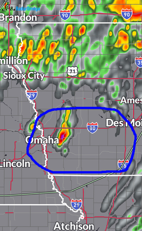
Outlined below is where I think the greatest tornado threat area will be Saturday. Omaha it still depends when and how quickly storms develop if there will be a threat specifically here in the metro. Right now the higher risk is probably just east of town though (but it’s very close).
-
Busguy2010
- City Council
- Posts: 7393
- Joined: Sun Apr 10, 2011 12:32 am
- Location: North Central Omaha
Re: 2022 Weather Thread
Now that storm we had between 11 and 12 was just perfect. A fair amount on rain, lightning, and thunder, but not too intense. Just gentle enough to stand outside and watch, but just interesting enough to stay outside and watch. I stayed outside on the porch almost the whole hour.
-
skinzfan23
- City Council
- Posts: 11671
- Joined: Mon Feb 09, 2004 5:26 pm
- Location: Omaha/Bellevue
Re: 2022 Weather Thread
We ended up with .80 in of rain in Bellevue just from tonight’s storm, that was unexpected and nice to see along with the non-severe thunderstorm!
-
stormchaser
- Planning Board
- Posts: 2380
- Joined: Fri Jun 01, 2018 1:14 pm
Re: 2022 Weather Thread
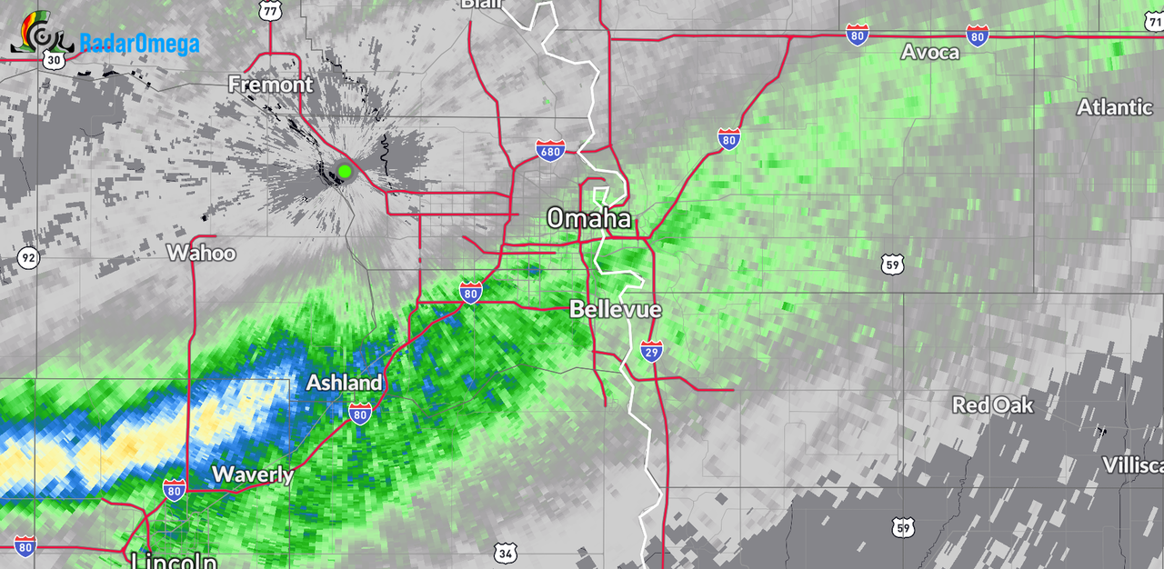
Yep, nice area of heavier rain moved through the southern half of the metro bringing with it rain totals up to an inch. Some areas north of Lincoln ended up with over 2 inches of rain. As you can see, the storm/rain was dying out as it moved into Omaha (and died almost completely east of town)skinzfan23 wrote: Sat Mar 05, 2022 7:56 am We ended up with .80 in of rain in Bellevue just from tonight’s storm, that was unexpected and nice to see along with the non-severe thunderstorm!
-
stormchaser
- Planning Board
- Posts: 2380
- Joined: Fri Jun 01, 2018 1:14 pm
Re: 2022 Weather Thread
Still looks like severe storm development will occur in or near Omaha around 2 or 3 PM. However, tornado potential will probably mostly end up east of Omaha since the storms probably won't be fully mature before they pass east of here. All of this continues to be contingent on how quickly the atmosphere can recover after storms/precip moves through the area later this morning (though right now it looks like most of the morning precip will pass south of here)...
-
GetUrban
- Planning Board
- Posts: 2650
- Joined: Sun Nov 23, 2008 9:07 pm
- Location: Omaha
Re: 2022 Weather Thread
It was such a welcome site awaking to fog and seeing everything turned to a darker shade of brown with subtle underlying hints of green appearing on the rain-soaked ground. We needed that.
He said "They are some big, ugly red brick buildings"
...and then they were gone.
...and then they were gone.
-
Cermak
- Planning Board
- Posts: 2348
- Joined: Thu Nov 29, 2018 7:02 pm
Re: 2022 Weather Thread
Never thought I would be this excited About a little rain. It was nice hearing the sound of it as well.
-
stormchaser
- Planning Board
- Posts: 2380
- Joined: Fri Jun 01, 2018 1:14 pm
Re: 2022 Weather Thread
My initial target today is near Shenandoah, IA (probably northeast of town). Storm re-development (after this current round) looks to occur early this afternoon near the NE/IA/MO border on north to near Omaha and move east/northeast from there. This storm should move up toward the Red Oak/Atlantic area (I want to stay east/southeast of the storm to start out and the road network is decent in that area).
Target is based on current mesoanalysis data, surface data, visible satellite and short range models (HRRR specifically). A tornado or 2 is possible but not a huge threat…as well as hail/wind. Fast moving storms will make it a difficult chase…
Target is based on current mesoanalysis data, surface data, visible satellite and short range models (HRRR specifically). A tornado or 2 is possible but not a huge threat…as well as hail/wind. Fast moving storms will make it a difficult chase…
-
Busguy2010
- City Council
- Posts: 7393
- Joined: Sun Apr 10, 2011 12:32 am
- Location: North Central Omaha
Re: 2022 Weather Thread
I'm having lots of trouble seeing anything more than what we saw last night. What was supposed to be a high of almost 75 today has been slashed to 59. Could get a brief unexpected EF 0-1 somewhere, much akin to the April 27, 2016 west Omaha tornado, when conditions were pretty similar. But it just doesn't seem likely in Omaha after all the rain and cooling we've had.
-
stormchaser
- Planning Board
- Posts: 2380
- Joined: Fri Jun 01, 2018 1:14 pm
Re: 2022 Weather Thread
Omaha itself is in the clear (as far as tornadoes anyway) since the boundary has pushed through here already. Southeast of town is still at risk though which is where I’m headingBusguy2010 wrote: Sat Mar 05, 2022 5:20 pm I'm having lots of trouble seeing anything more than what we saw last night. What was supposed to be a high of almost 75 today has been slashed to 59. Could get a brief unexpected EF 0-1 somewhere, much akin to the April 27, 2016 west Omaha tornado, when conditions were pretty similar. But it just doesn't seem likely in Omaha after all the rain and cooling we've had.

-
stormchaser
- Planning Board
- Posts: 2380
- Joined: Fri Jun 01, 2018 1:14 pm
Re: 2022 Weather Thread
Biggest question is if the atmosphere will recover in time southeast of Omaha with ongoing rain in the area. However, parts of southeast NE and southwest IA have cleared off so things should destabilize fairly quick…hard to say if it will be enough though
-
stormchaser
- Planning Board
- Posts: 2380
- Joined: Fri Jun 01, 2018 1:14 pm
Re: 2022 Weather Thread
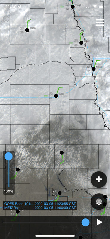
Based on surface date and visible satellite, it will recover southeast of Omaha. Things have cleared off and agitated cumulus have started forming near the NE/KS border meaning storm re-development will likely occur near the NE/IA border in a couple hours as this area moves northeast into southwest IA. Severe storms are fairly likely in this area but it’s unclear if the lower levels will destabilize enough for tornadoes (just to clarify)…
-
Busguy2010
- City Council
- Posts: 7393
- Joined: Sun Apr 10, 2011 12:32 am
- Location: North Central Omaha
Re: 2022 Weather Thread
I will actually be totally surprised if it even gets to 59 now. I could see barely breaking 50.
-
stormchaser
- Planning Board
- Posts: 2380
- Joined: Fri Jun 01, 2018 1:14 pm
Re: 2022 Weather Thread
Doubtful it will in Omaha, temps will likely start dropping since the boundary has pushed through (though it’s barely southeast of town…Busguy2010 wrote: Sat Mar 05, 2022 5:42 pm I will actually be totally surprised if it even gets to 59 now. I could see barely breaking 50.
-
stormchaser
- Planning Board
- Posts: 2380
- Joined: Fri Jun 01, 2018 1:14 pm
Re: 2022 Weather Thread
Tornado watch will likely be issued soon just east/southeast of Omaha:
More info:
https://www.spc.noaa.gov/products/md/md0194.html
More info:
https://www.spc.noaa.gov/products/md/md0194.html
-
Cermak
- Planning Board
- Posts: 2348
- Joined: Thu Nov 29, 2018 7:02 pm
Re: 2022 Weather Thread
Seems to cold for Tornadoes in Omaha. I was out this morning at 9am and it just didn’t feel like Tornado weather to me. While the December 15th storm felt like a spring day and potentially ripe for severe weather. Next week looks colder, wonder if we will get some snow. Winter may not be done yet.
-
Busguy2010
- City Council
- Posts: 7393
- Joined: Sun Apr 10, 2011 12:32 am
- Location: North Central Omaha
Re: 2022 Weather Thread
Right now NWS calling for about .5" of snow tomorrow night.
Tornado east of Red Oak right now. Looked like it could have been EF 1 or 2.
Tornado east of Red Oak right now. Looked like it could have been EF 1 or 2.
-
Brad
- Photographer
- Posts: 1036702
- Joined: Sun Feb 29, 2004 12:03 am
- Location: Omaha, NE
Re: 2022 Weather Thread
Went down to Loess Bluffs this morning and experienced all kinds of weather. Everything from bright sun to really cool fog rising out of the bluffs. Wish I had a little more time to enjoy it. Had a decent cell (Non-severe) pop up over us on the way back.
Omaha Skyline Photos, Omaha Aerial Photos, and More.
Website: www.bradwilliamsphotography.com
Facebook: www.facebook.com/bradwilliamsphotography
Twitter: www.twitter.com/bradwphoto
Instagram: www.instagram.com/bradwilliamsphotography
YouTube: www.youtube.com/@bradwilliamsphoto
-
stormchaser
- Planning Board
- Posts: 2380
- Joined: Fri Jun 01, 2018 1:14 pm
Re: 2022 Weather Thread
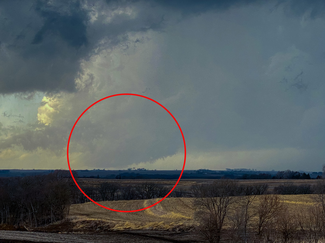
Looks like my forecast/target verified that I posted earlier. Storms fired near the NE/IA border. I targeted just northeast of Shenandoah, IA, and followed the storm up toward Red Oak where I saw a ground scraping rotating wall cloud southwest of Red Oak though I didn't see any debris kick up so I'm assuming it didn't touch down - but it was basically on the ground so who knows. I'm pretty sure this would have turned into a wedge if the lower levels weren't stabilized from the earlier storms though. Lost the storm once I got into Red Oak so called it a day...Busguy2010 wrote: Sat Mar 05, 2022 9:44 pm Right now NWS calling for about .5" of snow tomorrow night.
Tornado east of Red Oak right now. Looked like it could have been EF 1 or 2.
Here is a photo:
-
stormchaser
- Planning Board
- Posts: 2380
- Joined: Fri Jun 01, 2018 1:14 pm
Re: 2022 Weather Thread
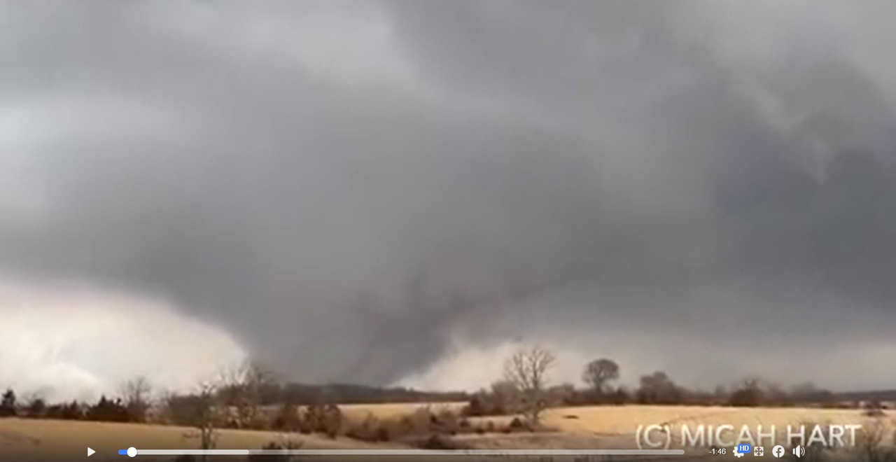
Strong/damaging tornado from southwest of Des Moines a short time ago. Hope everyone is safe...
Video:
Screenshot:
Video:
Screenshot:
-
Brad
- Photographer
- Posts: 1036702
- Joined: Sun Feb 29, 2004 12:03 am
- Location: Omaha, NE
Re: 2022 Weather Thread
Wow, impressive
Omaha Skyline Photos, Omaha Aerial Photos, and More.
Website: www.bradwilliamsphotography.com
Facebook: www.facebook.com/bradwilliamsphotography
Twitter: www.twitter.com/bradwphoto
Instagram: www.instagram.com/bradwilliamsphotography
YouTube: www.youtube.com/@bradwilliamsphoto