2022 Weather Thread
-
Louie
- County Board
- Posts: 4968
- Joined: Fri Dec 23, 2011 10:23 pm
- Location: Dundee
Re: 2022 Weather Thread
Its windy as heck today
-
Busguy2010

- City Council
- Posts: 7393
- Joined: Sun Apr 10, 2011 12:32 am
- Location: North Central Omaha
Re: 2022 Weather Thread
So the temperature trended downward. Kind of surprisingly chilly today and tomorrow and it looks like we actually are going to get a little bit of "snow" out of it.
-
Busguy2010
- City Council
- Posts: 7393
- Joined: Sun Apr 10, 2011 12:32 am
- Location: North Central Omaha
Re: 2022 Weather Thread
Very interesting precipitation right now. Text book definition of grauple. I cant lie, its kinda miserable out right now, but I like it better than warm and sunny. I'll take this weather over no weather to speak of at all.
-
Brad

- Photographer
- Posts: 1036702
- Joined: Sun Feb 29, 2004 12:03 am
- Location: Omaha, NE
Re: 2022 Weather Thread
I drove to Lincoln today and literally had everything.... Rain, Snow, Sleet, Ice Pellets, Graupel, and anything else you can find.Busguy2010 wrote: Thu Apr 07, 2022 7:27 pm Very interesting precipitation right now. Text book definition of grauple. I cant lie, its kinda miserable out right now, but I like it better than warm and sunny. I'll take this weather over no weather to speak of at all.
And the wind made all of the frozen varieties even worse. My car isn't the best in strong winds at interstate speeds to I took Highway 6. I encountered a dust storm with near zero visibility and I was passed by a coal train where you could see coal dust blowing out of the train. It literally sand blasted my car the entire time I was next to it.
Today sucked, I would take no wind over warmth at this point...

Omaha Skyline Photos, Omaha Aerial Photos, and More.
Website: www.bradwilliamsphotography.com
Facebook: www.facebook.com/bradwilliamsphotography
Twitter: www.twitter.com/bradwphoto
Instagram: www.instagram.com/bradwilliamsphotography
YouTube: www.youtube.com/@bradwilliamsphoto
-
Busguy2010
- City Council
- Posts: 7393
- Joined: Sun Apr 10, 2011 12:32 am
- Location: North Central Omaha
Re: 2022 Weather Thread
The wind was the worst part about today IMO. Without wind, it might have been a half-decent wintry day. I enjoyed the temperature and the rain and snowy precipitation, but not the windchill.
-
stormchaser
- Planning Board
- Posts: 2380
- Joined: Fri Jun 01, 2018 1:14 pm
Re: 2022 Weather Thread
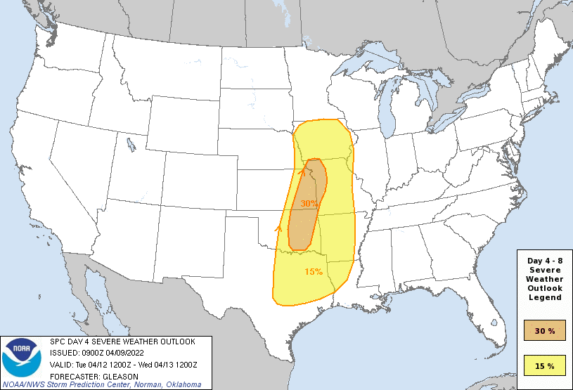
As I mentioned nearly a week ago, severe weather continues to look possible in parts of our area both Tuesday and Wednesday including the threat for damaging wind, large hail, and a few tornadoes.
However, the main threat on Tuesdays for severe weather/potential tornadoes will likely be east/southeast of Omaha - mostly where the "enhanced risk" is where a dryline is expected to be the focus for supercell development (though there may be scattered severe storms in our area too depending on the timing of storm development).
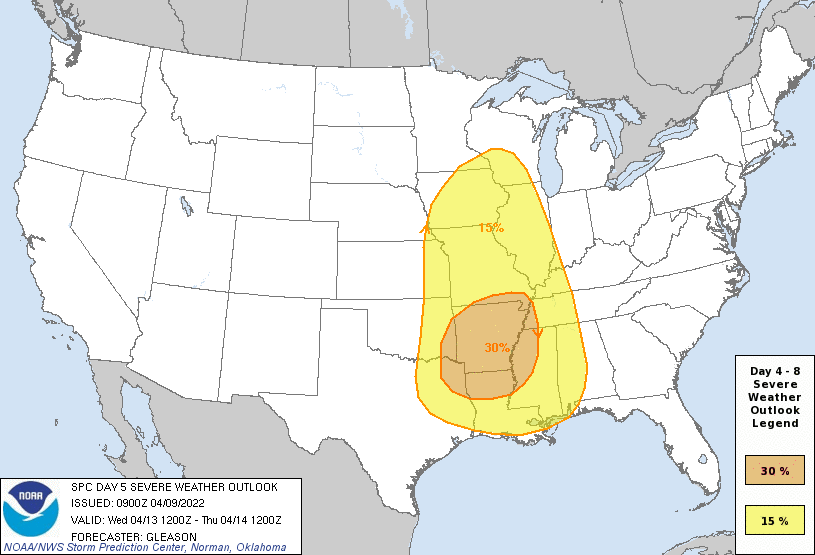
On Wednesday, much of the threat will likely be into Iowa though it again depends on the timing of storm development and how quickly the low pressure pushes through. If the low trends slower (which is relatively common as we get closer to the day itself), Wednesday could be the main severe weather day for Omaha itself.
Like normal for these setups and the scattered nature of storms, odds are WAY higher that Omaha itself will be missed. Regardless, people need to keep a close eye on things both days.
Current Day 4 Outlook (for Tuesday):
Current Day 5 Outlook (for Wednesday):
However, the main threat on Tuesdays for severe weather/potential tornadoes will likely be east/southeast of Omaha - mostly where the "enhanced risk" is where a dryline is expected to be the focus for supercell development (though there may be scattered severe storms in our area too depending on the timing of storm development).
On Wednesday, much of the threat will likely be into Iowa though it again depends on the timing of storm development and how quickly the low pressure pushes through. If the low trends slower (which is relatively common as we get closer to the day itself), Wednesday could be the main severe weather day for Omaha itself.
Like normal for these setups and the scattered nature of storms, odds are WAY higher that Omaha itself will be missed. Regardless, people need to keep a close eye on things both days.
Current Day 4 Outlook (for Tuesday):
Current Day 5 Outlook (for Wednesday):
-
Omaha Cowboy

- The Don
- Posts: 1013737
- Joined: Wed Jan 07, 2004 11:31 am
- Location: West Omaha
Re: 2022 Weather Thread
At least we’re past the last several days of crappy weather..
Just in time for some great weather to enjoy this weekend …
Ciao..LiO…Peace
Just in time for some great weather to enjoy this weekend
…Ciao..LiO…Peace
Go Cowboys!
-
stormchaser
- Planning Board
- Posts: 2380
- Joined: Fri Jun 01, 2018 1:14 pm
Re: 2022 Weather Thread
Tuesday evening/night has definitely now become the primary severe weather risk day for Omaha itself with things shifting well east of Omaha on Wednesday. To clarify, much of the storm activity won’t develop until near/after dark on Tuesday so don’t be caught off guard because most of the day is quiet
Unfortunately odds have increased that this will be a relatively dangerous day for the local area including a threat for strong tornadoes (mostly after dark making things that much more dangerous).
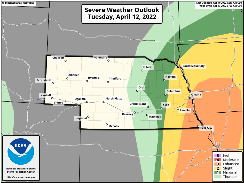
The SPC has added Omaha to an enhanced risk (albeit in the very edge for now). Based on model trends this morning, I’d expect more of our local area to be upgraded though and the potential for further upgrades (possibly to a moderate risk) in the coming days.
In addition to the threat for tornadoes (some possibly strong), damaging wind and very large/damaging hail will be possible.
Here is the most recent day 3 SPC outlook for our area:
Unfortunately odds have increased that this will be a relatively dangerous day for the local area including a threat for strong tornadoes (mostly after dark making things that much more dangerous).
The SPC has added Omaha to an enhanced risk (albeit in the very edge for now). Based on model trends this morning, I’d expect more of our local area to be upgraded though and the potential for further upgrades (possibly to a moderate risk) in the coming days.
In addition to the threat for tornadoes (some possibly strong), damaging wind and very large/damaging hail will be possible.
Here is the most recent day 3 SPC outlook for our area:
-
stormchaser
- Planning Board
- Posts: 2380
- Joined: Fri Jun 01, 2018 1:14 pm
Re: 2022 Weather Thread
Text from the day 3 outlook from the SPC reinforcing the potential for strong tornadoes:
Farther north across the central Plains into the mid MO Valley where
low-level moisture will not be quite as rich/deep, convective
initiation may be delayed until late Tuesday evening as the ascent
preceding the surface low overspreads this region. Still, this
region will have stronger mid-level winds and enough effective bulk
shear to support supercell structures with any cells that can form
along/ahead of the dryline and cold front. All severe hazards will
be a threat, including very large hail, damaging winds, and
tornadoes. A rapidly strengthening low-level jet Tuesday
evening/night will enhance the low-level shear, and a couple of
strong tornadoes may occur if thunderstorms can remain at least
semi-discrete. With time, convection may grow upscale into a squall
line Tuesday night and pose more of a severe/damaging wind threat
with eastward extent across IA into eastern KS and MO. Some elevated
hail may also occur to the north of the warm front given the steep
mid-level lapse rates that should be present.
Source: https://www.spc.noaa.gov/products/outlook/day3otlk.html
Farther north across the central Plains into the mid MO Valley where
low-level moisture will not be quite as rich/deep, convective
initiation may be delayed until late Tuesday evening as the ascent
preceding the surface low overspreads this region. Still, this
region will have stronger mid-level winds and enough effective bulk
shear to support supercell structures with any cells that can form
along/ahead of the dryline and cold front. All severe hazards will
be a threat, including very large hail, damaging winds, and
tornadoes. A rapidly strengthening low-level jet Tuesday
evening/night will enhance the low-level shear, and a couple of
strong tornadoes may occur if thunderstorms can remain at least
semi-discrete. With time, convection may grow upscale into a squall
line Tuesday night and pose more of a severe/damaging wind threat
with eastward extent across IA into eastern KS and MO. Some elevated
hail may also occur to the north of the warm front given the steep
mid-level lapse rates that should be present.
Source: https://www.spc.noaa.gov/products/outlook/day3otlk.html
-
Busguy2010
- City Council
- Posts: 7393
- Joined: Sun Apr 10, 2011 12:32 am
- Location: North Central Omaha
Re: 2022 Weather Thread
I'll be happy about the dew point going up so. NWS says they will reach the low 50's. But it's been so dry this winter and now my skin is begging for reprieve.
-
stormchaser
- Planning Board
- Posts: 2380
- Joined: Fri Jun 01, 2018 1:14 pm
Re: 2022 Weather Thread
Dewpoints should reach into the 60s on Tuesday in Omaha - by late afternoon/evening anyway ahead of the storms. Not sure where the NWS is getting those numbers but severe weather would be unlikely (let alone potential strong tornadoes) with dewpoints only in the low 50s - not to mention all models agree with low/mid 60s ahead of the low/cold front Tuesday evening. Wonder if it’s just a glitch on their part (I looked and can confirm it shows that but it doesn’t make any sense)? Odd anyway…but unless things completely change(unlikely at this point), extremely unlikely they will be that low…Busguy2010 wrote: Sun Apr 10, 2022 6:06 pm I'll be happy about the dew point going up so. NWS says they will reach the low 50's. But it's been so dry this winter and now my skin is begging for reprieve.
-
Busguy2010
- City Council
- Posts: 7393
- Joined: Sun Apr 10, 2011 12:32 am
- Location: North Central Omaha
Re: 2022 Weather Thread
I won't get complacent, but maybe they know about the OmaDome. We will see as the days progress. Anyway, that's pretty early to be in the enhanced risk.
-
stormchaser
- Planning Board
- Posts: 2380
- Joined: Fri Jun 01, 2018 1:14 pm
Re: 2022 Weather Thread
Yep, latest models put Omaha itself at a higher risk too. Only time will tell…Busguy2010 wrote: Sun Apr 10, 2022 11:12 pm I won't get complacent, but maybe they know about the OmaDome. We will see as the days progress. Anyway, that's pretty early to be in the enhanced risk.
-
stormchaser
- Planning Board
- Posts: 2380
- Joined: Fri Jun 01, 2018 1:14 pm
Re: 2022 Weather Thread
Based on the 00z 3km NAM, more of eastern NE will be at risk on Tuesday.
Something to keep an eye on but don’t be surprised if the SPC outlook is shifted to include more of eastern NE.
Something to keep an eye on but don’t be surprised if the SPC outlook is shifted to include more of eastern NE.
Last edited by stormchaser on Mon Apr 11, 2022 11:12 am, edited 1 time in total.
-
stormchaser
- Planning Board
- Posts: 2380
- Joined: Fri Jun 01, 2018 1:14 pm
Re: 2022 Weather Thread
Based on the 06z HRRR, severe storms will develop near Omaha around 8-9 PM tomorrow evening and push through the area between 9 and 10 PM bringing with them damaging wind, large hail, and a threat of tornadoes. The next few runs of the HRRR will need to be watched closely though as I feel short-range models don't have a great handle on timing/storm mode yet (so I'll post an additional update once the 12z run is in).
9 PM:
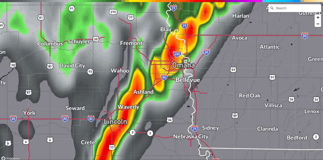
10 PM:
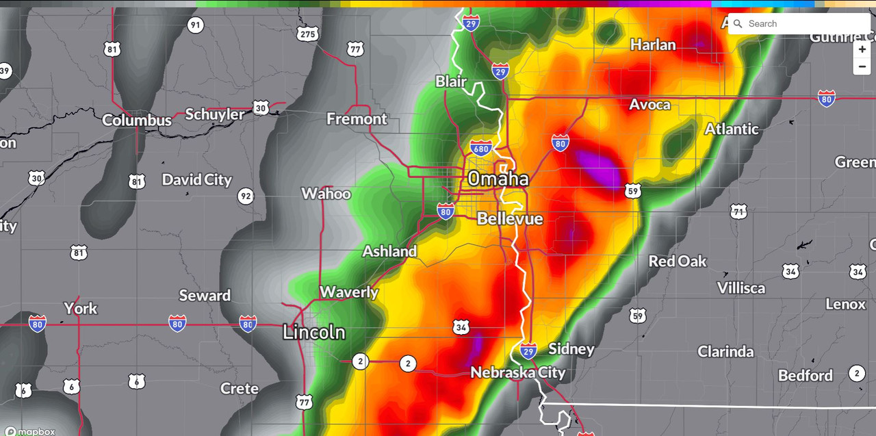
The SPC has increased the severe threat in the area with Omaha now being included in a 10% tornado threat (which is relatively high) and included more into the "enhanced risk" area. These storms may end up being embedded supercells so potentially rain-wrapped, nighttime tornadoes which would be particularly dangerous.
Latest SPC outlook for tomorrow:
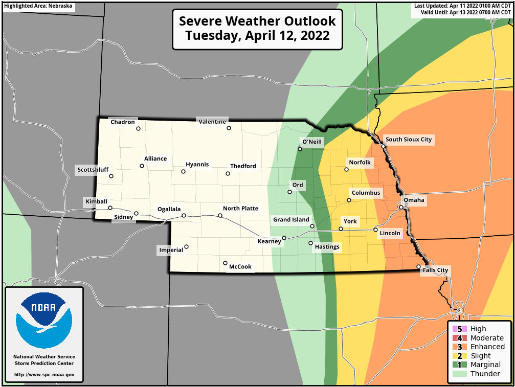
That said, I still feel the higher tornado risk is still probably north of Omaha (closer to where the low will be). Short-range models don't have a great handle yet on timing/storm mode for tomorrow so plenty of things still could change. Regardless, it definitely looks like potentially a dangerous evening tomorrow in our area.
9 PM:
10 PM:
The SPC has increased the severe threat in the area with Omaha now being included in a 10% tornado threat (which is relatively high) and included more into the "enhanced risk" area. These storms may end up being embedded supercells so potentially rain-wrapped, nighttime tornadoes which would be particularly dangerous.
Latest SPC outlook for tomorrow:
That said, I still feel the higher tornado risk is still probably north of Omaha (closer to where the low will be). Short-range models don't have a great handle yet on timing/storm mode for tomorrow so plenty of things still could change. Regardless, it definitely looks like potentially a dangerous evening tomorrow in our area.
-
damonhynes

- Parks & Recreation
- Posts: 1282
- Joined: Wed Aug 27, 2014 12:35 am
- Location: Montgomery County, Texas
Re: 2022 Weather Thread
Lord Rusty reminded us that those cells that form ahead of the line will be the ones to watch for TORs, 6P-9P. Then the linear stuff shows up 9P-12M.
-
stormchaser
- Planning Board
- Posts: 2380
- Joined: Fri Jun 01, 2018 1:14 pm
Re: 2022 Weather Thread
Yeah, I'd agree with that. Either way, the line will likely have embedded supercells with some tornado threat too after dark but the main strong tornado threat locally will be any storms that can form ahead of the line and/or remain discrete.damonhynes wrote: Mon Apr 11, 2022 1:09 pm Lord Rusty reminded us that those cells that form ahead of the line will be the ones to watch for TORs, 6P-9P. Then the linear stuff shows up 9P-12M.
Right now, the highest tornado risk is near Carroll, IA (roughly). I wouldn’t be surprised to see the SPC upgrade this area (and areas north/northwest of Des Moines) to a higher tornado risk and possibly a moderate risk.
Regardless, going to be a dangerous evening in our area.
-
stormchaser
- Planning Board
- Posts: 2380
- Joined: Fri Jun 01, 2018 1:14 pm
Re: 2022 Weather Thread
It also will be interesting - the 12z hrrr has the highest tornado threat northwest of Des Moines. The 12z 3km has it northwest of Omaha. I’m assuming it will be somewhere in the middle just north of Omaha…
-
Busguy2010
- City Council
- Posts: 7393
- Joined: Sun Apr 10, 2011 12:32 am
- Location: North Central Omaha
Re: 2022 Weather Thread
Nws still holding at low to mid 50s for dew points. But temperature projected up to 82 is a trend upward.
-
stormchaser
- Planning Board
- Posts: 2380
- Joined: Fri Jun 01, 2018 1:14 pm
Re: 2022 Weather Thread
Yeah, I now see what they are looking at. The HRRR is depicting the dry line setting up very close to Omaha. East of this dry line, dewpoints will be in the 60s. West of it, likely low 50s (or less). It will ultimately depend on where this dry line ends up if dewpoints get into the 60s locally and if Omaha itself will see storms/severe weather.Busguy2010 wrote: Tue Apr 12, 2022 2:16 am Nws still holding at low to mid 50s for dew points. But temperature projected up to 82 is a trend upward.
-
Omaha Cowboy
- The Don
- Posts: 1013737
- Joined: Wed Jan 07, 2004 11:31 am
- Location: West Omaha
Re: 2022 Weather Thread
Bill Randby tonight, expressed doubt that the dew points would get high enough (in the 60’s) to spawn severe weather in the Omaha area..stormchaser wrote: Tue Apr 12, 2022 2:43 am Yeah, I now see what they are looking at. The HRRR is depicting the dry line setting up very close to Omaha. East of this dry line, dewpoints will be in the 60s. West of it, likely low 50s (or less). It will ultimately depend on where this dry line ends up if dewpoints get into the 60s locally and if Omaha itself will see storms/severe weather.
We’ll see…
Ciao..LiO…Peace
Go Cowboys!
-
stormchaser
- Planning Board
- Posts: 2380
- Joined: Fri Jun 01, 2018 1:14 pm
Re: 2022 Weather Thread
Depends, if the HRRR verifies (which tends to be pretty reliable), then Omaha will dodge the bullet and all of the severe weather will stay in Iowa due to a wedge of dry air pushing east into our area (and consequently shifting the dry line east of us). If the 3km NAM verifies, Omaha will be hit though. Lots of uncertainty considering how close to the event we are now. Wouldn’t be surprised at all if we get missed though. Only time will tell how things actually play out…Omaha Cowboy wrote: Tue Apr 12, 2022 4:06 amBill Randby tonight, expressed doubt that the dew points would get high enough (in the 60’s) to spawn severe weather in the Omaha area..stormchaser wrote: Tue Apr 12, 2022 2:43 am Yeah, I now see what they are looking at. The HRRR is depicting the dry line setting up very close to Omaha. East of this dry line, dewpoints will be in the 60s. West of it, likely low 50s (or less). It will ultimately depend on where this dry line ends up if dewpoints get into the 60s locally and if Omaha itself will see storms/severe weather.
We’ll see…
Ciao..LiO…Peace
-
stormchaser
- Planning Board
- Posts: 2380
- Joined: Fri Jun 01, 2018 1:14 pm
Re: 2022 Weather Thread
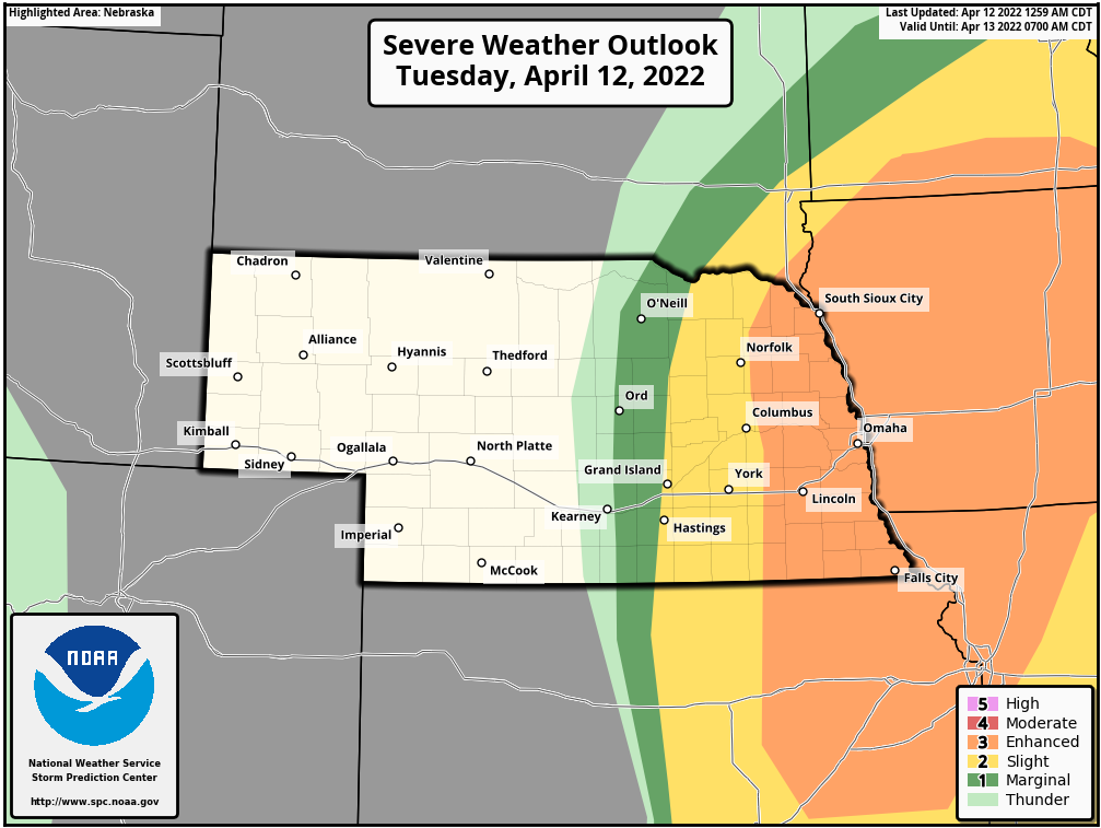
Latest SPC outlook actually has shifted the enhanced risk/higher tornado risk west into more of eastern NE. This tells me they are not convinced the scenario shown on the HRRR (and referenced by Randby) is what will happen.
Long story short, please don’t let down your guard later today. Keeping a close eye on dewpoints should tell us a lot about what to expect locally (if they push into the 60s, we will be at risk). If the 3km NAM verifies, could be a rough evening.
Latest SPC outlook:
Long story short, please don’t let down your guard later today. Keeping a close eye on dewpoints should tell us a lot about what to expect locally (if they push into the 60s, we will be at risk). If the 3km NAM verifies, could be a rough evening.
Latest SPC outlook:
Last edited by stormchaser on Tue Apr 12, 2022 12:59 pm, edited 1 time in total.
-
stormchaser
- Planning Board
- Posts: 2380
- Joined: Fri Jun 01, 2018 1:14 pm
Re: 2022 Weather Thread
This is why today's forecast is so difficult. The exact placement of the dryline will be CRUCIAL if Omaha will get storms/potential tornadoes this evening. The primary risk for strong tornadoes today is in northern IA (just to clarify).
HRRR Forecast Model:
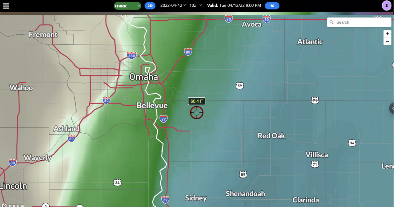
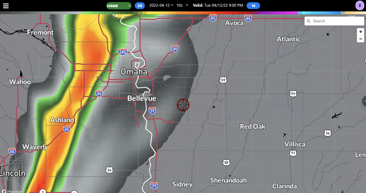
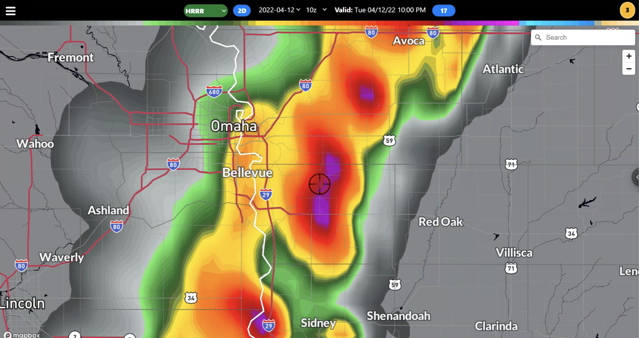
This model has the dryline further east than what the 3km NAM is showing. Initially, the dryline is east of Omaha but throughout the evening it gradually retreats west into the eastern half of Omaha. As this happens, storms are expected to develop between 8 - 9 PM and quickly become severe, very close to or right on top of the metro. Risks will include large damaging hail, damaging wind, and a few tornadoes in the area.
Depicted dewpoints based on the 11z HRRR for 9 PM:
Simulated radar based on the 11z HRRR for 9 PM showing storms initiating in western Omaha:
Simulated radar based on the 11z HRRR for 10 PM showing mature storms/embedded supercells just east of Omaha:
-----------------------
3km NAM Forecast Model:
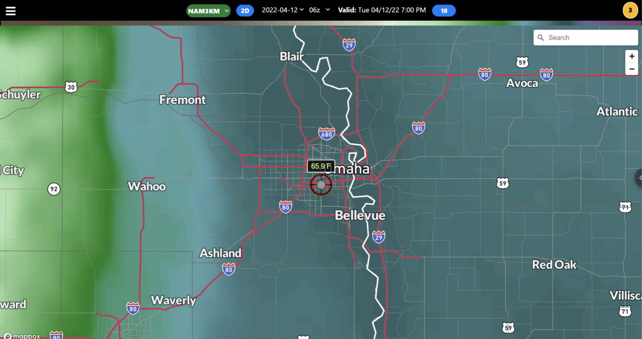
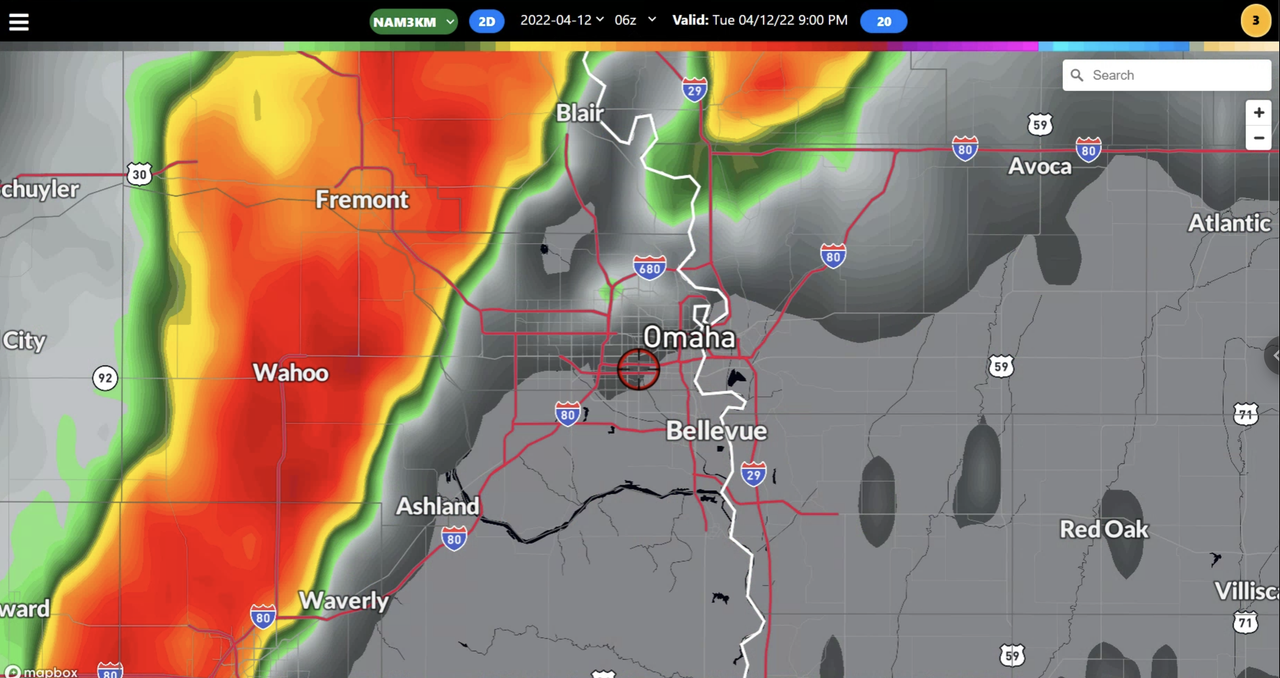
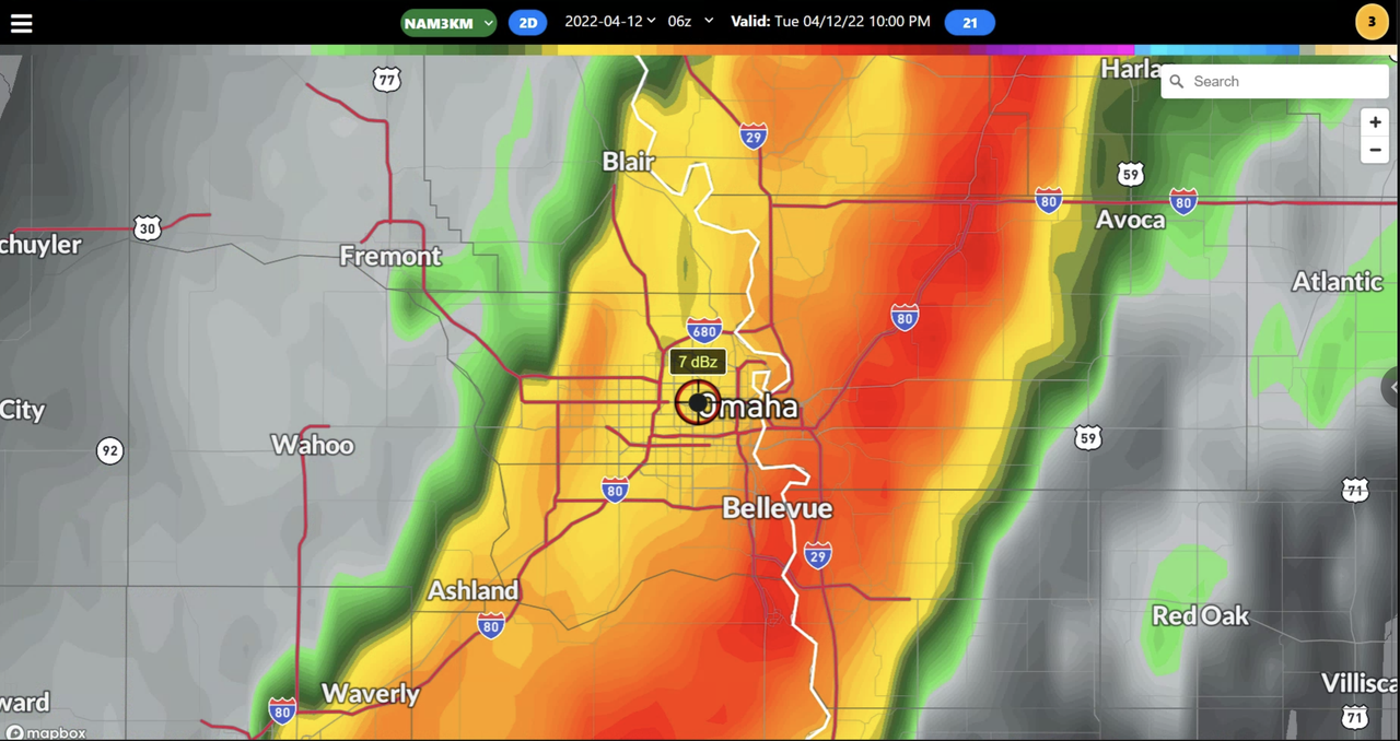
This model has the dryline further west located west of Omaha by the time the storms develop. If this happens, Omaha will be at higher risk for severe weather/potential tornadoes with a line of storms that would develop and move east. However, this model favors more of a damaging wind event for the local area too.
Depicted dewpoints based on the 06z 3km NAM for 7 PM showing the dryline well west of Omaha:
Simulated radar based on the 06z 3km NAM for 9 PM:
Simulated radar based on the 06z 3km NAM for 10 PM:
-----------------------
Long story short, this is a challenging forecast for our area. Omaha itself very well may dodge the bullet depending on exactly where that dryline sets up (which is almost impossible to know at this point). If it does get missed, I can only imagine the number of people whining about how "weather people are clueless" though (like normal) when in reality, forecasting things like this is nearly impossible.
HRRR Forecast Model:
This model has the dryline further east than what the 3km NAM is showing. Initially, the dryline is east of Omaha but throughout the evening it gradually retreats west into the eastern half of Omaha. As this happens, storms are expected to develop between 8 - 9 PM and quickly become severe, very close to or right on top of the metro. Risks will include large damaging hail, damaging wind, and a few tornadoes in the area.
Depicted dewpoints based on the 11z HRRR for 9 PM:
Simulated radar based on the 11z HRRR for 9 PM showing storms initiating in western Omaha:
Simulated radar based on the 11z HRRR for 10 PM showing mature storms/embedded supercells just east of Omaha:
-----------------------
3km NAM Forecast Model:
This model has the dryline further west located west of Omaha by the time the storms develop. If this happens, Omaha will be at higher risk for severe weather/potential tornadoes with a line of storms that would develop and move east. However, this model favors more of a damaging wind event for the local area too.
Depicted dewpoints based on the 06z 3km NAM for 7 PM showing the dryline well west of Omaha:
Simulated radar based on the 06z 3km NAM for 9 PM:
Simulated radar based on the 06z 3km NAM for 10 PM:
-----------------------
Long story short, this is a challenging forecast for our area. Omaha itself very well may dodge the bullet depending on exactly where that dryline sets up (which is almost impossible to know at this point). If it does get missed, I can only imagine the number of people whining about how "weather people are clueless" though (like normal) when in reality, forecasting things like this is nearly impossible.
-
Brad
- Photographer
- Posts: 1036702
- Joined: Sun Feb 29, 2004 12:03 am
- Location: Omaha, NE
Re: 2022 Weather Thread
Newest SPC is out. We now have a Moderate risk just to our east.
You do not have the required permissions to view the files attached to this post.
Omaha Skyline Photos, Omaha Aerial Photos, and More.
Website: www.bradwilliamsphotography.com
Facebook: www.facebook.com/bradwilliamsphotography
Twitter: www.twitter.com/bradwphoto
Instagram: www.instagram.com/bradwilliamsphotography
YouTube: www.youtube.com/@bradwilliamsphoto
-
damonhynes
- Parks & Recreation
- Posts: 1282
- Joined: Wed Aug 27, 2014 12:35 am
- Location: Montgomery County, Texas
Re: 2022 Weather Thread
My plan is to blast east after work to Atlantic, keeping an ear to KMA. Hopefully, the wind will stay SE until I get into position. If the wind shifts to SW before anything pops, I'll call it a night. Not a fan of QLCS spinups like December 15th.
-
stormchaser
- Planning Board
- Posts: 2380
- Joined: Fri Jun 01, 2018 1:14 pm
Re: 2022 Weather Thread
Nice, pretty much my plan too. Head east and hope things fire before dark and can stay isolated enough. Wish I could make it to north central IA in time but not going to be able to this time. Probably will be some pretty strong tornadoes in that area if things verify as shown...damonhynes wrote: Tue Apr 12, 2022 1:43 pm My plan is to blast east after work to Atlantic, keeping an ear to KMA. Hopefully, the wind will stay SE until I get into position. If the wind shifts to SW before anything pops, I'll call it a night. Not a fan of QLCS spinups like December 15th.
-
damonhynes
- Parks & Recreation
- Posts: 1282
- Joined: Wed Aug 27, 2014 12:35 am
- Location: Montgomery County, Texas
Re: 2022 Weather Thread
1630Z: Hard to believe I'd scoff at a 10% hatched because there's a 15% hatched further north! LOLOL.
Halfway thinking about Onawa or Sloan. But I still have the 2000Z to look at.
Halfway thinking about Onawa or Sloan. But I still have the 2000Z to look at.
-
stormchaser
- Planning Board
- Posts: 2380
- Joined: Fri Jun 01, 2018 1:14 pm
Re: 2022 Weather Thread
Odds have increased for severe weather and potential tornadoes in the Omaha area. The HRRR is now in agreement with shifting the dryline west of Omaha which means dewpoints will likely reach the upper 50s/near 60 by this evening. Storms should develop sometime after 6 or 7 west of Omaha and bring with them the threat of large hail and tornadoes.
Please be weather aware later today/this evening...
Please be weather aware later today/this evening...
-
stormchaser
- Planning Board
- Posts: 2380
- Joined: Fri Jun 01, 2018 1:14 pm
Re: 2022 Weather Thread
Yeah, based on the latest HRRR, I may head more northwest than what I was initially thinking as it has now shifted the dryline west of Omaha and has initiation occurring near 01z...damonhynes wrote: Tue Apr 12, 2022 4:44 pm 1630Z: Hard to believe I'd scoff at a 10% hatched because there's a 15% hatched further north! LOLOL.
Halfway thinking about Onawa or Sloan. But I still have the 2000Z to look at.
-
Busguy2010
- City Council
- Posts: 7393
- Joined: Sun Apr 10, 2011 12:32 am
- Location: North Central Omaha
Re: 2022 Weather Thread
It certainly feels the part today. Very soupy, but according to my very simple indoor outdoor thermometer, the dew point is 50 and some change.
-
stormchaser
- Planning Board
- Posts: 2380
- Joined: Fri Jun 01, 2018 1:14 pm
Re: 2022 Weather Thread
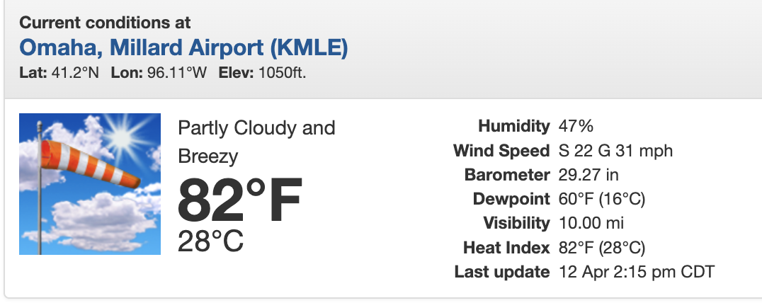
Dewpoints have pushed into the low 60s now in Omaha with the dryline to our west. This dewpoint may fluctuate back down some as there is a column of higher dewpoints directly behind the warm front (which we are in now) but even upper 50s should be enough for severe weather/potential tornadoes.
-
stormchaser
- Planning Board
- Posts: 2380
- Joined: Fri Jun 01, 2018 1:14 pm
Re: 2022 Weather Thread
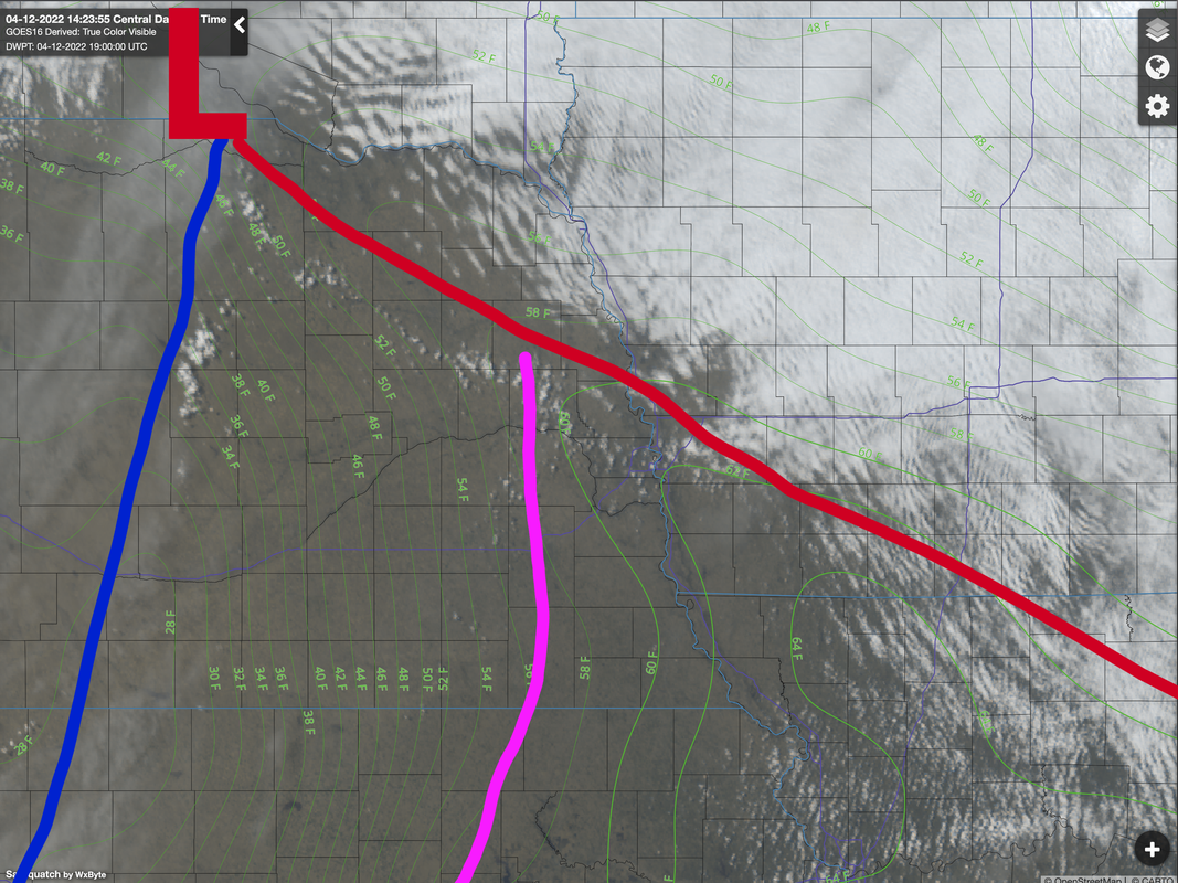
Pretty easy to see where the warm front and dryline are now (roughly). Starting to see some agitated cumulus forming. Storm development to our north will occur earlier than it will down here in Omaha (our area will mostly be after 7 still). Tornado potential is highest along the warm front and near the low....
Warm front: in red
Cold front: in blue
Dryline: in Pink
Warm front: in red
Cold front: in blue
Dryline: in Pink
-
skinzfan23
- City Council
- Posts: 11671
- Joined: Mon Feb 09, 2004 5:26 pm
- Location: Omaha/Bellevue
Re: 2022 Weather Thread
At my house in Bellevue, we went from 59 at 1 pm to 84 at 2:45 pm, that is crazy.
-
stormchaser
- Planning Board
- Posts: 2380
- Joined: Fri Jun 01, 2018 1:14 pm
Re: 2022 Weather Thread
Tornado watch will likely be issued shortly for areas just north of Omaha (possibly including Omaha too).
More info:
https://www.spc.noaa.gov/products/md/md0457.html
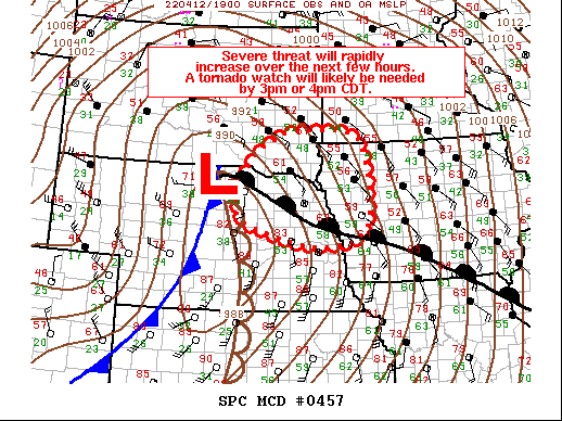
More info:
https://www.spc.noaa.gov/products/md/md0457.html
-
Brad
- Photographer
- Posts: 1036702
- Joined: Sun Feb 29, 2004 12:03 am
- Location: Omaha, NE
Re: 2022 Weather Thread
Surprisingly north of Washington County.stormchaser wrote: Tue Apr 12, 2022 8:00 pm Tornado watch will likely be issued shortly for areas just north of Omaha (possibly including Omaha too).
Omaha Skyline Photos, Omaha Aerial Photos, and More.
Website: www.bradwilliamsphotography.com
Facebook: www.facebook.com/bradwilliamsphotography
Twitter: www.twitter.com/bradwphoto
Instagram: www.instagram.com/bradwilliamsphotography
YouTube: www.youtube.com/@bradwilliamsphoto
-
Omaha Cowboy
- The Don
- Posts: 1013737
- Joined: Wed Jan 07, 2004 11:31 am
- Location: West Omaha
Re: 2022 Weather Thread
I just returned home about 15 minutes ago, and flipped the central air conditioning on at my home..skinzfan23 wrote: Tue Apr 12, 2022 7:47 pm At my house in Bellevue, we went from 59 at 1 pm to 84 at 2:45 pm, that is crazy.
I’m sure in about 3 or so hours, I’ll have the heat back on…
Ciao..LiO…Peace
Go Cowboys!
-
Busguy2010
- City Council
- Posts: 7393
- Joined: Sun Apr 10, 2011 12:32 am
- Location: North Central Omaha
Re: 2022 Weather Thread
I turned down the heat in preparation for this. Got down to about 58 in the house last night, but now I have not turned on the AC and the house is surprisingly retaining the coolness pretty good. About 69 in the house now. Not bad.
-
BRoss

- IT Director
- Posts: 10003423
- Joined: Sat Aug 05, 2006 12:39 am
- Location: West Central Omaha
Re: 2022 Weather Thread
Looks like dew point is back down to 50. The temp has hit 90 around here.
-
GetUrban
- Planning Board
- Posts: 2650
- Joined: Sun Nov 23, 2008 9:07 pm
- Location: Omaha
Re: 2022 Weather Thread
Bill Randby took off his jacket. Look out!
He said "They are some big, ugly red brick buildings"
...and then they were gone.
...and then they were gone.