2022 Weather Thread

Grand Island, Hastings, Kearney, Des Moines, and the rest of Nebraska and Iowa
User avatar
stormchaser
Planning Board
Posts: 2380
Joined: Fri Jun 01, 2018 1:14 pm

Re: 2022 Weather Thread

Post by stormchaser »

Busguy2010 wrote: Fri Apr 22, 2022 11:11 pm It definitely was some decent thunder and lightning... But now I sense our rain and storm chances for tomorrow are diminishing. Sounds like our chance for tomorrow evening keeps trending eastward. I'm prepared to end up with next to nothing.
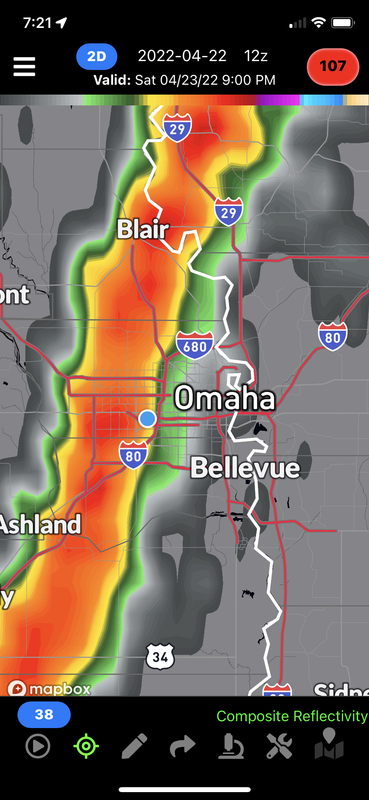
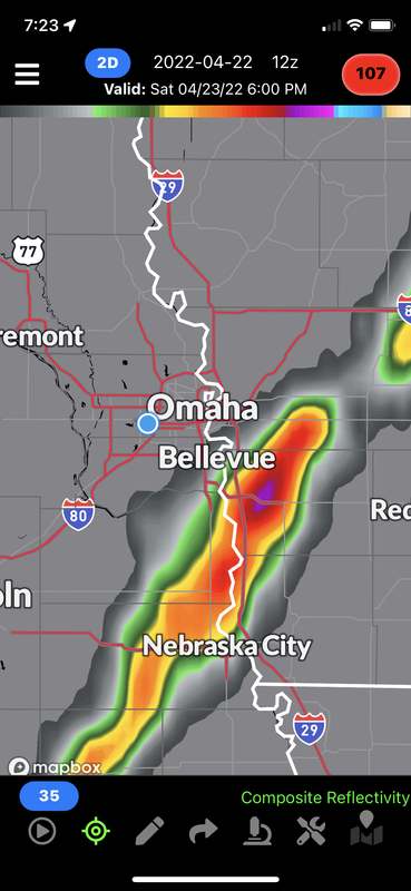
Certainly could end up missing out in Omaha with tonight’s storms dying before they get here and then tomorrow’s stuff possibly developing to our east. Won’t really know until late tonight/tomorrow morning though as ultimately it will depend what happens with exactly when and where the storms die out and how far east the outflow boundary from those storms pushes. If it pushes east too far, Omaha will miss out.

The 12z 3km NAM shows Omaha getting hit:
Image

The 12z HRRR shows storm initiation occurring just east of Omaha:
Image
User avatar
Brad
Photographer
Posts: 1036609
Joined: Sun Feb 29, 2004 12:03 am
Location: Omaha, NE

Re: 2022 Weather Thread

Post by Brad »

Another serious fire situation going on in Western Nebraska tonight.
User avatar
stormchaser
Planning Board
Posts: 2380
Joined: Fri Jun 01, 2018 1:14 pm

Re: 2022 Weather Thread

Post by stormchaser »

Brad wrote: Sat Apr 23, 2022 12:56 am Another serious fire situation going on in Western Nebraska tonight.
Yeah, unfortunately, multiple wildfires. Hope everyone stayed safe...
User avatar
stormchaser
Planning Board
Posts: 2380
Joined: Fri Jun 01, 2018 1:14 pm

Re: 2022 Weather Thread

Post by stormchaser »

Looking less likely Omaha will be hit by severe weather today with storm development likely to happen either right on top of Omaha or just east of town and then reaching severe levels to our east. Timing of storm development will be key if Omaha itself gets hit but odds are more likely that much of the severe weather will miss us.

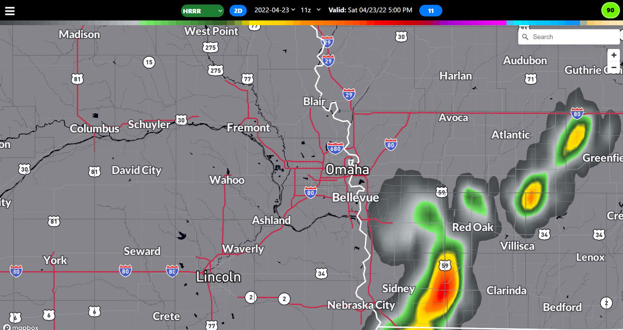
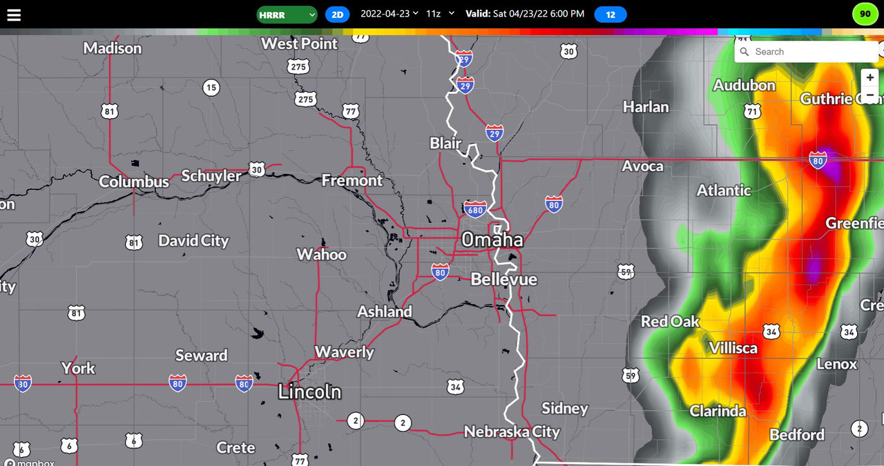
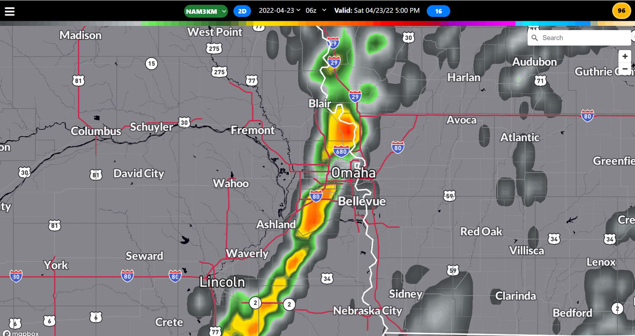
Based on the 11z HRRR, storm initiation should happen sometime around 5 PM near Red Oak, IA, and push east from there. However, the 3km NAM shows it occurring right on top of Omaha. Either way, storm initiation will likely be very close to town so don't be surprised if we go from no storms to severe storms close by over a relatively short period of time late this afternoon.

Simulated radar for 5 PM based on the 11z HRRR:
Image

Simulated radar for 6 PM based on the 11z HRRR:
Image

------

Simulated radar for 5 PM based on the 06z 3km NAM showing storm initiation occurring right on top of Omaha:
Image

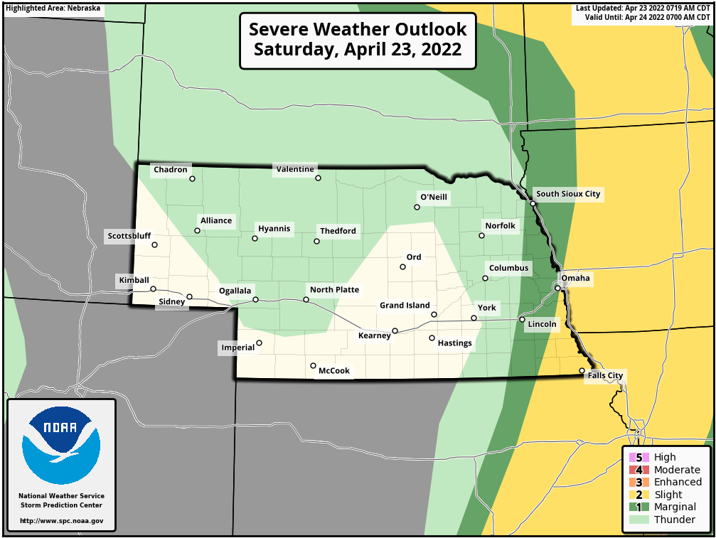
Not surprisingly, the SPC has also shifted the risk area east putting Omaha on the very edge of the slight risk:
Image
User avatar
stormchaser
Planning Board
Posts: 2380
Joined: Fri Jun 01, 2018 1:14 pm

Re: 2022 Weather Thread

Post by stormchaser »

Currently thinking I’ll target Red Oak, IA late this afternoon for potential supercells and at least some tornado threat in that area (though it’s pretty marginal - a tornado or 2 will be possible with any storms that can stay discrete/inflow dominate for long enough).

I’m torn between that target where simulated radar shows supercell development (near Red Oak) and heading northeast into northern IA where visible satellite and mesoanalysis look more favorable (southeast surface winds, etc).

Will have to decide soon 🤔
Last edited by stormchaser on Sat Apr 23, 2022 3:31 pm, edited 1 time in total.
User avatar
damonhynes
Parks & Recreation
Posts: 1280
Joined: Wed Aug 27, 2014 12:35 am
Location: Montgomery County, Texas

Re: 2022 Weather Thread

Post by damonhynes »

I'll be driving to St. Joe for dinner about 4-ish, if I see something, I'll see something! Not expecting to see anything except pretty cauliflower off to my east, but let's just say this is one of those greater-than-zero days.
User avatar
stormchaser
Planning Board
Posts: 2380
Joined: Fri Jun 01, 2018 1:14 pm

Re: 2022 Weather Thread

Post by stormchaser »

damonhynes wrote: Sat Apr 23, 2022 3:29 pm I'll be driving to St. Joe for dinner about 4-ish, if I see something, I'll see something! Not expecting to see anything except pretty cauliflower off to my east, but let's just say this is one of those greater-than-zero days.
Actually St Joe looks like a decent target around that time based on the HRRR anyway…
User avatar
stormchaser
Planning Board
Posts: 2380
Joined: Fri Jun 01, 2018 1:14 pm

Re: 2022 Weather Thread

Post by stormchaser »

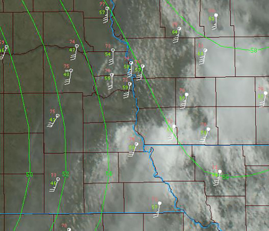
Not hard to figure out/see where the dryline currently is (as of 11:25 AM) based on surface data and visible satellites. This will be the focus of strong/severe storms later this afternoon.

The dryline is currently located on the western edge of Omaha with dewpoints (the green numbers) in the 40s to the west and upper 50s/near 60 to the east (you can even see a little boundary on visible satellite on the western edge of Omaha in the image below). This boundary is moving very slowly to the east but pretty likely it will end up just east of Omaha by the time storms fire in a few hours - unless it completely stalls out and doesn't move much more.

Image
User avatar
stormchaser
Planning Board
Posts: 2380
Joined: Fri Jun 01, 2018 1:14 pm

Re: 2022 Weather Thread

Post by stormchaser »

The dewpoints in Omaha have mostly dropped into the 40s now so any severe weather for the most part should occur east/southeast of here as the dryline has pushed east of our area. Severe storm development will probably be fairly close still in the next couple of hours but Omaha itself will likely be missed...
User avatar
Brad
Photographer
Posts: 1036609
Joined: Sun Feb 29, 2004 12:03 am
Location: Omaha, NE

Re: 2022 Weather Thread

Post by Brad »

Looks like a line of clouds trying to form over the metro and another out to our west.
clouds.PNG
You do not have the required permissions to view the files attached to this post.
User avatar
stormchaser
Planning Board
Posts: 2380
Joined: Fri Jun 01, 2018 1:14 pm

Re: 2022 Weather Thread

Post by stormchaser »

Brad wrote: Sat Apr 23, 2022 7:03 pm Looks like a line of clouds trying to form over the metro and another out to our west.

clouds.PNG
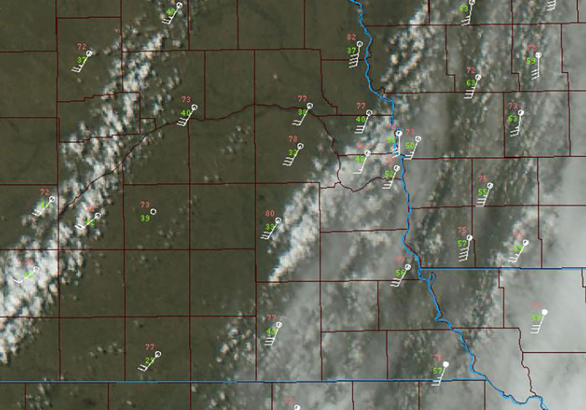
Yep, but with the dewpoints near 50 in far eastern Omaha/Bellevue (and dropping - and all the way down into the 30s to our west), I wouldn't expect anything substantial to fire in Omaha and in the line trying to form to our west.

Just east of Omaha where dewpoints are at least the mid-50s (or higher) is where the severe weather will likely occur. I'd expect storm initiation to start occurring within the next 2 hours in southeast NE and adjacent parts of southwest IA (though again, likely just barely missing Omaha itself).

Image
User avatar
Brad
Photographer
Posts: 1036609
Joined: Sun Feb 29, 2004 12:03 am
Location: Omaha, NE

Re: 2022 Weather Thread

Post by Brad »

Looks like the SPC agrees with you in this MD they just put out.

Image
User avatar
stormchaser
Planning Board
Posts: 2380
Joined: Fri Jun 01, 2018 1:14 pm

Re: 2022 Weather Thread

Post by stormchaser »

Brad wrote: Sat Apr 23, 2022 7:12 pm Looks like the SPC agrees with you in this MD they just put out.

Image
Nice, hadn't seen that yet but based on surface data, I'm not surprised :)
User avatar
stormchaser
Planning Board
Posts: 2380
Joined: Fri Jun 01, 2018 1:14 pm

Re: 2022 Weather Thread

Post by stormchaser »

To clarify though, a few isolated storms will be possible locally late this afternoon and this evening but severe weather is pretty unlikely in Omaha itself (to our east though, it will be interesting).
User avatar
stormchaser
Planning Board
Posts: 2380
Joined: Fri Jun 01, 2018 1:14 pm

Re: 2022 Weather Thread

Post by stormchaser »

Storm initiation is occurring over the eastern side of Omaha currently. The best chance for the storms to go severe warned will be just east of Omaha. The storm near Bellevue in particular could go warned soon.
User avatar
Omaha Cowboy
The Don
Posts: 1013720
Joined: Wed Jan 07, 2004 11:31 am
Location: West Omaha

Re: 2022 Weather Thread

Post by Omaha Cowboy »

I’m holding off giving my car a wash and wax until tomorrow (Sunday)..Although for Omaha proper right now, it looks like it’s going to be a dry evening..I wish this darned wind would start dying down…

Ciao..LiO…Peace
Go Cowboys!
Cermak
Planning Board
Posts: 2334
Joined: Thu Nov 29, 2018 7:02 pm

Re: 2022 Weather Thread

Post by Cermak »

Two really windy days in a row now, a lot of times we will get one windy day but I don’t recall getting two in a row very often. Had some gust at my house today I’m sure we’re 45-50 mph.
User avatar
Busguy2010
City Council
Posts: 7334
Joined: Sun Apr 10, 2011 12:32 am
Location: North Central Omaha

Re: 2022 Weather Thread

Post by Busguy2010 »

Maybe not as bad as today, but tomorrow will be gusty as well. And according to the NWS, there are 20+ MPH gusts throughout the 7 day forecast, aside from e few hours of reprieve scattered throughout. I was wanting to do some grilling or have a fire some time soon, but with the constant winds and dryness, it would be irresponsible. The next couple nights would be perfect if not for the wind.
User avatar
stormchaser
Planning Board
Posts: 2380
Joined: Fri Jun 01, 2018 1:14 pm

Re: 2022 Weather Thread

Post by stormchaser »

Yep, strong winds don't look like they'll calm down anytime soon - at least not for an extended period of time anyway.

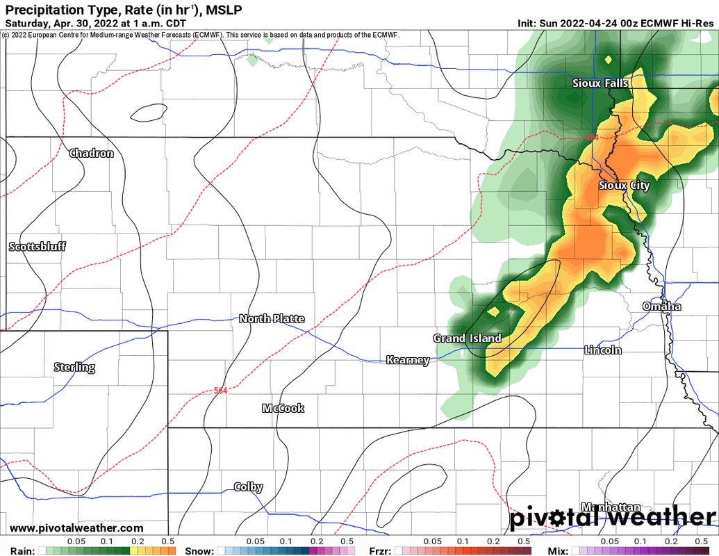
Chance of rain toward the middle of this upcoming week. Then our next chance for severe weather in the area looks like it will be Friday/Friday night (April 29th) with what could potentially be a nighttime damaging wind event in the area. Obviously too far out to know yet but that's how it looks right now anyway based on the 00z ECMWF.

Simulated radar based on the 00z ECMWF for 1 AM Saturday morning showing a line of storms moving southeast into our area:
Image
User avatar
Busguy2010
City Council
Posts: 7334
Joined: Sun Apr 10, 2011 12:32 am
Location: North Central Omaha

Re: 2022 Weather Thread

Post by Busguy2010 »

So, with it getting down to 28 last night, that would presumably be the last freeze... :?: In all the years I've been gardening, I've developed a recording system where it seems the last freeze is usually in the April 14th to 20th range. I always transplant, and direct seed my cool weather crops such as carrots, lettuce, radishes, beets, cool weather herbs, etc after the "last freeze" that occurs within that date range, because they can handle a freeze. I always refer to that freeze as the "speculative last freeze", as it really is usually the last freeze, but between years, there are outliers. This is one of them (4/26)... This should be the last freeze.

Cermak
Planning Board
Posts: 2334
Joined: Thu Nov 29, 2018 7:02 pm

Re: 2022 Weather Thread

Post by Cermak »

Yep, seems like the last one especially with milder weather starting to set in this week.
User avatar
BRoss
IT Director
Posts: 10003397
Joined: Sat Aug 05, 2006 12:39 am
Location: West Central Omaha

Re: 2022 Weather Thread

Post by BRoss »

My weather station only saw it drop to 32. It was above that except for a brief period around 6.
User avatar
Busguy2010
City Council
Posts: 7334
Joined: Sun Apr 10, 2011 12:32 am
Location: North Central Omaha

Re: 2022 Weather Thread

Post by Busguy2010 »

HR Paperstacks wrote: Tue Apr 26, 2022 8:48 pm My weather station only saw it drop to 32. It was above that except for a brief period around 6.
Locations vary, as you know. Eppley reported 28. I live in a lower-lying area, and I believe I also had gotten below 32 at my specific location by far. I had a fire in my greenhouse last night, and I got it up to 90 degrees before falling asleep around 2:30 am. When I woke up to a report of 28, I was a bit surprised. But I didn't doubt it. Usually if I have a good hot fire in my greenhouse, when I let it die, It will end up keeping the greenhouse about 10-15 degrees above the low temp outside. And my greenhouse was 38 for a low, so I could guess at my specific location, it got down to 28-25. Wouldn't doubt it.
User avatar
stormchaser
Planning Board
Posts: 2380
Joined: Fri Jun 01, 2018 1:14 pm

Re: 2022 Weather Thread

Post by stormchaser »

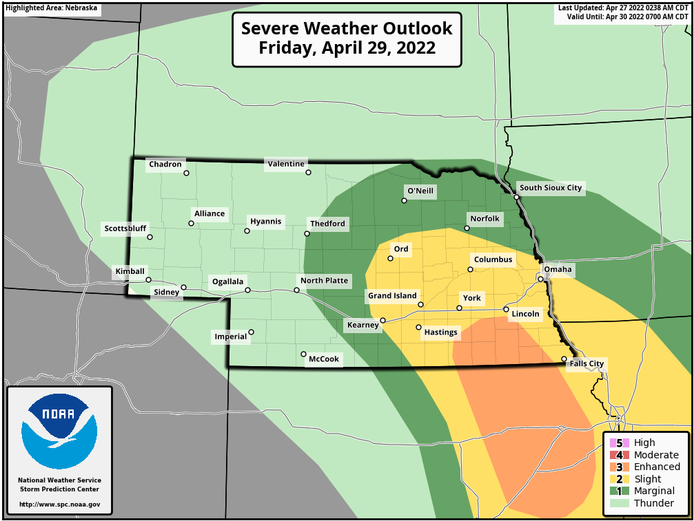
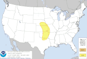
Not surprising but the SPC has a day 4 severe weather outlook for parts of the area for Friday:
Image
User avatar
stormchaser
Planning Board
Posts: 2380
Joined: Fri Jun 01, 2018 1:14 pm

Re: 2022 Weather Thread

Post by stormchaser »

Odds continue to increase for severe weather in parts of the area Friday. The SPC currently has a day 3 slight risk for Omaha itself and an enhanced risk for areas south of Lincoln where a higher tornado threat exists:

Image
ChadJK
Planning Board
Posts: 2515
Joined: Tue Feb 19, 2019 8:51 pm

Re: 2022 Weather Thread

Post by ChadJK »

Here's the current drought conditions for the state:

Image
User avatar
Brad
Photographer
Posts: 1036609
Joined: Sun Feb 29, 2004 12:03 am
Location: Omaha, NE

Re: 2022 Weather Thread

Post by Brad »

stormchaser wrote: Wed Apr 27, 2022 11:27 am Odds continue to increase for severe weather in parts of the area Friday. The SPC currently has a day 3 slight risk for Omaha itself and an enhanced risk for areas south of Lincoln where a higher tornado threat exists:
What's your thoughts on the timing of this weather?
User avatar
damonhynes
Parks & Recreation
Posts: 1280
Joined: Wed Aug 27, 2014 12:35 am
Location: Montgomery County, Texas

Re: 2022 Weather Thread

Post by damonhynes »

As I've mentioned before, I'm a SPC-chaser--my analytical skills leave a lot to be desired. And this is the SWODY3, still a loooong way out. Right now, if you asked my opinion, I'd want to be along US-77 Marysville-Junk City at 4PM. Given my druthers, I like drylines more than triple-points, and warm fronts get too messy.
User avatar
stormchaser
Planning Board
Posts: 2380
Joined: Fri Jun 01, 2018 1:14 pm

Re: 2022 Weather Thread

Post by stormchaser »

Brad wrote: Wed Apr 27, 2022 1:33 pm
stormchaser wrote: Wed Apr 27, 2022 11:27 am Odds continue to increase for severe weather in parts of the area Friday. The SPC currently has a day 3 slight risk for Omaha itself and an enhanced risk for areas south of Lincoln where a higher tornado threat exists:
What's your thoughts on the timing of this weather?
Timing is always difficult to determine reliably when this far out (so don't hold me to it :D and things may quickly change).

Currently, in Omaha itself, it will be during the evening hours here (after 7 PM) and probably more of a damaging wind/hail threat than anything else. It's also very conditional here as the 3km NAM keeps a fair amount of precip north of the warm front for much of the day which would decrease the severe weather threat if that happens (who knows yet though).

Further south near the triple point/dryline, I'd expect storm initiation to occur sometime around 4 PM or 5 PM. However, there is a chance it could be later than that depending on capping - especially along the dry line. But right now, I'd lean on what time peak heating typically happens and expect storm initiation to occur shortly thereafter.
User avatar
stormchaser
Planning Board
Posts: 2380
Joined: Fri Jun 01, 2018 1:14 pm

Re: 2022 Weather Thread

Post by stormchaser »

damonhynes wrote: Wed Apr 27, 2022 2:28 pm As I've mentioned before, I'm a SPC-chaser--my analytical skills leave a lot to be desired. And this is the SWODY3, still a loooong way out. Right now, if you asked my opinion, I'd want to be along US-77 Marysville-Junk City at 4PM. Given my druthers, I like drylines more than triple-points, and warm fronts get too messy.
Depends on the setup. I personally like triple points/warm fronts equally as much as dry lines for a couple of reasons. Along the warm front, you typically get the strongest southeasterly winds which add to the helicity causing storms to spin even more. If a storm embeds on the warm front, odds of it becoming tornadic often go way up - especially one that is on or close to the triple point. As you said, they can sometimes become messy though but if there is enough capping, it probably won't be too bad (assuming the forcing isn't crazy anyway).

With drylines, the storms are often more discrete but you are also often rolling the dice as far as capping goes and how far south storms will be able to develop before the capping is simply too strong. If you play your cards right, though, the storms/tornadoes can be extremely photogenic.
Last edited by stormchaser on Wed Apr 27, 2022 9:05 pm, edited 1 time in total.
User avatar
stormchaser
Planning Board
Posts: 2380
Joined: Fri Jun 01, 2018 1:14 pm

Re: 2022 Weather Thread

Post by stormchaser »

Right now, my "way too early" target would be near Hebron or Chester, NE (along the KS/NE border) or adjacent parts of northern KS for potential tornadic storms sometime around 5 PM...
User avatar
Brad
Photographer
Posts: 1036609
Joined: Sun Feb 29, 2004 12:03 am
Location: Omaha, NE

Re: 2022 Weather Thread

Post by Brad »

Interesting little storm hanging out to our north west for a few hours now.
Louie
County Board
Posts: 4939
Joined: Fri Dec 23, 2011 10:23 pm
Location: Dundee

Re: 2022 Weather Thread

Post by Louie »

Looks like well get at least something tonight.
User avatar
Brad
Photographer
Posts: 1036609
Joined: Sun Feb 29, 2004 12:03 am
Location: Omaha, NE

Re: 2022 Weather Thread

Post by Brad »

Louie wrote: Thu Apr 28, 2022 3:53 am Looks like well get at least something tonight.
May be part of Omaha...
User avatar
Busguy2010
City Council
Posts: 7334
Joined: Sun Apr 10, 2011 12:32 am
Location: North Central Omaha

Re: 2022 Weather Thread

Post by Busguy2010 »

That storm last night was delightful! Looks like only the north central and northwest part of Omaha got it, maybe down to Pacific-ish, but it was great! Lots of lightning, thunder, and rain. I think even a little bit of tiny hail. I wouldn't be surprised if I got around an inch out of it, but Eppley recorded nothing.
Louie
County Board
Posts: 4939
Joined: Fri Dec 23, 2011 10:23 pm
Location: Dundee

Re: 2022 Weather Thread

Post by Louie »

Busguy2010 wrote: Thu Apr 28, 2022 1:23 pm That storm last night was delightful! Looks like only the north central and northwest part of Omaha got it, maybe down to Pacific-ish, but it was great! Lots of lightning, thunder, and rain. I think even a little bit of tiny hail. I wouldn't be surprised if I got around an inch out of it, but Eppley recorded nothing.
Dundee got heavy rain for a solid 20 odd minutes.
User avatar
Brad
Photographer
Posts: 1036609
Joined: Sun Feb 29, 2004 12:03 am
Location: Omaha, NE

Re: 2022 Weather Thread

Post by Brad »

I live near 90th and Center and we got the lightning and thunder, but never even got a sprinkle.
Cermak
Planning Board
Posts: 2334
Joined: Thu Nov 29, 2018 7:02 pm

Re: 2022 Weather Thread

Post by Cermak »

No rain at all last night 114th & Center rd area.
User avatar
Busguy2010
City Council
Posts: 7334
Joined: Sun Apr 10, 2011 12:32 am
Location: North Central Omaha

Re: 2022 Weather Thread

Post by Busguy2010 »

Sorry the whole metro didn't get it. For those who did, it was a great storm. Much needed heavy rain. It's a shame it won't be recorded, because I'm certain it was at least a half inch, and I wouldn't be surprised if it was much closer to a full inch. I didn't have my rain gauge set out, so I'll never know for sure. I wonder what the eastern cutoff was, as according to Louie, Dundee got the rain, but the Airport didnt. Based on the lightning map data, the storm really fizzled out as it moved east. There was no CG lightning recorded east of 72nd, but there definitely was still lightning flashing across the sky and the thunder from those CG strikes that happened just to the west were all still very loud. Based off that map, in Omaha proper, the area right around Westroads and to the north and northwest got the best of it. Really nice power packed little storm. It caught me off gaurd.
User avatar
stormchaser
Planning Board
Posts: 2380
Joined: Fri Jun 01, 2018 1:14 pm

Re: 2022 Weather Thread

Post by stormchaser »

Maybe more heavy rain in the Omaha area tonight too based on the 12z HRRR (including a few severe warned storms mostly for hail). Then another round of potential severe weather tomorrow evening.

Simulated radar loop based on the 12z HRRR for tonight into tomorrow night (times are at the top):
Image