2022 Weather Thread
-
Louie
- County Board
- Posts: 4968
- Joined: Fri Dec 23, 2011 10:23 pm
- Location: Dundee
Re: 2022 Weather Thread
Holy |expletive|, if it plays out like that we'll get well over an inch.
-
stormchaser
- Planning Board
- Posts: 2380
- Joined: Fri Jun 01, 2018 1:14 pm
Re: 2022 Weather Thread
Unfortunately, I'm not very confident it will play out like this. The animated loop is from the 12z HRRR which is usually pretty reliable. However, every subsequent model run (which updates hourly), hasn't shown much of any storm activity developing in our area making me think the 12z run was "out to lunch" as they say, and not reliable. Who knows though, only time will tell.Louie wrote: Thu Apr 28, 2022 5:48 pm Holy |expletive|, if it plays out like that we'll get well over an inch.
-
stormchaser
- Planning Board
- Posts: 2380
- Joined: Fri Jun 01, 2018 1:14 pm
Re: 2022 Weather Thread
So the most likely scenario for today/tonight:
Storms will develop along a boundary from northwest of Norfolk down toward Kearney and south/southwest from there toward the NE/KS border (very easy to see on the visible satellite I included below) and move southeasterly. Some of these storms will be strong/severe with large hail, damaging wind, and a low-end tornado threat.
Visible satellite loop as of ~3:15 PM:
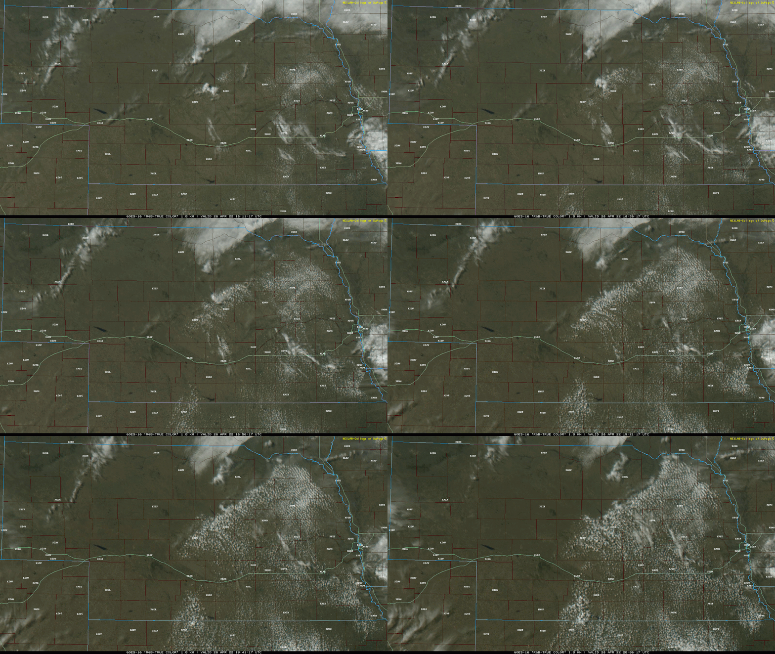
The storms that develop near/northwest of Norfolk will probably slowly make their way southeast towards the Omaha area tonight (possibly near or after midnight). If they maintain their strength, they could impact Omaha with heavy rain and a low-end severe weather threat but that is most likely northwest of Omaha. Isolated large hail would be the primary threat in Omaha itself.
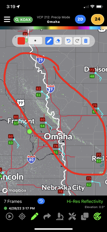
There is currently a warm front in eastern NE/western IA that you can easily see on current radar that goes through just barely northeast of Omaha currently (image included below).
This warm front is the boundary the storms will likely ride along as they move southeast into our area. Anything that can embed on this boundary stands a better chance of rotating which will increase the chances of large hail and possibly a brief tornado (those odds are higher northwest of Omaha currently somewhere closer to Norfolk probably). That said, dewpoints are pretty marginal so storms will probably be fairly elevated, which will decrease any tornado risk in our area (but never say never though odds are very low).
Radar as of ~3:15 PM showing the warm front on the northeast side of Omaha:
Storms will develop along a boundary from northwest of Norfolk down toward Kearney and south/southwest from there toward the NE/KS border (very easy to see on the visible satellite I included below) and move southeasterly. Some of these storms will be strong/severe with large hail, damaging wind, and a low-end tornado threat.
Visible satellite loop as of ~3:15 PM:
The storms that develop near/northwest of Norfolk will probably slowly make their way southeast towards the Omaha area tonight (possibly near or after midnight). If they maintain their strength, they could impact Omaha with heavy rain and a low-end severe weather threat but that is most likely northwest of Omaha. Isolated large hail would be the primary threat in Omaha itself.
There is currently a warm front in eastern NE/western IA that you can easily see on current radar that goes through just barely northeast of Omaha currently (image included below).
This warm front is the boundary the storms will likely ride along as they move southeast into our area. Anything that can embed on this boundary stands a better chance of rotating which will increase the chances of large hail and possibly a brief tornado (those odds are higher northwest of Omaha currently somewhere closer to Norfolk probably). That said, dewpoints are pretty marginal so storms will probably be fairly elevated, which will decrease any tornado risk in our area (but never say never though odds are very low).
Radar as of ~3:15 PM showing the warm front on the northeast side of Omaha:
-
stormchaser
- Planning Board
- Posts: 2380
- Joined: Fri Jun 01, 2018 1:14 pm
Re: 2022 Weather Thread
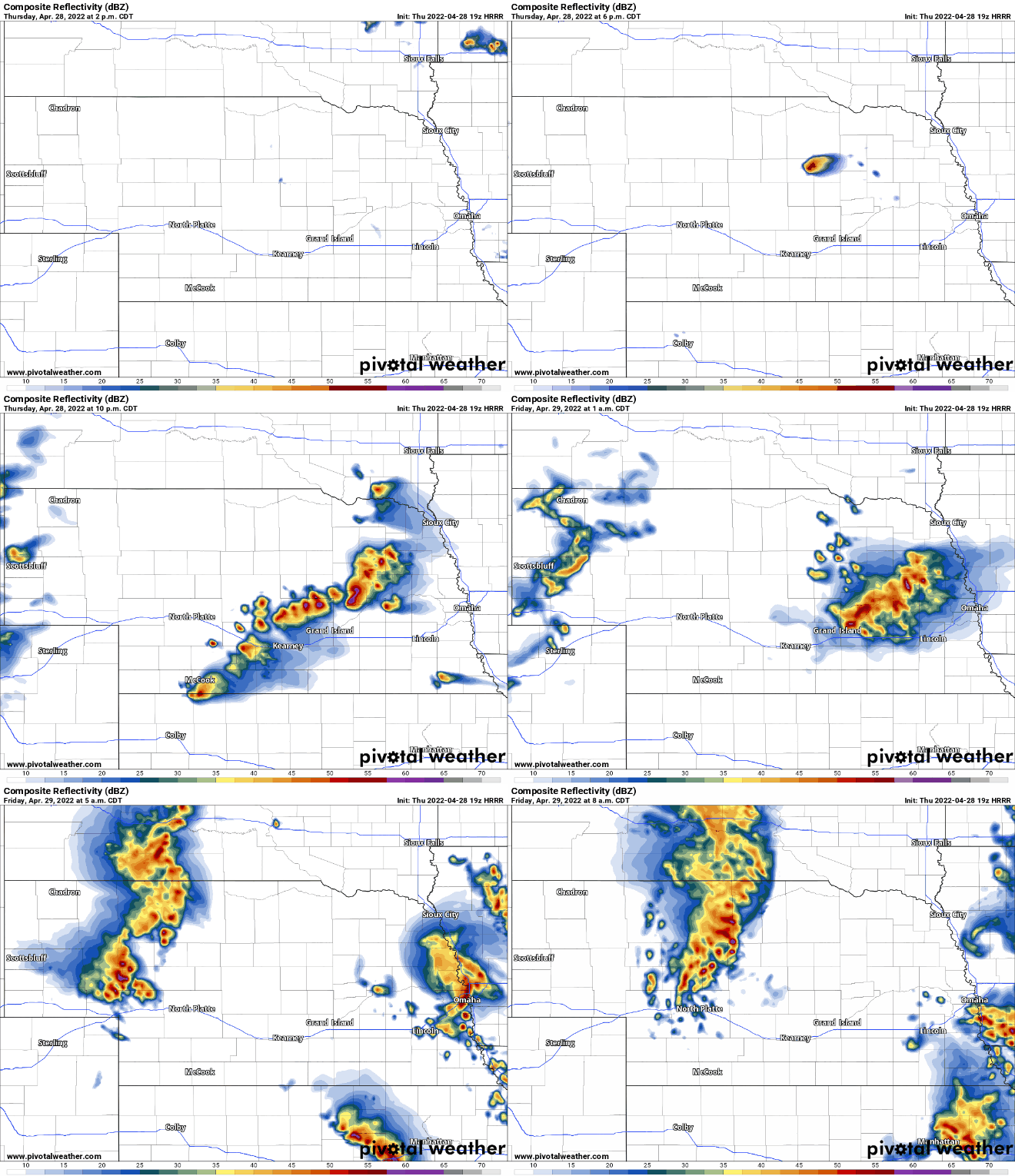
Here is the latest 19z HRRR simulated radar. What this shows is probably pretty accurate in how things play out this evening/tonight with storms in our area after dark (probably midnight or later):
-
stormchaser
- Planning Board
- Posts: 2380
- Joined: Fri Jun 01, 2018 1:14 pm
Re: 2022 Weather Thread
Also, as many of you know, severe weather is expected in the area tomorrow. The latest runs of the HRRR in particular are showing a dangerous day across much of the eastern half of Nebraska (including Lincoln/Omaha).
I'll post an update this evening showing more specific info but just an early heads up that things are trending toward Lincoln/Omaha being more at risk than before...
I'll post an update this evening showing more specific info but just an early heads up that things are trending toward Lincoln/Omaha being more at risk than before...
-
Busguy2010

- City Council
- Posts: 7393
- Joined: Sun Apr 10, 2011 12:32 am
- Location: North Central Omaha
Re: 2022 Weather Thread
Hmm, on the noon newscast, KETV indicated the storms would be around Omaha by 10pm, and the current radar shows them a bit closer at this hour than the model depicted. Also the NWS has us at a 40% chance, and KETV's model looked pretty spotty. I at least hope they come through and are out sooner than that. Maybe about out by 11:15 or not starting til 11:30 would a good time. 11:15 is shower time. I hate when I have to work around the storms to take a shower.
-
Busguy2010
- City Council
- Posts: 7393
- Joined: Sun Apr 10, 2011 12:32 am
- Location: North Central Omaha
Re: 2022 Weather Thread
Although, they do look like they're barely moving... On the one that's up by Norfolk right now, its got some pretty high tops... Gotta be some big hail in that one.
Last edited by Busguy2010 on Thu Apr 28, 2022 11:36 pm, edited 1 time in total.
-
stormchaser
- Planning Board
- Posts: 2380
- Joined: Fri Jun 01, 2018 1:14 pm
Re: 2022 Weather Thread
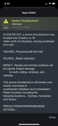
The problem is they’re only moving at 5mph so I still feel pretty confident it’s going to be closer to midnight before they get here. Who knows though. Depends on how long it takes before they start moving.Busguy2010 wrote: Thu Apr 28, 2022 11:29 pm Hmm, on the noon newscast, KETV indicated the storms would be around Omaha by 10pm, and the current radar shows them a bit closer at this hour than the model depicted. Also the NWS has us at a 40% chance, and KETV's model looked pretty spotty. I at least hope they come through and are out sooner than that. Maybe about out by 11:15 or not starting til 11:30 would a good time. 11:15 is shower time. I hate when I have to work around the storms to take a shower.
Warning text showing how slow they’re moving:
-
Busguy2010
- City Council
- Posts: 7393
- Joined: Sun Apr 10, 2011 12:32 am
- Location: North Central Omaha
Re: 2022 Weather Thread
Yeah, you're not lying about that... They might as well be stationary.
-
stormchaser
- Planning Board
- Posts: 2380
- Joined: Fri Jun 01, 2018 1:14 pm
Re: 2022 Weather Thread
Storms are finally on the move and heading toward the Omaha area as additional storms are firing near Lincoln. Areas west of Omaha should gradually fill in with more and more storms as things push east/southeast into the Omaha area near or after midnight tonight (assuming they maintain their strength) bringing with them some (hopefully) decent rain totals and at least some chance of hail in the area (though most of it should be small in our area if there is any). The heaviest rain totals will likely stay west of Omaha though.
Tomorrow/Friday (April 29th)
A severe weather outbreak is expected tomorrow over a relatively large portion of our area. The SPC currently has the Omaha area in a slight risk, with an "enhanced risk" and greater tornado potential depicted south of Lincoln. Don't be surprised if this higher tornado risk gets shifted north some with the next SPC outlook though.
Based on radar trends pretty much all day today, I currently think the highest tornado risk is closer to I-80 in an area from McCook/Hastings/Grand Island to Lincoln or wherever the southern tip of the line ends up (aka a "tail-end charlie tornado" risk). This is where an outflow boundary is depicted to be from the previous night's storms which will add to the low-level helicity and increase the tornado potential. If any storms remain discrete south of I-80, they will favor tornado potential as well as large hail/damaging wind.
North of I-80, a damaging wind event looks possible with the potential of a widespread/significant damaging wind event in some areas, especially for areas west/northwest of Omaha/north/northwest of lincoln. Some tornado risk exists in this area as well with embedded supercells possible in this line.
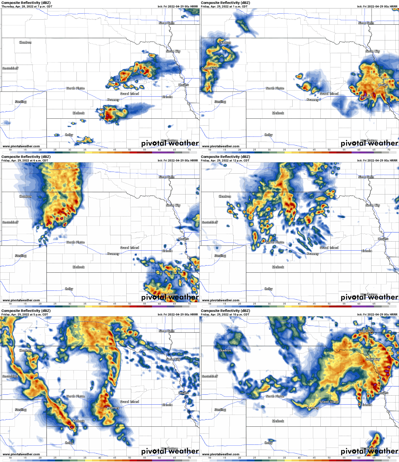
Shown below is a simulated radar loop showing the late-night storms in our area tonight and then the new storms tomorrow including the tornado potential along and south of I-80 west of Lincoln and damaging wind threat/isolated tornado threat north of I-80 near or just north of Omaha.
Of course, this is just one single run of one model. However, this has basically been what the HRRR has shown all day so I have no reason at this point to think it's unrealistic. That doesn't mean things won't change though. Like normal, I will know more in the morning.
Simulated radar based on the 00z HRRR:
Depicted dewpoints based on the 00z HRRR (the blue areas are 60 and above):

Tomorrow/Friday (April 29th)
A severe weather outbreak is expected tomorrow over a relatively large portion of our area. The SPC currently has the Omaha area in a slight risk, with an "enhanced risk" and greater tornado potential depicted south of Lincoln. Don't be surprised if this higher tornado risk gets shifted north some with the next SPC outlook though.
Based on radar trends pretty much all day today, I currently think the highest tornado risk is closer to I-80 in an area from McCook/Hastings/Grand Island to Lincoln or wherever the southern tip of the line ends up (aka a "tail-end charlie tornado" risk). This is where an outflow boundary is depicted to be from the previous night's storms which will add to the low-level helicity and increase the tornado potential. If any storms remain discrete south of I-80, they will favor tornado potential as well as large hail/damaging wind.
North of I-80, a damaging wind event looks possible with the potential of a widespread/significant damaging wind event in some areas, especially for areas west/northwest of Omaha/north/northwest of lincoln. Some tornado risk exists in this area as well with embedded supercells possible in this line.
Shown below is a simulated radar loop showing the late-night storms in our area tonight and then the new storms tomorrow including the tornado potential along and south of I-80 west of Lincoln and damaging wind threat/isolated tornado threat north of I-80 near or just north of Omaha.
Of course, this is just one single run of one model. However, this has basically been what the HRRR has shown all day so I have no reason at this point to think it's unrealistic. That doesn't mean things won't change though. Like normal, I will know more in the morning.
Simulated radar based on the 00z HRRR:
Depicted dewpoints based on the 00z HRRR (the blue areas are 60 and above):
-
Busguy2010
- City Council
- Posts: 7393
- Joined: Sun Apr 10, 2011 12:32 am
- Location: North Central Omaha
Re: 2022 Weather Thread
Pretty well looking like all we will end up with in Omaha is a semi-decent rain. But then again, it does slightly look like its threatening to fizzle out too.
-
stormchaser
- Planning Board
- Posts: 2380
- Joined: Fri Jun 01, 2018 1:14 pm
Re: 2022 Weather Thread
Yeah, not expecting any severe weather tonight in our area. Just rain/thunder maybe isolated small hail…Busguy2010 wrote: Fri Apr 29, 2022 4:14 am Pretty well looking like all we will end up with in Omaha is a semi-decent rain. But then again, it does slightly look like its threatening to fizzle out too.
-
stormchaser
- Planning Board
- Posts: 2380
- Joined: Fri Jun 01, 2018 1:14 pm
Re: 2022 Weather Thread
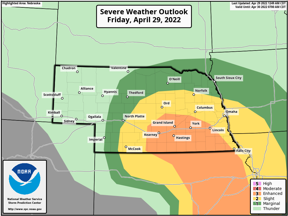
The SPC has shifted the "enhanced risk" and higher tornado risk north (which I mentioned would probably happen last night). Omaha itself still looks like the primary risk is large hail and damaging wind this evening.
It's worth noting, that it won't feel at all like a severe weather day in Omaha itself (temps in the low 60s for much of the day). However, a warm front will be pushing at least close to our area bringing with it higher temps/dewpoints along and to the south of it (though things still probably won't warm much locally in Omaha, dewpoints will go up, however). Long story short, don't be fooled - there 100% is still a risk of severe weather in the Omaha area and a pretty decently high tornado risk to our west/southwest.
My initial target right now is probably somewhere between York/Hastings and the KS border for tornado potential late this afternoon/early evening (though tornado potential will probably start west of there, I won't probably have time to get that far west).
In areas of southern NE, there is a risk of strong tornadoes (per the latest SPC outlook text and parameters depicted on model guidance). Heads up in areas along and south of I-80 this afternoon/evening. This is particularly true in the Grand Island, Hastings, York areas down toward the KS border.
Latest SPC Outlook:
It's worth noting, that it won't feel at all like a severe weather day in Omaha itself (temps in the low 60s for much of the day). However, a warm front will be pushing at least close to our area bringing with it higher temps/dewpoints along and to the south of it (though things still probably won't warm much locally in Omaha, dewpoints will go up, however). Long story short, don't be fooled - there 100% is still a risk of severe weather in the Omaha area and a pretty decently high tornado risk to our west/southwest.
My initial target right now is probably somewhere between York/Hastings and the KS border for tornado potential late this afternoon/early evening (though tornado potential will probably start west of there, I won't probably have time to get that far west).
In areas of southern NE, there is a risk of strong tornadoes (per the latest SPC outlook text and parameters depicted on model guidance). Heads up in areas along and south of I-80 this afternoon/evening. This is particularly true in the Grand Island, Hastings, York areas down toward the KS border.
Latest SPC Outlook:
-
stormchaser
- Planning Board
- Posts: 2380
- Joined: Fri Jun 01, 2018 1:14 pm
Re: 2022 Weather Thread
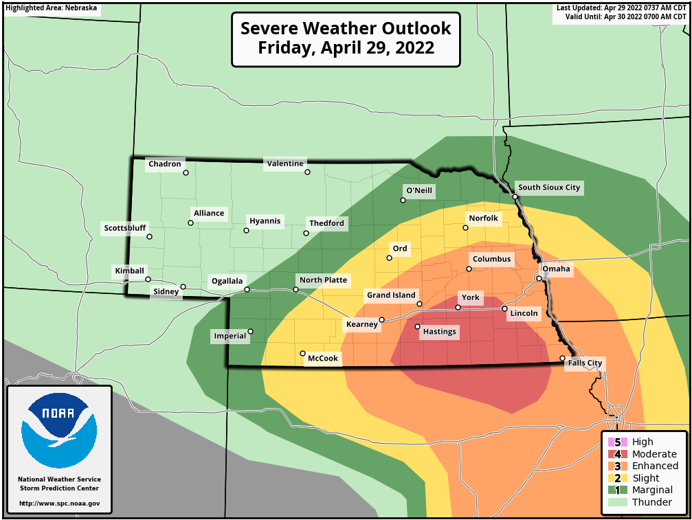
SPC just updated and put out a "moderate risk" in the area I outlined in my text above that has a higher chance for strong tornadoes and/or a damaging wind event. As I said, this is increasingly looking like a dangerous day in many areas - in particular in and near the moderate risk area.
Omaha itself has also been bumped up to an enhanced risk - mostly for damaging wind/hail this evening though there is some tornado threat here as well.
Omaha itself has also been bumped up to an enhanced risk - mostly for damaging wind/hail this evening though there is some tornado threat here as well.
-
Louie
- County Board
- Posts: 4968
- Joined: Fri Dec 23, 2011 10:23 pm
- Location: Dundee
Re: 2022 Weather Thread
What were the rain totals for last night?
-
stormchaser
- Planning Board
- Posts: 2380
- Joined: Fri Jun 01, 2018 1:14 pm
Re: 2022 Weather Thread
I haven't seen any official totals but radar estimates show most areas in and around Omaha itself getting a half-inch of rain or less with heavier amounts west, south, and east of Omaha...
-
Brad

- Photographer
- Posts: 1036702
- Joined: Sun Feb 29, 2004 12:03 am
- Location: Omaha, NE
Re: 2022 Weather Thread
I only had 0.25" near 90th and Center.

Omaha Skyline Photos, Omaha Aerial Photos, and More.
Website: www.bradwilliamsphotography.com
Facebook: www.facebook.com/bradwilliamsphotography
Twitter: www.twitter.com/bradwphoto
Instagram: www.instagram.com/bradwilliamsphotography
YouTube: www.youtube.com/@bradwilliamsphoto
-
stormchaser
- Planning Board
- Posts: 2380
- Joined: Fri Jun 01, 2018 1:14 pm
Re: 2022 Weather Thread
Sounds about right for most areas I would assume in Omaha
-
stormchaser
- Planning Board
- Posts: 2380
- Joined: Fri Jun 01, 2018 1:14 pm
Re: 2022 Weather Thread
11 AM Update:
Based on the latest visible satellite, the low pressure/warm front which will be the focus of severe weather/potential tornadoes later today is currently in far southern NE (southwest of Kearney)/northern KS near the NE/KS border moving east. The warm front itself is currently across far northern KS but moving north and angles up toward the low pressure near the KS/NE border. This feature should continue spreading north and dewpoints will increase into the 60s and low 70s (especially near the KS/NE border) and the low should continue moving east/northeast into far southern NE later today.
An additional east/west outflow boundary (from last night's storms) can be seen from near Nebraska City/Beatrice toward Grand Island and slowly moving north. These features will need to be watched closely later as they will likely be the focus for areas of heightened tornado potential (especially if a storm can embed on the outflow boundary/warm front). Otherwise, a fairly widespread damaging wind event should be expected for many areas later today/tonight.
Things are also clearing off west of Omaha which will help destabilize this area for storms later this afternoon/this evening.
Here is the visible satellite loop as of 11 AM:
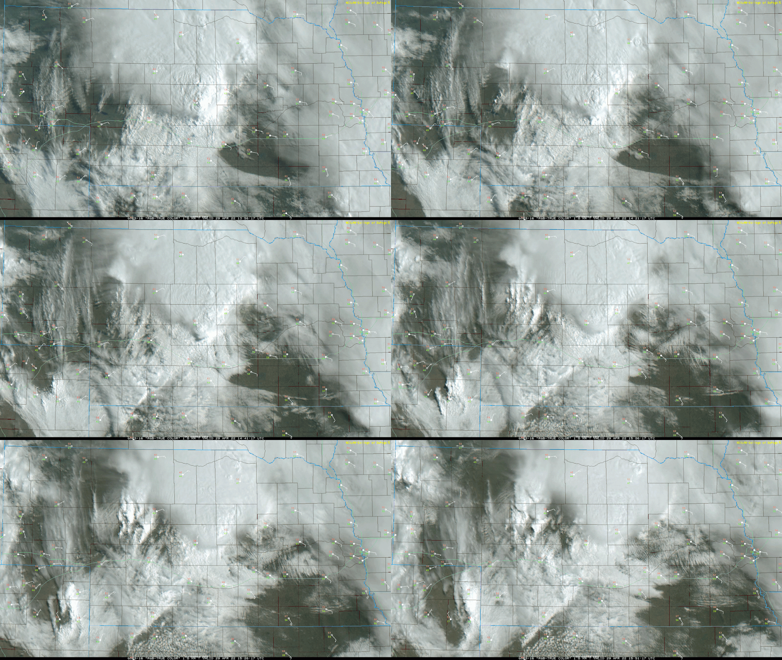
Based on the latest visible satellite, the low pressure/warm front which will be the focus of severe weather/potential tornadoes later today is currently in far southern NE (southwest of Kearney)/northern KS near the NE/KS border moving east. The warm front itself is currently across far northern KS but moving north and angles up toward the low pressure near the KS/NE border. This feature should continue spreading north and dewpoints will increase into the 60s and low 70s (especially near the KS/NE border) and the low should continue moving east/northeast into far southern NE later today.
An additional east/west outflow boundary (from last night's storms) can be seen from near Nebraska City/Beatrice toward Grand Island and slowly moving north. These features will need to be watched closely later as they will likely be the focus for areas of heightened tornado potential (especially if a storm can embed on the outflow boundary/warm front). Otherwise, a fairly widespread damaging wind event should be expected for many areas later today/tonight.
Things are also clearing off west of Omaha which will help destabilize this area for storms later this afternoon/this evening.
Here is the visible satellite loop as of 11 AM:
-
stormchaser
- Planning Board
- Posts: 2380
- Joined: Fri Jun 01, 2018 1:14 pm
Re: 2022 Weather Thread
To clarify, severe weather is unlikely in Omaha itself until after 6 or 7 PM...
-
stormchaser
- Planning Board
- Posts: 2380
- Joined: Fri Jun 01, 2018 1:14 pm
Re: 2022 Weather Thread
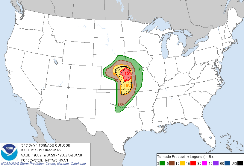
SPC has increased the tornado threat in the Beatrice area and on south into adjacent parts of northern KS (where things have cleared off). Strong tornadoes are possible, especially in this 15% tornado risk area.
-
damonhynes

- Parks & Recreation
- Posts: 1282
- Joined: Wed Aug 27, 2014 12:35 am
- Location: Montgomery County, Texas
Re: 2022 Weather Thread
Aye, it looks like the DL will unzip on its northern end at least. Still liking Marysville, great road options from there.
We discussed the triple-point earlier this week, one issue I have with that is that the storm motions get all loopy, which is to be expected given the fact that the low is right there. We'll see :-)
We discussed the triple-point earlier this week, one issue I have with that is that the storm motions get all loopy, which is to be expected given the fact that the low is right there. We'll see :-)
Last edited by damonhynes on Fri Apr 29, 2022 4:47 pm, edited 1 time in total.
-
stormchaser
- Planning Board
- Posts: 2380
- Joined: Fri Jun 01, 2018 1:14 pm
Re: 2022 Weather Thread
Yeah, I'm leaning toward Marysville also and maybe heading west from there once things start to fire. The only downside is that east/west road west of Marysville always seems to give me cellphone signal issues (I have Verizon) which makes things that much more challenging, especially if storms are fast-moving.damonhynes wrote: Fri Apr 29, 2022 4:45 pm Aye, it looks like the DL will unzip on its northern end at least. Still liking Marysville, great road options from there.
-
Coyote
- City Council
- Posts: 34365
- Joined: Tue Nov 18, 2003 5:18 pm
- Yahoo Messenger: jestcoyote
- Location: Aksarben Village
Re: 2022 Weather Thread
So, it looks like the storm will happen about 10:30 tonight.
-
stormchaser
- Planning Board
- Posts: 2380
- Joined: Fri Jun 01, 2018 1:14 pm
Re: 2022 Weather Thread
Yeah, sometime probably between 9 and midnight anyway in Omaha itself but 10-10:30 is a good guestimate based on the latest model trends. Could change yet though if things speed up...
-
Coyote
- City Council
- Posts: 34365
- Joined: Tue Nov 18, 2003 5:18 pm
- Yahoo Messenger: jestcoyote
- Location: Aksarben Village
Re: 2022 Weather Thread
Strong to severe storms likely tonight
-
Louie
- County Board
- Posts: 4968
- Joined: Fri Dec 23, 2011 10:23 pm
- Location: Dundee
Re: 2022 Weather Thread
Well that seemed very doom and gloom.
-
stormchaser
- Planning Board
- Posts: 2380
- Joined: Fri Jun 01, 2018 1:14 pm
Re: 2022 Weather Thread
Tornado watch was just issued for central NE including the potential for strong tornadoes...
https://www.spc.noaa.gov/products/watch/ww0157.html
https://www.spc.noaa.gov/products/watch/ww0157.html
-
Omaha Cowboy

- The Don
- Posts: 1013737
- Joined: Wed Jan 07, 2004 11:31 am
- Location: West Omaha
Re: 2022 Weather Thread
At 2:15 pm it’s 61 degrees..it’s going to struggle to reach the 69 she is predicting..
If that temp stays in the low 60’s I believe it greatly reduces any tornado threat, along with diminishing the severe storm threat.. If the temp was in the low 70’s right now, I’d be very concerned in the Omaha area..
I’m no meteorologist, but I don’t think I’m too far off..being very much an arm-chair weather watcher…
Ciao..LiO…Peace
If that temp stays in the low 60’s I believe it greatly reduces any tornado threat, along with diminishing the severe storm threat.. If the temp was in the low 70’s right now, I’d be very concerned in the Omaha area..
I’m no meteorologist, but I don’t think I’m too far off..being very much an arm-chair weather watcher…
Ciao..LiO…Peace
Go Cowboys!
-
stormchaser
- Planning Board
- Posts: 2380
- Joined: Fri Jun 01, 2018 1:14 pm
Re: 2022 Weather Thread
I don't rely on TV meteorologists at all (since I do my own forecasting). However, like I said this morning, much of today isn't going to feel like a severe weather day with temps in the low 60s in Omaha itself. Don't be fooled though - I'd be shocked if Omaha doesn't get severe weather this evening (mostly in the form of a damaging wind event).Omaha Cowboy wrote: Fri Apr 29, 2022 7:23 pm At 2:15 pm it’s 61 degrees..it’s going to struggle to reach the 69 she is predicting..
If that temp stays in the low 60’s I believe it greatly reduces any tornado threat, along with diminishing the severe storm threat.. If the temp was in the low 70’s right now, I’d be very concerned in the Omaha area..
I’m no meteorologist, but I don’t think I’m too far off..being very much an arm-chair weather watcher…
Ciao..LiO…Peace
The tornado threat today is going to be west and south of Omaha as expected, especially in areas like Grand Island, Hastings, and over toward Beatrice along and south of the warm front.
Last edited by stormchaser on Fri Apr 29, 2022 7:30 pm, edited 2 times in total.
-
Cermak
- Planning Board
- Posts: 2348
- Joined: Thu Nov 29, 2018 7:02 pm
Re: 2022 Weather Thread
Seems to cool for any severe weather. Unless it starts to suddenly warm up later this afternoon to at least 70 then I might change my outlook. I guess we will have to wait and see what happens. I don’t ever recall severe high winds in Omaha with temps below 70. Severe winds would be at least 70 mph in my opinion.
-
Omaha Cowboy
- The Don
- Posts: 1013737
- Joined: Wed Jan 07, 2004 11:31 am
- Location: West Omaha
Re: 2022 Weather Thread
Keeping my fingers crossed that any severe weather threat for the Omaha area is minimal..stormchaser wrote: Fri Apr 29, 2022 7:27 pmI’'d be shocked if Omaha doesn't get severe weather this evening (mostly in the form of a damaging wind event).Omaha Cowboy wrote: Fri Apr 29, 2022 7:23 pm At 2:15 pm it’s 61 degrees..it’s going to struggle to reach the 69 she is predicting..
If that temp stays in the low 60’s I believe it greatly reduces any tornado threat, along with diminishing the severe storm threat.. If the temp was in the low 70’s right now, I’d be very concerned in the Omaha area..
I’m no meteorologist, but I don’t think I’m too far off..being very much an arm-chair weather watcher…
Ciao..LiO…Peace
Just let it rain…
Ciao..LiO…Peace
Go Cowboys!
-
stormchaser
- Planning Board
- Posts: 2380
- Joined: Fri Jun 01, 2018 1:14 pm
Re: 2022 Weather Thread
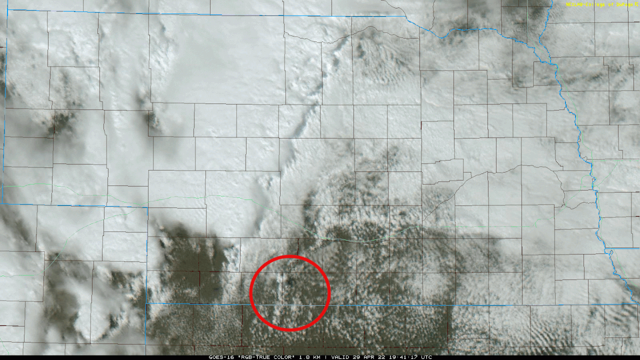
Supercell development is imminent in the red outlined area as cumulus is starting to tower in this area. As these storms track east/northeast, they will likely be tornadic and produce potentially strong/long track tornadoes. Heads up between the red outlined area and east toward the Grand Island/hastings area on south to the KS border over the next few hours...
Last edited by stormchaser on Fri Apr 29, 2022 7:59 pm, edited 2 times in total.
-
stormchaser
- Planning Board
- Posts: 2380
- Joined: Fri Jun 01, 2018 1:14 pm
Re: 2022 Weather Thread
I hear you, always a chance it could die out before getting here but the odds of that happening currently look low. Only time will tell thoughOmaha Cowboy wrote: Fri Apr 29, 2022 7:45 pmKeeping my fingers crossed that any severe weather threat for the Omaha area is minimal..stormchaser wrote: Fri Apr 29, 2022 7:27 pmI’'d be shocked if Omaha doesn't get severe weather this evening (mostly in the form of a damaging wind event).Omaha Cowboy wrote: Fri Apr 29, 2022 7:23 pm At 2:15 pm it’s 61 degrees..it’s going to struggle to reach the 69 she is predicting..
If that temp stays in the low 60’s I believe it greatly reduces any tornado threat, along with diminishing the severe storm threat.. If the temp was in the low 70’s right now, I’d be very concerned in the Omaha area..
I’m no meteorologist, but I don’t think I’m too far off..being very much an arm-chair weather watcher…
Ciao..LiO…Peace
Just let it rain…
Ciao..LiO…Peace

-
Omaha Cowboy
- The Don
- Posts: 1013737
- Joined: Wed Jan 07, 2004 11:31 am
- Location: West Omaha
Re: 2022 Weather Thread
You have become a trusted source. We’re all grateful for your input and updates herestormchaser wrote: Fri Apr 29, 2022 7:52 pmI hear you, always a chance it could die out before getting here but the odds of that happening currently look low. Only time will tell thoughOmaha Cowboy wrote: Fri Apr 29, 2022 7:45 pmKeeping my fingers crossed that any severe weather threat for the Omaha area is minimal..stormchaser wrote: Fri Apr 29, 2022 7:27 pmI’'d be shocked if Omaha doesn't get severe weather this evening (mostly in the form of a damaging wind event).Omaha Cowboy wrote: Fri Apr 29, 2022 7:23 pm At 2:15 pm it’s 61 degrees..it’s going to struggle to reach the 69 she is predicting..
If that temp stays in the low 60’s I believe it greatly reduces any tornado threat, along with diminishing the severe storm threat.. If the temp was in the low 70’s right now, I’d be very concerned in the Omaha area..
I’m no meteorologist, but I don’t think I’m too far off..being very much an arm-chair weather watcher…
Ciao..LiO…Peace
Just let it rain…
Ciao..LiO…Peace
 …
Ciao..LiO…Peace
Go Cowboys!
-
Brad
- Photographer
- Posts: 1036702
- Joined: Sun Feb 29, 2004 12:03 am
- Location: Omaha, NE
Re: 2022 Weather Thread
Tornado Watch, down by Lincoln as expected:
Omaha Skyline Photos, Omaha Aerial Photos, and More.
Website: www.bradwilliamsphotography.com
Facebook: www.facebook.com/bradwilliamsphotography
Twitter: www.twitter.com/bradwphoto
Instagram: www.instagram.com/bradwilliamsphotography
YouTube: www.youtube.com/@bradwilliamsphoto
-
stormchaser
- Planning Board
- Posts: 2380
- Joined: Fri Jun 01, 2018 1:14 pm
Re: 2022 Weather Thread
Thanks, I’m far from perfect (obviously) but appreciate the kind wordsOmaha Cowboy wrote: Fri Apr 29, 2022 8:11 pmYou have become a trusted source. We’re all grateful for your input and updates herestormchaser wrote: Fri Apr 29, 2022 7:52 pmI hear you, always a chance it could die out before getting here but the odds of that happening currently look low. Only time will tell thoughOmaha Cowboy wrote: Fri Apr 29, 2022 7:45 pmKeeping my fingers crossed that any severe weather threat for the Omaha area is minimal..stormchaser wrote: Fri Apr 29, 2022 7:27 pmI’'d be shocked if Omaha doesn't get severe weather this evening (mostly in the form of a damaging wind event).Omaha Cowboy wrote: Fri Apr 29, 2022 7:23 pm At 2:15 pm it’s 61 degrees..it’s going to struggle to reach the 69 she is predicting..
If that temp stays in the low 60’s I believe it greatly reduces any tornado threat, along with diminishing the severe storm threat.. If the temp was in the low 70’s right now, I’d be very concerned in the Omaha area..
I’m no meteorologist, but I don’t think I’m too far off..being very much an arm-chair weather watcher…
Ciao..LiO…Peace
Just let it rain…
Ciao..LiO…Peace
Ciao..LiO…Peace
-
Busguy2010
- City Council
- Posts: 7393
- Joined: Sun Apr 10, 2011 12:32 am
- Location: North Central Omaha
Re: 2022 Weather Thread
MAN the radar is looking UGLY out west. If this holds together for Omaha, buckle up.
-
Coyote
- City Council
- Posts: 34365
- Joined: Tue Nov 18, 2003 5:18 pm
- Yahoo Messenger: jestcoyote
- Location: Aksarben Village
Re: 2022 Weather Thread
Tracking severe storms tonight
-
stormchaser
- Planning Board
- Posts: 2380
- Joined: Fri Jun 01, 2018 1:14 pm
Re: 2022 Weather Thread
Multiple tornado warnings west of Lincoln/Columbus. Things are starting to transition into a damaging wind event as things push east. Going to be a rough few hours….including in Omaha