2022 Weather Thread
-
damonhynes

- Parks & Recreation
- Posts: 1282
- Joined: Wed Aug 27, 2014 12:35 am
- Location: Montgomery County, Texas
-
stormchaser
- Planning Board
- Posts: 2380
- Joined: Fri Jun 01, 2018 1:14 pm
Re: 2022 Weather Thread
Thanks!Brad wrote: Fri May 13, 2022 1:01 pmYou called that! Nice work!stormchaser wrote: Thu May 12, 2022 5:52 pm I’m not sure the severe weather will actually make to Omaha before weakening…
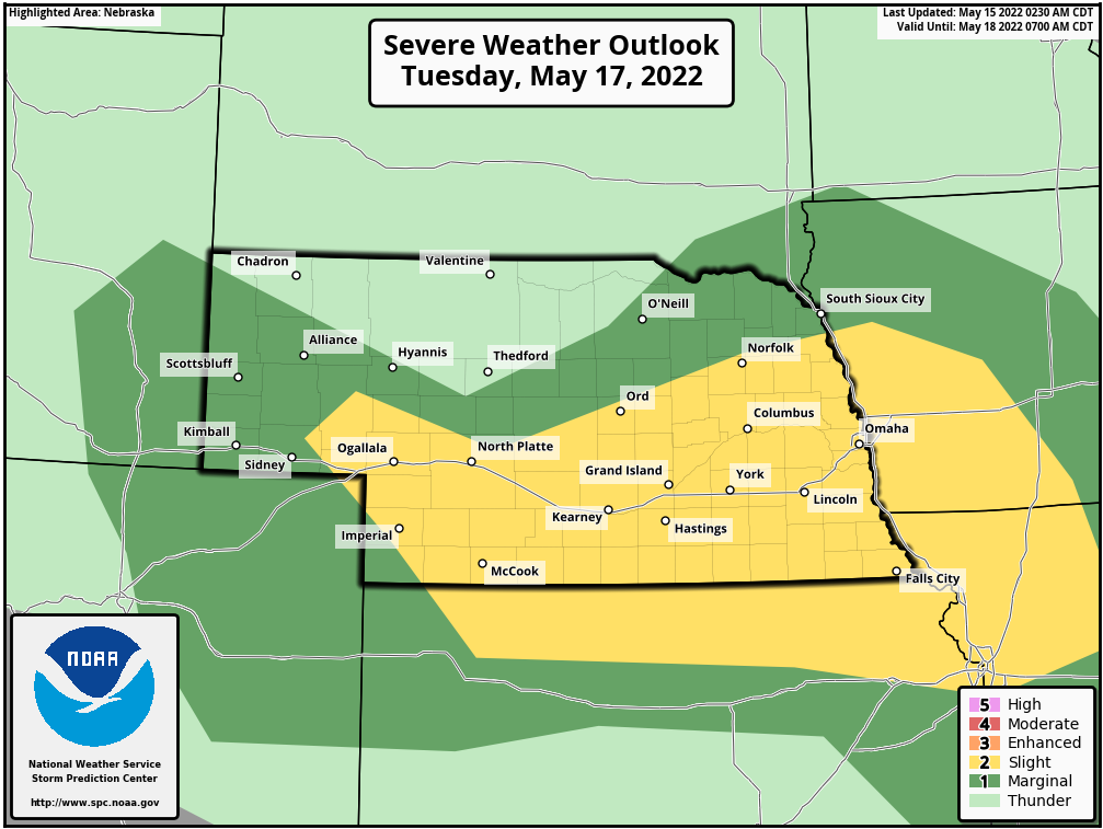
Severe weather again looks possible in our area on Tuesday (May 17th). The SPC has a day 3 outlook for our area - mainly for the risk of damaging wind/hail.
-
ShawJ
- Parks & Recreation
- Posts: 1573
- Joined: Wed Jan 31, 2007 11:58 pm
Re: 2022 Weather Thread
Kind of frustrating to see the rain north and south of the area the past two days and to miss out on most of it.
-
Coyote
- City Council
- Posts: 34365
- Joined: Tue Nov 18, 2003 5:18 pm
- Yahoo Messenger: jestcoyote
- Location: Aksarben Village
Re: 2022 Weather Thread
Omaha 7-day forecast May 16-22
Check out the forecast for the next seven days in the Omaha area.
Check out the forecast for the next seven days in the Omaha area.
-
Brad

- Photographer
- Posts: 1036693
- Joined: Sun Feb 29, 2004 12:03 am
- Location: Omaha, NE
Re: 2022 Weather Thread
You're welcome.stormchaser wrote: Sun May 15, 2022 1:07 pmThanks!Brad wrote: Fri May 13, 2022 1:01 pmYou called that! Nice work!stormchaser wrote: Thu May 12, 2022 5:52 pm I’m not sure the severe weather will actually make to Omaha before weakening…
Severe weather again looks possible in our area on Tuesday (May 17th). The SPC has a day 3 outlook for our area - mainly for the risk of damaging wind/hail.
I haven't had any time to dig in to the forecast yet. This will be yet another night time event, correct?

Omaha Skyline Photos, Omaha Aerial Photos, and More.
Website: www.bradwilliamsphotography.com
Facebook: www.facebook.com/bradwilliamsphotography
Twitter: www.twitter.com/bradwphoto
Instagram: www.instagram.com/bradwilliamsphotography
YouTube: www.youtube.com/@bradwilliamsphoto
-
stormchaser
- Planning Board
- Posts: 2380
- Joined: Fri Jun 01, 2018 1:14 pm
Re: 2022 Weather Thread
Right now it's looking like multiple rounds of potential strong/severe storms during the day/night. The first round is expected earlier in the day and is primarily a marginally severe hail threat. The additional round(s) should develop late in the afternoon and early evening and will be more of a hail/wind threat. Some strong/severe storms may last into the overnight hours as things push off to the southeast.Brad wrote: Mon May 16, 2022 1:03 pm I haven't had any time to dig in to the forecast yet. This will be yet another night time event, correct?
Odds aren't exceedingly high that Omaha specifically will be hit as a result of the primary storm mode is expected to be multicell clusters (possibly supercellular at first and then transitioning to multicell clusters) and for the most part, widely scattered in nature - so most places won't get much of anything.
If the latest 3km NAM verifies, early-day convection/precip may inhibit destabilization in eastern NE (including Omaha) which would further reduce the severe weather threat in the local area with odds appearing to be higher west of here toward the Grand Island/Hastings area. Obviously, it's almost impossible to know "yet" if that will actually happen though so don't let down your guard or anything if you see this - just my initial thoughts aren't very confident we will see much of anything locally but that could quickly change.
-
stormchaser
- Planning Board
- Posts: 2380
- Joined: Fri Jun 01, 2018 1:14 pm
Re: 2022 Weather Thread
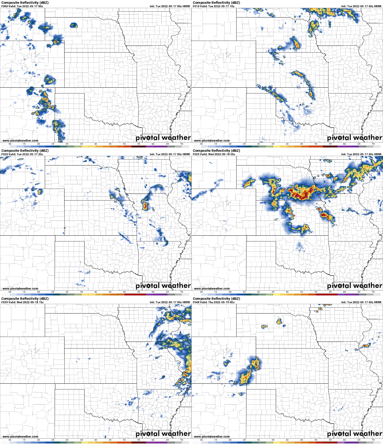
00z HRRR is in and shows the precip moving through our area late tonight/early tomorrow. Then redevelopment occurs during the late afternoon in northeast NE and moves south along a boundary created by earlier convection. How quickly early day precip moves through our area and where the resulting boundary sets up will be key if Omaha is impacted by storms.
It’s worth noting, this model shows more widespread convection which would obviously increase the potential for severe weather in Omaha. Either way, it will probably be close but might end up just west of here (impossible to know yet)…
It’s worth noting, this model shows more widespread convection which would obviously increase the potential for severe weather in Omaha. Either way, it will probably be close but might end up just west of here (impossible to know yet)…
-
stormchaser
- Planning Board
- Posts: 2380
- Joined: Fri Jun 01, 2018 1:14 pm
Re: 2022 Weather Thread
Additional severe weather is possible in parts of the area on Thursday as well…
-
stormchaser
- Planning Board
- Posts: 2380
- Joined: Fri Jun 01, 2018 1:14 pm
Re: 2022 Weather Thread
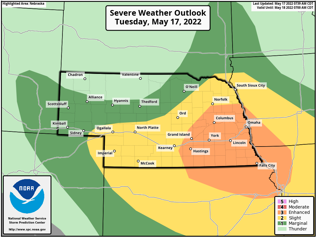
With the lack of morning convection in most areas this morning (aside from in northeast NE), odds for strong/severe storms have increased in much of our area. Consequently, the SPC has upgraded the Omaha/Lincoln area to an "enhanced risk" for severe weather including the risk of large/very large hail, damaging wind, and tornadoes.
-
Omaha Cowboy

- The Don
- Posts: 1013731
- Joined: Wed Jan 07, 2004 11:31 am
- Location: West Omaha
Re: 2022 Weather Thread
Sean Everson, meteorologist on KETV, said this morning the severe risk in the Omaha area would be any time after 7pm. Low tornado threat for Omaha, but possible wind gusts to 60-70mph and hail..
As always, let’s just hope for some rain…
Ciao..LiO…Peace
As always, let’s just hope for some rain…
Ciao..LiO…Peace
Go Cowboys!
-
Brad
- Photographer
- Posts: 1036693
- Joined: Sun Feb 29, 2004 12:03 am
- Location: Omaha, NE
Re: 2022 Weather Thread
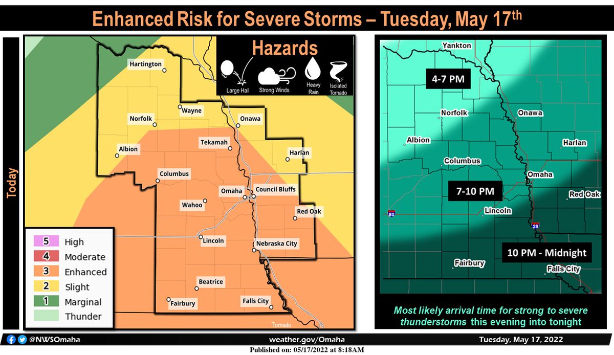
I see the NWS is thinking 7p to 10p. Guessing this stuff to the NW is going to dissipate this morning?stormchaser wrote: Tue May 17, 2022 12:50 pm With the lack of morning convection in most areas this morning (aside from in northeast NE), odds for strong/severe storms have increased in much of our area. Consequently, the SPC has upgraded the Omaha/Lincoln area to an "enhanced risk" for severe weather including the risk of large/very large hail, damaging wind, and tornadoes.
Omaha Skyline Photos, Omaha Aerial Photos, and More.
Website: www.bradwilliamsphotography.com
Facebook: www.facebook.com/bradwilliamsphotography
Twitter: www.twitter.com/bradwphoto
Instagram: www.instagram.com/bradwilliamsphotography
YouTube: www.youtube.com/@bradwilliamsphoto
-
stormchaser
- Planning Board
- Posts: 2380
- Joined: Fri Jun 01, 2018 1:14 pm
Re: 2022 Weather Thread
Yeah, should be mostly after 7 PM. It will be interesting to see what that storm northwest of Omaha ends up doing. I'm assuming it will gradually start dying out in the next couple of hours...
-
damonhynes
- Parks & Recreation
- Posts: 1282
- Joined: Wed Aug 27, 2014 12:35 am
- Location: Montgomery County, Texas
Re: 2022 Weather Thread
Man, it's not even Memorial Day and we're already in that mid-June to August northwest flow. Death ridge, where tornadoes go to die.stormchaser wrote: Tue May 17, 2022 12:50 pm With the lack of morning convection in most areas this morning (aside from in northeast NE), odds for strong/severe storms have increased in much of our area. Consequently, the SPC has upgraded the Omaha/Lincoln area to an "enhanced risk" for severe weather including the risk of large/very large hail, damaging wind, and tornadoes.
-
Brad
- Photographer
- Posts: 1036693
- Joined: Sun Feb 29, 2004 12:03 am
- Location: Omaha, NE
Re: 2022 Weather Thread
I wish I was up in the sandhills last night. Supercells meandering around at only 5mph! Saw a few really nice photos from up there.
Omaha Skyline Photos, Omaha Aerial Photos, and More.
Website: www.bradwilliamsphotography.com
Facebook: www.facebook.com/bradwilliamsphotography
Twitter: www.twitter.com/bradwphoto
Instagram: www.instagram.com/bradwilliamsphotography
YouTube: www.youtube.com/@bradwilliamsphoto
-
stormchaser
- Planning Board
- Posts: 2380
- Joined: Fri Jun 01, 2018 1:14 pm
Re: 2022 Weather Thread
I wouldn't completely rule out the tornado threat. It's unclear if the storms will remain supercellular or grow more upscale into linear or an MCS. If they stay discrete/more supercellular, massive hail and at least some tornado threat will exist. If they grow more upscale, then it will be more of a damaging wind threat (with some larger hail in places).
Here is the simulated radar from the 12z HRRR showing how things are expected to play out on this run of the model anyway (things can quickly change - especially timing):
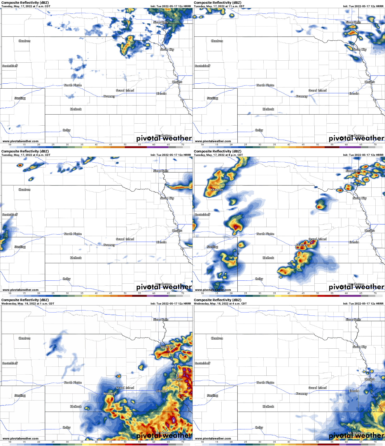
Here is the simulated radar from the 12z HRRR showing how things are expected to play out on this run of the model anyway (things can quickly change - especially timing):
-
stormchaser
- Planning Board
- Posts: 2380
- Joined: Fri Jun 01, 2018 1:14 pm
Re: 2022 Weather Thread
Yep, that would have been pretty amazing...Brad wrote: Tue May 17, 2022 1:49 pm I wish I was up in the sandhills last night. Supercells meandering around at only 5mph! Saw a few really nice photos from up there.
-
stormchaser
- Planning Board
- Posts: 2380
- Joined: Fri Jun 01, 2018 1:14 pm
Re: 2022 Weather Thread
Yep, unfortunately - hopefully it will be temporary though unlike the dead of summer death ridgedamonhynes wrote: Tue May 17, 2022 1:45 pmMan, it's not even Memorial Day and we're already in that mid-June to August northwest flow. Death ridge, where tornadoes go to die.stormchaser wrote: Tue May 17, 2022 12:50 pm With the lack of morning convection in most areas this morning (aside from in northeast NE), odds for strong/severe storms have increased in much of our area. Consequently, the SPC has upgraded the Omaha/Lincoln area to an "enhanced risk" for severe weather including the risk of large/very large hail, damaging wind, and tornadoes.

-
stormchaser
- Planning Board
- Posts: 2380
- Joined: Fri Jun 01, 2018 1:14 pm
Re: 2022 Weather Thread
This is quickly transitioning to more of a heavy rain event than severe weather in our area. That doesn’t mean there won’t be any severe weather but based on the amount of rain developing west of Omaha, I’m having a tough time seeing the environment destabilizing enough in our area…
Further west, odds are higher…
Further west, odds are higher…
-
Busguy2010
- City Council
- Posts: 7380
- Joined: Sun Apr 10, 2011 12:32 am
- Location: North Central Omaha
Re: 2022 Weather Thread
With the surprising efficacy of this afternoon's storm, I have severe (pun intended) doubts we will get the real brunt of the anticipated storms later tonight.
-
stormchaser
- Planning Board
- Posts: 2380
- Joined: Fri Jun 01, 2018 1:14 pm
Re: 2022 Weather Thread
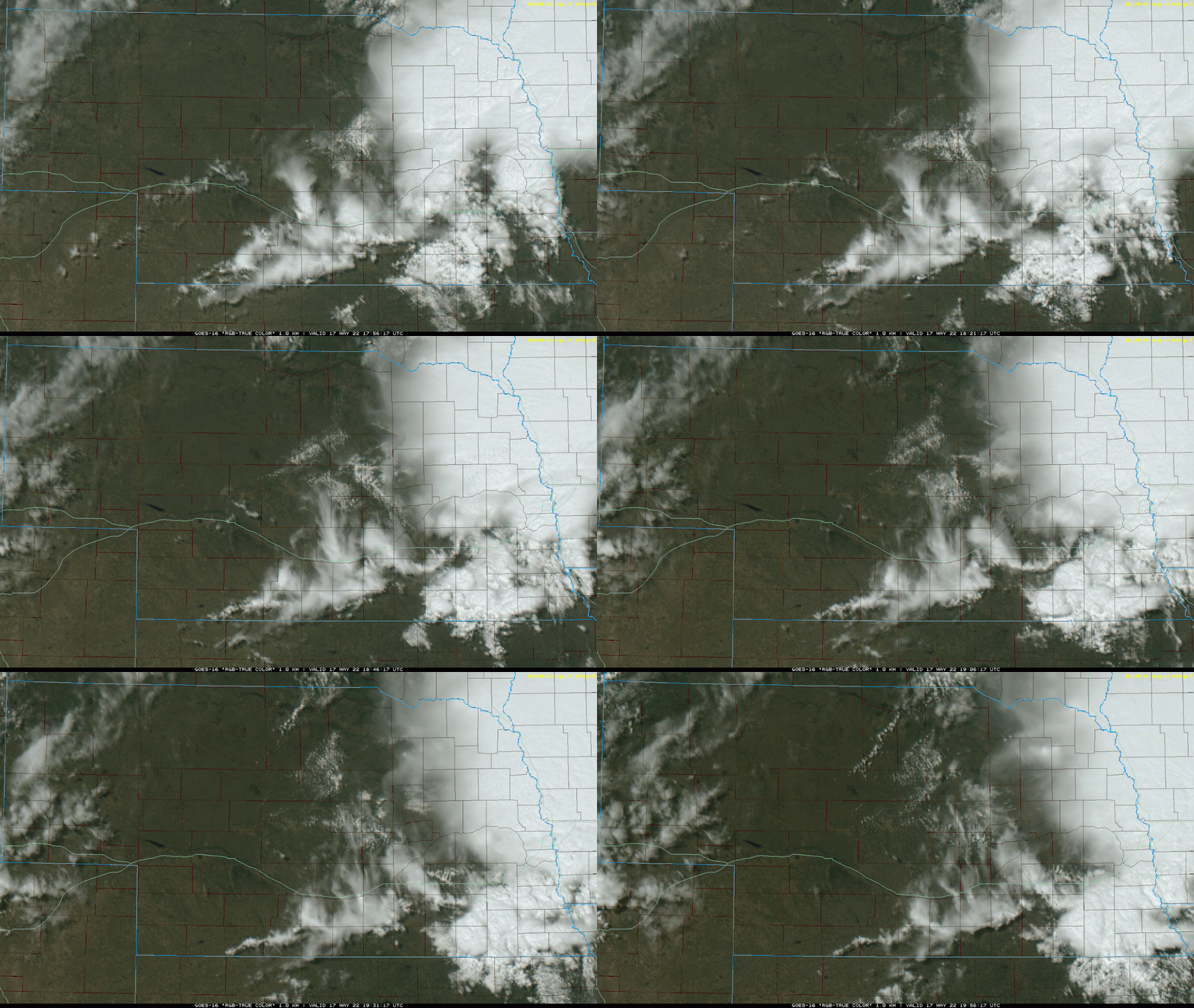
Visible satellite is showing signs of the main round of severe weather starting to develop with 2 notable features. The first is a southeastward moving boundary currently pushing into northern Nebraska with some agitated cumulus forming along and ahead of it.
The second notable feature is an outflow boundary from the current rain/storms in the Omaha area. This outflow boundary can be seen extending from south of Omaha up toward Columbus and northern NE from there where it intersects with the aforementioned southeastward moving boundary. Any storms that can fire along this outflow boundary and can embed on the boundary stand a decent chance of being supercellular and potentially tornadic - especially early on. Even if not tornadic, they will have an increased threat of producing very large hail.
If this outflow boundary south of Omaha currently pushes back north into Omaha (as depicted on the latest HRRR forecast model), Omaha could still be at risk this evening so please do not let down your guard.
Eventually, things should grow upscale into more of a damaging wind threat which "might" extend as far east as Omaha (though odds are way higher IMO to our west).
Visible satellite loop as of 11 AM showing the above-described boundaries:
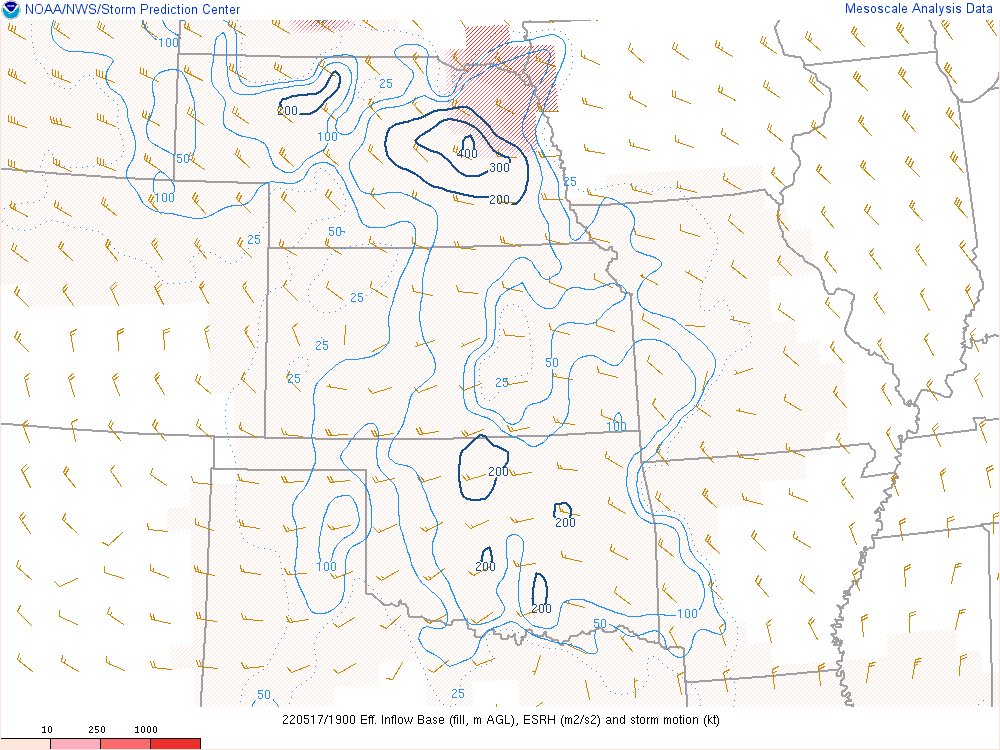
Below is the ESRH based on the latest SPC mesonalyisis as of 3 PM. This shows an area of elevated low-level helicity which is one thing to look for when trying to identify areas favorable for supercell development and potential tornadoes:
The second notable feature is an outflow boundary from the current rain/storms in the Omaha area. This outflow boundary can be seen extending from south of Omaha up toward Columbus and northern NE from there where it intersects with the aforementioned southeastward moving boundary. Any storms that can fire along this outflow boundary and can embed on the boundary stand a decent chance of being supercellular and potentially tornadic - especially early on. Even if not tornadic, they will have an increased threat of producing very large hail.
If this outflow boundary south of Omaha currently pushes back north into Omaha (as depicted on the latest HRRR forecast model), Omaha could still be at risk this evening so please do not let down your guard.
Eventually, things should grow upscale into more of a damaging wind threat which "might" extend as far east as Omaha (though odds are way higher IMO to our west).
Visible satellite loop as of 11 AM showing the above-described boundaries:
Below is the ESRH based on the latest SPC mesonalyisis as of 3 PM. This shows an area of elevated low-level helicity which is one thing to look for when trying to identify areas favorable for supercell development and potential tornadoes:
-
stormchaser
- Planning Board
- Posts: 2380
- Joined: Fri Jun 01, 2018 1:14 pm
Re: 2022 Weather Thread
Storm redevelopment is starting to occur just southeast of Omaha currently. Don’t be surprised if things start developing over Omaha itself in the next hour as well. Some severe potential still exists in our area (though the threat is pretty marginal). Scattered damaging wind/hail will be the main threat.
-
Busguy2010
- City Council
- Posts: 7380
- Joined: Sun Apr 10, 2011 12:32 am
- Location: North Central Omaha
Re: 2022 Weather Thread
It kinda doesn't seem like it's it's turning out to be that great of a chance for us tonight.
-
Omaha Cowboy
- The Don
- Posts: 1013731
- Joined: Wed Jan 07, 2004 11:31 am
- Location: West Omaha
Re: 2022 Weather Thread
Protected by the OmaDome once again!..
And I’m pretty pleased about it to be honest…
Ciao..LiO…Peace
And I’m pretty pleased about it to be honest…
Ciao..LiO…Peace
Go Cowboys!
-
GetUrban
- Planning Board
- Posts: 2650
- Joined: Sun Nov 23, 2008 9:07 pm
- Location: Omaha
Re: 2022 Weather Thread
Looks like Kansas got most of it tonight so far unless we’re recharged enough now for things to get going again now.
He said "They are some big, ugly red brick buildings"
...and then they were gone.
...and then they were gone.
-
Busguy2010
- City Council
- Posts: 7380
- Joined: Sun Apr 10, 2011 12:32 am
- Location: North Central Omaha
Re: 2022 Weather Thread
Well, maybe I was wrong about writing this off. Earlier I did have some spotty nickel sized hail, now Bill is still on air as of 12:30 am and we have a severe thunderstorm warning for western Douglas County.
-
stormchaser
- Planning Board
- Posts: 2380
- Joined: Fri Jun 01, 2018 1:14 pm
Re: 2022 Weather Thread
It took longer than I expected for storms to get going (in Omaha specifically anyway) but I’m not surprised since it became clear redevelopment would occur. It was just a matter of to what extent…
-
stormchaser
- Planning Board
- Posts: 2380
- Joined: Fri Jun 01, 2018 1:14 pm
Re: 2022 Weather Thread
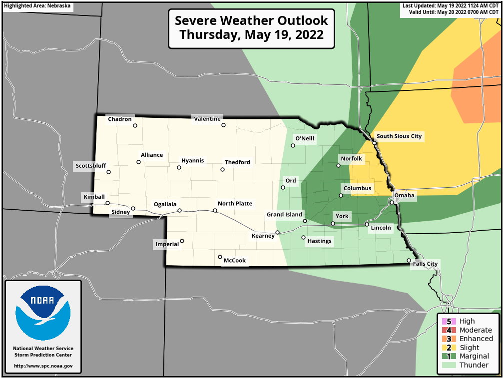
A few strong/severe storms are possible later today/tonight in parts of eastern NE (and especially into parts of IA). The SPC just updated and shifted a portion of the risk area into eastern NE. The risk obviously isn't overly high but something to keep an eye on anyway for isolated damaging wind/hail with storms that are expected to fire north of Omaha along a boundary in the area and move east/northeast into IA...
-
damonhynes
- Parks & Recreation
- Posts: 1282
- Joined: Wed Aug 27, 2014 12:35 am
- Location: Montgomery County, Texas
Re: 2022 Weather Thread
I'm driving to Denver tomorrow, arriving Saturday. Guess who's getting 4-10" with possible thunder? 
-
stormchaser
- Planning Board
- Posts: 2380
- Joined: Fri Jun 01, 2018 1:14 pm
Re: 2022 Weather Thread
damonhynes wrote: Thu May 19, 2022 5:56 pm I'm driving to Denver tomorrow, arriving Saturday. Guess who's getting 4-10" with possible thunder?

...and no thank you, that sounds terrible (though thunder snow is always amazing)
-
BRoss

- IT Director
- Posts: 10003421
- Joined: Sat Aug 05, 2006 12:39 am
- Location: West Central Omaha
Re: 2022 Weather Thread
What's with the cold this next week? It seems to dragging later into the week as we get closer.
-
Busguy2010
- City Council
- Posts: 7380
- Joined: Sun Apr 10, 2011 12:32 am
- Location: North Central Omaha
Re: 2022 Weather Thread
I love it! Today sucks, record heat, humid, windy. I'm glad spring weather is holding on next week, because I know dam well at some point a switch is going to flip, and it will be non-stop scorching hot and humid, kinda like today, until September or October..HR Paperstacks wrote: Thu May 19, 2022 8:39 pm What's with the cold this next week? It seems to dragging later into the week as we get closer.
-
stormchaser
- Planning Board
- Posts: 2380
- Joined: Fri Jun 01, 2018 1:14 pm
Re: 2022 Weather Thread
Yeah, Saturday will be relatively cold because a storm system passing north of here will pull south a shot of colder air into our area from Canada (snow in ND and CO from it).
Then a second piece of energy/low will eject out of the Rockies into our area bringing with it some rain but also preventing it from warming up much after the initial shot of colder air - really until the middle of next week. How long it takes for this low to push east of us far enough for southern winds to kick in will determine how long we stay cold.
Then chances for severe weather start increasing again (possibly) toward the latter half of next week...
-
Omaha Cowboy
- The Don
- Posts: 1013731
- Joined: Wed Jan 07, 2004 11:31 am
- Location: West Omaha
Re: 2022 Weather Thread
No worries. We’ll be back to excellent warm spring weather right before the Memorial Day weekend..HR Paperstacks wrote: Thu May 19, 2022 8:39 pm What's with the cold this next week? It seems to dragging later into the week as we get closer.
Just need to put up with a frigid Saturday..at least we might get more rain out of it..definitely a hoodie day…
Ciao..LiO…Peace
Go Cowboys!
-
stormchaser
- Planning Board
- Posts: 2380
- Joined: Fri Jun 01, 2018 1:14 pm
Re: 2022 Weather Thread
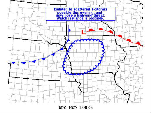
A severe weather watch may be issued for parts of the area soon. Mesoscale discussion is out now…
More info:
https://www.spc.noaa.gov/products/md/md0835.html
More info:
https://www.spc.noaa.gov/products/md/md0835.html
-
BRoss
- IT Director
- Posts: 10003421
- Joined: Sat Aug 05, 2006 12:39 am
- Location: West Central Omaha
Re: 2022 Weather Thread
Hope so! Taking a long weekend and am hoping to spend a lot of time outside.Omaha Cowboy wrote: Thu May 19, 2022 11:37 pmNo worries. We’ll be back to excellent warm spring weather right before the Memorial Day weekend..HR Paperstacks wrote: Thu May 19, 2022 8:39 pm What's with the cold this next week? It seems to dragging later into the week as we get closer.
Just need to put up with a frigid Saturday..at least we might get more rain out of it..definitely a hoodie day…
Ciao..LiO…Peace
When I first saw this coming up, it was just going through Monday but has dragged into Wednesday now. Getting flashbacks of that awful May we had a few years ago where it was way under average for a big portion of the month.
I personally love the heat and am ready for summer! I've been making my backyard my office again this year.

-
stormchaser
- Planning Board
- Posts: 2380
- Joined: Fri Jun 01, 2018 1:14 pm
Re: 2022 Weather Thread
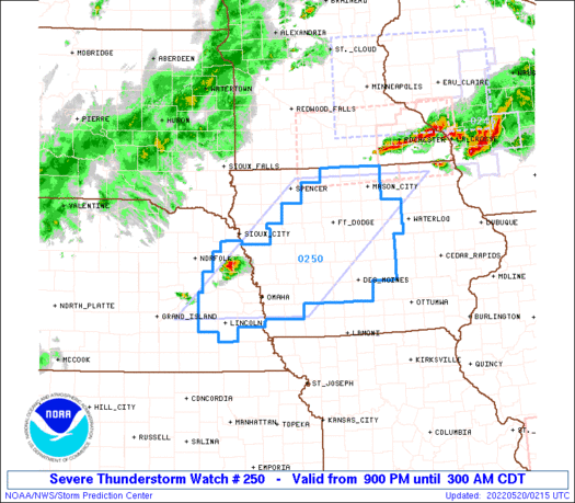
A severe thunderstorm watch has been issued for parts of eastern NE (including Omaha) and IA until 3 AM for a threat for scattered severe storms and potential for 2” diameter hail and 70mph winds.
Even though the watch goes until 3 AM, our threat locally should be mostly over by Midnight roughly, or whenever the front pushes through (well before 3 AM)
More info here:
https://www.spc.noaa.gov/products/watch/ww0250.html
Even though the watch goes until 3 AM, our threat locally should be mostly over by Midnight roughly, or whenever the front pushes through (well before 3 AM)
More info here:
https://www.spc.noaa.gov/products/watch/ww0250.html
-
Brad
- Photographer
- Posts: 1036693
- Joined: Sun Feb 29, 2004 12:03 am
- Location: Omaha, NE
Re: 2022 Weather Thread
Doesn't seem to be moving too fast. Also, the few storms that have popped are behind the front.
Omaha Skyline Photos, Omaha Aerial Photos, and More.
Website: www.bradwilliamsphotography.com
Facebook: www.facebook.com/bradwilliamsphotography
Twitter: www.twitter.com/bradwphoto
Instagram: www.instagram.com/bradwilliamsphotography
YouTube: www.youtube.com/@bradwilliamsphoto
-
Brad
- Photographer
- Posts: 1036693
- Joined: Sun Feb 29, 2004 12:03 am
- Location: Omaha, NE
Re: 2022 Weather Thread
Front is already getting close, nothing on it yet.stormchaser wrote: Fri May 20, 2022 2:21 am
Even though the watch goes until 3 AM, our threat locally should be mostly over by Midnight roughly, or whenever the front pushes through (well before 3 AM)
You do not have the required permissions to view the files attached to this post.
Omaha Skyline Photos, Omaha Aerial Photos, and More.
Website: www.bradwilliamsphotography.com
Facebook: www.facebook.com/bradwilliamsphotography
Twitter: www.twitter.com/bradwphoto
Instagram: www.instagram.com/bradwilliamsphotography
YouTube: www.youtube.com/@bradwilliamsphoto
-
stormchaser
- Planning Board
- Posts: 2380
- Joined: Fri Jun 01, 2018 1:14 pm
Re: 2022 Weather Thread
Yep, they fired on the front and then we’re basically undercut/outrun by the front and left to weaken/die off because of it.Brad wrote: Fri May 20, 2022 2:47 am Doesn't seem to be moving too fast. Also, the few storms that have popped are behind the front.
This is definitely looking like a bust. Either way, front is through Omaha now so our chances are over.
-
stormchaser
- Planning Board
- Posts: 2380
- Joined: Fri Jun 01, 2018 1:14 pm
Re: 2022 Weather Thread
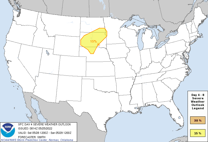
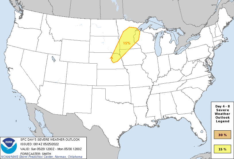
The SPC currently has a day 4 and day 5 outlook (for Saturday/Sunday) for parts of the area for the potential of strong/severe storms. However, in Omaha itself, it looks like there is a decent chance the atmosphere will remain capped in our area preventing storm development from occurring this far south (with the threat staying mostly north of us). If something does fire locally, it will be well after dark as things aloft cool down.
When looking at depicted 700 MB temps, much of the area is expected to be at or above 12c and consequently too warm aloft for storm development (aka "capped"). This remains the case until early to mid next week when temps aloft cool off finally and storm chances increase further south (including in Omaha).
Day 4:
Day 5:
When looking at depicted 700 MB temps, much of the area is expected to be at or above 12c and consequently too warm aloft for storm development (aka "capped"). This remains the case until early to mid next week when temps aloft cool off finally and storm chances increase further south (including in Omaha).
Day 4:
Day 5: