Severe weather this evening
2022 Weather Thread
-
Coyote
- City Council
- Posts: 34365
- Joined: Tue Nov 18, 2003 5:18 pm
- Yahoo Messenger: jestcoyote
- Location: Aksarben Village
-
stormchaser
- Planning Board
- Posts: 2380
- Joined: Fri Jun 01, 2018 1:14 pm
Re: 2022 Weather Thread
Storm that moved through Omaha was pretty outflow dominant though but it did try to wrap up briefly - especially over west Omaha (I watched as I returned home and saw a wall cloud west of 680).
I managed to get on the storm as it developed northwest of Fremont. It went severe warned shortly after I got on it and attempted to wrap up and produce a tornado. However, it ultimately got undercut and failed to produce.
Either way, I’d say my forecast verified pretty well again…
I managed to get on the storm as it developed northwest of Fremont. It went severe warned shortly after I got on it and attempted to wrap up and produce a tornado. However, it ultimately got undercut and failed to produce.
Either way, I’d say my forecast verified pretty well again…
-
stormchaser
- Planning Board
- Posts: 2380
- Joined: Fri Jun 01, 2018 1:14 pm
Re: 2022 Weather Thread
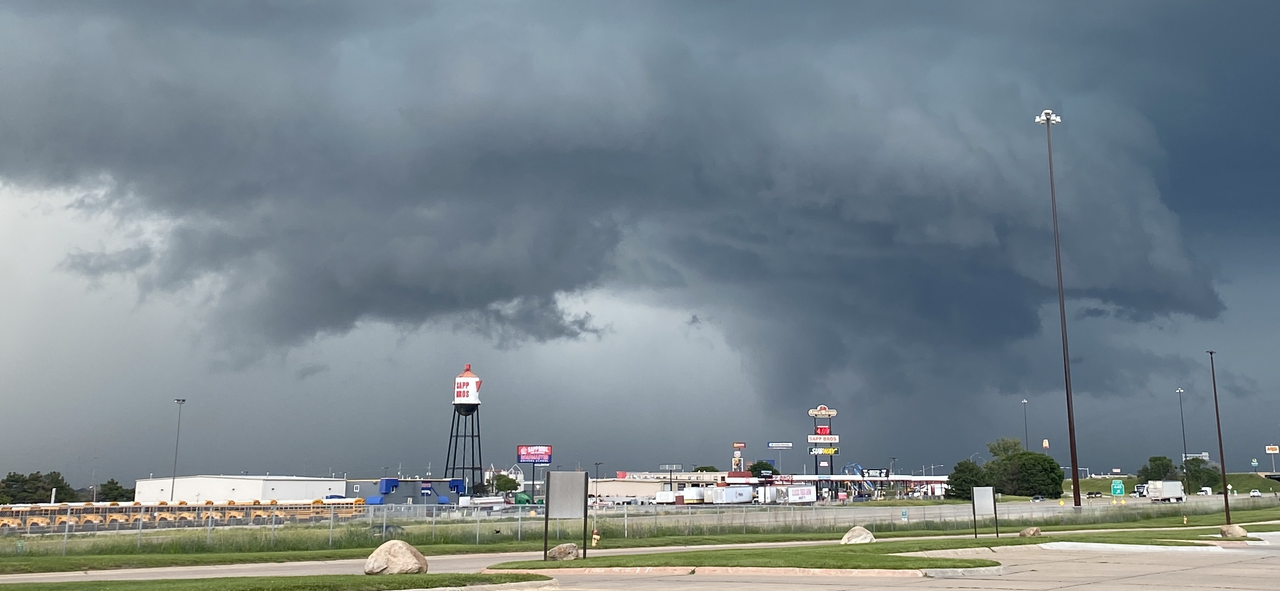
Saw a possible funnel over west Omaha too but it was tough to tell if it was rotating (which means it may have just been scud) and got undercut relatively quickly…but it appeared to be a funnel anyway (just left of the gas station sign). Certainly tried briefly anyway…
Last edited by stormchaser on Sat Jun 11, 2022 11:33 pm, edited 6 times in total.
-
damonhynes

- Parks & Recreation
- Posts: 1282
- Joined: Wed Aug 27, 2014 12:35 am
- Location: Montgomery County, Texas
Re: 2022 Weather Thread
Anthony Copeland's playing fast and loose with the "T" word when describing non-TOR-warned storms. Can't see that Wild Bill Randby likes that much. Wouldn't be surprised if the FCC and/or NOAA pay him a visit.
-
stormchaser
- Planning Board
- Posts: 2380
- Joined: Fri Jun 01, 2018 1:14 pm
Re: 2022 Weather Thread
Lol gotta love TV meteorologists sometimes…damonhynes wrote: Sat Jun 11, 2022 11:25 pm Anthony Copeland's playing fast and loose with the "T" word when describing non-TOR-warned storms. Can't see that Wild Bill Randby likes that much. Wouldn't be surprised if the FCC and/or NOAA pay him a visit.
-
stormchaser
- Planning Board
- Posts: 2380
- Joined: Fri Jun 01, 2018 1:14 pm
Re: 2022 Weather Thread
I also saw and reported a funnel southeast of Maple Creek, NE (northwest of Fremont). All in all a fun local chase…
-
Busguy2010

- City Council
- Posts: 7397
- Joined: Sun Apr 10, 2011 12:32 am
- Location: North Central Omaha
Re: 2022 Weather Thread
TZhat was the first one that developed and looked like it was headed for Omaha, but then drifted more toward the SW suburbs. The one I saw was the one that developed to the north and east of that. It was the second one that hit more toward Central Omaha. I was around Westroads where I saw the low hanging clouds moving different directions.stormchaser wrote: Sat Jun 11, 2022 11:24 pm Saw a possible funnel over west Omaha too but it was tough to tell if it was rotating (which means it may have just been scud) and got undercut relatively quickly…but it appeared to be a funnel anyway (just left of the gas station sign). Certainly tried briefly anyway…
-
stormchaser
- Planning Board
- Posts: 2380
- Joined: Fri Jun 01, 2018 1:14 pm
Re: 2022 Weather Thread
Ahh, niceBusguy2010 wrote: Sun Jun 12, 2022 1:16 amTZhat was the first one that developed and looked like it was headed for Omaha, but then drifted more toward the SW suburbs. The one I saw was the one that developed to the north and east of that. It was the second one that hit more toward Central Omaha. I was around Westroads where I saw the low hanging clouds moving different directions.stormchaser wrote: Sat Jun 11, 2022 11:24 pm Saw a possible funnel over west Omaha too but it was tough to tell if it was rotating (which means it may have just been scud) and got undercut relatively quickly…but it appeared to be a funnel anyway (just left of the gas station sign). Certainly tried briefly anyway…

-
Cermak
- Planning Board
- Posts: 2348
- Joined: Thu Nov 29, 2018 7:02 pm
Re: 2022 Weather Thread
.75 inches of rain at 114th and W. Center area. Had about 30-40 mph gust during the height of storm. I saw no hail. The storm was not as bad as Tuesday's. This might have been the rainiest week we've had so far this year.
According to the forecast this could be our last rain for a while as we will heat up and dry out next week.
According to the forecast this could be our last rain for a while as we will heat up and dry out next week.
-
Busguy2010
- City Council
- Posts: 7397
- Joined: Sun Apr 10, 2011 12:32 am
- Location: North Central Omaha
Re: 2022 Weather Thread
I loathe the upcoming forecast. Save for Wednesday and Thursday (if you consider upper 80's and lower 90's to be tolerable), the upcoming forecast is looking miserable. Particularly tomorrow and Monday. 90s to upper 90s, and lower 100's with dew points in the upper 60s and 70s. All you have to do is stand outside in the shade and you will sweat. Not my cup of tea.Cermak wrote: Sun Jun 12, 2022 2:41 am According to the forecast this could be our last rain for a while as we will heat up and dry out next week.
-
Coyote
- City Council
- Posts: 34365
- Joined: Tue Nov 18, 2003 5:18 pm
- Yahoo Messenger: jestcoyote
- Location: Aksarben Village
Re: 2022 Weather Thread
So sounds like good news, just for the week of the College World Series.Cermak wrote: Sun Jun 12, 2022 2:41 am .75 inches of rain at 114th and W. Center area. Had about 30-40 mph gust during the height of storm. I saw no hail. The storm was not as bad as Tuesday's. This might have been the rainiest week we've had so far this year.
According to the forecast this could be our last rain for a while as we will heat up and dry out next week.
-
stormchaser
- Planning Board
- Posts: 2380
- Joined: Fri Jun 01, 2018 1:14 pm
Re: 2022 Weather Thread
Still a pretty good chance of rain/storms Tuesday night and/or early Wednesday this upcoming week. Otherwise dry and hot...Cermak wrote: Sun Jun 12, 2022 2:41 am According to the forecast this could be our last rain for a while as we will heat up and dry out next week.
-
stormchaser
- Planning Board
- Posts: 2380
- Joined: Fri Jun 01, 2018 1:14 pm
Re: 2022 Weather Thread
Here are a couple of images from a funnel I saw near North Bend, NE (west of Fremont).
This feature was pretty outflowy but occasionally it would try to wrap up and produce. In this case, it wrapped up enough to produce a funnel for a few minutes before being undercut/roping out.
Pretty obvious funnel being pushed by outflow as the feature wrapped up/cycled enough to produce a funnel. I understand this may be difficult to tell from a still image but in video (and in-person) you could see the rotation:
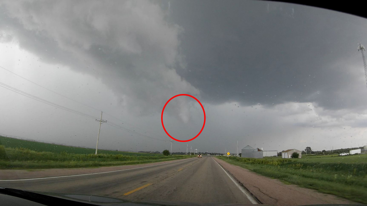
Funnel as it ropes out. A new funnel tried to form just left of this one but things were completely undercut shortly after:
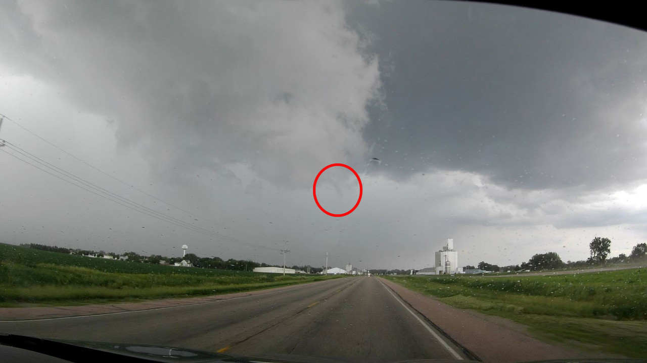
This feature was pretty outflowy but occasionally it would try to wrap up and produce. In this case, it wrapped up enough to produce a funnel for a few minutes before being undercut/roping out.
Pretty obvious funnel being pushed by outflow as the feature wrapped up/cycled enough to produce a funnel. I understand this may be difficult to tell from a still image but in video (and in-person) you could see the rotation:
Funnel as it ropes out. A new funnel tried to form just left of this one but things were completely undercut shortly after:
-
stormchaser
- Planning Board
- Posts: 2380
- Joined: Fri Jun 01, 2018 1:14 pm
Re: 2022 Weather Thread
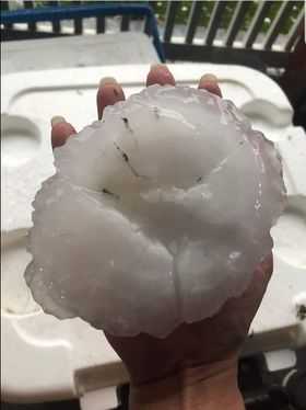
Hail from Beatrice, NE yesterday (not my photo):
-
Louie
- County Board
- Posts: 4968
- Joined: Fri Dec 23, 2011 10:23 pm
- Location: Dundee
Re: 2022 Weather Thread
A lot of trees are showing bacterial infections from all of this boggy soil. Great to get it, but the rate at which we got it was too dang fast. Hopefully this week can dry the topsoil out a bit and prevent more of that. Unfortunately, the grass seed I threw down last week will need a lot more babysitting but oh well.
-
Brad

- Photographer
- Posts: 1036702
- Joined: Sun Feb 29, 2004 12:03 am
- Location: Omaha, NE
Re: 2022 Weather Thread
Nice catch!stormchaser wrote: Sun Jun 12, 2022 1:04 pm Here are a couple of images from a funnel I saw near North Bend, NE (west of Fremont).
This feature was pretty outflowy but occasionally it would try to wrap up and produce. In this case, it wrapped up enough to produce a funnel for a few minutes before being undercut/roping out.
Pretty obvious funnel being pushed by outflow as the feature wrapped up/cycled enough to produce a funnel. I understand this may be difficult to tell from a still image but in video (and in-person) you could see the rotation:
Funnel as it ropes out. A new funnel tried to form just left of this one but things were completely undercut shortly after:

Omaha Skyline Photos, Omaha Aerial Photos, and More.
Website: www.bradwilliamsphotography.com
Facebook: www.facebook.com/bradwilliamsphotography
Twitter: www.twitter.com/bradwphoto
Instagram: www.instagram.com/bradwilliamsphotography
YouTube: www.youtube.com/@bradwilliamsphoto
-
stormchaser
- Planning Board
- Posts: 2380
- Joined: Fri Jun 01, 2018 1:14 pm
Re: 2022 Weather Thread
Thanks!
-
stormchaser
- Planning Board
- Posts: 2380
- Joined: Fri Jun 01, 2018 1:14 pm
Re: 2022 Weather Thread
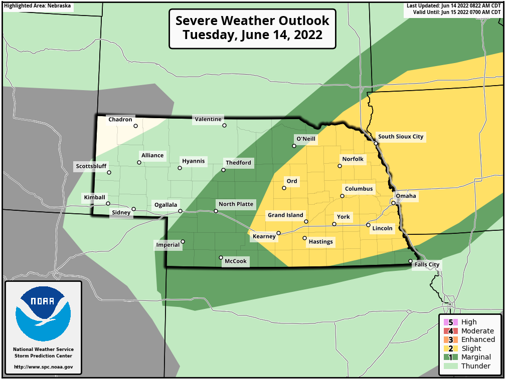
Chance for severe weather in much of eastern NE and IA this evening into the overnight hours. Scattered large hail will be the primary threat though an isolated brief tornado can't completely be ruled out.
-
stormchaser
- Planning Board
- Posts: 2380
- Joined: Fri Jun 01, 2018 1:14 pm
Re: 2022 Weather Thread
Weather geek moment:
Just figured I'd share some insight as to what is going on today with the weather and why things are going to happen the way they are.
Storms are not likely to develop until this evening near or after dark. Why? Because the atmosphere is so hot, storms can't develop (aka, things are capped) until things cool off aloft which won't happen until near or after when the sun sets.
What is a "cap"? Think of a cap on the atmosphere just like you would with a cap on a pop bottle. You can shake up the bottle of pop and produce all kinds of energy because of it (like the energy we have in the atmosphere right now - hence, why it feels gross outside) but until that cap is removed, nothing will happen.
In the case of the atmosphere, a "cap" is simply a layer of warm air aloft (typically found somewhere around the 700 MB level but that can vary). When storms develop, in basic terms what is happening is a column of warm air is rising and condensing, causing a thunderstorm to develop. If this rising warm air hits a layer of air that's as warm or warmer, it can no longer rise. This means the atmosphere is capped. Depending which layer this layer of warm air is found, you can have storms that "try" to develop but never really get going because they hit the cap and then die out (or struggle to maintain their strength). You can also sometimes have storms that develop above the cap - aka, "elevated" storms but depending on where the cap is, they may not end up being all that strong and certainly won't produce tornadoes.
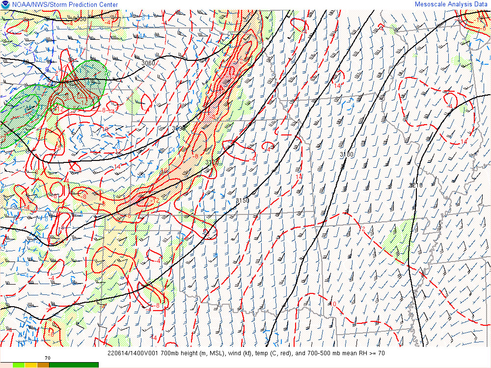
Below are the current 700 MB temps for our area. It can vary from time of year but in general, this time of year anything over 12 C is too warm for storm development. As you can see, much of eastern NE is well over 12 C (the temps are indicated by the red lines). Most of our area is currently in the 14 - 16 C range.
Current 700 MB temps:
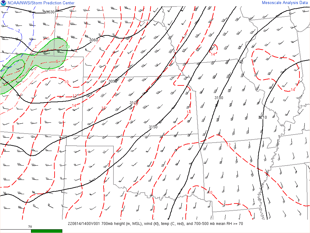
There is a cold front draped across eastern NE currently. You can see this on the map below by looking at the "divergence and vorticity" (one way to see it, lots of other ways obviously). The green, yellow, and orange shaded areas basically represent forcing - aka areas where air is trying to be forced upward to cause storm development. Right now, this area of forcing is sitting in the 16 C 700 MB temp area so until things cool off aloft, nothing will happen. Once it does though, the storms will likely develop FAST (almost like a loaded gun situation - depending on how long it takes to erode the cap).
This map shows the divergence and vorticity overlayed on top of the 700 MB temps so you can more easily see where things are:
Just figured I'd share some insight as to what is going on today with the weather and why things are going to happen the way they are.
Storms are not likely to develop until this evening near or after dark. Why? Because the atmosphere is so hot, storms can't develop (aka, things are capped) until things cool off aloft which won't happen until near or after when the sun sets.
What is a "cap"? Think of a cap on the atmosphere just like you would with a cap on a pop bottle. You can shake up the bottle of pop and produce all kinds of energy because of it (like the energy we have in the atmosphere right now - hence, why it feels gross outside) but until that cap is removed, nothing will happen.
In the case of the atmosphere, a "cap" is simply a layer of warm air aloft (typically found somewhere around the 700 MB level but that can vary). When storms develop, in basic terms what is happening is a column of warm air is rising and condensing, causing a thunderstorm to develop. If this rising warm air hits a layer of air that's as warm or warmer, it can no longer rise. This means the atmosphere is capped. Depending which layer this layer of warm air is found, you can have storms that "try" to develop but never really get going because they hit the cap and then die out (or struggle to maintain their strength). You can also sometimes have storms that develop above the cap - aka, "elevated" storms but depending on where the cap is, they may not end up being all that strong and certainly won't produce tornadoes.
Below are the current 700 MB temps for our area. It can vary from time of year but in general, this time of year anything over 12 C is too warm for storm development. As you can see, much of eastern NE is well over 12 C (the temps are indicated by the red lines). Most of our area is currently in the 14 - 16 C range.
Current 700 MB temps:
There is a cold front draped across eastern NE currently. You can see this on the map below by looking at the "divergence and vorticity" (one way to see it, lots of other ways obviously). The green, yellow, and orange shaded areas basically represent forcing - aka areas where air is trying to be forced upward to cause storm development. Right now, this area of forcing is sitting in the 16 C 700 MB temp area so until things cool off aloft, nothing will happen. Once it does though, the storms will likely develop FAST (almost like a loaded gun situation - depending on how long it takes to erode the cap).
This map shows the divergence and vorticity overlayed on top of the 700 MB temps so you can more easily see where things are:
-
Louie
- County Board
- Posts: 4968
- Joined: Fri Dec 23, 2011 10:23 pm
- Location: Dundee
Re: 2022 Weather Thread
With all that in mind, what are your predictions for the Omaha Metro for the night?
-
almighty_tuna
- City Council
- Posts: 106415
- Joined: Tue Apr 13, 2004 6:34 pm
- Location: Somewhere between downtown and Colorado
Re: 2022 Weather Thread
This is great content to this armchair weather enthusiast
-
Brad
- Photographer
- Posts: 1036702
- Joined: Sun Feb 29, 2004 12:03 am
- Location: Omaha, NE
Re: 2022 Weather Thread
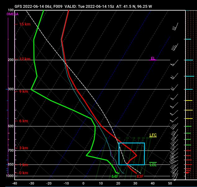
Usually easy to detect in a Skew-T. From what I have read in the past, when the Temperature (Red) goes to the right of the Lapse Rate (White Dashed Line), that's the cap, and like you said, Skew-T shows it right around the 700MB level. Someone correct me if I am wrong.stormchaser wrote: Tue Jun 14, 2022 2:49 pm In the case of the atmosphere, a "cap" is simply a layer of warm air aloft (typically found somewhere around the 700 MB level but that can vary). When storms develop, in basic terms what is happening is a column of warm air is rising and condensing, causing a thunderstorm to develop. If this rising warm air hits a layer of air that's as warm or warmer, it can no longer rise. This means the atmosphere is capped. Depending which layer this layer of warm air is found, you can have storms that "try" to develop but never really get going because they hit the cap and then die out (or struggle to maintain their strength). You can also sometimes have storms that develop above the cap - aka, "elevated" storms but depending on where the cap is, they may not end up being all that strong and certainly won't produce tornadoes.
You do not have the required permissions to view the files attached to this post.
Omaha Skyline Photos, Omaha Aerial Photos, and More.
Website: www.bradwilliamsphotography.com
Facebook: www.facebook.com/bradwilliamsphotography
Twitter: www.twitter.com/bradwphoto
Instagram: www.instagram.com/bradwilliamsphotography
YouTube: www.youtube.com/@bradwilliamsphoto
-
stormchaser
- Planning Board
- Posts: 2380
- Joined: Fri Jun 01, 2018 1:14 pm
Re: 2022 Weather Thread
Right now, it looks like storms will develop around 8ish south of Lincoln and "maybe" eventually move up to near or just south of Omaha around 10 PM. However, based on the last several HRRR model runs, they are likely struggling with the cap as they move in so they may not reach severe potential in our area (impossible to know at this point).Louie wrote: Tue Jun 14, 2022 3:08 pm With all that in mind, what are your predictions for the Omaha Metro for the night?
Otherwise, "most" of the hail threat looks to be west of Omaha based on the HRRR anyway. Obviously don't let down your guard here in Omaha but given the fact most of the big hail/severe weather producers are expected to be scattered and depicted west of here, Omaha itself may dodge the bullet this time.
I'll probably post an update later this evening (before storms develop) if it looks like things have changed...
-
stormchaser
- Planning Board
- Posts: 2380
- Joined: Fri Jun 01, 2018 1:14 pm
Re: 2022 Weather Thread
Yep, you're spot on. The Skew-T is the best way to check capping when looking at a single specific area (that way you can see exactly what level it's at and to what extent for that given location). Something I use all the time when chasing (and to check wind directions at different levels, etc obviously).Brad wrote: Tue Jun 14, 2022 3:27 pm Usually easy to detect in a Skew-T. From what I have read in the past, when the Temperature (Red) goes to the right of the Lapse Rate (White Dashed Line), that's the cap, and like you said, Skew-T shows it right around the 700MB level. Someone correct me if I am wrong.
Think of the Skew-T as the readings/measurements given when sending a weather balloon up into the atmosphere. The red line is the temp it reads as it is rising (temp is the scale found at the very bottom of the Skew-T), the green line is the dewpoint and the dashed line represents instability (basically). The height or portion of the atmosphere the reading is for is found on the far left of the Skew T (indicated by for example "1000 MB" which is found near the surface and between 200 MB and 300 MB where you typically find the jet stream - 500 MB is often where you'll find the "steering winds" that determine what direction the storm will move - in this case, it would move northeasterly).
I outlined in light blue the area on the Skew-T that is capped. If you look at the scale at the bottom, you can see that "wedge" is warmer than the air trying to rise by ~5 C so until that area cools off, storm development is unlikely (at least not anything surface-based anyway).
Last edited by stormchaser on Tue Jun 14, 2022 4:02 pm, edited 2 times in total.
-
damonhynes
- Parks & Recreation
- Posts: 1282
- Joined: Wed Aug 27, 2014 12:35 am
- Location: Montgomery County, Texas
Re: 2022 Weather Thread
And to make things even more angsty, no cap is as bad as a thermonuclear cap.
-
stormchaser
- Planning Board
- Posts: 2380
- Joined: Fri Jun 01, 2018 1:14 pm
Re: 2022 Weather Thread
Yep, not enough capping will mean way too many storms will develop at the same time competing for energy with each other and you'll end up with more of a heavy rain event than a severe weather event...damonhynes wrote: Tue Jun 14, 2022 4:01 pm And to make things even more angsty, no cap is as bad as a thermonuclear cap.
-
stormchaser
- Planning Board
- Posts: 2380
- Joined: Fri Jun 01, 2018 1:14 pm
Re: 2022 Weather Thread
Updated my thoughts about what will happen with storms in our area later today which includes what I feel is a higher threat for in Omaha itself than I thought this morning (I'll explain why below). To clarify, I am not a meterologist. I am a self-taught forecaster (who has forecasted severe weather for ~15 years and chased storms since 2006). Regardless, always rely on official forecast information. This is simply my opinion
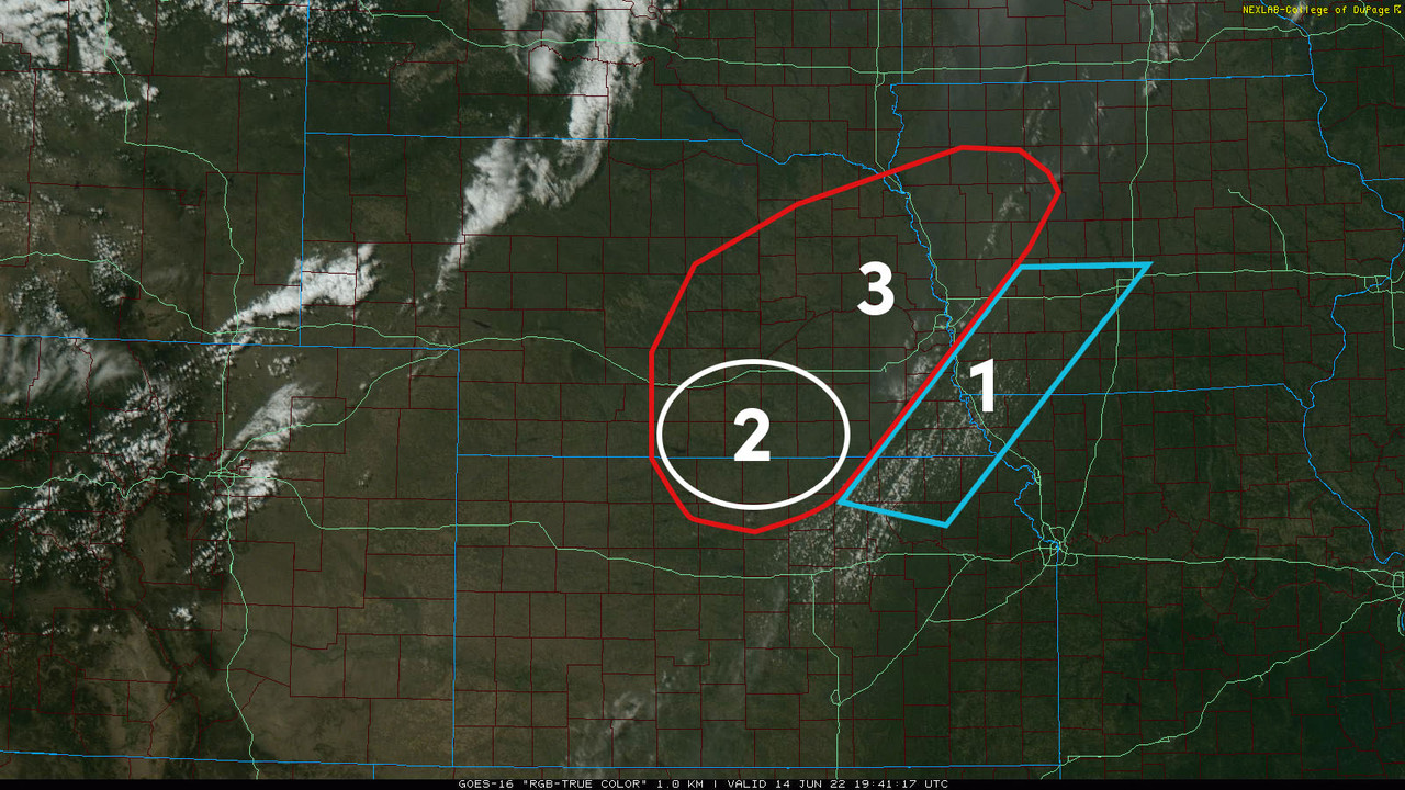
On the map below, I have numbered and outlined 3 different areas. Each of these areas are explained below.
1. Between 6 PM and 9 PM, elevated storms will probably develop in this area and move northeasterly. Most of these storms should remain below severe weather criteria though a few isolated severe warned storms can't be ruled out (for hail mostly). As a result of these storms, I feel it is less likely this area will receive severe weather later (due to the atmosphere becoming more stabilized). Earlier this morning, there was some question as to where this early round of storms would end up, which made the severe weather threat in Omaha itself less certain. It now appears these storms will end up far enough east that Omaha will "probably" be at risk later this evening/overnight, but it's tough to really know. If these storms end up moving far enough north into Omaha, then our threat later will decrease (so this is something to keep a close eye on).
2. This area along the NE/KS border and south of I-80 is where I expect the main round of severe weather to start developing this evening (mostly after 8 PM - possibly as late as Midnight). These storms will likely track northeast and pose a risk of large hail (possibly very large hail), damaging wind, and at least a low-end tornado threat.
3. This is the main area at risk for large hail/damaging wind/isolated tornadoes IMO this evening into the overnight hours. Some of these storms may not really get going until after 10 PM (possibly even after Midnight). Again, some of these storms will probably produce some very large hail in places though those areas will be scattered. The main threat continues to be west of Omaha - but Omaha might see some large hail too (depending on exactly where the storm's track later).
On the map below, I have numbered and outlined 3 different areas. Each of these areas are explained below.
1. Between 6 PM and 9 PM, elevated storms will probably develop in this area and move northeasterly. Most of these storms should remain below severe weather criteria though a few isolated severe warned storms can't be ruled out (for hail mostly). As a result of these storms, I feel it is less likely this area will receive severe weather later (due to the atmosphere becoming more stabilized). Earlier this morning, there was some question as to where this early round of storms would end up, which made the severe weather threat in Omaha itself less certain. It now appears these storms will end up far enough east that Omaha will "probably" be at risk later this evening/overnight, but it's tough to really know. If these storms end up moving far enough north into Omaha, then our threat later will decrease (so this is something to keep a close eye on).
2. This area along the NE/KS border and south of I-80 is where I expect the main round of severe weather to start developing this evening (mostly after 8 PM - possibly as late as Midnight). These storms will likely track northeast and pose a risk of large hail (possibly very large hail), damaging wind, and at least a low-end tornado threat.
3. This is the main area at risk for large hail/damaging wind/isolated tornadoes IMO this evening into the overnight hours. Some of these storms may not really get going until after 10 PM (possibly even after Midnight). Again, some of these storms will probably produce some very large hail in places though those areas will be scattered. The main threat continues to be west of Omaha - but Omaha might see some large hail too (depending on exactly where the storm's track later).
-
stormchaser
- Planning Board
- Posts: 2380
- Joined: Fri Jun 01, 2018 1:14 pm
Re: 2022 Weather Thread
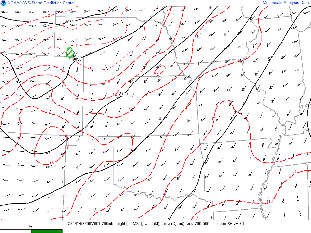
As of ~4:50 PM, the 700 MB temps have started to cool off a fair amount with 12 C from Grand Island up toward the northwest side of Omaha and 10 C just west of that. It "could" mean storms will develop a bit earlier than expected but it still won't be until this evening for most areas (and still may not be until after dark for many areas). I still expect the main severe weather to develop initially in the white outlined area in the map I posted earlier (possibly a bit further south into KS but a similar area anyway) and the red outlined area to have most of the severe weather risk.
-
stormchaser
- Planning Board
- Posts: 2380
- Joined: Fri Jun 01, 2018 1:14 pm
Re: 2022 Weather Thread
Storm initiation is starting to occur currently in the Grand Island/Hastings area (as expected and as I indicated would happen on my map I posted earlier). This is likely the beginning of the main severe weather threat for tonight across much eastern NE and western IA.
MD was also just issued for much of the area (including Omaha) for the possibility of a watch soon being needed. Large hail will be the main threat initially and then storms will transition to more of a damaging wind threat into the overnight hours.
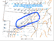
Relatively strong storms are forming just west of Omaha as well and will move through over the next hour (as well as a severe warned storm for hail southeast of Omaha). Large hail may be a threat with these storms - but the main threat will be with the stuff further west (IMO).
MD was also just issued for much of the area (including Omaha) for the possibility of a watch soon being needed. Large hail will be the main threat initially and then storms will transition to more of a damaging wind threat into the overnight hours.
Relatively strong storms are forming just west of Omaha as well and will move through over the next hour (as well as a severe warned storm for hail southeast of Omaha). Large hail may be a threat with these storms - but the main threat will be with the stuff further west (IMO).
-
Brad
- Photographer
- Posts: 1036702
- Joined: Sun Feb 29, 2004 12:03 am
- Location: Omaha, NE
Re: 2022 Weather Thread
Dang, quite a hook heading towards Lincoln!

Omaha Skyline Photos, Omaha Aerial Photos, and More.
Website: www.bradwilliamsphotography.com
Facebook: www.facebook.com/bradwilliamsphotography
Twitter: www.twitter.com/bradwphoto
Instagram: www.instagram.com/bradwilliamsphotography
YouTube: www.youtube.com/@bradwilliamsphoto
-
Busguy2010
- City Council
- Posts: 7397
- Joined: Sun Apr 10, 2011 12:32 am
- Location: North Central Omaha
Re: 2022 Weather Thread
That's the most impressive hook echo I've seen anywhere near in line for Omaha in quite a while. Looks like it will pass to our South, but still, I'm going to stay awake until we in Omaha proper are in the clear. If I was in Papillion, Bellevue, Plattsmouth, I'd be a bit more concerned.
-
Busguy2010
- City Council
- Posts: 7397
- Joined: Sun Apr 10, 2011 12:32 am
- Location: North Central Omaha
Re: 2022 Weather Thread
That's a bad Mother F...
-
Brad
- Photographer
- Posts: 1036702
- Joined: Sun Feb 29, 2004 12:03 am
- Location: Omaha, NE
Re: 2022 Weather Thread
Randby said if it weakens it will start to drift north, if it stays strong will will continue to march east.Busguy2010 wrote: Wed Jun 15, 2022 3:45 am That's the most impressive hook echo I've seen anywhere near in line for Omaha in quite a while. Looks like it will pass to our South, but still, I'm going to stay awake until we in Omaha proper are in the clear. If I was in Papillion, Bellevue, Plattsmouth, I'd be a bit more concerned.
Omaha Skyline Photos, Omaha Aerial Photos, and More.
Website: www.bradwilliamsphotography.com
Facebook: www.facebook.com/bradwilliamsphotography
Twitter: www.twitter.com/bradwphoto
Instagram: www.instagram.com/bradwilliamsphotography
YouTube: www.youtube.com/@bradwilliamsphoto
-
Busguy2010
- City Council
- Posts: 7397
- Joined: Sun Apr 10, 2011 12:32 am
- Location: North Central Omaha
Re: 2022 Weather Thread
I didn't hear him say that, but I was thinking that to myself looking at the radar. The part of the storm to the south kind of looks like it is wrapping up to the north, so I won't be surprised it we get a little taste of it, especially more toward the south part of the metro.Brad wrote: Wed Jun 15, 2022 3:52 am Randby said if it weakens it will start to drift north, if it stays strong will will continue to march east.
And as I'm typing, it does look like its trending more northeast than due east like it was earlier. I'm definitely going to stay on watch.
-
Brad
- Photographer
- Posts: 1036702
- Joined: Sun Feb 29, 2004 12:03 am
- Location: Omaha, NE
Re: 2022 Weather Thread
There is also another round out by Grand Island/Kearney.
Omaha Skyline Photos, Omaha Aerial Photos, and More.
Website: www.bradwilliamsphotography.com
Facebook: www.facebook.com/bradwilliamsphotography
Twitter: www.twitter.com/bradwphoto
Instagram: www.instagram.com/bradwilliamsphotography
YouTube: www.youtube.com/@bradwilliamsphoto
-
Busguy2010
- City Council
- Posts: 7397
- Joined: Sun Apr 10, 2011 12:32 am
- Location: North Central Omaha
Re: 2022 Weather Thread
Rob McCartney is playing a good co-pilot tonight, I didn't know he had or would do that.
-
Busguy2010
- City Council
- Posts: 7397
- Joined: Sun Apr 10, 2011 12:32 am
- Location: North Central Omaha
Re: 2022 Weather Thread
So this storm currently coming up the pike is part of the first wave they were mentioning, and that one that has developed out by GI is the second wave that might come by about 3 or 4 am.
-
stormchaser
- Planning Board
- Posts: 2380
- Joined: Fri Jun 01, 2018 1:14 pm
Re: 2022 Weather Thread
So far the threat has played out pretty much as I expected with my forecast earlier (aside from the severe storms extending further west toward McCook, NE). Lots of storms/severe weather yet to come for much of the area (as mentioned already by others).
-
Busguy2010
- City Council
- Posts: 7397
- Joined: Sun Apr 10, 2011 12:32 am
- Location: North Central Omaha
Re: 2022 Weather Thread
Looks like most of us are pretty much in the clear for now. Will be waiting a few more hours for what is coming out of Kearney. Just an absolute train of severe thunderstorm warnings. Have about 10 successive severe thunderstorm warnings out of those storms as of now.
-
damonhynes
- Parks & Recreation
- Posts: 1282
- Joined: Wed Aug 27, 2014 12:35 am
- Location: Montgomery County, Texas
Re: 2022 Weather Thread
Interesting night. I live in Springfield, and if that meso had gone six miles further north, I'd be brushpopping my crappy locust trees right now.
What a difference twenty years makes in commercial radar technology.
What a difference twenty years makes in commercial radar technology.