damonhynes wrote: Wed Jun 15, 2022 2:23 pm
Interesting night. I live in Springfield, and if that meso had gone six miles further north, I'd be brushpopping my crappy locust trees right now.
What a difference twenty years makes in commercial radar technology.
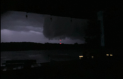
We were at my folks place in Cedar Creek as our floors are getting finished and we got to see that wall cloud as it passed to the south, really intimidating.
damonhynes wrote: Wed Jun 15, 2022 2:23 pm
Interesting night. I live in Springfield, and if that meso had gone six miles further north, I'd be brushpopping my crappy locust trees right now.
What a difference twenty years makes in commercial radar technology.
We were at my folks place in Cedar Creek as our floors are getting finished and we got to see that wall cloud as it passed to the south, really intimidating.
Sorry for potato quality lol
Wow..
That looks dangerous and ominous. I’d hate to see that coming at me…
damonhynes wrote: Wed Jun 15, 2022 2:23 pm
Interesting night. I live in Springfield, and if that meso had gone six miles further north, I'd be brushpopping my crappy locust trees right now.
What a difference twenty years makes in commercial radar technology.
We were at my folks place in Cedar Creek as our floors are getting finished and we got to see that wall cloud as it passed to the south, really intimidating.
Sorry for potato quality lol
Wow..
That looks dangerous and ominous. I’d hate to see that coming at me…
Ciao..LiO…Peace
Luckily that is facing southeast, so we were mostly out of harm's way by the time I snapped it.
Thunderstorms swept through eastern Nebraska late Tuesday and early Wednesday, downing tree limbs and causing numerous power outages. The National Weather Service office in Valley said it received reports of five potential tornadoes. Wednesday morning, the agency sent out survey teams to inspect the damage to determine if tornadoes did indeed occur and if so, how strong they were. One tornado report came in from near the Pleasant Dale exit along Interstate 80 in Lancaster County and another came from rural Pottawattamie County near Carson, Iowa.
damonhynes wrote: Wed Jun 15, 2022 2:23 pm
Interesting night. I live in Springfield, and if that meso had gone six miles further north, I'd be brushpopping my crappy locust trees right now.
What a difference twenty years makes in commercial radar technology.
We were at my folks place in Cedar Creek as our floors are getting finished and we got to see that wall cloud as it passed to the south, really intimidating.
Sorry for potato quality lol
Wow..
That looks dangerous and ominous. I’d hate to see that coming at me…
Ciao..LiO…Peace
Luckily that is facing southeast, so we were mostly out of harm's way by the time I snapped it.
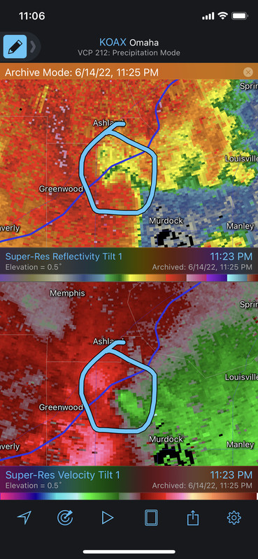
Yep, definitely mean looking. From what it sounds like, there "may" have been tornado damage near Greenwood (at a campground near there). I'm assuming a damage survey will be done...
I'd be pretty surprised if this wasn't at least a brief tornado between Greenwood & Ashland just east of I-80 based on radar. Guess we will see what the damage survey shows though...
Thunderstorms swept through eastern Nebraska and western Iowa late Tuesday and early Wednesday, downing tree limbs and causing numerous power outages. The National Weather Service office in Valley said it received reports of five potential tornadoes. Wednesday morning, the agency sent out survey teams to inspect the damage to determine if tornadoes did indeed occur and if so, how strong they were.
One tornado report came in from near the Pleasant Dale exit along Interstate 80 in Lancaster County and another came from rural Pottawattamie County near Carson. "We are getting ready to head out to five or six spots that we want to check," said meteorologist Taylor Nicolaisen. "There were reports (of possible tornadoes) west of Lincoln, east of Waverly and near Plattsmouth and Glenwood (Iowa)."
A weather service spokesman said the storms, including hail, kicked up in Seward County and continued into western Iowa. The weather service received dozens of reports of large hail, including some stones slightly larger than golf balls. Hail damage was reported to crops in Lancaster County and to trees and shrubs along the path of the storm, including in York.
A deer looks at a fallen tree Wednesday on Terry Avenue near Sherry Drive in Bellevue. A storm that came through overnight brought high winds and, in some places, hail.
Louie wrote: Wed Jun 15, 2022 8:17 pm
Definitely curious to see the tornado path maps if there were 5 of them.
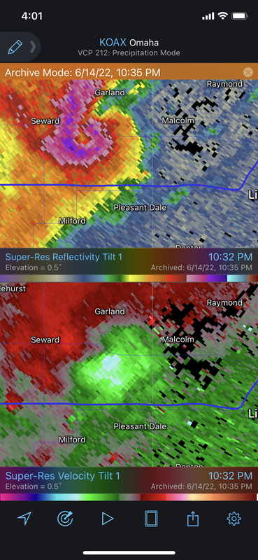
Honestly, the one reported west of Lincoln (at the Pleasant Dale exit along I-80 according to the report) makes no sense - it was too far south to be a tornado. Based on radar, damage here was likely from RFD with the actual area of rotation/potential tornado passing a few miles north of this location between Seward and Malcolm (image below showing what I'm referring to).
The rest of the potential tornadoes I'm sure are from the same parent storm/meso with it cycling several times and producing occasional tornadoes along its path as it moved east/northeast to just south of Omaha..
Radar showing the potential tornado between Seward and Malcolm:
POTTAWATTAMIE COUNTY, Iowa — Severe thunderstorms caused a swath of damage across southeast Nebraska and western Iowa. A winery in Pottawattamie County is among the reported damage. Strong winds tore the roof off the Prairie Crossing Winery in Treynor, Iowa. The owners have been forced to close for now, but the community came together within hours to help clean up. "It's so surreal to look at, because I was just out here yesterday and everything was in tact, it was a beautiful day" owner Doug Gray said. "Now within 24 hours, it's gone."
The National Weather Service said Wednesday it would send crews out to survey areas for damage, but initially reported hail the size of teacups caused substantial damage to trees, crops and vehicles. The Treynor football team helped lead the clean-up efforts and within an hour all of the trees had been cleared. "We've got amazing support from the Treynor community," Gray said.
Louie wrote: Wed Jun 15, 2022 8:17 pm
Definitely curious to see the tornado path maps if there were 5 of them.
Honestly, the one reported west of Lincoln (at the Pleasant Dale exit along I-80 according to the report) makes no sense - it was too far south to be a tornado. Based on radar, damage here was likely from RFD with the actual area of rotation/potential tornado passing a few miles north of this location between Seward and Malcolm (image below showing what I'm referring to).
The rest of the potential tornadoes I'm sure are from the same parent storm/meso with it cycling several times and producing occasional tornadoes along its path as it moved east/northeast to just south of Omaha..
Radar showing the potential tornado between Seward and Malcolm:
That was one powerful supercell.. And packed a punch for several hours…
Cermak wrote: Wed Jun 15, 2022 10:47 pm
Had another 2 inches of rain last night in SW Omaha. This has been a really rainy stretch lately. Are we still in a drought ?
I don't think we are technically. Mild at most. However, though, I can attest that locally I've likely had several inches (might have had 3+ just last night) in the past two weeks, Eppley has only reported 1.8" on the month and that's how it will go down in the history books.
I personally have seen enough rain that my plants and trees are showing signs that they want a break like real bad.
Cermak wrote: Wed Jun 15, 2022 10:47 pm
Had another 2 inches of rain last night in SW Omaha. This has been a really rainy stretch lately. Are we still in a drought ?
I don't think we are technically. Mild at most. However, though, I can attest that locally I've likely had several inches (might have had 3+ just last night) in the past two weeks, Eppley has only reported 1.8" on the month and that's how it will go down in the history books.
I personally have seen enough rain that my plants and trees are showing signs that they want a break like real bad.
I just heard Eppley reported 1.8" on the event last night/early this morning. So that should make for about 3.6" on the month (won't know until 12:52 am). If Eppley reports ~3.6" we will only be behind by about .8" at the halfway mark of June. Though, I do acknowledge that many of us have seen much more than what was reported at the airport the last few weeks.
Cermak wrote: Wed Jun 15, 2022 10:47 pm
Had another 2 inches of rain last night in SW Omaha. This has been a really rainy stretch lately. Are we still in a drought ?
I don't think we are technically. Mild at most. However, though, I can attest that locally I've likely had several inches (might have had 3+ just last night) in the past two weeks, Eppley has only reported 1.8" on the month and that's how it will go down in the history books.
I personally have seen enough rain that my plants and trees are showing signs that they want a break like real bad.
I just heard Eppley reported 1.8" on the event last night/early this morning. So that should make for about 3.6" on the month (won't know until 12:52 am). If Eppley reports ~3.6" we will only be behind by about .8" at the halfway mark of June. Though, I do acknowledge that many of us have seen much more than what was reported at the airport the last few weeks.
I had 1.8” also with this latest storm about 8 Mi NW of Eppley. Decent soaker.
Last edited by GetUrban on Thu Jun 16, 2022 3:58 am, edited 1 time in total.
He said "They are some big, ugly red brick buildings" ...and then they were gone.
Looks like 2 confirmed tornadoes out of this (not sure if they're done investigating or not so there may be more).
Both tornadoes were EF-1. The one that I suspected between Greenwood/Ashland east of I-80 (north of Murdock) and the other near Glenwood (that hit the winery).
Strong to severe storms are possible in parts of the area again this evening/tonight (as the temps aloft cool off - aka, capping weakens). Damaging wind and hail will be the main threats though isolated tornadoes are possible as well.
Based on the 12z HRRR, don't be surprised if we get storms in (or close to) Omaha. Better chance obviously south of town but exactly where the east/west boundary sets up will be key in whether Omaha gets hit or not.
GetUrban wrote: Thu Jun 16, 2022 3:53 am
I had 1.8” also with this latest storm about 8 Mi NW of Eppley. Decent soaker.
So they didn't report 1.8" on the day... So we are now sitting at 2.93" for June, with a little less than half the month to go. So we have 14 days to get 1.51" more if we don't want to report a deficit... Even though I kinda say that in jest because although Eppley has seemed to be a relatively dry spot this month. Locally, we have all reported much more than Eppley. But it is what it is, that's what gets reported.
If you click this link https://www.weather.gov/oax/monthly_climate_records and look at June 13th, you can see that the record high of 101 is in the year 9999, so maybe we don't have so much to worry about with climate change
stormchaser wrote: Thu Jun 16, 2022 1:20 pm
Based on the 12z HRRR, don't be surprised if we get storms in (or close to) Omaha. Better chance obviously south of town but exactly where the east/west boundary sets up will be key in whether Omaha gets hit or not.
The 17z run of the model shows storms forming over Omaha around 04z and still sitting on us at 11z. Nothing like 5 straight hours of rain...
stormchaser wrote: Thu Jun 16, 2022 1:20 pm
Based on the 12z HRRR, don't be surprised if we get storms in (or close to) Omaha. Better chance obviously south of town but exactly where the east/west boundary sets up will be key in whether Omaha gets hit or not.
The 17z run of the model shows storms forming over Omaha around 04z and still sitting on us at 11z. Nothing like 5 straight hours of rain...
Yep, that would be pretty crazy. Looking like a decent chance there will be some heavy rain in the area this evening either way though.
A few storms have attempted to form along the boundary near Omaha (mostly south of town currently) over the last hour or 2. They are struggling to strengthen though due to capping and a lack of wind shear currently - and that probably won't change anytime soon. Additional storms may attempt to form along this boundary over the next couple of hours. If they do, it is unlikely they will become severe for the time being.
This evening, wind shear will increase in the area, and with this boundary near or over Omaha, I'd expect some severe storms locally (mostly for hail/damaging wind) - especially on the southwest side of Omaha. However, there also is a tornado threat (IMO) not too far away from Omaha based on the depicted ESRH levels later on. If a storm can remain discrete enough and embed on the boundary, it certainly has the type of environment where it could spin up a tornado. Odds are low obviously but still possible.
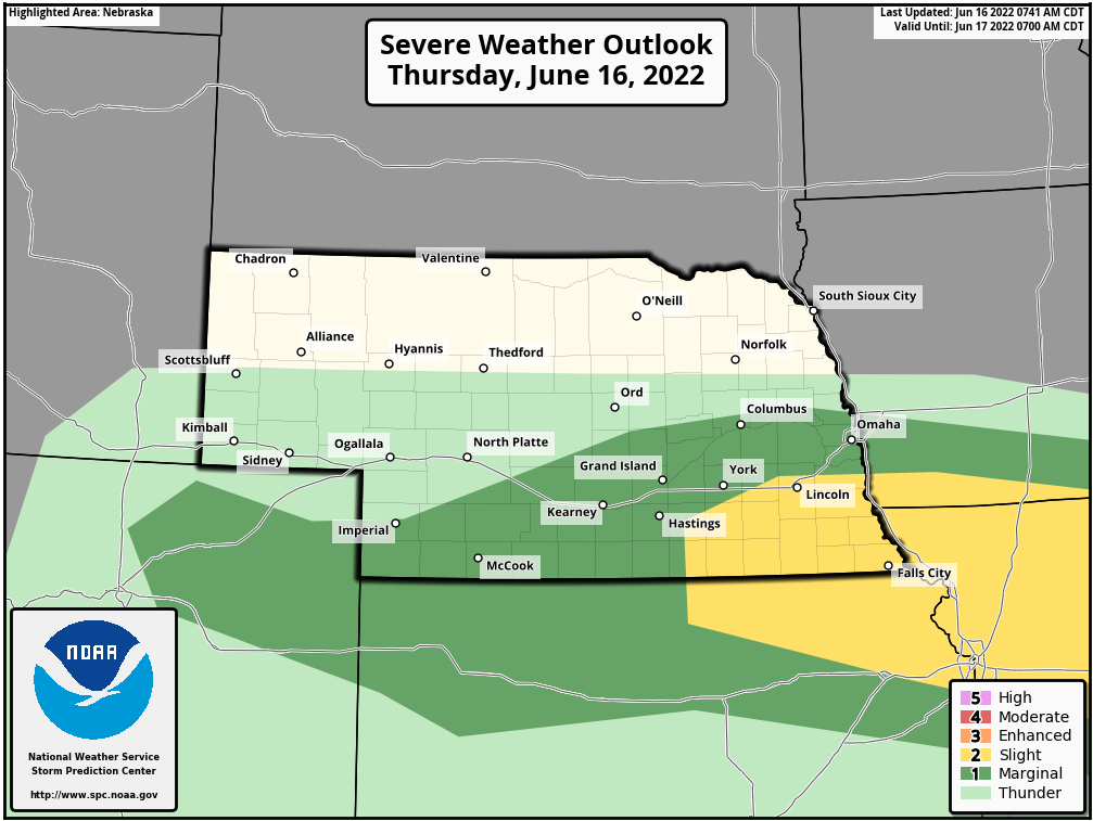
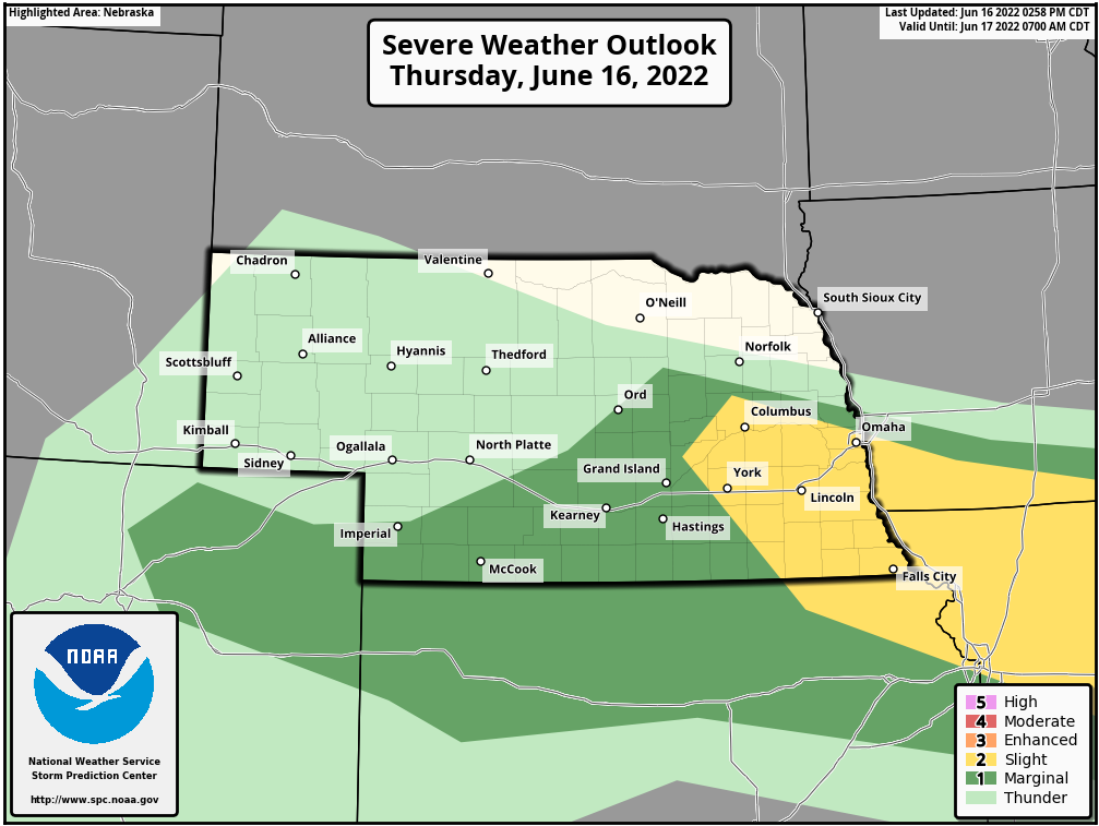
As I was typing this, the SPC actually shifted the severe risk area further north and now includes Omaha:
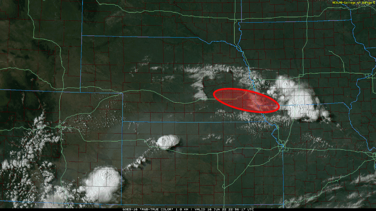
My thoughts about the severe weather this evening based on the mesoanalysis and visible satellite as well as the last several runs of the HRRR forecast model.
The area outlined in red is the primary area at risk for severe weather. The main threats are large hail and damaging wind. However, there is a low end tornado threat - especially if any of the storms can remain discrete enough and can embed on the northwest to southeast boundary moving north into the area. Omaha itself "might" get missed to the southwest (but it will be close) but LIncoln looks to have an interesting evening...
Storm development should occur sometime between 8 PM - 10 PM in the outlined area.
Not looking like it's going to cool off anytime soon based on the 12z ECMWF aside from a brief possible cool down (upper 80s) on Wednesday, June 22nd (with possible storms Tuesday night). Otherwise, every day in the long-range (from tomorrow through June 26th) looks to be at least 90 with at least a few days where we may be pushing/exceeding 100.
Of course, take any long-range forecast with a grain of salt because it can change quickly - but that's how it looks currently anyway.
At this point, I'd be happy even with just normal, which is 85,86,87 over the rest of the month. This 5-15 degrees above normal crud is for the birds. After that very brief relative cool down on Wednesday, its back to more of this. Monday is going to be brutal with a forecast heat index of 106.
82 on Wednesday won't be to bad, then low 90's after that. I would rather have the heat instead of severe weather. I was just outside even though it's still 81 at 11:30pm the humidity doesn't seem real bad.
Yeah, things have trended cooler already with long range models. Monday will be pretty bad with temps above 100 and humid. Still might see a few mid to upper 90 days toward the end of the week/next weekend too. Overall not terrible and not as bad as it had been looking but definitely some hot days in there.
stormchaser wrote: Sun Jun 19, 2022 8:05 am
Yeah, things have trended cooler already with long range models. Monday will be pretty bad with temps above 100 and humid. Still might see a few mid to upper 90 days toward the end of the week/next weekend too. Overall not terrible and not as bad as it had been looking but definitely some hot days in there.
Seems like pretty typical early summer in Omaha..
I don’t mind the summertime temps, but the highs in the 100’s can bow out anytime now, lol…
stormchaser wrote: Sun Jun 19, 2022 8:05 am
Yeah, things have trended cooler already with long range models. Monday will be pretty bad with temps above 100 and humid. Still might see a few mid to upper 90 days toward the end of the week/next weekend too. Overall not terrible and not as bad as it had been looking but definitely some hot days in there.
Seems like pretty typical early summer in Omaha..
I don’t mind the summertime temps, but the highs in the 100’s can bow out anytime now, lol…
stormchaser wrote: Sun Jun 19, 2022 8:05 am
Yeah, things have trended cooler already with long range models. Monday will be pretty bad with temps above 100 and humid. Still might see a few mid to upper 90 days toward the end of the week/next weekend too. Overall not terrible and not as bad as it had been looking but definitely some hot days in there.
Seems like pretty typical early summer in Omaha..
I don’t mind the summertime temps, but the highs in the 100’s can bow out anytime now, lol…
Ciao..LiO…Peace
I give little, if any partial to 90, 95, 100, or 105. They can all just hit the road in the same manner, unkindly.
When its so hot that you can't open the windows at 10p, 12a, 2a, if at all for a small bit of relief, that just ain't right.
I can't wait for the temperature to be about 76 outside at 10p. that seems to be a helluva order during this stretch.
Chance for storms that would mostly pass south of Omaha this evening/tonight (though a slight chance Omaha could get something too but it looks pretty unlikely currently).
Better chance for storms (some possibly severe) Friday afternoon/evening possibly into the overnight hours for much of central/eastern NE including possibly Omaha (depending on where things track). Current soundings based on the 12z HRRR show capping around the 850 MB level so storms would probably develop above this wedge of warm air and consequently would be elevated in nature (so tornado threat would be extremely low). Hail and damaging wind would be the primary threat with these storms unless things change.
Kind of a nice little calm rain right now on the tail end of the storm hitting primarily Kansas City. I didnt have much confidence wed see rain, so this is nice. It was starting to be a while since it last rained. We are a bit behind pace as of today, so it would be really nice to get about a half inch of rain. Not that I think we will, NWS has us at .3 to .4" for the next couple days. But better to be short by .1 or .2" than .5 or .6".






 …