Yeah, the NWS was even more spot on with their forecast. It's sad though here at work I've heard a couple people complaining about the forecast being "wrong again". Even when they're 100% right, they're "wrong" to many people unfortunately.Cermak wrote: Thu Feb 16, 2023 2:32 pmProbably more like 4-5 inches at my house. Local weather forecasters spot on with this storm. No bust or snow switching over to rain this time , Congrats you guys got it rightCermak wrote: Thu Feb 16, 2023 12:02 pm At least 1.5 inches at my house SW Omaha this morning and it's still coming down..

2023 Weather Thread
-
stormchaser

- Planning Board
- Posts: 2380
- Joined: Fri Jun 01, 2018 1:14 pm
Re: 2023 Weather Thread
 .
.-
Mr.Nuke
- Parks & Recreation
- Posts: 1219
- Joined: Wed May 09, 2007 3:12 am
- Location: Omaha
Re: 2023 Weather Thread
Hard to call 2-4" or Copeland's 2-3" for Omaha "spot on" given where we going to end up total wise in the metro.Cermak wrote: Thu Feb 16, 2023 2:32 pmProbably more like 4-5 inches at my house. Local weather forecasters spot on with this storm. No bust or snow switching over to rain this time , Congrats you guys got it rightCermak wrote: Thu Feb 16, 2023 12:02 pm At least 1.5 inches at my house SW Omaha this morning and it's still coming down.
Also easier to do when you give yourself a 5 inch margin with their 3-8" probabilistic, though they revised it downward last night to 3-6" and that may still be low too. I like you wondered what the NWS service was thinking yesterday...stormchaser wrote: Thu Feb 16, 2023 3:50 pm Yeah, the NWS was even more spot on with their forecast.
-
stormchaser
- Planning Board
- Posts: 2380
- Joined: Fri Jun 01, 2018 1:14 pm
Re: 2023 Weather Thread
I would rather they give a 5 inch margin when this storm had a ton of uncertainty. Again, 100% spot on. That's how you stress uncertainty when forecasting snow totals. If "scenario A" happens, then expect closer to 3" of snow. If "scenario B" happens, then we could get up to ~8" of snow. That's how forecasting works. It's unrealistic to expect anything more than that and if you do, it's because you don't even understand the basics of how forecasting works and how insanely difficult it can be (plain and simple).Mr.Nuke wrote: Thu Feb 16, 2023 4:24 pmHard to call 2-4" or Copeland's 2-3" for Omaha "spot on" given where we going to end up total wise in the metro.Cermak wrote: Thu Feb 16, 2023 2:32 pmProbably more like 4-5 inches at my house. Local weather forecasters spot on with this storm. No bust or snow switching over to rain this time , Congrats you guys got it rightCermak wrote: Thu Feb 16, 2023 12:02 pm At least 1.5 inches at my house SW Omaha this morning and it's still coming down.
Also easier to do when you give yourself a 5 inch margin with their 3-8" probabilistic, though they revised it downward last night to 3-6" and that may still be low too.stormchaser wrote: Thu Feb 16, 2023 3:50 pm Yeah, the NWS was even more spot on with their forecast.
Last edited by stormchaser on Thu Feb 16, 2023 4:41 pm, edited 1 time in total.
-
Mr.Nuke
- Parks & Recreation
- Posts: 1219
- Joined: Wed May 09, 2007 3:12 am
- Location: Omaha
Re: 2023 Weather Thread
I'm not convinced it really is uncertainty with them though. If you compare there forecasts on that experimental map it almost always corresponds to the WPC exactly sometimes combined with a lower amount which is presumably what the OAX office is actually thinking. Outside of the GFS which was showing crazy numbers like 18" there was zero model support for going with 8 inches yesterday. Which is why you typed what you did in this thread yesterday and why the tv mets were widely going with 1-4."stormchaser wrote: Thu Feb 16, 2023 4:29 pm I would rather they give a 5 inch margin when this storm had a ton of uncertainty. Again, 100% spot on. That's how you stress uncertainty when forecasting snow totals. If scenario A happens, then expect closer to 3" of snow. If scenario B happens, then we could get up to ~8" of snow. That's how forecasting works. It's unrealistic to expect anything more than that.
The high resolution models ended up being about a county off on the Northern edge (The HRRR didn't catch on until 11z today) and the system started showing signs of sticking around longer this morning last night. Ironically despite having shown wildly over-the-top totals, presumably why most had dismissed it, the GFS did a really good job of defining the Northern edge of the storm.
Last edited by Mr.Nuke on Thu Feb 16, 2023 4:45 pm, edited 1 time in total.
-
stormchaser
- Planning Board
- Posts: 2380
- Joined: Fri Jun 01, 2018 1:14 pm
Re: 2023 Weather Thread
The GFS did this time anyway but when a single forecast model is an outlier (like the GFS was), its difficult to really factor it in. Forecast models (in general) have been by far the worst I've ever seen as far as accuracy this winter - presumably from the widespread drought and the amount of dry air in many scenarios (though I'm speculating).Mr.Nuke wrote: Thu Feb 16, 2023 4:41 pmI'm not convinced it really is uncertainty with them though. If you compare there forecasts on that experimental map it almost always corresponds to the WPC exactly sometimes combined with a lower amount which is presumably what the OAX office is actually thinking. Outside of the GFS which was showing crazy numbers like 18" there was zero model support for going with 8 inches yesterday. Which is why you typed what you did in this thread yesterday and why the tv mets were widely going with 1-4."stormchaser wrote: Thu Feb 16, 2023 4:29 pm I would rather they give a 5 inch margin when this storm had a ton of uncertainty. Again, 100% spot on. That's how you stress uncertainty when forecasting snow totals. If scenario A happens, then expect closer to 3" of snow. If scenario B happens, then we could get up to ~8" of snow. That's how forecasting works. It's unrealistic to expect anything more than that.
The high resolution models ended up being about a county off on the Northern edge (The HRRR didn't catch on until 11z today) and the system started showing signs of sticking around longer this morning last night. Ironically despite having shown wildly over-the-top totals, presumably why most had dismissed it, the GFS did a really good job of defining the Northern edge of the storm.
-
Mr.Nuke
- Parks & Recreation
- Posts: 1219
- Joined: Wed May 09, 2007 3:12 am
- Location: Omaha
Re: 2023 Weather Thread
No I think there is a middle ground here. You can say kudos to alerting us for the potential of a weather event on this day. Giving kudos for a 2-3" forecast last night when that isn't what happened is odd to me though. I'm not disparaging anyone for being "wrong." It was a very difficult storm to forecast. Everyone did do a good job of alerting people to the fact that Omaha would be on the edge of this one way or another. It turned out the NAM HRRR, RAP, etc. i.e. the high resolution models that most were using last night were on the wrong side by ~20 miles. At times yesterday it looked like getting to 1" in a 1-3" forecast might be a struggle.stormchaser wrote: Thu Feb 16, 2023 4:29 pm Thank you for re-enforcing my point though - even when they're 100% right, they're "wrong" to many people (which is ridiculous)
Last edited by Mr.Nuke on Thu Feb 16, 2023 5:08 pm, edited 1 time in total.
-
stormchaser
- Planning Board
- Posts: 2380
- Joined: Fri Jun 01, 2018 1:14 pm
Re: 2023 Weather Thread
I agree - I apologize for jumping to conclusions with what you're saying. Just so many times this year people who forecast have to hear people whine and complain about a busted forecast when the reality is, forecasting many of these storms has been next to impossible ESPECIALLY in the Omaha area as almost every storm we've been on the edge of things.
In general the NWS did about as a good of a job as they could have with this storm (IMO) based on how things appeared to be playing out.
In general the NWS did about as a good of a job as they could have with this storm (IMO) based on how things appeared to be playing out.
-
stormchaser
- Planning Board
- Posts: 2380
- Joined: Fri Jun 01, 2018 1:14 pm
Re: 2023 Weather Thread
If anyone is curious about snowfall reports for this storm, this is a good link. Some reports of up to 8"-9" of snow around the metro with slightly more in Lincoln...
https://www.weather.gov/source/crh/snowmap.html?sid=oax
https://www.weather.gov/source/crh/snowmap.html?sid=oax
-
Louie
- County Board
- Posts: 4939
- Joined: Fri Dec 23, 2011 10:23 pm
- Location: Dundee
Re: 2023 Weather Thread
Wow, this was a surprise. Based on the rest of this winter, certainly unexpected.stormchaser wrote: Thu Feb 16, 2023 5:10 pm If anyone is curious about snowfall reports for this storm, this is a good link. Some reports of up to 8"-9" of snow around the metro with slightly more in Lincoln...
https://www.weather.gov/source/crh/snowmap.html?sid=oax
-
Brad

- Photographer
- Posts: 1036609
- Joined: Sun Feb 29, 2004 12:03 am
- Location: Omaha, NE
Re: 2023 Weather Thread
The NWS Experimental Forecast was good for my house...
I was at 8 around 10am.
I was at 8 around 10am.
You do not have the required permissions to view the files attached to this post.

Omaha Skyline Photos, Omaha Aerial Photos, and More.
Website: www.bradwilliamsphotography.com
Facebook: www.facebook.com/bradwilliamsphotography
Twitter: www.twitter.com/bradwphoto
Instagram: www.instagram.com/bradwilliamsphotography
YouTube: www.youtube.com/@bradwilliamsphoto
-
stormchaser
- Planning Board
- Posts: 2380
- Joined: Fri Jun 01, 2018 1:14 pm
Re: 2023 Weather Thread
Now that this storm is basically done in our area anyway, it's time to look ahead.
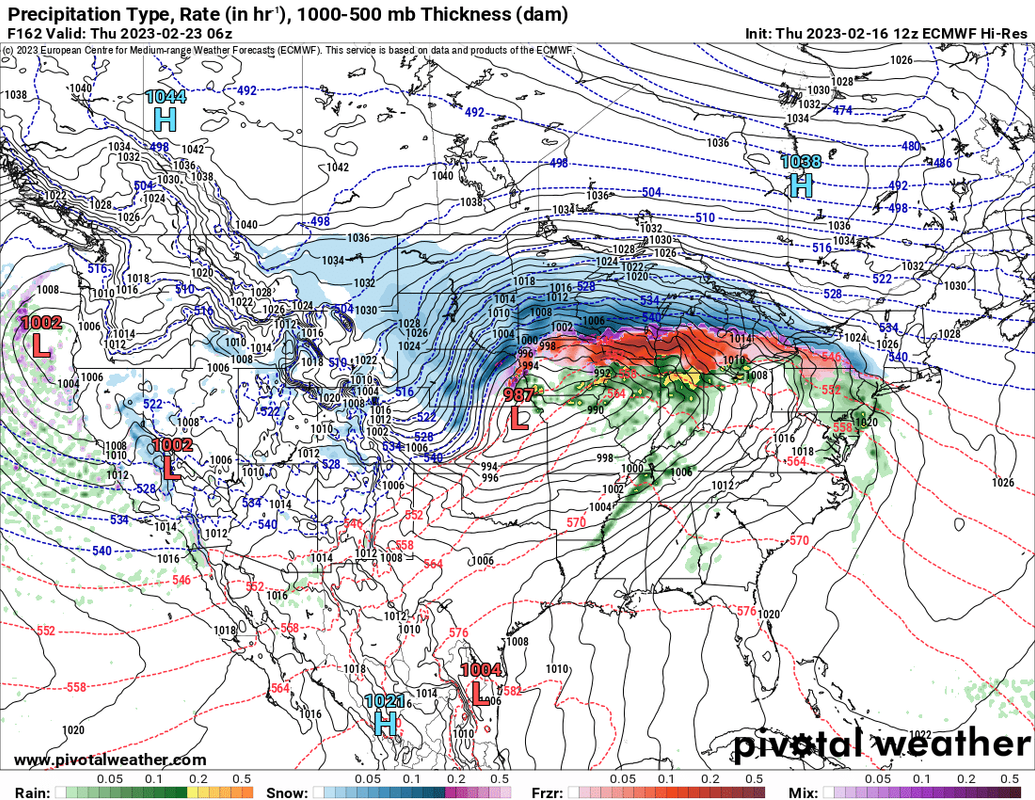
Both the 12z GFS and 12z ECMWF are showing what would be a LARGE blizzard next week (starting around Tuesday Feb 21st and lasting until Thursday February 23rd).
It's too far out like normal to be confident but IF this thing verifies as shown, it will be an absolute MONSTER for a significant portion of the country (right now it's "mostly" depicted for areas north of us but who knows at this point - either way it looks close enough it needs to be watched). It's very reminicent of the blizzard that impacted the Dakotas and western NE early this winter.
Something to keep a very close eye on at least.
For referecne, here is what I'm talking about. This image is based on n the 12z ECMWF for Wednesday evening - YIKES! Look how widespread the precip is and how close those isobars are over a huge area - nearly 1/3rd of the country
Both the 12z GFS and 12z ECMWF are showing what would be a LARGE blizzard next week (starting around Tuesday Feb 21st and lasting until Thursday February 23rd).
It's too far out like normal to be confident but IF this thing verifies as shown, it will be an absolute MONSTER for a significant portion of the country (right now it's "mostly" depicted for areas north of us but who knows at this point - either way it looks close enough it needs to be watched). It's very reminicent of the blizzard that impacted the Dakotas and western NE early this winter.
Something to keep a very close eye on at least.
For referecne, here is what I'm talking about. This image is based on n the 12z ECMWF for Wednesday evening - YIKES! Look how widespread the precip is and how close those isobars are over a huge area - nearly 1/3rd of the country
-
Brad
- Photographer
- Posts: 1036609
- Joined: Sun Feb 29, 2004 12:03 am
- Location: Omaha, NE
Re: 2023 Weather Thread
Oh wow. Mother nature trying to accomplish a full winter in a 1 week stretch...
Omaha Skyline Photos, Omaha Aerial Photos, and More.
Website: www.bradwilliamsphotography.com
Facebook: www.facebook.com/bradwilliamsphotography
Twitter: www.twitter.com/bradwphoto
Instagram: www.instagram.com/bradwilliamsphotography
YouTube: www.youtube.com/@bradwilliamsphoto
-
stormchaser
- Planning Board
- Posts: 2380
- Joined: Fri Jun 01, 2018 1:14 pm
Re: 2023 Weather Thread
Lol I just heard in the news officially 4 inches of snow in Omaha (based on Eppley report).
Umm, nope. Unless they got SIGNIFICANTLY less than everyone else, that’s ridiculous.
Umm, nope. Unless they got SIGNIFICANTLY less than everyone else, that’s ridiculous.
-
Louie
- County Board
- Posts: 4939
- Joined: Fri Dec 23, 2011 10:23 pm
- Location: Dundee
Re: 2023 Weather Thread
Yeah, that's way offstormchaser wrote: Thu Feb 16, 2023 11:32 pm Lol I just heard in the news officially 4 inches of snow in Omaha (based on Eppley report).
Umm, nope. Unless they got SIGNIFICANTLY less than everyone else, that’s ridiculous.
-
BRoss

- IT Director
- Posts: 10003397
- Joined: Sat Aug 05, 2006 12:39 am
- Location: West Central Omaha
Re: 2023 Weather Thread
Yeah, I got at least six inches with drifts reaching 10 or more.
-
Cermak
- Planning Board
- Posts: 2334
- Joined: Thu Nov 29, 2018 7:02 pm
Re: 2023 Weather Thread
I would say a good 8 inches in SW Omaha W. Center rd and I-680 . I think this is the most snow we have received since 2021, impressive storm. A nice light powdery snow as well.
-
Mr.Nuke
- Parks & Recreation
- Posts: 1219
- Joined: Wed May 09, 2007 3:12 am
- Location: Omaha
Re: 2023 Weather Thread
Totals based on reports to the NWS
You do not have the required permissions to view the files attached to this post.
-
GetUrban
- Planning Board
- Posts: 2648
- Joined: Sun Nov 23, 2008 9:07 pm
- Location: Omaha
Re: 2023 Weather Thread
Wow! The Reverse Omadome Effect! That one caught me by surprise. I thought it was going to be another bust, based on some forecasts were trending down with dry air coming in last night. Must have been a lot of moisture coming in at higher elevations. I thought the thunderstorms in Oklahoma had cut-off moisture coming our way.
He said "They are some big, ugly red brick buildings"
...and then they were gone.
...and then they were gone.
-
stormchaser
- Planning Board
- Posts: 2380
- Joined: Fri Jun 01, 2018 1:14 pm
Re: 2023 Weather Thread
I think a big part of what happened was a result of 3 main things:GetUrban wrote: Fri Feb 17, 2023 2:29 amWow! The Reverse Omadome Effect! That one caught me by surprise. I thought it was going to be another bust, based on some forecasts were trending down with dry air coming in last night. Must have been a lot of moisture coming in at higher elevations. I thought the thunderstorms in Oklahoma had cut-off moisture coming our way.
- Cold air moved in creating higher snow ratios despite the relatively dry air (hence the light/fluffy nature of the snow which accumulates quickly).
- The storm slowed down (it didn’t start until after midnight - several hours later than expected) and it snowed longer than anticipated.
- There was a shift further north than many models depicted. This put Omaha more in the band of heavier snow for a longer period of time.
-
SoPo
- New to the Neighborhood
- Posts: 17
- Joined: Sat Mar 17, 2018 11:28 pm
Re: 2023 Weather Thread
I understand the need to inform everyone of the possibility of an upcoming storm (so thank you for that), but isn't this just another example of what one would see on other websites/apps where someone posts the most extreme scenario, without showing some of the more moderate models?stormchaser wrote: Thu Feb 16, 2023 8:28 pm Now that this storm is basically done in our area anyway, it's time to look ahead.
Both the 12z GFS and 12z ECMWF are showing what would be a LARGE blizzard next week (starting around Tuesday Feb 21st and lasting until Thursday February 23rd).
It's too far out like normal to be confident but IF this thing verifies as shown, it will be an absolute MONSTER for a significant portion of the country (right now it's "mostly" depicted for areas north of us but who knows at this point - either way it looks close enough it needs to be watched). It's very reminicent of the blizzard that impacted the Dakotas and western NE early this winter.
Something to keep a very close eye on at least.
For referecne, here is what I'm talking about. This image is based on n the 12z ECMWF for Wednesday evening - YIKES! Look how widespread the precip is and how close those isobars are over a huge area - nearly 1/3rd of the country
-
Mr.Nuke
- Parks & Recreation
- Posts: 1219
- Joined: Wed May 09, 2007 3:12 am
- Location: Omaha
Re: 2023 Weather Thread
The strong winds from the North were always a forecast concern with this one as it virtually guaranteed a tight gradient on the Northern edge of the storm. The question was where was the Northern edge going to be. That is where the near term models struggled at this point last night going into this morning and ultimately came up short.GetUrban wrote: Fri Feb 17, 2023 2:29 am I thought it was going to be another bust, based on some forecasts were trending down with dry air coming in last night. Must have been a lot of moisture coming in at higher elevations. I thought the thunderstorms in Oklahoma had cut-off moisture coming our way.
Yeah I think these last two are basically the overriding factors. Models came around and indicated last night around this time that the storm was potentially slowing down. That was what was going to get us from the ~0-2" that the short-range models had been indicating yesterday to "covering" the forecast ~1-4."stormchaser wrote: Fri Feb 17, 2023 2:47 am - The storm slowed down (it didn’t start until after midnight - several hours later than expected) and it snowed longer than anticipated.
- There was a shift further north than many models depicted. This put Omaha more in the band of heavier snow for a longer period of time.
The bigger factor was #2. Other than the GFS every other model was off by 20-50 miles on the northern boundary and heaviest axis of snow. Yesterday there looked to be a sharp cutoff (and fairly good consensus among the high res models on where that would be) over Douglas County with Valley and Fremont getting virtually nothing and Southeastern Douglas County maybe getting 4 to 5." That actual gradient again ended up being about 20-40 miles further North, and this is primarily the reason why we ended up with more snow than expected. Like I said earlier it was really only the 11z (5 a.m. central) run that the HRRR caught up to where that actual Northern boundary was going to be.
Last edited by Mr.Nuke on Fri Feb 17, 2023 3:42 am, edited 2 times in total.
-
Mr.Nuke
- Parks & Recreation
- Posts: 1219
- Joined: Wed May 09, 2007 3:12 am
- Location: Omaha
Re: 2023 Weather Thread
No because what you are describing would be posting raw output of one run of one model and effectively saying this is what is going to happen next week. And that does happen, and yeah that is irresponsible. The post you quoted is fairly responsible in that 1) not giving raw model output from one run i.e. snow totals 2A) is backed up by multiple models. In this case the other longer range model the GFS backs the general idea of this storm as said post notes. 2B) to your moderate model there isn't one in this case which again should tell you something. The two go to long range models are both in general agreement of a massive storm somewhere in the high plains in that time frame 3) They notes that it is a too far out to know with certain and just to be aware.SoPo wrote: Fri Feb 17, 2023 2:54 am I understand the need to inform everyone of the possibility of an upcoming storm (so thank you for that), but isn't this just another example of what one would see on other websites/apps where someone posts the most extreme scenario, without showing some of the more moderate models?
A storm Tuesday to Thursday projected in South Dakota is close enough that I'm already casually watching it in Omaha to see what happens. This far out 100+ mile shifts are not uncommon. I myself typically won't get excited until 2-3 days out when the low pressure system nears the coast and we have a better idea of where it may go. With that said, what appears to be a massive storm hitting somewhere in the plains next week has my casual interest right now.
-
stormchaser
- Planning Board
- Posts: 2380
- Joined: Fri Jun 01, 2018 1:14 pm
Re: 2023 Weather Thread
Exactly - by no means am I saying this storm is going to happen - I’m simply informing of potential since it’s sub-200 hours out, etc. Odds are it will at the very least change some (to what extent nobody knows). That said it’s pretty uncommon for models to relatively agree on a storm of this magnitude in this timeframe. The difference is with my comments and those found in nonsense hype is this is being realistic with potential. Social media hype never stresses uncertainty, considers only worst case, etc. etc.Mr.Nuke wrote: Fri Feb 17, 2023 3:41 amNo because what you are describing would be posting raw output of one run of one model and effectively saying this is what is going to happen next week. And that does happen, and yeah that is irresponsible. The post you quoted is fairly responsible in that 1) not giving raw model output from one run i.e. snow totals 2A) is backed up by multiple models. In this case the other longer range model the GFS backs the general idea of this storm as said post notes. 2B) to your moderate model there isn't one in this case which again should tell you something. The two go to long range models are both in general agreement of a massive storm somewhere in the high plains in that time frame 3) They notes that it is a too far out to know with certain and just to be aware.SoPo wrote: Fri Feb 17, 2023 2:54 am I understand the need to inform everyone of the possibility of an upcoming storm (so thank you for that), but isn't this just another example of what one would see on other websites/apps where someone posts the most extreme scenario, without showing some of the more moderate models?
A storm Tuesday to Thursday projected in South Dakota is close enough that I'm already casually watching it in Omaha to see what happens. This far out 100+ mile shifts are not uncommon. I myself typically won't get excited until 2-3 days out when the low pressure system nears the coast and we have a better idea of where it may go. With that said, what appears to be a massive storm hitting somewhere in the plains next week has my casual interest right now.
-
SoPo
- New to the Neighborhood
- Posts: 17
- Joined: Sat Mar 17, 2018 11:28 pm
Re: 2023 Weather Thread
Please, don't get me wrong, I do appreciate what you do in using valid data. I guess my point is that I believe that I'm more appreciate of a "very responsible" post about an upcoming storm. Being "fairly responsible" doesn't really do it for me. But I do understand, that for greater accuracy, one would need to make forecasts 48-72 hours out. I guess in the future, I'll probably skip this thread because I don't want to read about highly fluid forecasts that are 200 hours out. When forecasting that far out, the chances of some reasonable accuracy are pretty much zero.Mr.Nuke wrote: Fri Feb 17, 2023 3:41 amThe post you quoted is fairly responsibleSoPo wrote: Fri Feb 17, 2023 2:54 am I understand the need to inform everyone of the possibility of an upcoming storm (so thank you for that), but isn't this just another example of what one would see on other websites/apps where someone posts the most extreme scenario, without showing some of the more moderate models?
With that being said, your efforts are greatly appreciated. When your forecasts take a bad turn (and that's happened to EVERY forecaster this season), you've owned up to it and continue to post what the forecast is trending to for the next week, and I admire people who aren't hesitant to go out on a limb. Thanks again.
-
stormchaser
- Planning Board
- Posts: 2380
- Joined: Fri Jun 01, 2018 1:14 pm
Re: 2023 Weather Thread
You’re obviously welcome to do as you please (I’m not here to convince otherwise though it’s a bit odd to post your intentions of not returning if I’m being honest). That being said, your statement suggesting near “zero accuracy” is 100% wrong and shows that you don’t really know what you’re talking about (no offense intended). I do appreciate your comments/kindness in your posts.SoPo wrote: Fri Feb 17, 2023 4:40 am I guess in the future, I'll probably skip this thread because I don't want to read about highly fluid forecasts that are 200 hours out. When forecasting that far out, the chances of some reasonable accuracy are pretty much zero.
The reason I made that post is because there is relatively good model agreement and run to run consistency with this potential storm system being well within 200 hours (or roughly 7 days - an approx “cut off” time in the forecasting world) - all of which increase the odds significantly of what’s being shown (though specifics like exact track, etc are impossible to know). I don’t just throw some random map up there and call it a forecast as it seems you maybe think (doing so would be reckless and isn’t forecasting). Can things change yet? Obviously. They can change no matter how close we are. Look at nearly all my long range posts on here. I stress they can change though when I post about a potential storm impacting the area, they typically happen more often than not.
Do we know the specifics yet for this storm? Obviously not but it’s reasonable to suggest a significant winter storm/potential blizzard will probably affect our region (or areas just north/west of us but it’s close) Tuesday-Thursday and it should be watched closely. Plain and simple.
If you think otherwise, that’s fine and if you don’t trust it, that’s fine too. I strongly suggest EVERYONE only listen to official forecast info from the NWS. But I think my track record here and ~20 years for forecasting/storm chasing speaks for itself. Does that mean I’m never wrong? Nope! My forecasts fail sometimes just like everyone else.
Anyhow, moving on now.
-
stormchaser
- Planning Board
- Posts: 2380
- Joined: Fri Jun 01, 2018 1:14 pm
Re: 2023 Weather Thread
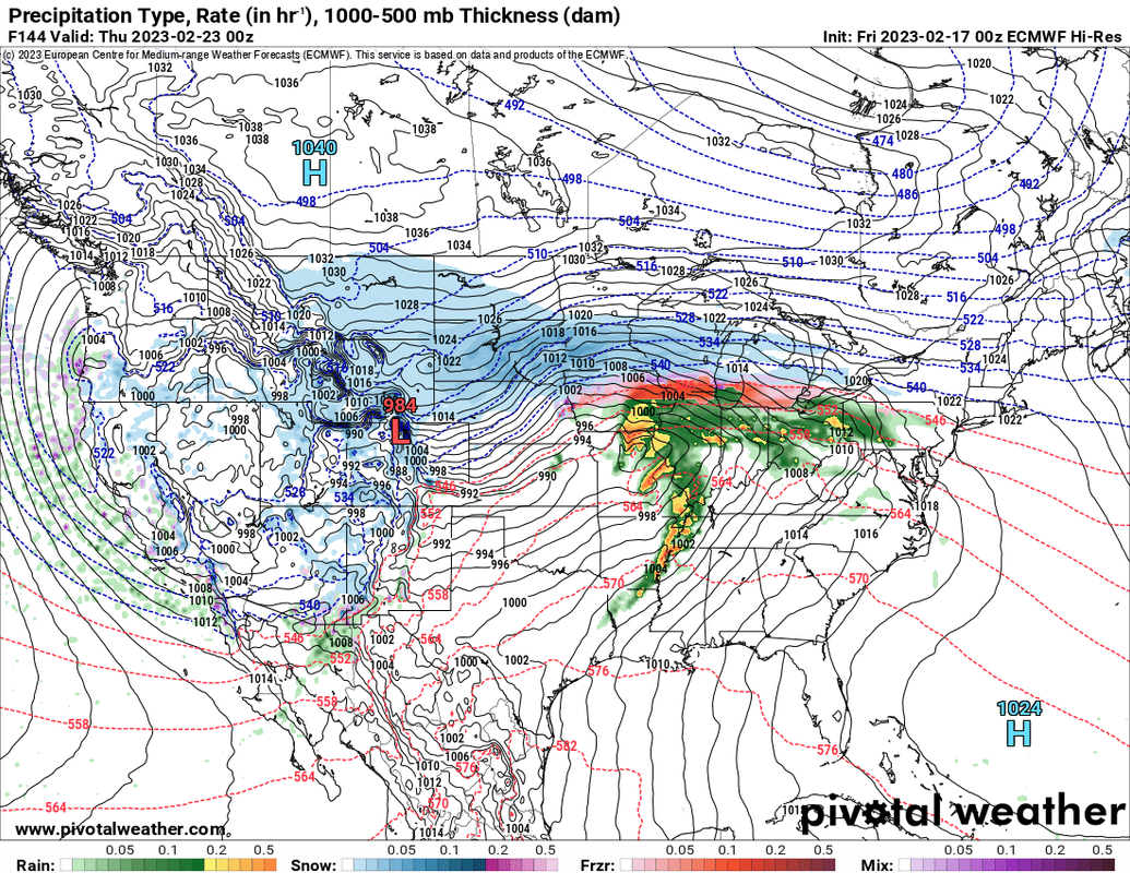
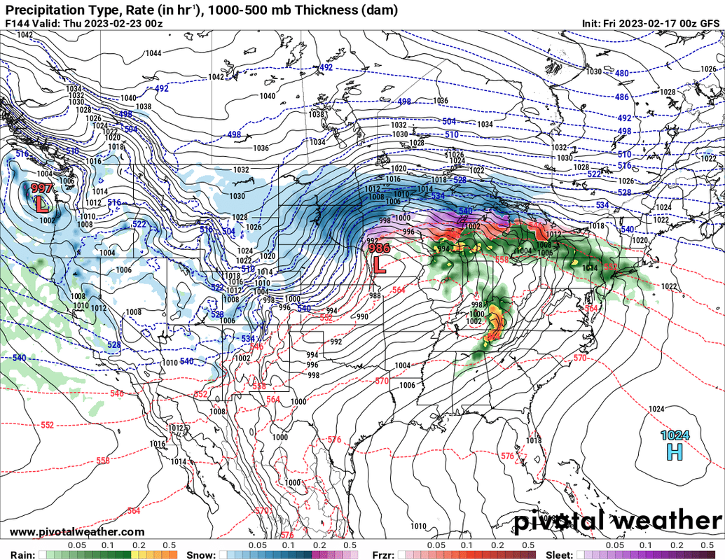
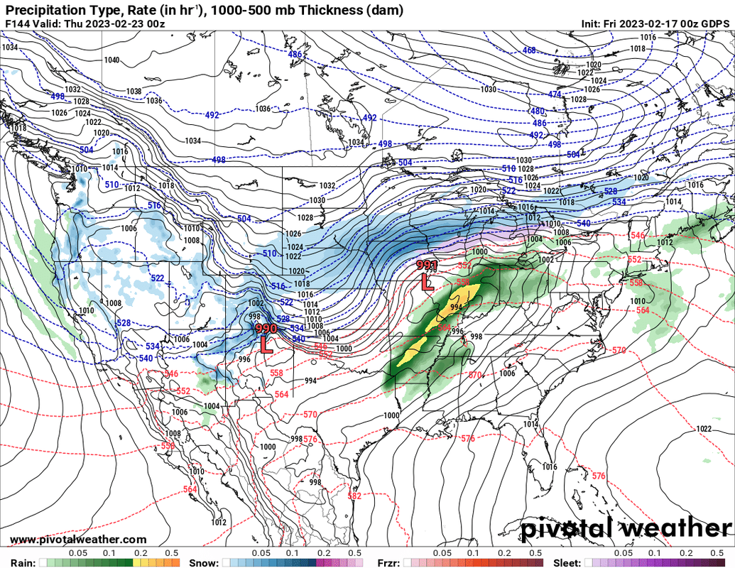
For reference just to show I'm not picking and choosing the "worst case" model output like people who "hype" typically do, below are the 3 main long range models. I chose to show the output from the ECMWF in my initial post above as it is typically considered to be the most reliable model of the 3 primary long range models (with the Canadian typically the least reliable).
In general, all are in good relative agreement with a signficant storm/potential blizzard occuring somewhere in our region. Obviously things can quickly change still but odds of this happening are about as high as they can be this far out.
All of these are from the 00z run last night (though the GFS has since updated to the 12z run already):
ECMWF:
GFS:
Canadian:
In general, all are in good relative agreement with a signficant storm/potential blizzard occuring somewhere in our region. Obviously things can quickly change still but odds of this happening are about as high as they can be this far out.
All of these are from the 00z run last night (though the GFS has since updated to the 12z run already):
ECMWF:
GFS:
Canadian:
-
Coyote

- City Council
- Posts: 34366
- Joined: Tue Nov 18, 2003 5:18 pm
- Yahoo Messenger: jestcoyote
- Location: Aksarben Village
Re: 2023 Weather Thread
Snowfall makes for dangerous commute, 'lighter' shoveling
Omaha residents were greeted with a thick blanket of snow Thursday. When’s the last time residents saw this much? That depends on who you ask. "It's been at least maybe four years," Stephen Vermaas said. "The last three years have been real light." "I think last year, we had snow that was probably fairly similar," Harmon Maher said.
-
damonhynes

- Parks & Recreation
- Posts: 1280
- Joined: Wed Aug 27, 2014 12:35 am
- Location: Montgomery County, Texas
Re: 2023 Weather Thread
Jeez, that looks grim for the Ohio River valley, tornado-wise. Not like anyone would be able to see anything, that is...
-
stormchaser
- Planning Board
- Posts: 2380
- Joined: Fri Jun 01, 2018 1:14 pm
Re: 2023 Weather Thread
Yeah, this year has been insane for tornadoes already and there is no reason to think it won't carry over into Spring. Who knows but if things continue as they have been, it's going to be pretty crazy this year.damonhynes wrote: Fri Feb 17, 2023 8:20 pm Jeez, that looks grim for the Ohio River valley, tornado-wise. Not like anyone would be able to see anything, that is...
-
nativeomahan

- County Board
- Posts: 6017
- Joined: Fri Nov 12, 2004 8:46 pm
- Location: Omaha and Puerto Vallarta
Re: 2023 Weather Thread
I listened to a Weather Channel podcast this morning, with predictions for the upcoming spring season (March 1 - May 31). From what I gather from the consensus of the 3 meteorologists who participated in the podcast, the northern and northwestern US can expect a cooler than average spring season, particularly March and April. The southern US and the eastern seaboard will be noticeably warmer than average. By May only the northwestern US will remain cooler than average. I did not listen to the full podcast so I missed any discussion of relative wet/dry patterns, other than that the Southwest would have a dry April and May.
-
Cermak
- Planning Board
- Posts: 2334
- Joined: Thu Nov 29, 2018 7:02 pm
Re: 2023 Weather Thread
Looks like a possible blizzard to the north of us (Sioux Fall area) this Wednesday, don't think Omaha is supposed to see much snow from this one.
-
stormchaser
- Planning Board
- Posts: 2380
- Joined: Fri Jun 01, 2018 1:14 pm
Re: 2023 Weather Thread
Yeah, that was the storm system I mentioned on Friday that looked like it was going to be a significant one. Thankfully it seems models are verifying and sparing the Omaha area for the most part.Cermak wrote: Mon Feb 20, 2023 4:50 am Looks like a possible blizzard to the north of us (Sioux Fall area) this Wednesday, don't think Omaha is supposed to see much snow from this one.
Parts of north and west Nebraska, most of South Dakota and much of Minnesota, a blizzard with heavy snow is fairly likely.
-
Brad
- Photographer
- Posts: 1036609
- Joined: Sun Feb 29, 2004 12:03 am
- Location: Omaha, NE
Re: 2023 Weather Thread
One of the models show the entire state of SD getting at least a foot, most of it a lot more. That's a lot of water to come down the Missouri River this spring...stormchaser wrote: Mon Feb 20, 2023 1:31 pm Parts of north and west Nebraska, most of South Dakota and much of Minnesota, a blizzard with heavy snow is fairly likely.
Omaha Skyline Photos, Omaha Aerial Photos, and More.
Website: www.bradwilliamsphotography.com
Facebook: www.facebook.com/bradwilliamsphotography
Twitter: www.twitter.com/bradwphoto
Instagram: www.instagram.com/bradwilliamsphotography
YouTube: www.youtube.com/@bradwilliamsphoto
-
stormchaser
- Planning Board
- Posts: 2380
- Joined: Fri Jun 01, 2018 1:14 pm
Re: 2023 Weather Thread
Yep, combine that with wind and it’s going to be no bueno for a lot of people.Brad wrote: Mon Feb 20, 2023 2:12 pmOne of the models show the entire state of SD getting at least a foot, most of it a lot more. That's a lot of water to come down the Missouri River this spring...stormchaser wrote: Mon Feb 20, 2023 1:31 pm Parts of north and west Nebraska, most of South Dakota and much of Minnesota, a blizzard with heavy snow is fairly likely.
Depending on how rapid the snow melts, certainly could be some serious flooding concerns too.
-
BRoss
- IT Director
- Posts: 10003397
- Joined: Sat Aug 05, 2006 12:39 am
- Location: West Central Omaha
Re: 2023 Weather Thread
I tried to find that and came across this article - https://weather.com/forecast/national/n ... tlook-2023nativeomahan wrote: Sun Feb 19, 2023 11:37 pm I listened to a Weather Channel podcast this morning, with predictions for the upcoming spring season (March 1 - May 31). From what I gather from the consensus of the 3 meteorologists who participated in the podcast, the northern and northwestern US can expect a cooler than average spring season, particularly March and April. The southern US and the eastern seaboard will be noticeably warmer than average. By May only the northwestern US will remain cooler than average. I did not listen to the full podcast so I missed any discussion of relative wet/dry patterns, other than that the Southwest would have a dry April and May.
I'm hoping it's not that below average

-
stormchaser
- Planning Board
- Posts: 2380
- Joined: Fri Jun 01, 2018 1:14 pm
Re: 2023 Weather Thread
For what it's worth, if the 12z models runs verify, Omaha could still get some accumulating snow with this upcoming storm system (mostly Wednesday night/Thursday).
Obviously the heavy stuff will miss us to the north but there "could" be at least a few inches of snow in our area yet before precip ends. Odds of this happening are currently low but it's something to watch.
Obviously the heavy stuff will miss us to the north but there "could" be at least a few inches of snow in our area yet before precip ends. Odds of this happening are currently low but it's something to watch.
-
Omaha Cowboy

- The Don
- Posts: 1013720
- Joined: Wed Jan 07, 2004 11:31 am
- Location: West Omaha
Re: 2023 Weather Thread
Bill Randby hinted we *could possibly* get 2 inches of snow out of this latest storm Wednesday night into Thursday..stormchaser wrote: Mon Feb 20, 2023 9:17 pm For what it's worth, if the 12z models runs verify, Omaha could still get some accumulating snow with this upcoming storm system (mostly Wednesday night/Thursday).
Obviously the heavy stuff will miss us to the north but there "could" be at least a few inches of snow in our area yet before precip ends. Odds of this happening are currently low but it's something to watch.
As always, I hope not…
Ciao..LiO…Peace
Go Cowboys!
-
stormchaser
- Planning Board
- Posts: 2380
- Joined: Fri Jun 01, 2018 1:14 pm
Re: 2023 Weather Thread
Yep, that’s a pretty realistic forecast for now anyway
-
Cermak
- Planning Board
- Posts: 2334
- Joined: Thu Nov 29, 2018 7:02 pm
Re: 2023 Weather Thread
Now they are talking historic blizzard for parts of southern and central Minnesota Wednesday, including the Twin Cities, South Dakota and western Wisconsin. It looks like the worst parts of the storm could be around the twin cities, 20+ inches. We are missing another one, I actually didn't mind the snow we had last week, most of its already melted.
-
stormchaser
- Planning Board
- Posts: 2380
- Joined: Fri Jun 01, 2018 1:14 pm
Re: 2023 Weather Thread
Yep - pretty much what I've been saying since Friday that someone mistook for hype when I was just trying to stress that this storm looked like it would probably be an absolute monster (probably a mistake on my part for not being more clear in my post). Oh well.Cermak wrote: Tue Feb 21, 2023 12:38 pm Now they are talking historic blizzard for parts of southern and central Minnesota Wednesday, including the Twin Cities, South Dakota and western Wisconsin. It looks like the worst parts of the storm could be around the twin cities, 20+ inches. We are missing another one, I actually didn't mind the snow we had last week, most of its already melted.
Looks like we may have some freezing rain issues (albeit not huge amounts of ice) with this one too tomorrow morning and then again after midnight tomorrow night. Enough that the roads may slicken up some.