Lol come on KETV, these are “gustnadoes” and 100% not a tornado.
This is the story on KETV with video that I’m referring to: https://www.ketv.com/article/video-nebr ... r/43820562
At times when there aren’t crops in the fields, "gustnadoes" really aren’t even that uncommon during severe weather as the dirt gets kicked up by the wind. I understand they may fool people who are untrained when they see them (tons are reported as tornadoes and cause false warnings as a result), but the Meteorologists at KETV should know better.
For reference, a “gustnado” typically poses very little risk (at least compared to most tornadoes) and are often found at the leading edge of outflow from a storm (which is why it looks like there are multiple circulations in the video with a precip core behind them). The wind associated with them is typically much weaker than tornadoes. Another key difference is there isn’t any rotation/funnel aloft so they aren’t actually connected to the storm in any way unlike tornadoes.
2023 Weather Thread
-
Louie
- County Board
- Posts: 4968
- Joined: Fri Dec 23, 2011 10:23 pm
- Location: Dundee
Re: 2023 Weather Thread
Anybody get rain totals last night?
-
stormchaser
- Planning Board
- Posts: 2380
- Joined: Fri Jun 01, 2018 1:14 pm
Re: 2023 Weather Thread
This site has them based on individual weather station reports anyway:
https://nednr.nebraska.gov/NeRain/Repor ... 2023-05-08
-
Brad

- Photographer
- Posts: 1036702
- Joined: Sun Feb 29, 2004 12:03 am
- Location: Omaha, NE
Re: 2023 Weather Thread
I haven't look at any official totals, but the 90th & Center area got a trace.

Omaha Skyline Photos, Omaha Aerial Photos, and More.
Website: www.bradwilliamsphotography.com
Facebook: www.facebook.com/bradwilliamsphotography
Twitter: www.twitter.com/bradwphoto
Instagram: www.instagram.com/bradwilliamsphotography
YouTube: www.youtube.com/@bradwilliamsphoto
-
skinzfan23
- City Council
- Posts: 11672
- Joined: Mon Feb 09, 2004 5:26 pm
- Location: Omaha/Bellevue
Re: 2023 Weather Thread
I believe most of the rain was all south of the Omaha metro, we did get .50in south of Bellevue.
-
Brad
- Photographer
- Posts: 1036702
- Joined: Sun Feb 29, 2004 12:03 am
- Location: Omaha, NE
Re: 2023 Weather Thread
Yeah, there was one cell heading towards Omaha when I was going to bed, but I'm assuming it fell apart. At least there are several rain chances this week.skinzfan23 wrote: Mon May 08, 2023 1:57 pm I believe most of the rain was all south of the Omaha metro, we did get .50in south of Bellevue.
Omaha Skyline Photos, Omaha Aerial Photos, and More.
Website: www.bradwilliamsphotography.com
Facebook: www.facebook.com/bradwilliamsphotography
Twitter: www.twitter.com/bradwphoto
Instagram: www.instagram.com/bradwilliamsphotography
YouTube: www.youtube.com/@bradwilliamsphoto
-
damonhynes

- Parks & Recreation
- Posts: 1282
- Joined: Wed Aug 27, 2014 12:35 am
- Location: Montgomery County, Texas
Re: 2023 Weather Thread
"Journalism". Reminds me of something I've seen during severe WX reporting over the past few years: Every tornado is a 'possible tornado'.stormchaser wrote: Mon May 08, 2023 3:34 am Lol come on KETV, these are “gustnadoes” and 100% not a tornado.
This is the story on KETV with video that I’m referring to: https://www.ketv.com/article/video-nebr ... r/43820562
At times when there aren’t crops in the fields, "gustnadoes" really aren’t even that uncommon during severe weather as the dirt gets kicked up by the wind. I understand they may fool people who are untrained when they see them (tons are reported as tornadoes and cause false warnings as a result), but the Meteorologists at KETV should know better.
For reference, a “gustnado” typically poses very little risk (at least compared to most tornadoes) and are often found at the leading edge of outflow from a storm (which is why it looks like there are multiple circulations in the video with a precip core behind them). The wind associated with them is typically much weaker than tornadoes. Another key difference is there isn’t any rotation/funnel aloft so they aren’t actually connected to the storm in any way unlike tornadoes.
Doesn't matter how clear the video is, no matter that debris is flying and power lines are shorting out, it's a 'possible tornado'. And what's the point? Who's going to sue them if it really was straight-line winds, or a dust devil?
-
stormchaser
- Planning Board
- Posts: 2380
- Joined: Fri Jun 01, 2018 1:14 pm
Re: 2023 Weather Thread
Yeah, it's just sad because next time this happens, these will be reported as tornadoes yet again (even though it's obvious they aren't) and more false warnings will occur as a result. The more false warnings that occur, the less and less likely people will actually pay attention to the warnings (many people ignore them already obviously) and ignoring the warnings is a bit like playing "Russian Roulette".damonhynes wrote: Mon May 08, 2023 2:07 pm "Journalism". Reminds me of something I've seen during severe WX reporting over the past few years: Every tornado is a 'possible tornado'.
Doesn't matter how clear the video is, no matter that debris is flying and power lines are shorting out, it's a 'possible tornado'. And what's the point? Who's going to sue them if it really was straight-line winds, or a dust devil?
KETV had a chance to do the right thing and use this video to help educate people and they apparently chose not to and went with the "possible tornado" theme instead. Of course there is a chance they put this video out there without showing it to one of their Meteorologists first, but I'd be surprised if thats the case.
-
stormchaser
- Planning Board
- Posts: 2380
- Joined: Fri Jun 01, 2018 1:14 pm
Re: 2023 Weather Thread
Our next severe weather threat will likely be this coming Thursday with a risk for fairly widespread damaging wind/hail event (and some tornado risk in central parts of NE).
The SPC currently has a "day 3" outlook for much of Nebraska (and parts of IA, etc):
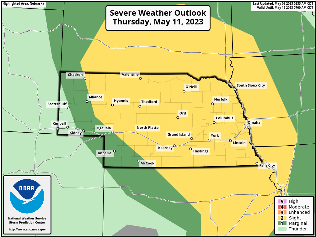
The SPC currently has a "day 3" outlook for much of Nebraska (and parts of IA, etc):
-
Brad
- Photographer
- Posts: 1036702
- Joined: Sun Feb 29, 2004 12:03 am
- Location: Omaha, NE
Re: 2023 Weather Thread
Quite the line of storms heading east along the Nebraska/Kansas border this morning.
Omaha Skyline Photos, Omaha Aerial Photos, and More.
Website: www.bradwilliamsphotography.com
Facebook: www.facebook.com/bradwilliamsphotography
Twitter: www.twitter.com/bradwphoto
Instagram: www.instagram.com/bradwilliamsphotography
YouTube: www.youtube.com/@bradwilliamsphoto
-
almighty_tuna
- City Council
- Posts: 106415
- Joined: Tue Apr 13, 2004 6:34 pm
- Location: Somewhere between downtown and Colorado
Re: 2023 Weather Thread
No kidding! I was surprised to see the tornado warnings for Franklin & Harlan counties on my Twitter feed this morning (@NWStornado)
-
stormchaser
- Planning Board
- Posts: 2380
- Joined: Fri Jun 01, 2018 1:14 pm
Re: 2023 Weather Thread
It's worth mentioning despite the fact the SPC currently has a "potential too low" (which is the lowest it can possibly go) currently for Friday (Day 4), IMO there is actually a decent chance for severe weather in parts of the area based on both the 12z GFS and 12z ECMWF.
I'm not sure what the SPC is seeing that would make them think there isn't at least some potential but I guess we will see...
I'm not sure what the SPC is seeing that would make them think there isn't at least some potential but I guess we will see...
-
stormchaser
- Planning Board
- Posts: 2380
- Joined: Fri Jun 01, 2018 1:14 pm
Re: 2023 Weather Thread
Here are the latest maps from the SPC for tomorrow and Friday (they added us to a slight risk for Friday which I wasn't surprised to see as that was something I mentioned last night I felt should happen). Also, even though we are in a slight risk for tomorrow, I'm not very confident that the severe weather will actually make it as far east as Omaha.
The threat on Friday looks "more" likely to impact our area (though it will depend on timing). Friday there appears to be at least some potential for all storm modes including supercells/tornadoes. It shouldn't be huge event but certainly could get bad in localized areas.
Thursday outlook (most should remain west of us):
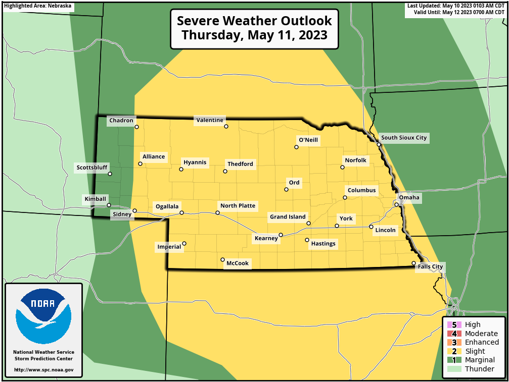
Friday outlook (probably our main risk day depending on timing):
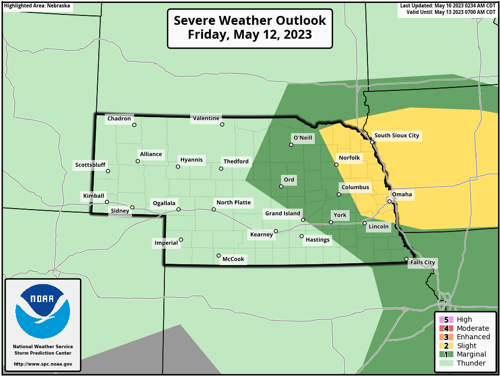
The threat on Friday looks "more" likely to impact our area (though it will depend on timing). Friday there appears to be at least some potential for all storm modes including supercells/tornadoes. It shouldn't be huge event but certainly could get bad in localized areas.
Thursday outlook (most should remain west of us):
Friday outlook (probably our main risk day depending on timing):
-
thenewguy
- County Board
- Posts: 4428
- Joined: Sat Oct 20, 2007 2:50 am
- Location: Council Bluffs
Re: 2023 Weather Thread
@stormchaser:
Overall, does this spring's cooler temps seem to be less conducive for severe weather in our area during tornado season? something like a long range winter forecast type thing? Seems like we should have had at least some bad storms by now, if we were going to have an active spring?
Overall, does this spring's cooler temps seem to be less conducive for severe weather in our area during tornado season? something like a long range winter forecast type thing? Seems like we should have had at least some bad storms by now, if we were going to have an active spring?
Go Cubs Go
-
stormchaser
- Planning Board
- Posts: 2380
- Joined: Fri Jun 01, 2018 1:14 pm
Re: 2023 Weather Thread
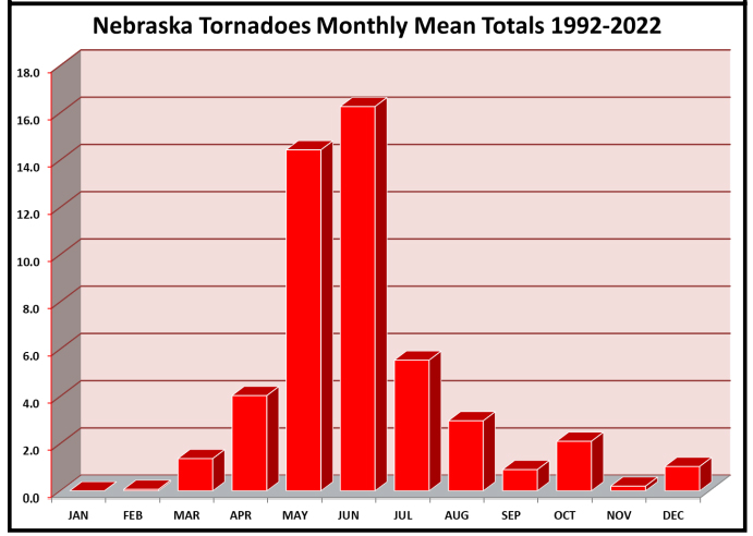
So far the cool start has slowed things some but we are just now really starting to hit peak tornado season so don't be surprised if things change and quickly get more active. Also, there has been a fair amount of tornadoes already just Omaha has managed to dodge the bullet with "most" of it occurring more into Iowa so far anyway.thenewguy wrote: Wed May 10, 2023 12:52 pm @stormchaser:
Overall, does this spring's cooler temps seem to be less conducive for severe weather in our area during tornado season? something like a long range winter forecast type thing? Seems like we should have had at least some bad storms by now, if we were going to have an active spring?
Tornadoes by month for Nebraska (since 1992 anyway):
-
Louie
- County Board
- Posts: 4968
- Joined: Fri Dec 23, 2011 10:23 pm
- Location: Dundee
Re: 2023 Weather Thread
Really interesting how the dryer and hotter air of July puts such a damper on tornadic systems.
-
stormchaser
- Planning Board
- Posts: 2380
- Joined: Fri Jun 01, 2018 1:14 pm
Re: 2023 Weather Thread
Yep, it's a result of it getting too hot aloft which is why as you get into July/August you get more night time storms (as the cap breaks as the temps aloft cool) and consequently you get more damaging wind/hail events than anything else...Louie wrote: Wed May 10, 2023 1:56 pm Really interesting how the dryer and hotter air of July puts such a damper on tornadic systems.
-
stormchaser
- Planning Board
- Posts: 2380
- Joined: Fri Jun 01, 2018 1:14 pm
Re: 2023 Weather Thread
Friday is looking increasingly like a legitimate chase day with a risk for tornadoes in the local area based on the 12z 3km NAM (which "may" be overdoing things some like depicted dewpoints but other models have started trending toward something more interesting as well). I wouldn't be surprised to see a bump up to an "enhanced" risk from the SPC if model trends continue.
The surface winds are a bit marginal still but there should be enough vorticity aloft to cause rotating updrafts/supercells. At the very least, a large hail threat will probably exist with at least a few tornadoes possible (where exactly will depend on the exact location of the low/dryline/warm front). My initial thoughts are areas of northeast NE and adjacent parts of IA - but possibly as far south as Omaha as well.
Something for people to keep a close eye on.
Until then, most storms (if we get any) will mostly be night time stuff.
The surface winds are a bit marginal still but there should be enough vorticity aloft to cause rotating updrafts/supercells. At the very least, a large hail threat will probably exist with at least a few tornadoes possible (where exactly will depend on the exact location of the low/dryline/warm front). My initial thoughts are areas of northeast NE and adjacent parts of IA - but possibly as far south as Omaha as well.
Something for people to keep a close eye on.
Until then, most storms (if we get any) will mostly be night time stuff.
-
skinzfan23
- City Council
- Posts: 11672
- Joined: Mon Feb 09, 2004 5:26 pm
- Location: Omaha/Bellevue
Re: 2023 Weather Thread
Thanks for the updates....headed out of town again this weekend. This time to the Amana Colonies, so I am keeping a close eye on the storms going across IA on I-80.
-
stormchaser
- Planning Board
- Posts: 2380
- Joined: Fri Jun 01, 2018 1:14 pm
Re: 2023 Weather Thread
No problem! Sounds like funskinzfan23 wrote: Wed May 10, 2023 5:54 pm Thanks for the updates....headed out of town again this weekend. This time to the Amana Colonies, so I am keeping a close eye on the storms going across IA on I-80.

-
stormchaser
- Planning Board
- Posts: 2380
- Joined: Fri Jun 01, 2018 1:14 pm
Re: 2023 Weather Thread
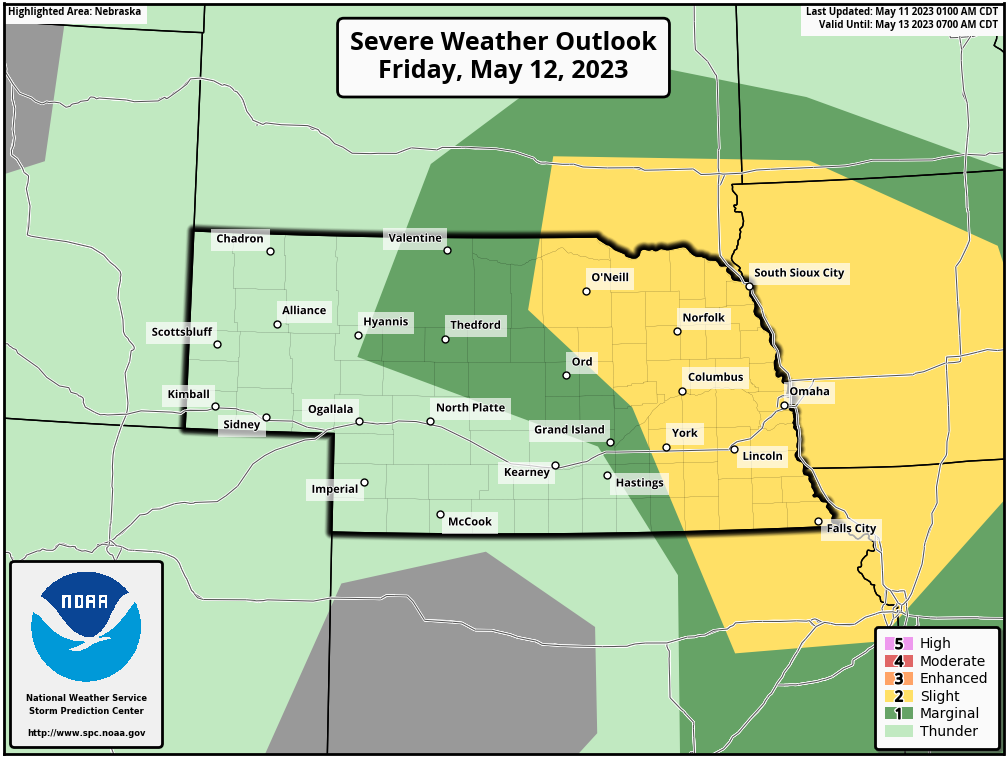
Updated SPC outlook for tomorrow. No upgrade to an "enhanced risk" at least not yet but not surprising, the same area as the "slight risk" is also in a 5% tornado risk as well.
-
stormchaser
- Planning Board
- Posts: 2380
- Joined: Fri Jun 01, 2018 1:14 pm
Re: 2023 Weather Thread
Based on the 12z HRRR, sometime between 4 PM and 8 PM tomorrow storms will impact Omaha and surrounding areas. My preliminary target is Nebraska City to Red Oak but it really just depends on where the boundary ends up. Certainly some supercell/tornado potential with storms as they move through the area - especially with anything that can remain discrete.
Here is a simulated radar from the 12z HRRR showing storms forming to our west around 4 PM and moving through within a few hours after that:
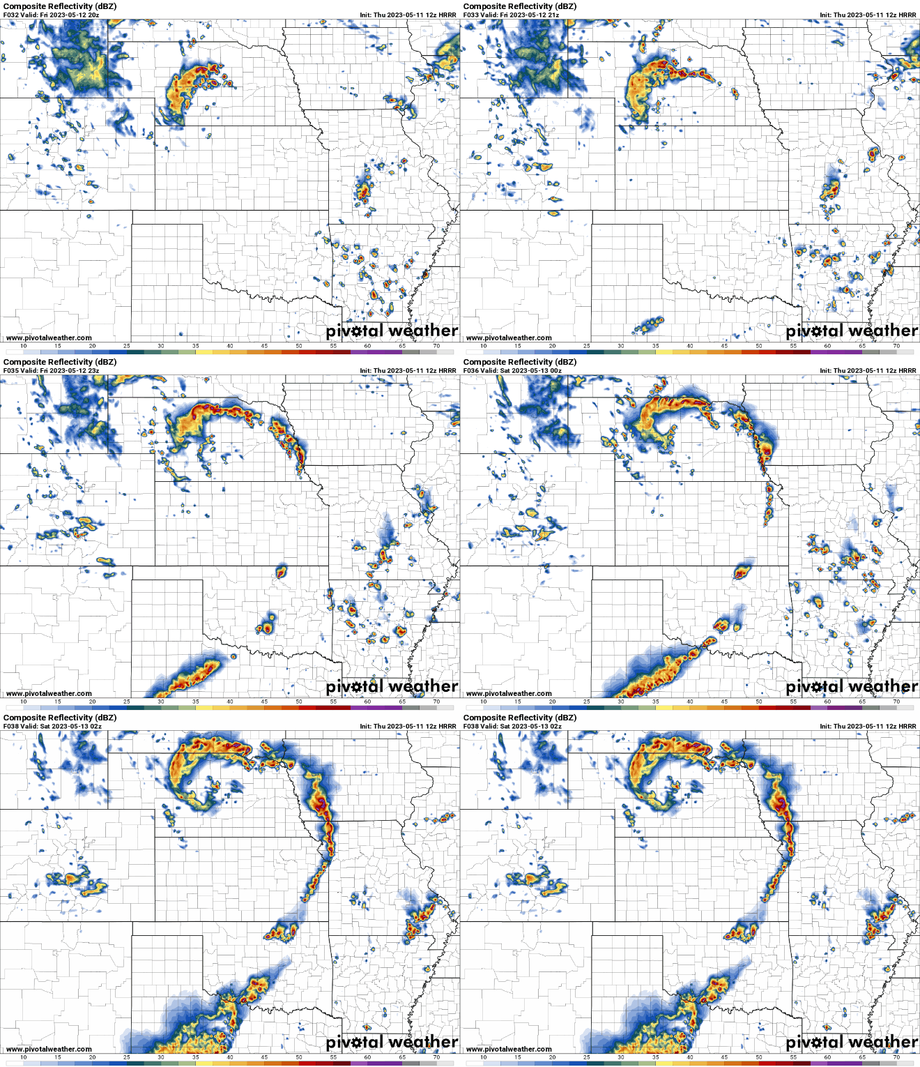
Here is a simulated radar from the 12z HRRR showing storms forming to our west around 4 PM and moving through within a few hours after that:
Last edited by stormchaser on Fri May 12, 2023 12:14 am, edited 1 time in total.
-
damonhynes
- Parks & Recreation
- Posts: 1282
- Joined: Wed Aug 27, 2014 12:35 am
- Location: Montgomery County, Texas
Re: 2023 Weather Thread
So, I can park at the Love's on I-29 @ Glenwood and catch two hoses. Kewl! :-)
-
stormchaser
- Planning Board
- Posts: 2380
- Joined: Fri Jun 01, 2018 1:14 pm
Re: 2023 Weather Thread
Lol yep! Maybe anywaydamonhynes wrote: Thu May 11, 2023 3:37 pm So, I can park at the Love's on I-29 @ Glenwood and catch two hoses. Kewl! :-)
-
thenewguy
- County Board
- Posts: 4428
- Joined: Sat Oct 20, 2007 2:50 am
- Location: Council Bluffs
-
stormchaser
- Planning Board
- Posts: 2380
- Joined: Fri Jun 01, 2018 1:14 pm
Re: 2023 Weather Thread
Probably nothing for severe stuff anyway - some on and off showers and “maybe” late night storms (but chances are low).
Tomorrow should be an active day in the area though.
-
Omaha Cowboy

- The Don
- Posts: 1013739
- Joined: Wed Jan 07, 2004 11:31 am
- Location: West Omaha
Re: 2023 Weather Thread
At least it’s raining a bit in my neck of the woods in west Omaha…stormchaser wrote: Fri May 12, 2023 12:13 amProbably nothing for severe stuff anyway - some on and off showers and “maybe” late night storms (but chances are low).
Tomorrow should be an active day in the area though.
Ciao..LiO…Peace
Go Cowboys!
-
stormchaser
- Planning Board
- Posts: 2380
- Joined: Fri Jun 01, 2018 1:14 pm
Re: 2023 Weather Thread
The 00z HRRR has trended towards potential for a more significant tornado event for eastern NE tomorrow afternoon - I wouldn’t rule out a strong tornado or 2 IF things verify as shown (which it may or may not - plenty of time for things to change yet). This includes Omaha itself (and surrounding areas) but odds are somewhat higher to our northwest from Fremont up toward Norfolk and surrounding areas of northeast NE.
Either way, people need to be ready tomorrow afternoon.
Simulated radar based on the 00z HRRR showing supercells in the area around 4 PM (though timing will probably change some):
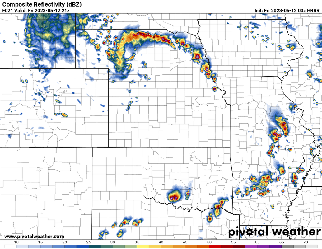
Either way, people need to be ready tomorrow afternoon.
Simulated radar based on the 00z HRRR showing supercells in the area around 4 PM (though timing will probably change some):
-
Louie
- County Board
- Posts: 4968
- Joined: Fri Dec 23, 2011 10:23 pm
- Location: Dundee
Re: 2023 Weather Thread
Well models show that we are getting a very nice rain event tonight.
-
stormchaser
- Planning Board
- Posts: 2380
- Joined: Fri Jun 01, 2018 1:14 pm
Re: 2023 Weather Thread
Not surprising after last nights model runs that the SPC has upgraded much of our area to an "enhanced risk". Still, the largest risk today is damaging wind and large hail. However, there will probably be tornadoes as well with at least some risk of a strong tornado or 2 somewhere in eastern NE - especially with anything that can remain discrete (that doesn't mean it'll happen but the potential is there).
It's also worth noting that since some of the storms will be scattered, not everyone in or near the risk area will see severe weather. Also, some of the severe weather in central/northern NE may get going later this morning already. The stuff for around Omaha probably won't develop until mid-afternoon though.
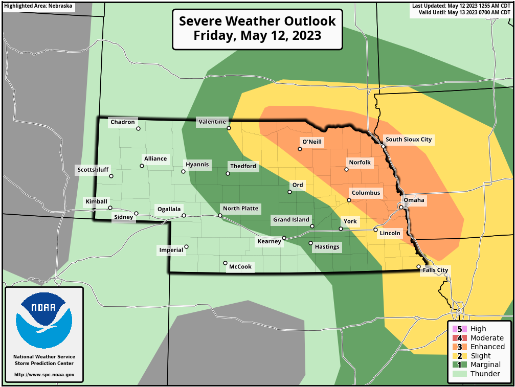
It's also worth noting that since some of the storms will be scattered, not everyone in or near the risk area will see severe weather. Also, some of the severe weather in central/northern NE may get going later this morning already. The stuff for around Omaha probably won't develop until mid-afternoon though.
-
stormchaser
- Planning Board
- Posts: 2380
- Joined: Fri Jun 01, 2018 1:14 pm
Re: 2023 Weather Thread
It isn't difficult to see where the center of the low pressure is this morning on visible satellite (southwest corner of NE) with lots of low level clouds east of the low (which isn't uncommon in the morning but these should quickly burn off).
The dryline is also easy to see already (currently in south central NE/north central KS just south/southwest of Hastings). This dryline feature is what will trigger our severe weather later this afternoon as it moves our direction.
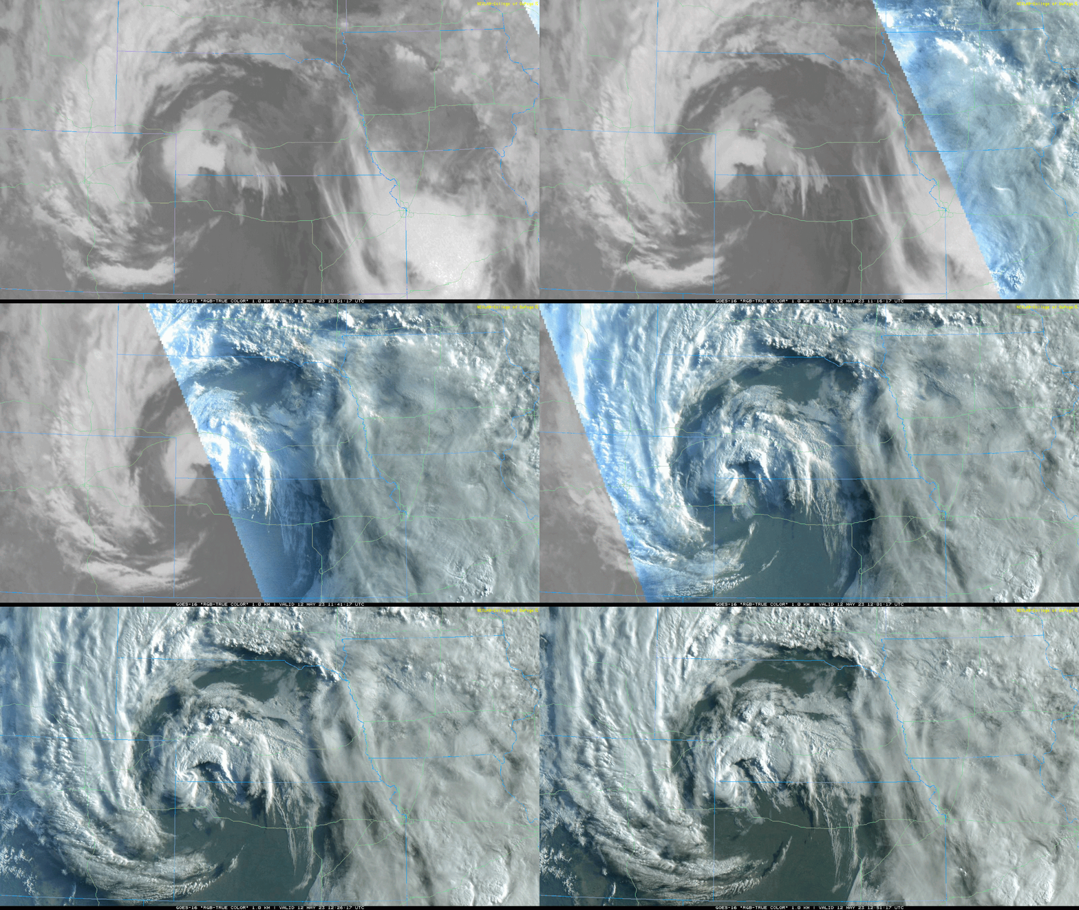
The dryline is also easy to see already (currently in south central NE/north central KS just south/southwest of Hastings). This dryline feature is what will trigger our severe weather later this afternoon as it moves our direction.
Last edited by stormchaser on Fri May 12, 2023 1:18 pm, edited 2 times in total.
-
Brad
- Photographer
- Posts: 1036702
- Joined: Sun Feb 29, 2004 12:03 am
- Location: Omaha, NE
Re: 2023 Weather Thread
I noticed we were in the 30% Hail Risk, with the hatch for significant hail. The summery also calls out Very Large Hail. We also have an east wind this morning which is never a good sign.
Hail Risk:SPC wrote:This should promote supercell storm structures capable of very large hail, damaging winds, and a few tornadoes.
You do not have the required permissions to view the files attached to this post.
Omaha Skyline Photos, Omaha Aerial Photos, and More.
Website: www.bradwilliamsphotography.com
Facebook: www.facebook.com/bradwilliamsphotography
Twitter: www.twitter.com/bradwphoto
Instagram: www.instagram.com/bradwilliamsphotography
YouTube: www.youtube.com/@bradwilliamsphoto
-
stormchaser
- Planning Board
- Posts: 2380
- Joined: Fri Jun 01, 2018 1:14 pm
Re: 2023 Weather Thread
Yeah, with these supercells, I wouldn't be shocked to see some baseball size hail in a few locations.Brad wrote: Fri May 12, 2023 1:07 pm I noticed we were in the 30% Hail Risk, with the hatch for significant hail. The summery also calls out Very Large Hail. We also have an east wind this morning which is never a good sign.
Hail Risk:SPC wrote:This should promote supercell storm structures capable of very large hail, damaging winds, and a few tornadoes.
hail.JPG
-
thenewguy
- County Board
- Posts: 4428
- Joined: Sat Oct 20, 2007 2:50 am
- Location: Council Bluffs
Re: 2023 Weather Thread
eductation time: why is east wind bad? Just that it's sucking air in towards the storms?
Go Cubs Go
-
stormchaser
- Planning Board
- Posts: 2380
- Joined: Fri Jun 01, 2018 1:14 pm
Re: 2023 Weather Thread
Yes, at least that's one of the reasons anyway.thenewguy wrote: Fri May 12, 2023 1:17 pm eductation time: why is east wind bad? Just that it's sucking air in towards the storms?
When it comes to supercells and especially tornadic storms, you need warm/moisture-rich inflow feeding into the storm. If this inflow comes from the east/southeast, then it's easier for that inflow to not get "undercut". When the inflow is "undercut", it basically means the outflow (aka rain cooled air coming from the storm or another nearby storm) has cut off the storms inflow of warm/moisture rich air. When this happens, these storms become what is known as an "outflow dominant" storm and are typically more damaging wind producers than anything because of it.
In addition, an easterly/southeasterly wind will also aide in veering winds with height (basically wind feeding into the storm from different directions as you go up in height which causes the storm to rotate) - AKA directional shear. This rotation is what leads to supercell development. The stronger directional shear you have at lower levels in the storm, the more likely it is to produce tornadoes - and sometimes strong tornadoes. This is why a strong low level jet is very important when it comes to tornadic development.
-
thenewguy
- County Board
- Posts: 4428
- Joined: Sat Oct 20, 2007 2:50 am
- Location: Council Bluffs
Re: 2023 Weather Thread
ugh that sucks. Is the hail threat going to be near glenwood this evening? Or is it more of a metro-proper threat? We have some business down that way this evening, and i'd rather not get caught in the bad stuff
Go Cubs Go
-
stormchaser
- Planning Board
- Posts: 2380
- Joined: Fri Jun 01, 2018 1:14 pm
Re: 2023 Weather Thread
Unfortunately, pretty much anywhere in eastern NE and western IA will be at risk. Since the storms will probably be at least somewhat scattered, it's impossible to know the exact locations that will be impacted...thenewguy wrote: Fri May 12, 2023 1:30 pm ugh that sucks. Is the hail threat going to be near glenwood this evening? Or is it more of a metro-proper threat? We have some business down that way this evening, and i'd rather not get caught in the bad stuff
-
stormchaser
- Planning Board
- Posts: 2380
- Joined: Fri Jun 01, 2018 1:14 pm
Re: 2023 Weather Thread
I'm still thinking I'll initially target Nebraska City and adjust from there...
-
thenewguy
- County Board
- Posts: 4428
- Joined: Sat Oct 20, 2007 2:50 am
- Location: Council Bluffs
-
stormchaser
- Planning Board
- Posts: 2380
- Joined: Fri Jun 01, 2018 1:14 pm
Re: 2023 Weather Thread
You're welcome!