2023 Weather Thread
-
stormchaser
- Planning Board
- Posts: 2380
- Joined: Fri Jun 01, 2018 1:14 pm
Re: 2023 Weather Thread
Southward moving outflow boundary is triggering storm development over Omaha…
-
stormchaser
- Planning Board
- Posts: 2380
- Joined: Fri Jun 01, 2018 1:14 pm
Re: 2023 Weather Thread
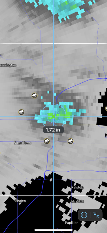
Probably over 1.5” of rain fell near Maple Street and 680 though some of this likely fell as hail (so the radar estimates may be at least somewhat too high).
-
stormchaser
- Planning Board
- Posts: 2380
- Joined: Fri Jun 01, 2018 1:14 pm
Re: 2023 Weather Thread
Big hail producer east of Omaha currently and if it maintains it strength (which it may or may not), parts of southern Omaha would be impacted.
-
stormchaser
- Planning Board
- Posts: 2380
- Joined: Fri Jun 01, 2018 1:14 pm
Re: 2023 Weather Thread
Looks like today and tomorrow will probably be relatively quiet for precip with highs expected to be around 90 (though there will be isolated popup type storms in the region this afternoon).
Then on Wednesday, a "backdoor cold front" (a cold front which is moving west) will move into our area from the east bring with it a chance for showers and thunderstorms - which again will be moving from our east to the west like they have been the last few days. This is the result of an "Omega blocking pattern".
Into this weekend (Saturday in particular), chances increase for another round of showers and thunderstorms - this time probably moving towards us from the north. This is depicted on forecast models as a more widespread precip event so hopefully it brings some decent rainfall across a larger portion of the area.
The Omega blocking pattern looks like it "might" finally break down early next week with what appears to be a return to a southwest flow after and consequently an increasing threat for severe weather in our area.
Obviously way too far out to be confident or to know specifics but we are quickly approaching our peak for tornado season and despite the fact things have been quiet as of late, they can QUICKLY change and it only takes one really bad storm. Just mentioning it because it's been easy to become complacent.
Then on Wednesday, a "backdoor cold front" (a cold front which is moving west) will move into our area from the east bring with it a chance for showers and thunderstorms - which again will be moving from our east to the west like they have been the last few days. This is the result of an "Omega blocking pattern".
Into this weekend (Saturday in particular), chances increase for another round of showers and thunderstorms - this time probably moving towards us from the north. This is depicted on forecast models as a more widespread precip event so hopefully it brings some decent rainfall across a larger portion of the area.
The Omega blocking pattern looks like it "might" finally break down early next week with what appears to be a return to a southwest flow after and consequently an increasing threat for severe weather in our area.
Obviously way too far out to be confident or to know specifics but we are quickly approaching our peak for tornado season and despite the fact things have been quiet as of late, they can QUICKLY change and it only takes one really bad storm. Just mentioning it because it's been easy to become complacent.
-
Brad

- Photographer
- Posts: 1036702
- Joined: Sun Feb 29, 2004 12:03 am
- Location: Omaha, NE
Re: 2023 Weather Thread
Sad thing is, they probably arn't that far off... LOL

Omaha Skyline Photos, Omaha Aerial Photos, and More.
Website: www.bradwilliamsphotography.com
Facebook: www.facebook.com/bradwilliamsphotography
Twitter: www.twitter.com/bradwphoto
Instagram: www.instagram.com/bradwilliamsphotography
YouTube: www.youtube.com/@bradwilliamsphoto
-
Omaha Cowboy

- The Don
- Posts: 1013736
- Joined: Wed Jan 07, 2004 11:31 am
- Location: West Omaha
Re: 2023 Weather Thread
Back that up to 5 years from last June, they’re likely spot on, LOL…
Ciao..LiO…Peace
Go Cowboys!
-
stormchaser
- Planning Board
- Posts: 2380
- Joined: Fri Jun 01, 2018 1:14 pm
Re: 2023 Weather Thread
Probably will be some strong to severe storms in parts of the area later today. Shouldn’t be anything widespread but some isolated stronger storms are fairly likely.
-
Brad
- Photographer
- Posts: 1036702
- Joined: Sun Feb 29, 2004 12:03 am
- Location: Omaha, NE
Re: 2023 Weather Thread
Went downtown tonight to try and catch a few lightning bolts but the storm fizzled out too quick...
Omaha Skyline Photos, Omaha Aerial Photos, and More.
Website: www.bradwilliamsphotography.com
Facebook: www.facebook.com/bradwilliamsphotography
Twitter: www.twitter.com/bradwphoto
Instagram: www.instagram.com/bradwilliamsphotography
YouTube: www.youtube.com/@bradwilliamsphoto
-
stormchaser
- Planning Board
- Posts: 2380
- Joined: Fri Jun 01, 2018 1:14 pm
Re: 2023 Weather Thread
Bummer - I've tried a few times in the past and haven't had a ton of luck with timing either (unfortunately).Brad wrote: Thu Jun 08, 2023 3:23 am Went downtown tonight to try and catch a few lightning bolts but the storm fizzled out too quick...
Looks like we are about to get some much needed rain in the Omaha area though here over the next few hours...hopefully anyway.
-
Louie
- County Board
- Posts: 4966
- Joined: Fri Dec 23, 2011 10:23 pm
- Location: Dundee
Re: 2023 Weather Thread
The OmaDome is putting up quite the fight against this slow moving rainstorm.
-
stormchaser
- Planning Board
- Posts: 2380
- Joined: Fri Jun 01, 2018 1:14 pm
Re: 2023 Weather Thread
Yeah, this first wave won't amount to much either way. There is another round moving south in northeast NE that should produce heavier rainfall later this afternoon in the area (assuming it holds together anyway).Louie wrote: Fri Jun 09, 2023 5:03 pm The OmaDome is putting up quite the fight against this slow moving rainstorm.
-
Louie
- County Board
- Posts: 4966
- Joined: Fri Dec 23, 2011 10:23 pm
- Location: Dundee
Re: 2023 Weather Thread
It looks like the second round is strengthening a bit. So I'm hopeful.stormchaser wrote: Fri Jun 09, 2023 5:11 pmYeah, this first wave won't amount to much either way. There is another round moving south in northeast NE that should produce heavier rainfall later this afternoon in the area (assuming it holds together anyway).Louie wrote: Fri Jun 09, 2023 5:03 pm The OmaDome is putting up quite the fight against this slow moving rainstorm.
-
stormchaser
- Planning Board
- Posts: 2380
- Joined: Fri Jun 01, 2018 1:14 pm
Re: 2023 Weather Thread
Unfortunately most of the precip moving in died out...but more stuff is developing to our northwest. We may still get some stuff later this afternoon and evening but our best chance will probably be late tonight (much of it probably after midnight) into early tomorrow morning.Louie wrote: Fri Jun 09, 2023 5:46 pmIt looks like the second round is strengthening a bit. So I'm hopeful.stormchaser wrote: Fri Jun 09, 2023 5:11 pmYeah, this first wave won't amount to much either way. There is another round moving south in northeast NE that should produce heavier rainfall later this afternoon in the area (assuming it holds together anyway).Louie wrote: Fri Jun 09, 2023 5:03 pm The OmaDome is putting up quite the fight against this slow moving rainstorm.
-
skinzfan23
- City Council
- Posts: 11670
- Joined: Mon Feb 09, 2004 5:26 pm
- Location: Omaha/Bellevue
Re: 2023 Weather Thread
Just yesterday wowt and KETV were both saying that the metro would almost certainly get rain with some spots as much as 1-2 in. Now I just checked and wowt is saying only some areas will see rain and maybe .5 in. I was really hoping we would get some rain.
-
stormchaser
- Planning Board
- Posts: 2380
- Joined: Fri Jun 01, 2018 1:14 pm
Re: 2023 Weather Thread
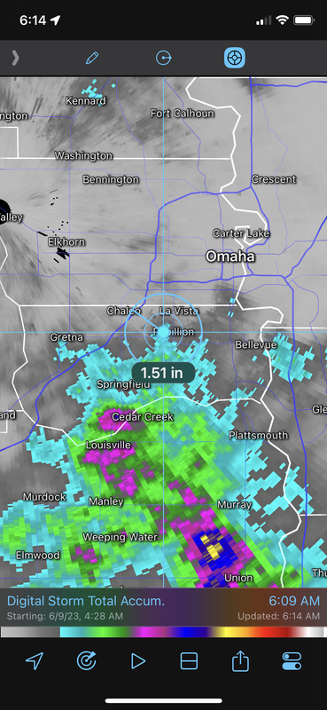
We BARELY missed the heavier rain which is unfortunate.skinzfan23 wrote: Sat Jun 10, 2023 11:21 pm Just yesterday wowt and KETV were both saying that the metro would almost certainly get rain with some spots as much as 1-2 in. Now I just checked and wowt is saying only some areas will see rain and maybe .5 in. I was really hoping we would get some rain.
Most of the metro ended up with a half inch (roughly) but far southern areas like Gretna, Papillion and Bellevue ended up with over an inch in most areas. Just south of that, many areas of 2-3”+ of rain.
Unfortunately timing was just slightly off this times and the heavier rain/storms developed on the south side and moved south.
Last edited by stormchaser on Sun Jun 11, 2023 11:57 am, edited 1 time in total.
-
nebugeater

- City Council
- Posts: 111063
- Joined: Wed Aug 04, 2004 11:07 pm
- Location: Gretna NE
Re: 2023 Weather Thread
Got 1.5 " overnight in Gretna on 6/10 - 6/11
For the record NEBUGEATER does not equal BUGEATER !!!!!!!
-
skinzfan23
- City Council
- Posts: 11670
- Joined: Mon Feb 09, 2004 5:26 pm
- Location: Omaha/Bellevue
Re: 2023 Weather Thread
Thankfully we ended up with 1.05 in south Bellevue.
-
stormchaser
- Planning Board
- Posts: 2380
- Joined: Fri Jun 01, 2018 1:14 pm
Re: 2023 Weather Thread
Should be some really pleasant weather in the area the next couple of days (especially for this time of year). Highs today should be around 80 with low dewpoints. Slightly warmer tomorrow but dewpoints should remain low.
Then our next round of potential for thunderstorms/severe weather increases toward the end of the week - probably late thursday night and again on Friday. Mostly damaging wind/hail threats though as a cold front pushes across the area on Friday.
Then our next round of potential for thunderstorms/severe weather increases toward the end of the week - probably late thursday night and again on Friday. Mostly damaging wind/hail threats though as a cold front pushes across the area on Friday.
-
Omaha Cowboy
- The Don
- Posts: 1013736
- Joined: Wed Jan 07, 2004 11:31 am
- Location: West Omaha
Re: 2023 Weather Thread
Thanks as always for the update..stormchaser wrote: Mon Jun 12, 2023 12:29 pm Should be some really pleasant weather in the area the next couple of days (especially for this time of year). Highs today should be around 80 with low dewpoints. Slightly warmer tomorrow but dewpoints should remain low.
Then our next round of potential for thunderstorms/severe weather increases toward the end of the week - probably late thursday night and again on Friday. Mostly damaging wind/hail threats though as a cold front pushes across the area on Friday.
It appears to be a pleasant, relatively quiet weather week.. I wouldn’t mind more rain though…
Ciao..LiO…Peace
Go Cowboys!
-
stormchaser
- Planning Board
- Posts: 2380
- Joined: Fri Jun 01, 2018 1:14 pm
Re: 2023 Weather Thread
No problem! Yep, the first half of the week anyway 
-
Busguy2010

- City Council
- Posts: 7393
- Joined: Sun Apr 10, 2011 12:32 am
- Location: North Central Omaha
Re: 2023 Weather Thread
We haven't had a good old fashioned CWS "Welcome to Omaha" storm in quite a while. I honestly don't remember the last big storm we had during the CWS.
It used to be nearly every year you could count on it. And here about halfway through our most active month, it kind of feels like the window is closing.
It used to be nearly every year you could count on it. And here about halfway through our most active month, it kind of feels like the window is closing.
-
stormchaser
- Planning Board
- Posts: 2380
- Joined: Fri Jun 01, 2018 1:14 pm
Re: 2023 Weather Thread
Maybe this yearBusguy2010 wrote: Tue Jun 13, 2023 3:55 pm We haven't had a good old fashioned CWS "Welcome to Omaha" storm in quite a while. I honestly don't remember the last big storm we had during the CWS.
It used to be nearly every year you could count on it. And here about halfway through our most active month, it kind of feels like the window is closing.
. And yeah, the last several weeks have been ridiculously quiet (partly because a rapidly strengthening El Nino weather pattern). We will still get severe weather/tornadoes for several months yet but the main risks will quickly start transitioning to night time damaging wind events.-
Omaha Cowboy
- The Don
- Posts: 1013736
- Joined: Wed Jan 07, 2004 11:31 am
- Location: West Omaha
Re: 2023 Weather Thread
Bill Randby was stating this evening, the Omaha area has a 40% chance of Thunderstorms Friday through Sunday..not all day washouts, but at least decent thunderstorm chances..
Here’s to hoping we at least get some rain out of this…
Ciao..LiO…Peace
Here’s to hoping we at least get some rain out of this…
Ciao..LiO…Peace
Go Cowboys!
-
stormchaser
- Planning Board
- Posts: 2380
- Joined: Fri Jun 01, 2018 1:14 pm
Re: 2023 Weather Thread
Hopefully anyway. As of this morning at least both the GFS and ECMWF are showing our best chance for precip on Saturday with most everything else remaining west of here most days (unfortunately). Who knows though. The 00z NAM shows Friday having a decent chance for precip too (and probably Saturday though it isn't in range yet). It all just depends exactly when pieces of energy are ejected out of the Rockies toward our direction in the next few days. Either way, most of what does occur will be pretty scattered.Omaha Cowboy wrote: Wed Jun 14, 2023 2:58 am Bill Randby was stating this evening, the Omaha area has a 40% chance of Thunderstorms Friday through Sunday..not all day washouts, but at least decent thunderstorm chances..
Here’s to hoping we at least get some rain out of this…
Ciao..LiO…Peace
-
nebugeater
- City Council
- Posts: 111063
- Joined: Wed Aug 04, 2004 11:07 pm
- Location: Gretna NE
Re: 2023 Weather Thread
IT is CWS so there will be rain. That is OK though, Need it bad
For the record NEBUGEATER does not equal BUGEATER !!!!!!!
-
stormchaser
- Planning Board
- Posts: 2380
- Joined: Fri Jun 01, 2018 1:14 pm
Re: 2023 Weather Thread
Oh I'm sure, it's just a matter of exactly when and to what extentnebugeater wrote: Wed Jun 14, 2023 12:42 pm IT is CWS so there will be rain. That is OK though, Need it bad
-
nativeomahan

- County Board
- Posts: 6026
- Joined: Fri Nov 12, 2004 8:46 pm
- Location: Omaha and Puerto Vallarta
Re: 2023 Weather Thread
Just a ton of smoke has rolled across our skies this afternoon. Definitely blocking out some of the rays of the sun, everything is just a pale gray in an otherwise cloudless sky.
-
stormchaser
- Planning Board
- Posts: 2380
- Joined: Fri Jun 01, 2018 1:14 pm
Re: 2023 Weather Thread
Yep, thankfully we aren't further north in MN where they have air quality alerts.nativeomahan wrote: Wed Jun 14, 2023 9:12 pm Just a ton of smoke has rolled across our skies this afternoon. Definitely blocking out some of the rays of the sun, everything is just a pale gray in an otherwise cloudless sky.
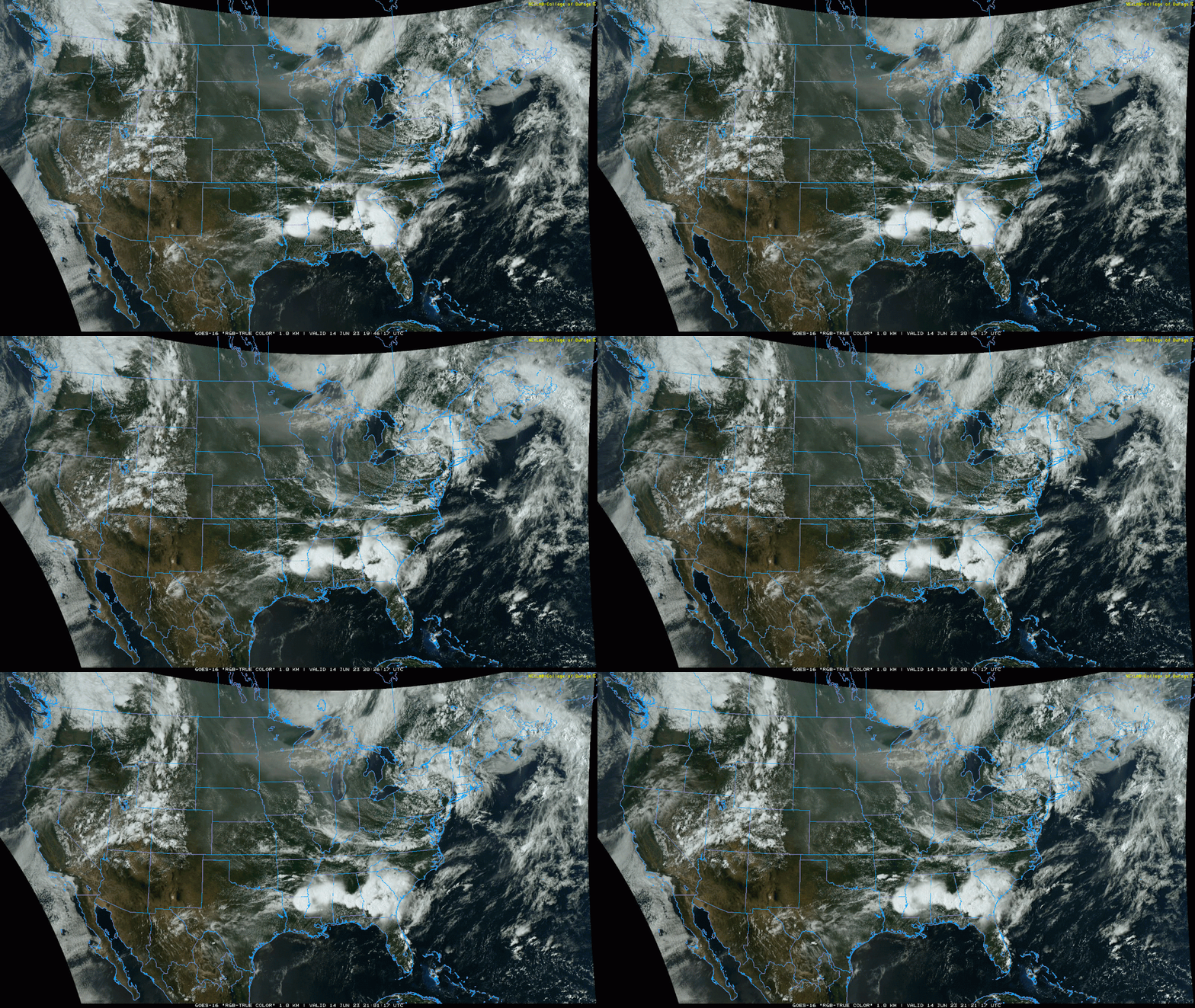
Pretty easy to see the smoke coming out of Canada on visible satellite (with the thicker stuff up to our north):
-
ChadJK
- Planning Board
- Posts: 2538
- Joined: Tue Feb 19, 2019 8:51 pm
Re: 2023 Weather Thread
I wonder how air quality would affect the CWS if too much Canadian smoke poured into our neck of the woods.
-
stormchaser
- Planning Board
- Posts: 2380
- Joined: Fri Jun 01, 2018 1:14 pm
Re: 2023 Weather Thread
Yeah, that would be interesting. I'm assuming they'd postpone games depending on how bad it got.ChadJK wrote: Wed Jun 14, 2023 10:21 pm I wonder how air quality would affect the CWS if too much Canadian smoke poured into our neck of the woods.
-
stormchaser
- Planning Board
- Posts: 2380
- Joined: Fri Jun 01, 2018 1:14 pm
Re: 2023 Weather Thread
I wouldn't be surprised if there are a few scattered strong/severe storms in the area Friday night and again on Saturday based on model trends (though if it happens, it would probably be a fairly localized threat). Otherwise, "hopefully" some much needed rain with our best chance on Saturday.
-
stormchaser
- Planning Board
- Posts: 2380
- Joined: Fri Jun 01, 2018 1:14 pm
Re: 2023 Weather Thread
Not looking very likely we will get much of any precip today. Terrible timing so everything moving in from the west has died out and redevelopment may not occur until the forcing is north and east of here this afternoon (depending on timing).
Hopefully things redevelop soon though. If it does, then we will have a chance. If it’s this afternoon, probably no chance.
Hopefully things redevelop soon though. If it does, then we will have a chance. If it’s this afternoon, probably no chance.
-
stormchaser
- Planning Board
- Posts: 2380
- Joined: Fri Jun 01, 2018 1:14 pm
Re: 2023 Weather Thread
Then again, strong storm developing on the north side of Omaha.
Unfortunately most of Omaha is still going to get missed probably…
Unfortunately most of Omaha is still going to get missed probably…
-
stormchaser
- Planning Board
- Posts: 2380
- Joined: Fri Jun 01, 2018 1:14 pm
Re: 2023 Weather Thread
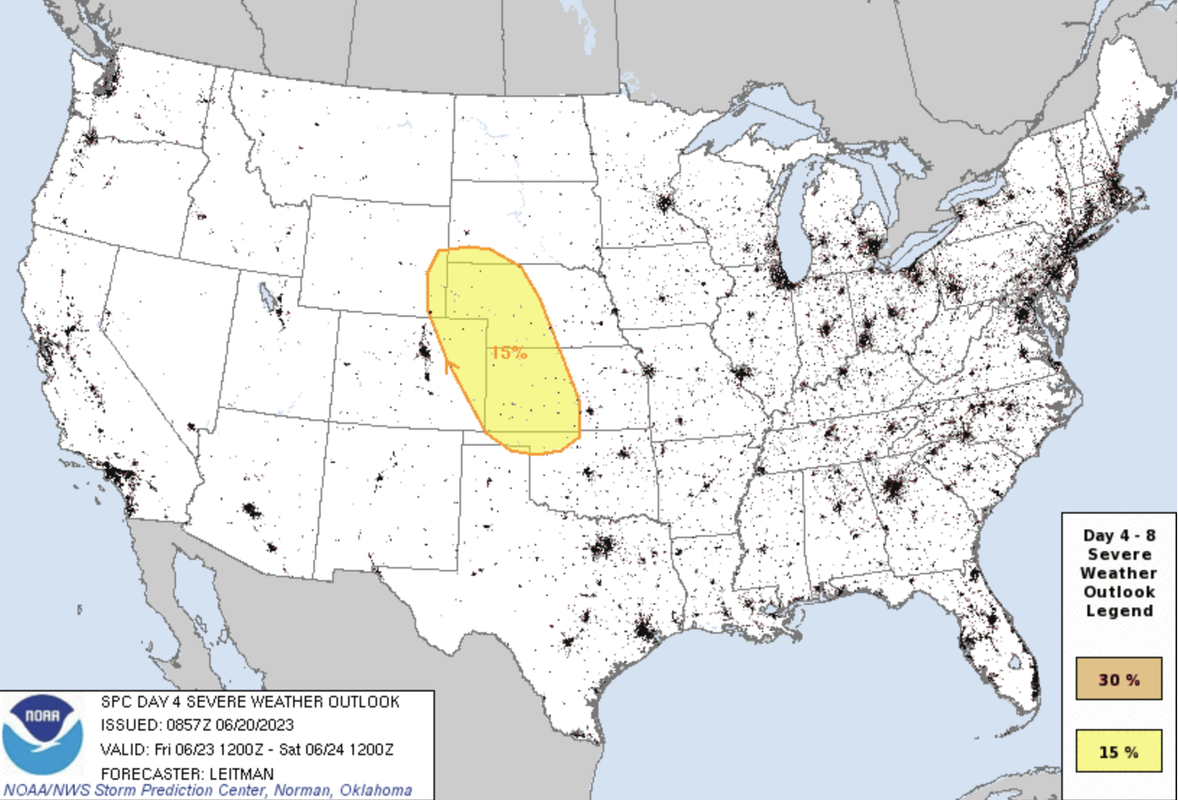
The potential for strong/severe storms increases again this coming Friday and Saturday (June 23rd and 24th).
The SPC currently has a day 4 and day 5 outlook for parts of Nebraska (day 5 - Saturday, includes Omaha). However, my initial impression based on the 00z GFS and ECMWF is that severe weather will occur in parts of western/central Nebraska Friday/Friday night and then die out as things move east (before getting to Omaha) and then redevelop on Saturday east of Omaha in parts Iowa.
This scenario of storms to our west that die out before they get here and then redevelop to our east the next day has seemed to happen more times than I can count the last few years and obviously won't help with the drought if it happens again. It's too far out to really "know" this scenario is likely to happen though so obviously don't let down your guard and keep an eye on things in the coming days.
All storm modes will be possible both days including the potential for tornadoes - especially near the area of low pressure (which right now looks to pass north of here on Saturday but it's too far out to know). Otherwise the primary risks will probably be damaging wind/hail along a cold front that will move across much of the area.
Day 4 (Friday) outlook:
Day 5 (Saturday) outlook:
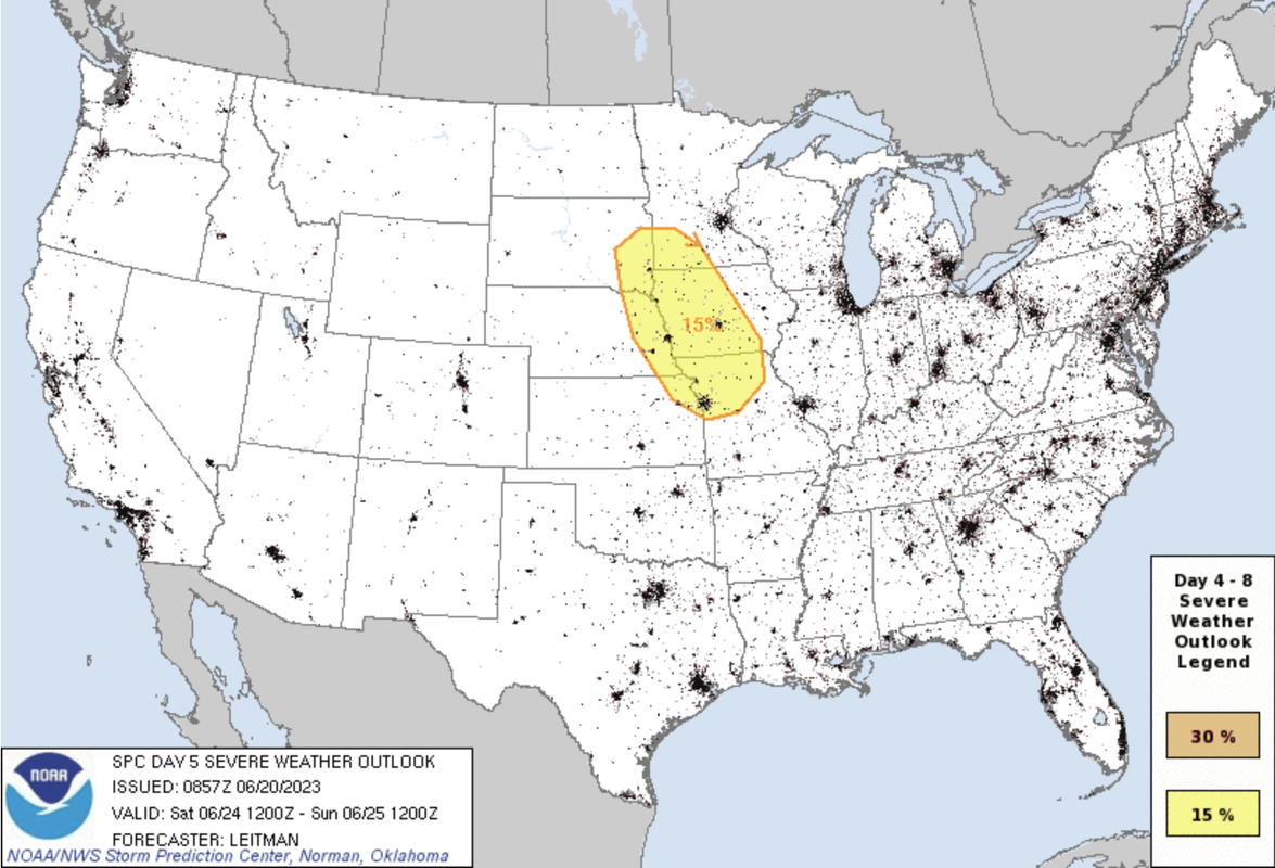
The SPC currently has a day 4 and day 5 outlook for parts of Nebraska (day 5 - Saturday, includes Omaha). However, my initial impression based on the 00z GFS and ECMWF is that severe weather will occur in parts of western/central Nebraska Friday/Friday night and then die out as things move east (before getting to Omaha) and then redevelop on Saturday east of Omaha in parts Iowa.
This scenario of storms to our west that die out before they get here and then redevelop to our east the next day has seemed to happen more times than I can count the last few years and obviously won't help with the drought if it happens again. It's too far out to really "know" this scenario is likely to happen though so obviously don't let down your guard and keep an eye on things in the coming days.
All storm modes will be possible both days including the potential for tornadoes - especially near the area of low pressure (which right now looks to pass north of here on Saturday but it's too far out to know). Otherwise the primary risks will probably be damaging wind/hail along a cold front that will move across much of the area.
Day 4 (Friday) outlook:
Day 5 (Saturday) outlook:
-
Omaha Cowboy
- The Don
- Posts: 1013736
- Joined: Wed Jan 07, 2004 11:31 am
- Location: West Omaha
Re: 2023 Weather Thread
I know it’s only been a day, but has the needle moved regarding the severe threat for the Omaha area this Saturday?…
Ciao..LiO…Peace
Ciao..LiO…Peace
Go Cowboys!
-
Brad
- Photographer
- Posts: 1036702
- Joined: Sun Feb 29, 2004 12:03 am
- Location: Omaha, NE
Re: 2023 Weather Thread
The SPC outlook for Saturday still like the image posted above.Omaha Cowboy wrote: Wed Jun 21, 2023 1:14 pm I know it’s only been a day, but has the needle moved regarding the severe threat for the Omaha area this Saturday?…
Omaha Skyline Photos, Omaha Aerial Photos, and More.
Website: www.bradwilliamsphotography.com
Facebook: www.facebook.com/bradwilliamsphotography
Twitter: www.twitter.com/bradwphoto
Instagram: www.instagram.com/bradwilliamsphotography
YouTube: www.youtube.com/@bradwilliamsphoto
-
stormchaser
- Planning Board
- Posts: 2380
- Joined: Fri Jun 01, 2018 1:14 pm
Re: 2023 Weather Thread
Odds have increased some on recent model runs for Omaha to get hit on Saturday (possibly late Friday night too but that risk still looks west of us currently) but ultimately it's going to depend on timing that the cold front pushes through our area.Omaha Cowboy wrote: Wed Jun 21, 2023 1:14 pm I know it’s only been a day, but has the needle moved regarding the severe threat for the Omaha area this Saturday?…
Ciao..LiO…Peace
On the latest ECMWF, It shows storm development in the late afternoon near or just east of Omaha though the storms look somewhat scattered or at least as more of a MCS. It isn't uncommon for models to trend slower/further west as we get closer but who knows if that will happen this time.
-
stormchaser
- Planning Board
- Posts: 2380
- Joined: Fri Jun 01, 2018 1:14 pm
Re: 2023 Weather Thread
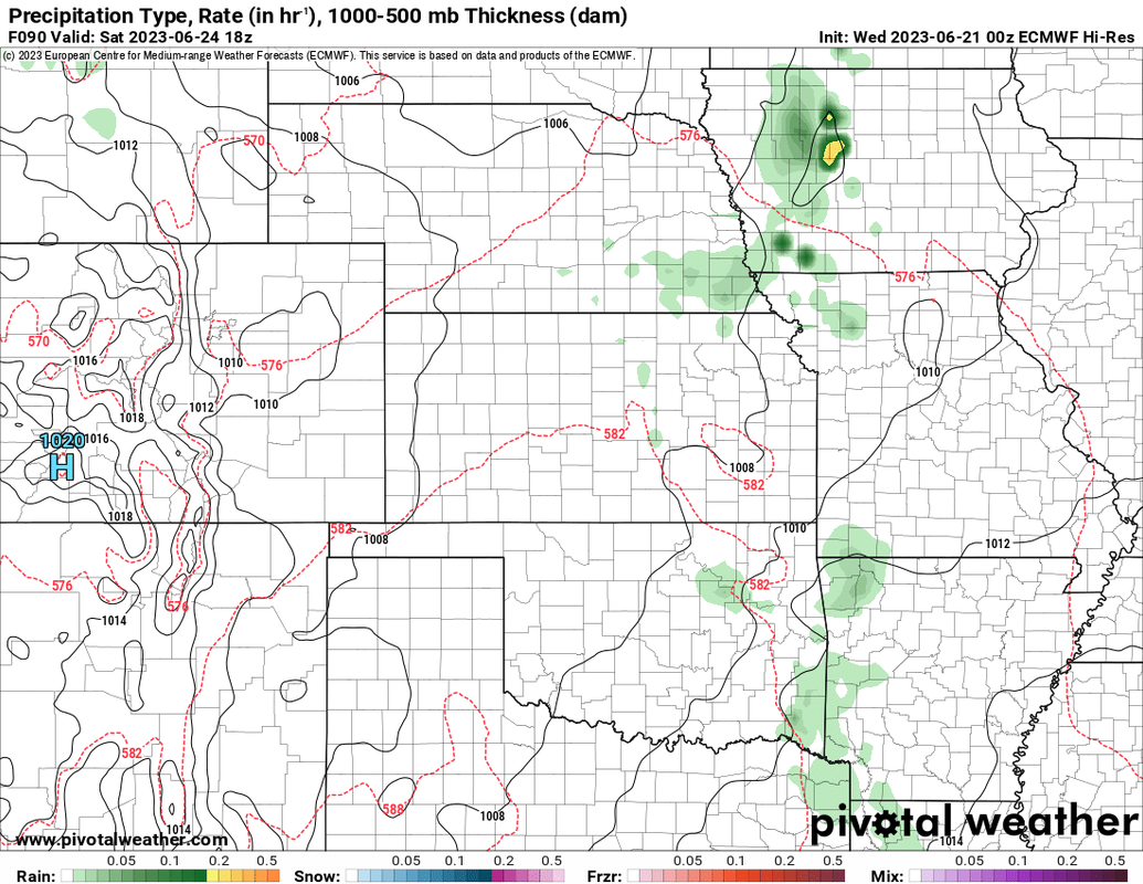
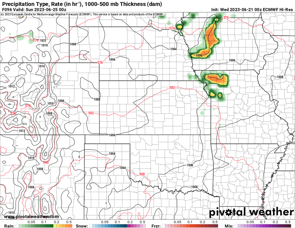
The below images show a simulated radar from the 00z ECMWF. The first image is for Noon on Saturday. The second is for 6 PM.
Since this is a long range model and there are 6 hours between images, it's difficult to really have an idea of when/where storms are most likely to develop based on this model anyway (until higher-res medium/short range models are in range to see).
It very well "could" be in time to impact Omaha though...
Noon Saturday:
6 PM Saturday:
Since this is a long range model and there are 6 hours between images, it's difficult to really have an idea of when/where storms are most likely to develop based on this model anyway (until higher-res medium/short range models are in range to see).
It very well "could" be in time to impact Omaha though...
Noon Saturday:
6 PM Saturday:
-
Omaha Cowboy
- The Don
- Posts: 1013736
- Joined: Wed Jan 07, 2004 11:31 am
- Location: West Omaha
Re: 2023 Weather Thread
Thanks for the feedback- I’m sure as we roll into late Thursday/early Friday we’ll have an even better read…
Ciao..LiO…Peace
Ciao..LiO…Peace
Go Cowboys!
-
stormchaser
- Planning Board
- Posts: 2380
- Joined: Fri Jun 01, 2018 1:14 pm
Re: 2023 Weather Thread
No problem!Omaha Cowboy wrote: Wed Jun 21, 2023 1:55 pm Thanks for the feedback- I’m sure as we roll into late Thursday/early Friday we’ll have an even better read…
Ciao..LiO…Peace
Latest update from the SPC is more in-line with what I'm thinking where Omaha/far eastern NE will be on the edge of the severe weather threat on Saturday with storm redevelopment occurring in the area and then tracking east into Iowa.
Exact timing will be key if Omaha itself is impacted or not (unless things change yet which they obviously still can).