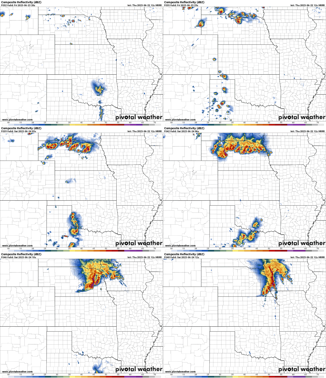
Short range models are starting to pick up on things now and show potential for a damaging wind event in the Omaha area during the overnight Friday night into early Saturday (as well as a more widespread severe weather event in parts of NE Friday evening).
However, just to clarify most of Saturday itself won't be in range yet on short range models until this evening (though additional severe weather will be "possible" in our area depending on timing that the cold front pushes through). That being said, if the late night damaging wind event does occur Friday overnight, I'd expect this will push the risk on Saturday more into Iowa - but I'm just speculating based on previous forecasting experience.
Of course this is one single run of one single model so take it with a grain of salt "for now" anyway but it wouldn't surprise me at all if our area is added to a severe weather risk area for tomorrow night - especially if other models start picking up more on this potential and/or if run to run consistency is observed later today.
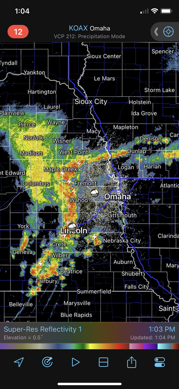
Below is the simulated radar from the 12z HRRR. It shows a line of storms likely producing damaging wind moving into the Omaha area after 4 AM Friday overnight/Saturday morning.
Models are almost all in good agreement with the potential for a damaging wind event occurring tomorrow night during the overnight hours into early Saturday in much of eastern Nebraska/western Iowa (including Omaha).
In addition to damaging wind, hail will also be a threat (though the primary threat will probably be the damaging wind potential in our area if storms maintain their strength - with a higher risk to the west of Omaha).
On the plus side, after the late Friday night/early Saturday storms come through, redevelopment of storms/severe weather Saturday afternoon will likely occur east of here into Iowa.
Still some timing differences between forecast models but it will probably be after midnight for our area anyway. Most models show the threat sometime between 3 AM and 6 AM here but exact timing is always tough to forecast with these types of storms as they can quickly speed up as they start to "bow out" and the threat for damaging wind increases - so it very well could be earlier than that.
Long story short, I wouldn't go to bed tomorrow night without making sure things are secure first.
Omaha Cowboy wrote: Wed Jun 21, 2023 1:55 pm
Thanks for the feedback- I’m sure as we roll into late Thursday/early Friday we’ll have an even better read…
Ciao..LiO…Peace
No problem!
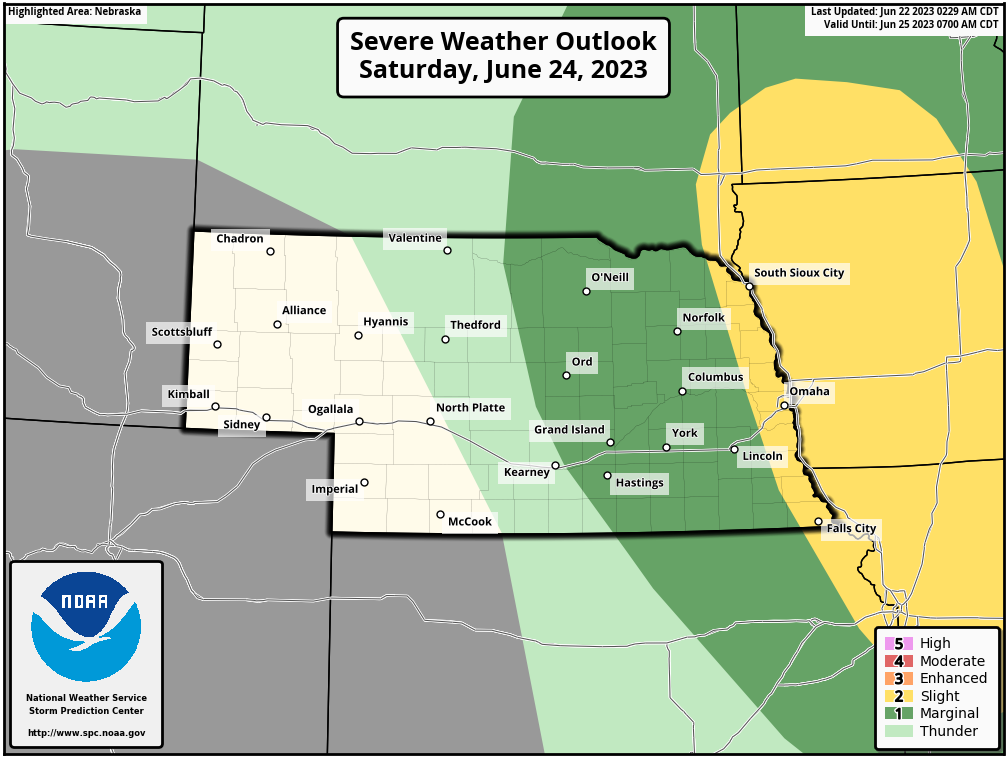
Latest update from the SPC is more in-line with what I'm thinking where Omaha/far eastern NE will be on the edge of the severe weather threat on Saturday with storm redevelopment occurring in the area and then tracking east into Iowa.
Exact timing will be key if Omaha itself is impacted or not (unless things change yet which they obviously still can).
I appreciate this as always..
Looks like things may be brewing on the strong to severe side of things. Of course, I’d just like a soaking rain event …
Still looking like our main chance for strong/severe storms will be late tonight/early tomorrow morning (probably between 4 AM and 7 AM). Not as much of a damaging wind threat as it looked before but I'm sure there will be some severe warned storms in the region anyway for wind and hail.
Hopefully we will get some decent rainfall totals in the area at least.
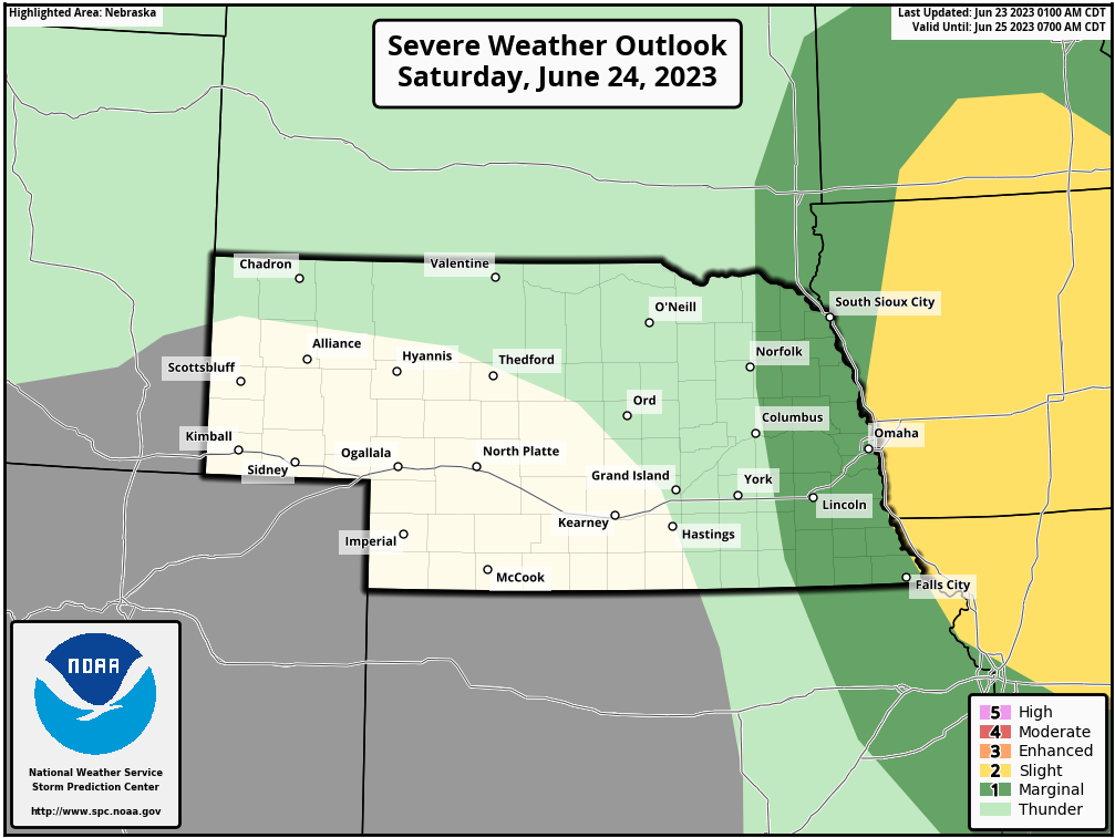
Redevelopment on Saturday still looks mostly into Iowa and the SPC has shifted the threat further east and no longer includes Omaha (barely but still):
thenewguy wrote: Fri Jun 23, 2023 1:13 pm
rain good, hail bad. We have a family reunion Saturday in Missouri east of St. Joe, and would love to not get beat up by it.
Even though that area is technically in the risk area for tomorrow, IMO anyway the risk that far south is relatively low as most of it will probably be capped (If anyone is interested, I wrote up an explanation of what a cap is in last year's weather thread here: https://www.eomahaforums.com/viewtopic. ... ap#p352453).
The overnight/early morning storms "might" even pass north of Omaha (at least the main stuff) as they will be riding along the northern edge of capping/ridging so it ultimately will depend how warm it gets aloft in our area if we are impacted or just grazed.
The same will be true on Saturday. The further south you are, the warmer temps will be aloft and the more capped the atmosphere will probably be.
Along the northern edge of this capping (probably somewhere between Omaha and Des Moines) will be where storm redevelopment happens Saturday afternoon and where at least some tornado potential will exist and as they track east more into central IA.
I'm not saying to not keep an eye on things in St. Joe, but I think your odds of getting a storm are relatively low. If anything develops, it will probably be very scattered in that area.
I was out in Scottsbluff last Friday for a gravel bike race and we got absolutely slammed by storms. So much so they ended up canceling the race on Saturday due to tornados and hail damage. While it was nice to see a good storm finally, the amount of damage was terrible to see for that local community.
ShawJ wrote: Thu Jun 29, 2023 11:30 am
A lot of rain coming in. If we don’t get any from this we are truly cursed.
Yep, finally. Hopefully more too the next several days.
I saw overnight last night some places in southern NE saw 70+ mph winds and baseball size hail causing busted out windows on their homes, downed trees, etc. Unfortunately some pretty significant sounding damaging in some areas.
Cermak wrote: Thu Jun 29, 2023 12:40 pm
Most significant rain in probably close to a month.
Between 7am and 8am I got 0.56" at my house, That's a good start with another shot tomorrow.
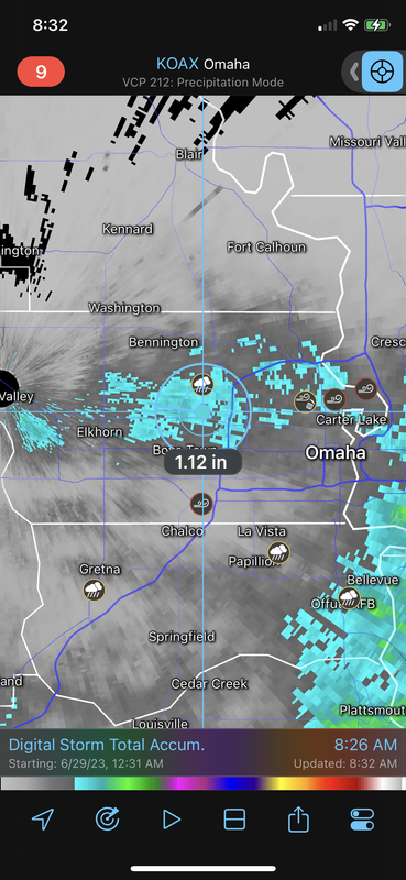
Unfortunately, I only ended up with .28” at my house in Millard. Places along and north of Dodge and then along and east of the Missouri had the heaviest rain totals with radar estimates over an inch with scattered wind damage/branches down (nothing too large that I’ve seen though).
Here are radar rainfall estimates. The blue areas are over 1”, dark grey is over .5”:
Last edited by stormchaser on Thu Jun 29, 2023 1:41 pm, edited 1 time in total.
I work near google by 370, and it absolutely poured. I don't know at all what the rain total was, but for 20-30 minutes, it rained incredibly hard and was windy. Hopefully we get some Friday/Saturday, too
I slept through most of it, though I did hear a couple rumbles of thunder. I'm assuming it wasn't great where I am since I didn't hear any significantly heavy rain on the roof.
stormchaser wrote: Thu Jun 29, 2023 1:35 pm
Here are radar rainfall estimates. The blue areas are over 1”, dark grey is over .5”:
I don't think the radar estimates were very good today. One person I talked to this morning said they radar estimate was nearly double what the real rain gauge said.
stormchaser wrote: Thu Jun 29, 2023 1:35 pm
Here are radar rainfall estimates. The blue areas are over 1”, dark grey is over .5”:
I don't think the radar estimates were very good today. One person I talked to this morning said they radar estimate was nearly double what the real rain gauge said.
Yeah, certainly possible. Hopefully we will get a decent amount again late tonight/early tomorrow (looks like we will but we will see)
Thunderstorms moved across the metro Thursday morning that provided some much needed rain. Following the driest May on record, the Omaha area is still struggling to recover. The latest drought conditions as of Thursday, June 29th show Omaha currently sits at severe to exceptional drought. The area would need about seven additional inches of precipitation to fully recover from the present drought conditions.
damonhynes wrote: Fri Jun 30, 2023 2:34 pm
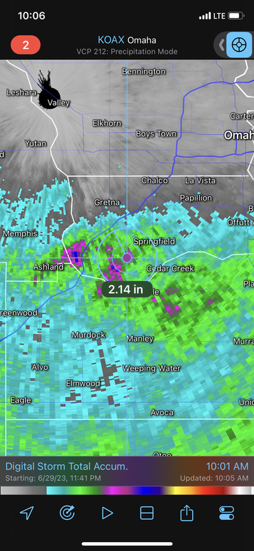
Lord Rusty said 2" for Springfield, I have my doubts. Would be glad to be proven wrong, though.
Based on radar estimates, that’s probably pretty close (in/around there at least - anything in pink is 2”+…more than that even in some localized areas with a few areas over 2.5”).
Brad wrote: Fri Jun 30, 2023 1:43 pm
Another 0.53" today, that along with the 0.62" yesterday puts my me at 1.15" for the 2 day total. Near 90th and Center.
Really good timing with people blowing up their neighborhoods this weekend...
I got another 1.10" so my 2 day total is 2.25", crazy to think that is 5 times more than the whole month of May.
Both these storms have been misses for me. Had to be south of Dodge to see the real benefit. I heard almost nonstop thunder from about 2-5 I think it was, but it really didn't rain a significant amount on the north side of town. The outlook for today split Douglas County in half lengthwise between the marginal and slight risk. They were spot on with that.
Now this has been beautiful! A nice widespread soaking rain that the whole metro can say they received! Love it. Now if only we can get this twice a week until freezing temps come.
This is strange. I was working and the power went out in Central Omaha, went home in North Central and all the streetlights I went through were out, came home to no power as well, and I live over two miles from work. Checked and pretty much all of Central Omaha is in the blue on OPPD. And I keep hearing explosions. I pray they aren't transformers blowing up because it's been a lot. Sure it could be fireworks, but I don't see even the most dedicated pyromaniacs trying that in this rain. Very strange.




 …