Good point. On one of the news stations they interviewed a farmer who said the dry soil is down to 4 feet in his field. Of course that varies depending on the elevation and type of soil, but it’s going to take a while to recharge the subsurface conditions.Busguy2010 wrote: Sat Jul 08, 2023 3:16 amI dunno, welcome rain for sure, I dont remember the quote verbatum, but "we have to have well above average moisture for a good six months in order to get back to 'x'".Cermak wrote: Sat Jul 08, 2023 1:13 am Seems like we should be making a dent in the drought with these rains , I got an inch at my house today, at least it's not bone dry anymore.
I'll be looking where we're at at the end of the month.
2023 Weather Thread
-
GetUrban
- Planning Board
- Posts: 2650
- Joined: Sun Nov 23, 2008 9:07 pm
- Location: Omaha
Re: 2023 Weather Thread
He said "They are some big, ugly red brick buildings"
...and then they were gone.
...and then they were gone.
-
Omaha Cowboy

- The Don
- Posts: 1013737
- Joined: Wed Jan 07, 2004 11:31 am
- Location: West Omaha
Re: 2023 Weather Thread
Lawn just freshly mowed this morning..
I’ll say this, the rain we’ e gotten the past 10 or so days has saved many lawns in my neighborhood.. Including yours truly.. NOTHING greens up a lawn better than rain water…
Looking good now …
Ciao..LiO…Peace
I’ll say this, the rain we’ e gotten the past 10 or so days has saved many lawns in my neighborhood.. Including yours truly.. NOTHING greens up a lawn better than rain water…
Looking good now
…Ciao..LiO…Peace
Go Cowboys!
-
Louie
- County Board
- Posts: 4968
- Joined: Fri Dec 23, 2011 10:23 pm
- Location: Dundee
Re: 2023 Weather Thread
Well |expletive| my badCermak wrote: Sat Jul 08, 2023 1:56 pmThink he was referring to yesterday, we only had a high of 69, which is unusually cool for July.Louie wrote: Sat Jul 08, 2023 1:26 pmWho is predicting 69? Most outlets I've seen are showing 78-79 as the highs.Busguy2010 wrote: Sat Jul 08, 2023 3:19 am Any word on what the record low high is for today? I know that info is hard to find, but usually the local meteorologists will point it out if we're close. 69 for today seems like it should be in the neighborhood.
-
Cermak
- Planning Board
- Posts: 2348
- Joined: Thu Nov 29, 2018 7:02 pm
Re: 2023 Weather Thread
Looks like more rain coming this week, it hasn't been a real hot summer so far at least by Omaha standards. We've had a few days in the low 90's but that's been it. Anything above 95 I don't like.
-
stormchaser
- Planning Board
- Posts: 2380
- Joined: Fri Jun 01, 2018 1:14 pm
Re: 2023 Weather Thread
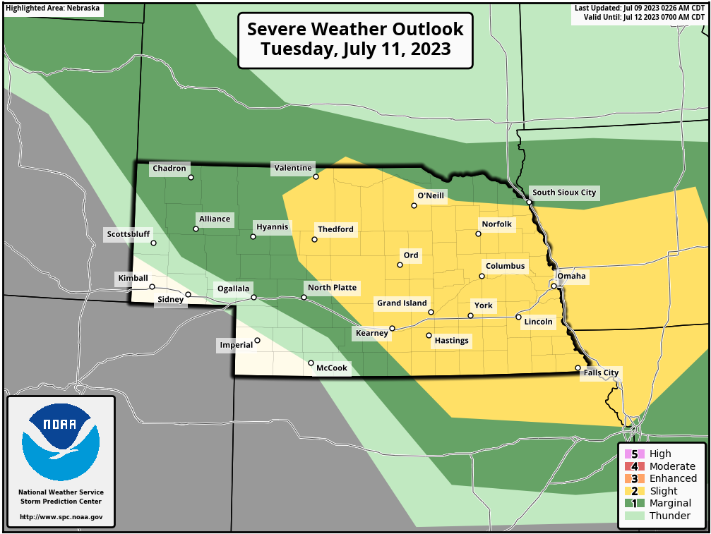
As expected, the SPC has added much of the area (including Omaha) to an outlook for Tuesday. Primarily a damaging wind threat (with some hail) after midnight in our area Tuesday overnight.
Storms are possible Monday night as well though most of it should stay west and north of the Omaha area.
Outlook for Tuesday:
Storms are possible Monday night as well though most of it should stay west and north of the Omaha area.
Outlook for Tuesday:
-
stormchaser
- Planning Board
- Posts: 2380
- Joined: Fri Jun 01, 2018 1:14 pm
Re: 2023 Weather Thread
Still looking like most of the storms today/tonight will miss Omaha to the north and west (as expected).
I saw some of the local media showing simulated radar that had storms impacting Omaha this afternoon already which made me cringe tbh since basically none of the primary forecast models agree (except for the RPM since that's what they like to use on-air) so I'm not sure why they showed that since odds of it happening are extremely low. IF we get anything locally, it won't be until evening and mostly as storms are dying out. The severe weather "should" remain north and west of us today/tonight and mostly be from near Sioux City down toward Columbus and Hastings on west (roughly).
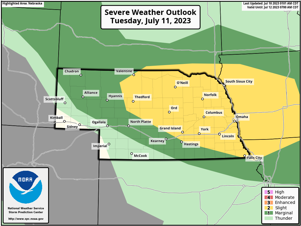
Tomorrow will be our primary severe weather day in the local area with the potential for a damaging wind event (with hail) during the evening/overnight hours - very typical of summer time. Unfortunately this could cause a relatively large swath of damaging wind from far southern SD/north central NE into our area.
Severe weather outlook for tomorrow:
I saw some of the local media showing simulated radar that had storms impacting Omaha this afternoon already which made me cringe tbh since basically none of the primary forecast models agree (except for the RPM since that's what they like to use on-air) so I'm not sure why they showed that since odds of it happening are extremely low. IF we get anything locally, it won't be until evening and mostly as storms are dying out. The severe weather "should" remain north and west of us today/tonight and mostly be from near Sioux City down toward Columbus and Hastings on west (roughly).
Tomorrow will be our primary severe weather day in the local area with the potential for a damaging wind event (with hail) during the evening/overnight hours - very typical of summer time. Unfortunately this could cause a relatively large swath of damaging wind from far southern SD/north central NE into our area.
Severe weather outlook for tomorrow:
-
Omaha Cowboy
- The Don
- Posts: 1013737
- Joined: Wed Jan 07, 2004 11:31 am
- Location: West Omaha
Re: 2023 Weather Thread
Tuesday looks like the potential for a very active evening/overnight..
As always, the hope is for a significant rain event only …
Ciao..LiO…Peace
As always, the hope is for a significant rain event only
…Ciao..LiO…Peace
Go Cowboys!
-
stormchaser
- Planning Board
- Posts: 2380
- Joined: Fri Jun 01, 2018 1:14 pm
Re: 2023 Weather Thread
Possibly anyway. These setups are always concerning from a forecasting perspective because ultimately what you're trying to figure out is exactly what height is the capping and exactly what temp does it need to cool off to for storms to develop and be able to sustain themselves which fluctuates depending on several other factors (so there are a ton of variables to consider in addition to the normal stuff).Omaha Cowboy wrote: Mon Jul 10, 2023 1:32 pm Tuesday looks like the potential for a very active evening/overnight..
As always, the hope is for a significant rain event only
Ciao..LiO…Peace
Additionally, what happens later today/tonight will play a role in what happens tomorrow as the storms tonight will produce different boundaries as they die out, etc for the next round of storms to interact with.
Long story short, it wouldn't surprise me if the primary risk ends up north of Omaha depending on how strong the capping ends up being and the local area ends up getting mostly missed. This is something the 12z HRRR is already showing but it's impossible to really know yet.
-
Omaha Cowboy
- The Don
- Posts: 1013737
- Joined: Wed Jan 07, 2004 11:31 am
- Location: West Omaha
Re: 2023 Weather Thread
Definitely rain and thunder in my area of west Omaha…
Ciao..LiO…Peace
Ciao..LiO…Peace
Go Cowboys!
-
stormchaser
- Planning Board
- Posts: 2380
- Joined: Fri Jun 01, 2018 1:14 pm
Re: 2023 Weather Thread
Yep, remnants of the severe weather to our north. I’ll take the rain though!Omaha Cowboy wrote: Tue Jul 11, 2023 12:44 am Definitely rain and thunder in my area of west Omaha…
Ciao..LiO…Peace
-
Omaha Cowboy
- The Don
- Posts: 1013737
- Joined: Wed Jan 07, 2004 11:31 am
- Location: West Omaha
Re: 2023 Weather Thread
Absolutely agreestormchaser wrote: Tue Jul 11, 2023 1:02 amYep, remnants of the severe weather to our north. I’ll take the rain though!Omaha Cowboy wrote: Tue Jul 11, 2023 12:44 am Definitely rain and thunder in my area of west Omaha…
Ciao..LiO…Peace
 …
Ciao..LiO…Peace
Go Cowboys!
-
Brad

- Photographer
- Posts: 1036702
- Joined: Sun Feb 29, 2004 12:03 am
- Location: Omaha, NE
Re: 2023 Weather Thread
Another great day for photogenic storms in Nebraska today to the north and west.

Omaha Skyline Photos, Omaha Aerial Photos, and More.
Website: www.bradwilliamsphotography.com
Facebook: www.facebook.com/bradwilliamsphotography
Twitter: www.twitter.com/bradwphoto
Instagram: www.instagram.com/bradwilliamsphotography
YouTube: www.youtube.com/@bradwilliamsphoto
-
Cermak
- Planning Board
- Posts: 2348
- Joined: Thu Nov 29, 2018 7:02 pm
Re: 2023 Weather Thread
A good rain yesterday evening. Should help with drought. And no severe weather.
-
stormchaser
- Planning Board
- Posts: 2380
- Joined: Fri Jun 01, 2018 1:14 pm
Re: 2023 Weather Thread
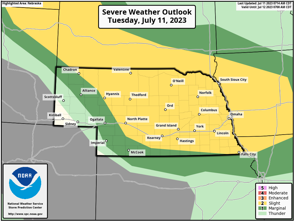
Based on model trends, it is looking less likely that Omaha will miss out on the storms tonight (previous model runs had been showing the possibility of everything staying just north of town).
If these model trends continue, a late night damaging wind event will be likely across much of eastern NE/western IA including in Omaha. This will include the potential for widespread wind damage in addition to at least some hail (though the main threat for large hail will be closer to the NE/SD border as these storms first develop).
This doesn't mean 100% Omaha specifically will be hit. Odds are relatively high but things can always quickly change and it's almost impossible to know for sure.
Here is the day 1 outlook for today. Later this morning, I will post a simulated radar from the 12z HRRR showing the likely track of these storms (once its available in ~45 minutes or so):
If these model trends continue, a late night damaging wind event will be likely across much of eastern NE/western IA including in Omaha. This will include the potential for widespread wind damage in addition to at least some hail (though the main threat for large hail will be closer to the NE/SD border as these storms first develop).
This doesn't mean 100% Omaha specifically will be hit. Odds are relatively high but things can always quickly change and it's almost impossible to know for sure.
Here is the day 1 outlook for today. Later this morning, I will post a simulated radar from the 12z HRRR showing the likely track of these storms (once its available in ~45 minutes or so):
-
stormchaser
- Planning Board
- Posts: 2380
- Joined: Fri Jun 01, 2018 1:14 pm
Re: 2023 Weather Thread
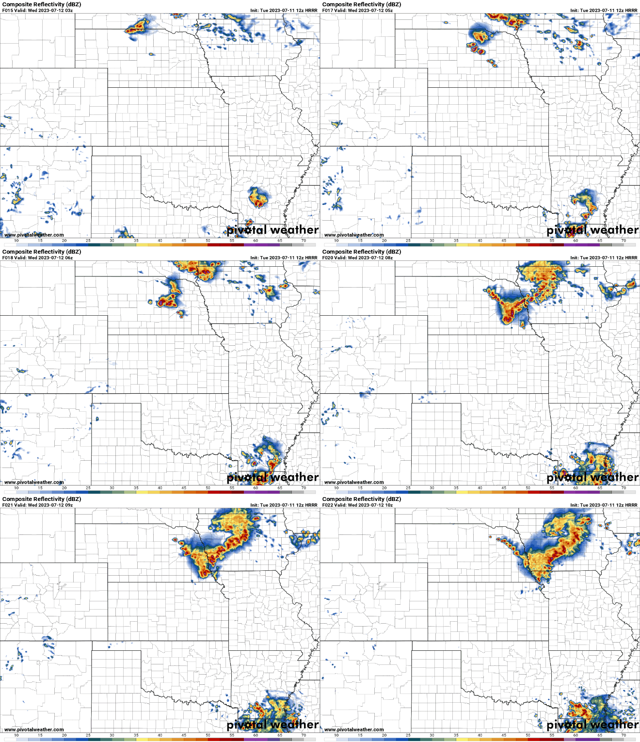
Based on the 12z HRRR, the severe weather threat in the Omaha area will be sometime around 2-3 AM and will include more of a hail threat than I was initially thinking (in addition to damaging wind).
As I've mentioned many times, trying to forecast exact timing with storms like this can be extremely difficult so don't be surprised if the actual time is somewhat different - but sometime after Midnight storms should move into the area.
Radar loop is from 9 PM tonight until 5 AM:
As I've mentioned many times, trying to forecast exact timing with storms like this can be extremely difficult so don't be surprised if the actual time is somewhat different - but sometime after Midnight storms should move into the area.
Radar loop is from 9 PM tonight until 5 AM:
-
stormchaser
- Planning Board
- Posts: 2380
- Joined: Fri Jun 01, 2018 1:14 pm
Re: 2023 Weather Thread
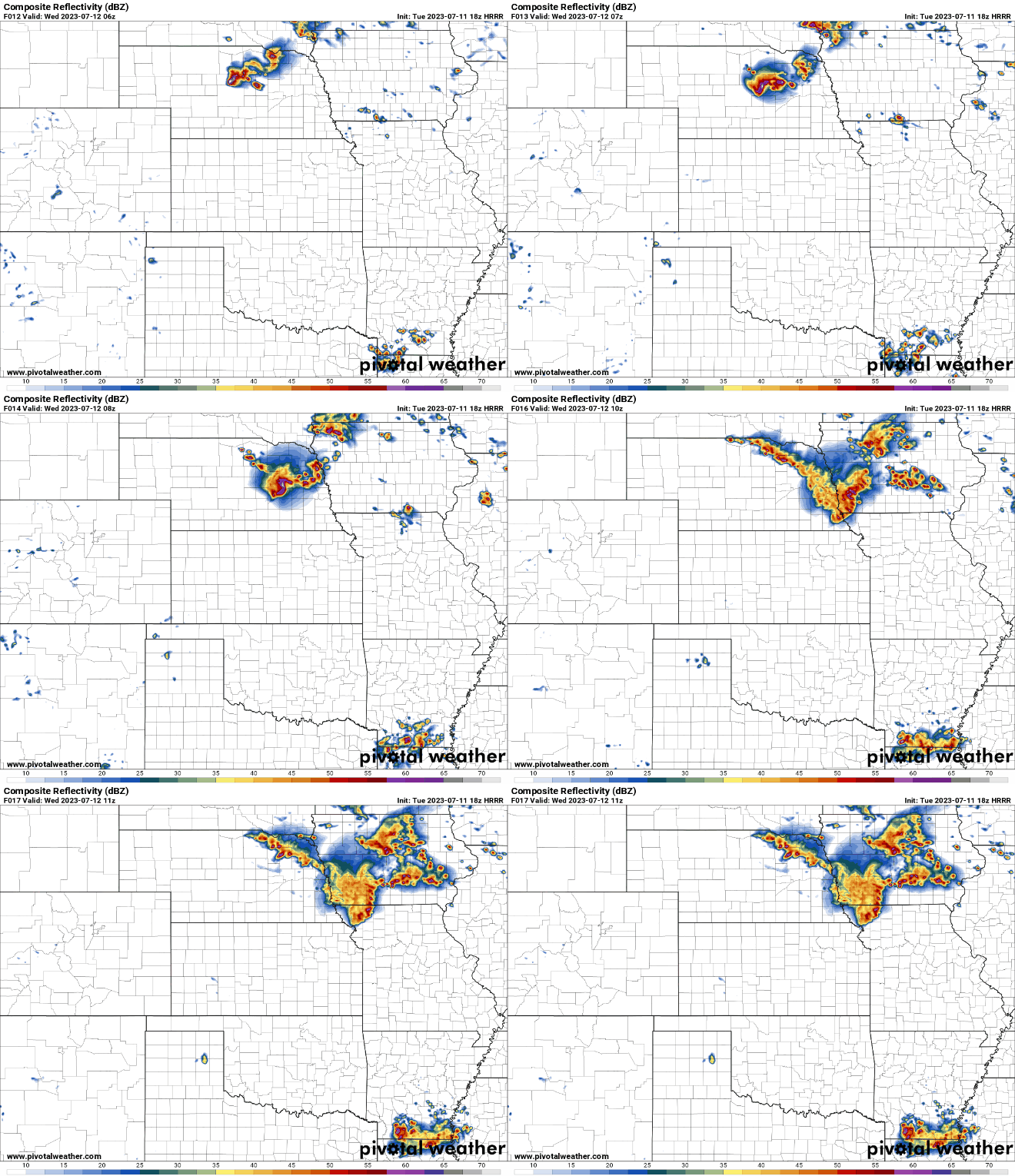
Storms with the potential of producing wind gusts of 70 mph+ are possible after midnight tonight and may cause a swath of significant wind damage from parts of central NE (north of Grand Island down through Columbus, Fremont, Lincoln and the Omaha metro).
It honestly wouldn't surprise me to see localized wind gusts in excess of 80 mph. In addition, large hail will be possible though that is still more likely to happen in parts of central/northern NE.
Right now the area most at risk for significant wind damage appears to be from near Columbus down toward Wahoo (roughly) and possibly through parts of the Omaha metro (southwest side in particular though it's tough to really know).
The highest risk timeframe for the Omaha metro appears to be sometime between 2 AM and 4 AM.
Just giving a heads up that it's looking increasingly likely the overnight is going to be interesting in parts of the area. That doesn't mean things will 100% happens as depicted and maybe we will dodge a bullet but odds are certainly increasing anyway.
Here is a simulated radar from the 18z HRRR showing a pronounced bow that develops in parts of the area:
It honestly wouldn't surprise me to see localized wind gusts in excess of 80 mph. In addition, large hail will be possible though that is still more likely to happen in parts of central/northern NE.
Right now the area most at risk for significant wind damage appears to be from near Columbus down toward Wahoo (roughly) and possibly through parts of the Omaha metro (southwest side in particular though it's tough to really know).
The highest risk timeframe for the Omaha metro appears to be sometime between 2 AM and 4 AM.
Just giving a heads up that it's looking increasingly likely the overnight is going to be interesting in parts of the area. That doesn't mean things will 100% happens as depicted and maybe we will dodge a bullet but odds are certainly increasing anyway.
Here is a simulated radar from the 18z HRRR showing a pronounced bow that develops in parts of the area:
-
Omaha Cowboy
- The Don
- Posts: 1013737
- Joined: Wed Jan 07, 2004 11:31 am
- Location: West Omaha
Re: 2023 Weather Thread
Yeah- a severe weather threat is never the best overnight when everyone is sleeping..stormchaser wrote: Tue Jul 11, 2023 7:36 pm Storms with the potential of producing wind gusts of 70 mph+ are possible after midnight tonight and may cause a swath of significant wind damage from parts of central NE (north of Grand Island down through Columbus, Fremont, Lincoln and the Omaha metro).
It honestly wouldn't surprise me to see localized wind gusts in excess of 80 mph. In addition, large hail will be possible though that is still more likely to happen in parts of central/northern NE.
Right now the area most at risk for significant wind damage appears to be from near Columbus down toward Wahoo (roughly) and possibly through parts of the Omaha metro (southwest side in particular though it's tough to really know).
The highest risk timeframe for the Omaha metro appears to be sometime between 2 AM and 4 AM.
Just giving a heads up that it's looking increasingly likely the overnight is going to be interesting in parts of the area. That doesn't mean things will 100% happens as depicted and maybe we will dodge a bullet but odds are certainly increasing anyway.
Here is a simulated radar from the 18z HRRR showing a pronounced bow that develops in parts of the area:
Thanks for the intel and here’s hoping we just get another decent rain and some thunder…
Ciao..LiO…Peace
Go Cowboys!
-
Busguy2010

- City Council
- Posts: 7393
- Joined: Sun Apr 10, 2011 12:32 am
- Location: North Central Omaha
Re: 2023 Weather Thread
Hopefully not a repeat of July 10th, 2021.
I've seen all sources and they are all trending the point of the bow echo would be slightly south of here. We all know there's no guarantees though. Seems like a pretty sure bet there'll be a fairly significant event.
I've seen all sources and they are all trending the point of the bow echo would be slightly south of here. We all know there's no guarantees though. Seems like a pretty sure bet there'll be a fairly significant event.
-
Omaha Cowboy
- The Don
- Posts: 1013737
- Joined: Wed Jan 07, 2004 11:31 am
- Location: West Omaha
Re: 2023 Weather Thread
Definitely don’t need another July 10th 2021. We had 90mph wind gusts with that storm and a ton of tree damage…
Ciao..LiO…Peace
Ciao..LiO…Peace
Go Cowboys!
-
stormchaser
- Planning Board
- Posts: 2380
- Joined: Fri Jun 01, 2018 1:14 pm
Re: 2023 Weather Thread
It probably won’t be as bad as that event but still potentially pretty bad. Latest model run of the HRRR hits Omaha pretty hard (previous runs were slightly south) but things have been fluctuating between a damaging wind event and a heavy rain event (with minimal severe weather). I’m still expecting a damaging wind event but that trend will need to be watched over the next few hours.Busguy2010 wrote: Tue Jul 11, 2023 10:22 pm Hopefully not a repeat of July 10th, 2021.
I've seen all sources and they are all trending the point of the bow echo would be slightly south of here. We all know there's no guarantees though. Seems like a pretty sure bet there'll be a fairly significant event.
Based on the mesoanalysis, a boundary exists basically from near Rapid City directly to Omaha so I’m expecting Omaha to probably be in the main risk area for damaging wind (if there is that threat which I believe there will be but only time will tell).
I’m still thinking 2 AM - 4 AM will be the primary time frame for damaging wind locally. Additionally we will likely get some pretty heavy rain.
Last edited by stormchaser on Tue Jul 11, 2023 11:26 pm, edited 1 time in total.
-
stormchaser
- Planning Board
- Posts: 2380
- Joined: Fri Jun 01, 2018 1:14 pm
Re: 2023 Weather Thread
Unfortunately there will be that potential but I don’t think this round will be quite that bad but we will see.Omaha Cowboy wrote: Tue Jul 11, 2023 10:32 pm Definitely don’t need another July 10th 2021. We had 90mph wind gusts with that storm and a ton of tree damage…
Ciao..LiO…Peace
-
GetUrban
- Planning Board
- Posts: 2650
- Joined: Sun Nov 23, 2008 9:07 pm
- Location: Omaha
Re: 2023 Weather Thread
Given what might be coming later tonight, it’s a good time to gather up any loose lawn furniture, hammocks, stacking chairs, umbrellas, etc. and get them stowed out of the way of potential paths of wind.
He said "They are some big, ugly red brick buildings"
...and then they were gone.
...and then they were gone.
-
stormchaser
- Planning Board
- Posts: 2380
- Joined: Fri Jun 01, 2018 1:14 pm
Re: 2023 Weather Thread
Definitely a good idea though my confidence is gradually decreasing as recent model runs have added more uncertainty than anything.GetUrban wrote: Wed Jul 12, 2023 12:49 am Given what might be coming later tonight, it’s a good time to gather up any loose lawn furniture, hammocks, stacking chairs, umbrellas, etc. and get them stowed out of the way of potential paths of wind.
That doesn't mean we won't get hit now but odds have started to decrease again. Obviously don't let down your guard but the cap may prove too strong this time and have much of the storms/severe weather miss us to the north (and possibly a big chunk of the precip too).
Gotta love forecasting these things. Just a TINY change in the temp aloft can make a HUGE difference in what actually happens and forecast models are currently struggling with trying to figure it out.
-
Busguy2010
- City Council
- Posts: 7393
- Joined: Sun Apr 10, 2011 12:32 am
- Location: North Central Omaha
Re: 2023 Weather Thread
Looks like the storms are currently thriving up in the NW corner of SD. Guessing those are the ones that will make it here later, correct me if I'm wrong. Local news outlets said they'd fire farther south and a lot earlier. They were saying 2am on our door step, now I wouldn't be surprised with 5-7am.
-
stormchaser
- Planning Board
- Posts: 2380
- Joined: Fri Jun 01, 2018 1:14 pm
Re: 2023 Weather Thread
Looks like the track shifted north but not enough to miss Omaha. Storms moving in, some with 80+ mph wind’s reported though most places it won’t be that strong. Widespread tree damage is fairly likely though.
-
Louie
- County Board
- Posts: 4968
- Joined: Fri Dec 23, 2011 10:23 pm
- Location: Dundee
Re: 2023 Weather Thread
Lotta rain, some wind but definitely nothing over 50mph. Ive seen a handful of pea size hail.
-
Cermak
- Planning Board
- Posts: 2348
- Joined: Thu Nov 29, 2018 7:02 pm
Re: 2023 Weather Thread
Same here in SW Omaha, not on the scale as the storm almost exactly 2 years ago, luckily.Louie wrote: Wed Jul 12, 2023 11:32 am Lotta rain, some wind but definitely nothing over 50mph. Ive seen a handful of pea size hail.
-
ShawJ
- Parks & Recreation
- Posts: 1573
- Joined: Wed Jan 31, 2007 11:58 pm
Re: 2023 Weather Thread
Was a little gnarly north of town. High winds and power is out, but wasn’t as bad as I thought it was going to be based on the radar.
-
stormchaser
- Planning Board
- Posts: 2380
- Joined: Fri Jun 01, 2018 1:14 pm
Re: 2023 Weather Thread
Yeah north side of Omaha on north lots of reports of 70-80+ mph. I’m not surprised it wasn’t to the scale of the big July storm - parameters weren’t really the same. But significant tree damage reported in some areas (like Fort Calhoun, etc)
-
stormchaser
- Planning Board
- Posts: 2380
- Joined: Fri Jun 01, 2018 1:14 pm
Re: 2023 Weather Thread
Some of the wind speeds and damage reports from the area (there are more).
Several reports of 70 mph+ winds and at least one of over 80 mph.
Reported wind speed is the 2nd number in from the left:
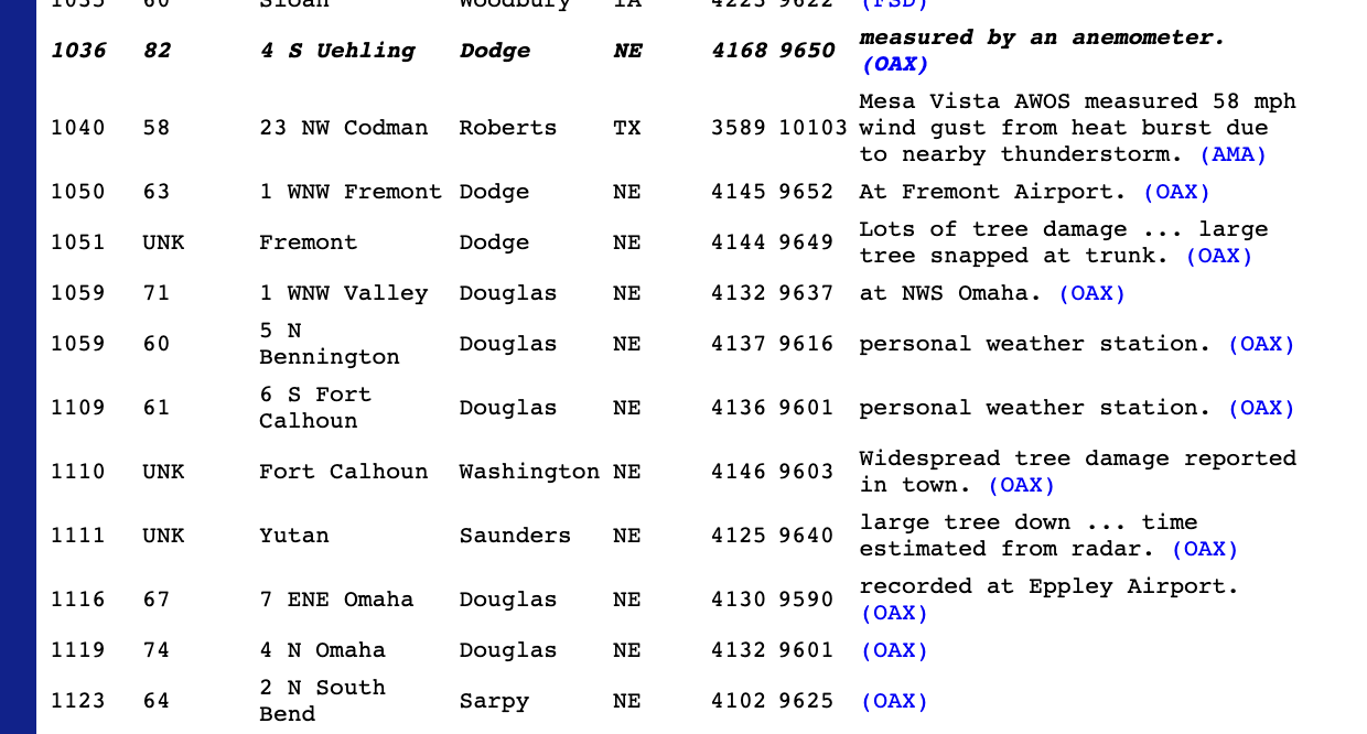
Full list of wind/damage reports can be found here: https://www.spc.noaa.gov/climo/reports/230711_rpts.html
Several reports of 70 mph+ winds and at least one of over 80 mph.
Reported wind speed is the 2nd number in from the left:
Full list of wind/damage reports can be found here: https://www.spc.noaa.gov/climo/reports/230711_rpts.html
-
Coyote
- City Council
- Posts: 34365
- Joined: Tue Nov 18, 2003 5:18 pm
- Yahoo Messenger: jestcoyote
- Location: Aksarben Village
Re: 2023 Weather Thread
KETV viewers capture Wednesday morning's severe weather
KETV NewsWatch 7 viewers reported damage as the thunderstorms moved through the metro.
KETV NewsWatch 7 viewers reported damage as the thunderstorms moved through the metro.
-
Coyote
- City Council
- Posts: 34365
- Joined: Tue Nov 18, 2003 5:18 pm
- Yahoo Messenger: jestcoyote
- Location: Aksarben Village
Re: 2023 Weather Thread
Thunderstorms cause power outages, down trees in Omaha area
Thunderstorms caused power outages, down trees in Omaha area on Wednesday morning.
Thunderstorms caused power outages, down trees in Omaha area on Wednesday morning.
-
Coyote
- City Council
- Posts: 34365
- Joined: Tue Nov 18, 2003 5:18 pm
- Yahoo Messenger: jestcoyote
- Location: Aksarben Village
Re: 2023 Weather Thread
Thunderstorm front moves into Omaha on Wednesday morning
KETV Chief Photographer Scott Buer captured the storm front moving into Omaha from the 10th Street bridge.
KETV Chief Photographer Scott Buer captured the storm front moving into Omaha from the 10th Street bridge.
-
Coyote
- City Council
- Posts: 34365
- Joined: Tue Nov 18, 2003 5:18 pm
- Yahoo Messenger: jestcoyote
- Location: Aksarben Village
Re: 2023 Weather Thread
Wednesday morning storms bring rain and wind
Wednesday morning storms bring rain and wind to the Omaha area
Wednesday morning storms bring rain and wind to the Omaha area
-
Omaha Cowboy
- The Don
- Posts: 1013737
- Joined: Wed Jan 07, 2004 11:31 am
- Location: West Omaha
Re: 2023 Weather Thread
You were pretty spot on. Had some tree/limb damage in my area of west Omaha. Fortunately my property was okay…stormchaser wrote: Wed Jul 12, 2023 11:50 am Yeah north side of Omaha on north lots of reports of 70-80+ mph. I’m not surprised it wasn’t to the scale of the big July storm - parameters weren’t really the same. But significant tree damage reported in some areas (like Fort Calhoun, etc)
Ciao..LiO…Peace
Go Cowboys!
-
skinzfan23
- City Council
- Posts: 11672
- Joined: Mon Feb 09, 2004 5:26 pm
- Location: Omaha/Bellevue
Re: 2023 Weather Thread
1.25” south of Bellevue….hopefully putting a further dent in the drought
-
stormchaser
- Planning Board
- Posts: 2380
- Joined: Fri Jun 01, 2018 1:14 pm
Re: 2023 Weather Thread
Timing was off some but that's usually the toughest part and the track shifted slightly further north and impacted more of the north metro than the south...but still, not a bad overall forecast even though my confidence started to decrease some last nightOmaha Cowboy wrote: Wed Jul 12, 2023 3:00 pmYou were pretty spot on. Had some tree/limb damage in my area of west Omaha. Fortunately my property was okay…stormchaser wrote: Wed Jul 12, 2023 11:50 am Yeah north side of Omaha on north lots of reports of 70-80+ mph. I’m not surprised it wasn’t to the scale of the big July storm - parameters weren’t really the same. But significant tree damage reported in some areas (like Fort Calhoun, etc)
Ciao..LiO…Peace
...-
Cermak
- Planning Board
- Posts: 2348
- Joined: Thu Nov 29, 2018 7:02 pm
Re: 2023 Weather Thread
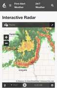
Not the best thing to wake up to at 6:30 am.
-
Brad
- Photographer
- Posts: 1036702
- Joined: Sun Feb 29, 2004 12:03 am
- Location: Omaha, NE
Re: 2023 Weather Thread
If you are interested in weather, you should purchase the Radar Scope app. That thing was way more impressive in velocity mode! The entry level app is only $10.
Omaha Skyline Photos, Omaha Aerial Photos, and More.
Website: www.bradwilliamsphotography.com
Facebook: www.facebook.com/bradwilliamsphotography
Twitter: www.twitter.com/bradwphoto
Instagram: www.instagram.com/bradwilliamsphotography
YouTube: www.youtube.com/@bradwilliamsphoto
-
Brad
- Photographer
- Posts: 1036702
- Joined: Sun Feb 29, 2004 12:03 am
- Location: Omaha, NE
Re: 2023 Weather Thread
Looks like the first survey from this morning is in and Bancroft, NE had an EF1 tornado.
Half mile long with 100mph winds. Assuming it was a classic QLSC on the leading edge of the line.
Half mile long with 100mph winds. Assuming it was a classic QLSC on the leading edge of the line.
Omaha Skyline Photos, Omaha Aerial Photos, and More.
Website: www.bradwilliamsphotography.com
Facebook: www.facebook.com/bradwilliamsphotography
Twitter: www.twitter.com/bradwphoto
Instagram: www.instagram.com/bradwilliamsphotography
YouTube: www.youtube.com/@bradwilliamsphoto