Busguy2010 wrote: Tue Aug 01, 2023 5:03 pmI'm starting to see hints of fall.
I don't think it's really signs of fall yet. We haven't even passed halfway through summer. NOAA had predicted August to be cooler than normal for the center of the country.
The only hints of Fall I see, is when I go into a fine bottle shop and see Pumpkin Beers and Oktoberfest beers already available to purchase as of August 1st, lol…
Omaha Cowboy wrote: Tue Aug 01, 2023 10:00 pm
The only hints of Fall I see, is when I go into a fine bottle shop and see Pumpkin Beers and Oktoberfest beers already available to purchase as of August 1st, lol…
Ciao..LiO…Peace
I saw Halloween decorations on sale as you entered the front door of Lowe's the other day! It wasn't even August yet.
Probably one of the cooler and wetter July's in Omaha that I can remember. We had a few miserable hot days at the end of July but that was about it. I'm enjoying this weather today with the clouds and temps in low 80's, although it is still quite humid out.
Omaha Cowboy wrote: Tue Aug 01, 2023 10:00 pm
The only hints of Fall I see, is when I go into a fine bottle shop and see Pumpkin Beers and Oktoberfest beers already available to purchase as of August 1st, lol…
Ciao..LiO…Peace
I saw Halloween decorations on sale as you entered the front door of Lowe's the other day! It wasn't even August yet.
Yep and Halloween candy is now for sale at most all grocery stores.. Crazy!..
As far as the weather goes, according to the weather team at KETV, it”s going to be uncomfortably humid in the Omaha area for the next few days…
skinzfan23 wrote: Wed Aug 02, 2023 2:40 pm
Crazy, I just checked about an hr ago and I only have .25" in Bellevue, we have missed most of it to the north.
As of 6AM, Springfield got slightly damp streets and that was it. Now that I'm at work in Southport, I've had moderate trending toward light rainfall since 8AM. Couple close lightning strikes, too.
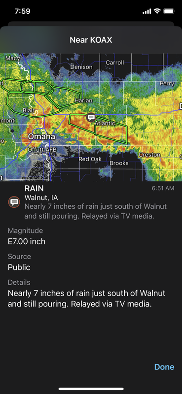
WOW 7" at walnut. Any way to know what they ended up with? That reminds me of the deluge that we had in Omaha I think 2018 or 2019, we got over 8" over the course of 26 hours or so. But over 7" in just a few? Wow, that must have been crazy.
Busguy2010 wrote: Wed Aug 02, 2023 4:17 pm
WOW 7" at walnut. Any way to know what they ended up with? That reminds me of the deluge that we had in Omaha I think 2018 or 2019, we got over 8" over the course of 26 hours or so. But over 7" in just a few? Wow, that must have been crazy.
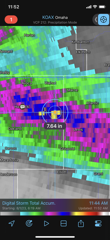
Looks like it technically was just south of Walnut but based on radar estimates, somewhere between 7.5" and 8" probably...
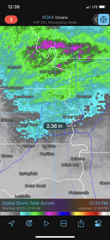
Can you share the rainfall image on that app for Omaha?
Louie wrote: Wed Aug 02, 2023 5:02 pm
Can you share the rainfall image on that app for Omaha?
Yep, basically anything in blue is 2"+ of rain so many areas along and north of I-80 saw those totals (roughly) with areas in light green between 2.5" and 3" of rain. Areas around Papillion and Bellevue saw closer to .5" of rain.
Brad wrote: Thu Aug 03, 2023 4:45 am
Near 90th and Center, I ended up with 2.44 for the Day, and I'm now at 3.50" in the past 3 days, 4.12 inches in the past 7 Days.
Craziest part was that I got 1.32" is only 20 min this morning from 8 to 8:20!
That's a fun little burst of heavy rain...lol
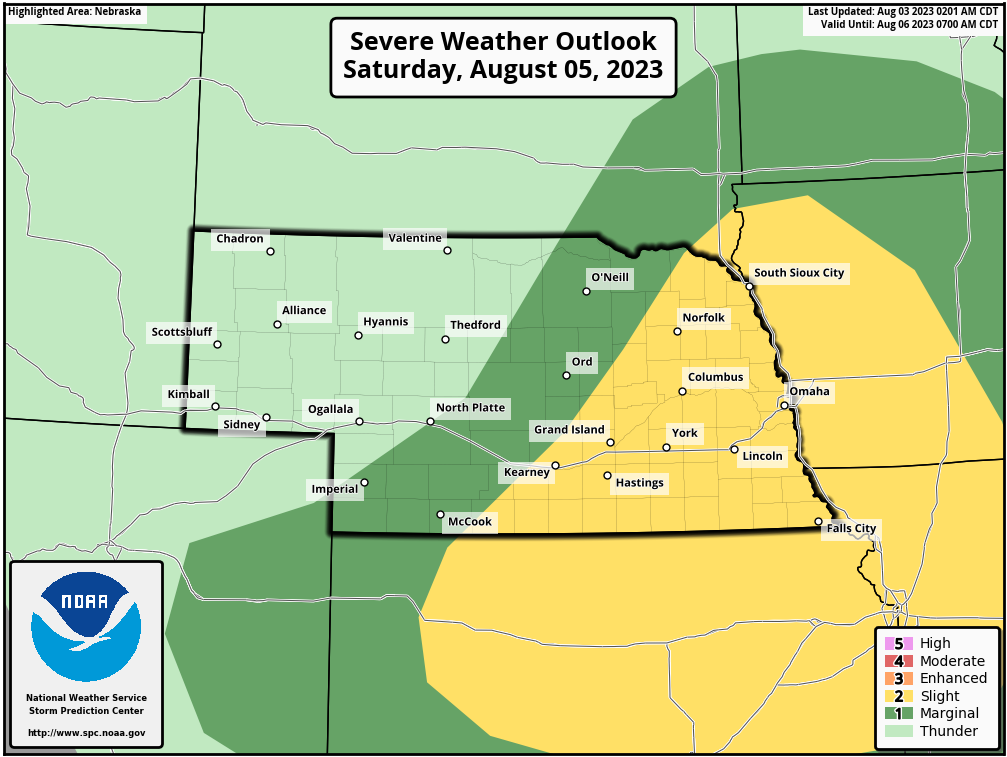
Next best chance for storms/potential severe weather is Saturday (though there is a chance we get a few storms between now and then too).
The SPC has a day 3 outlook for Saturday that includes our area:
I really wish we could have some sunny days. The constant clouds for a vast majority of everyday has been difficult. It has been almost as bad as winter.
BRoss wrote: Thu Aug 03, 2023 1:58 pm
I really wish we could have some sunny days. The constant clouds for a vast majority of everyday has been difficult. It has been almost as bad as winter.
Haha, I was discussing this with some co-workers the other day. Can't tell what time of day it is when its cloudy all the time.
BRoss wrote: Thu Aug 03, 2023 1:58 pm
I really wish we could have some sunny days. The constant clouds for a vast majority of everyday has been difficult. It has been almost as bad as winter.
I agree with you there. With all the rain we've had, it's been a solidly cloudy stretch. Looks like not a fully sunny day in the next ten days according to WOWT. A bit depressing, but I'm thankful for it keeping the temps down. Looks like this weekend will struggle to reach 80, and Monday should be pretty comfortable, 70's all day with dew points in the low 60's. Should feel slightly fall-like.
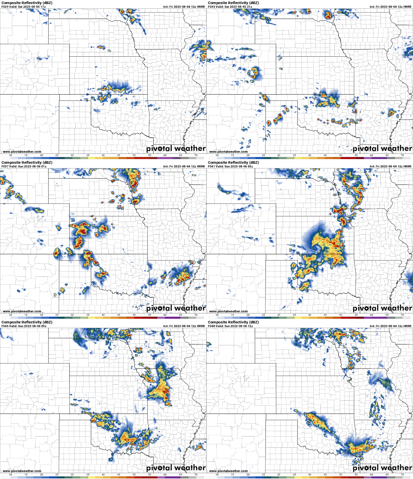
Based on the last several runs of the HRRR, somewhere in or near the Omaha area "potentially" could end up with a supercell during the late afternoon/early evening hours tomorrow with the potential for large/very large hail and at least some tornado threat.
The HRRR has been consistently showing since last night a storm developing along a boundary (a small warm front) in our area out ahead of the southeast advancing cold front. Surface winds look light but they will be backed (southeasterly) and if the storm embeds on the boundary and starts moving southeasterly (as depicted), it "might" have enough helicity/inflow to wrap up and produce a tornado despite the relatively light southeasterly low level winds before the cold front catches it and undercuts the storm (effectively killing it off with storm development occurring behind the supercell along the cold front itself).
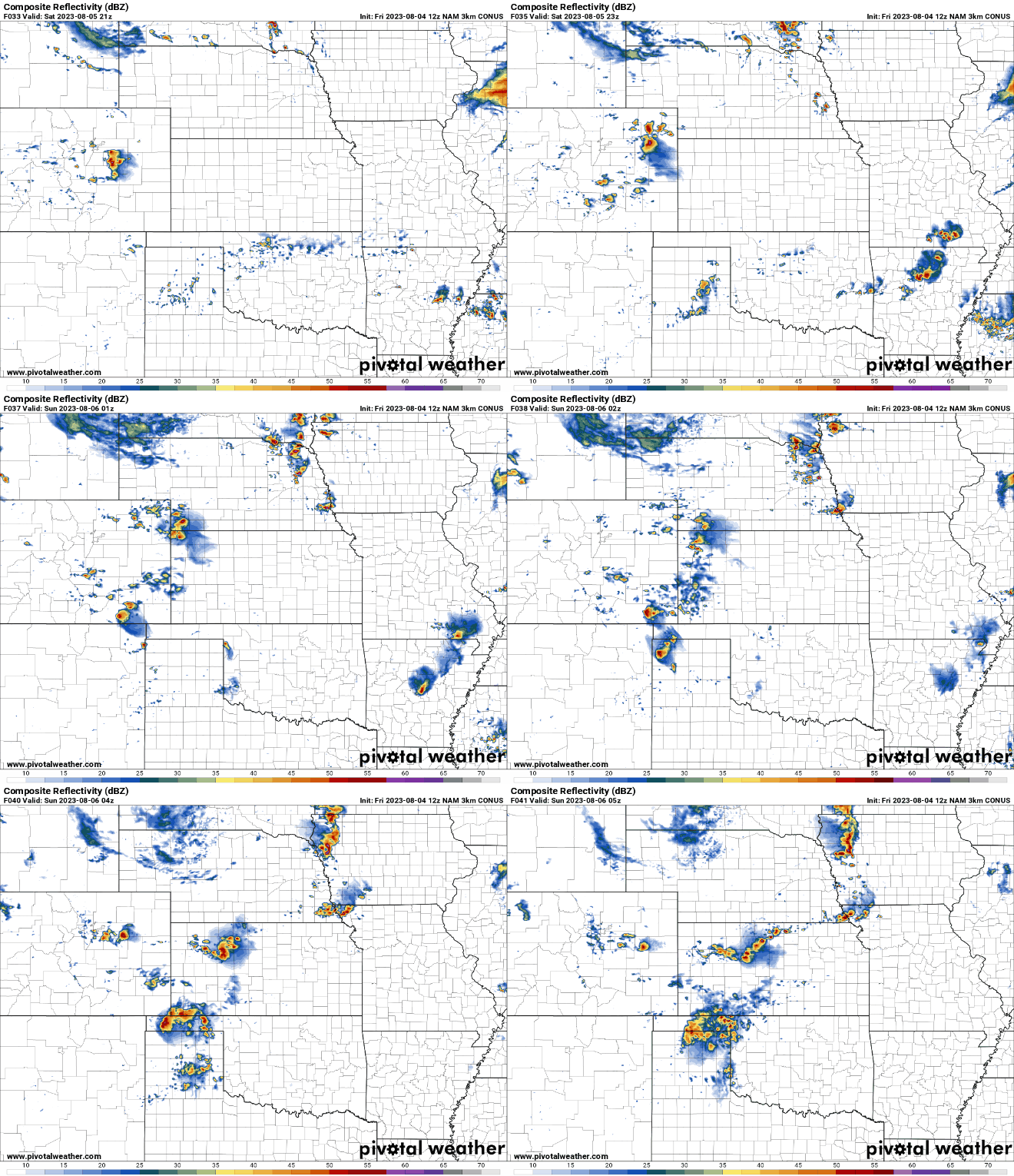
Here is a simulated radar from the 12z HRRR showing this potential supercell developing in our area and blowing up before the cold front catches it and additional storms develop in the area. Obviously who knows if this is the scenario that will happen since it's over 24 hours out yet and things can quickly change, but still - definitely potential for a big storm in the local area anyway.
For what it's worth, there is good model agreement too showing this potential supercells/strong storm developing in our area (granted this model is a bit further south with things though it's also underestimating things too IMO).
Here is the simulated radar from the 12z 3km model:
Both KETV and WOWT were saying there would be a big storm, but also they agreed that it would be south of here, Cass, Lancaster, Otoe counties, which is what your last run agrees with
Busguy2010 wrote: Fri Aug 04, 2023 7:06 pm
Both KETV and WOWT were saying there would be a big storm, but also they agreed that it would be south of here, Cass, Lancaster, Otoe counties, which is what your last run agrees with
Just depends where the boundary ends up tomorrow...
almighty_tuna wrote: Fri Aug 04, 2023 7:15 pm
Just thundershowers overnight tonight then?
Most of the stuff tonight should stay west/northwest of here as things will probably die out before getting here and also to our southeast into MO where there is a pretty decent severe threat later today.
However, there are storms in the local area currently too (on the south side of town right now anyway but new stuff forming along and near I-80/480 currently). Nothing severe warned but still some pretty heavy rain in some areas since they are barely moving.
The more rain the merrier, lol..
That said, we could use a couple day stretch to dry out and get sunny…
Haven't seen the local news since earlier, but the NWS is saying main threat is between 7 and midnight, maybe even moreso between 10p and 1am. That would be nice to finally have a viewable storm, not something like 3-5am.
Supercell potential ahead of the other storms has decreased for the Omaha area though severe and tornado potential has increased for later today (mostly this evening) - especially from Omaha on north.
Since the storms will be scattered and predominantly north of Omaha, don’t be surprised if in Omaha itself we don’t get much (if anything) for storms today/tonight. Obviously don’t let down your guard but odds aren’t great IMO anyway. Somewhere around Sioux City is my initial target…
Storms are at least trying to break the cap just west of Omaha. If they do, expect supercell potential in the area. Something to watch close over the next few hours.