Anybody wanna set an over/under (before/after) date for frozen precipitation for fun?
If it's me I'll set it at October 31st at 11:59:59 pm and take the after.
2023 Weather Thread
-
Busguy2010

- City Council
- Posts: 7393
- Joined: Sun Apr 10, 2011 12:32 am
- Location: North Central Omaha
-
stormchaser
- Planning Board
- Posts: 2380
- Joined: Fri Jun 01, 2018 1:14 pm
Re: 2023 Weather Thread
Are you talking accumulation or just the first flakes? If you're referring to the first flakes, I'll take the before (barely). If you're referring to accumulating snow, I'll take the after.Busguy2010 wrote: Fri Oct 06, 2023 7:11 pm Anybody wanna set an over/under (before/after) date for frozen precipitation for fun?
If it's me I'll set it at October 31st at 11:59:59 pm and take the after.
-
Omaha Cowboy

- The Don
- Posts: 1013736
- Joined: Wed Jan 07, 2004 11:31 am
- Location: West Omaha
Re: 2023 Weather Thread
My guess is we’ll be accumulating snow free in the Omaha area until the first week in December.stormchaser wrote: Fri Oct 06, 2023 3:44 pm Any guesses on when we will receive our first snowfall in the Omaha metro this year?
My guess/prediction for Omaha itself:
We will see our first flakes/flurries October 29th and our first "accumulating" snowfall (an inch or more - none of this just a dusting stuff) on November 10th.
What's your guess/prediction (for the fun of it of course)?
Flakes/Flurries by mid November (around the 15th)…
Ciao..LiO…Peace
Go Cowboys!
-
Busguy2010
- City Council
- Posts: 7393
- Joined: Sun Apr 10, 2011 12:32 am
- Location: North Central Omaha
Re: 2023 Weather Thread
Any flakes, sleet, or groppel would apply IMO, so I stick with my prediction, nothing before November 1st. But I'm with Cowboy, I doubt there'll be anything signicant before at least Thanksgiving.
And a side note, my reading for this mornings low was 38, so not as cold as I expected.
And a side note, my reading for this mornings low was 38, so not as cold as I expected.
-
stormchaser
- Planning Board
- Posts: 2380
- Joined: Fri Jun 01, 2018 1:14 pm
Re: 2023 Weather Thread
I'd be okay with it being a later start to winter weather this year  . Only time will tell.
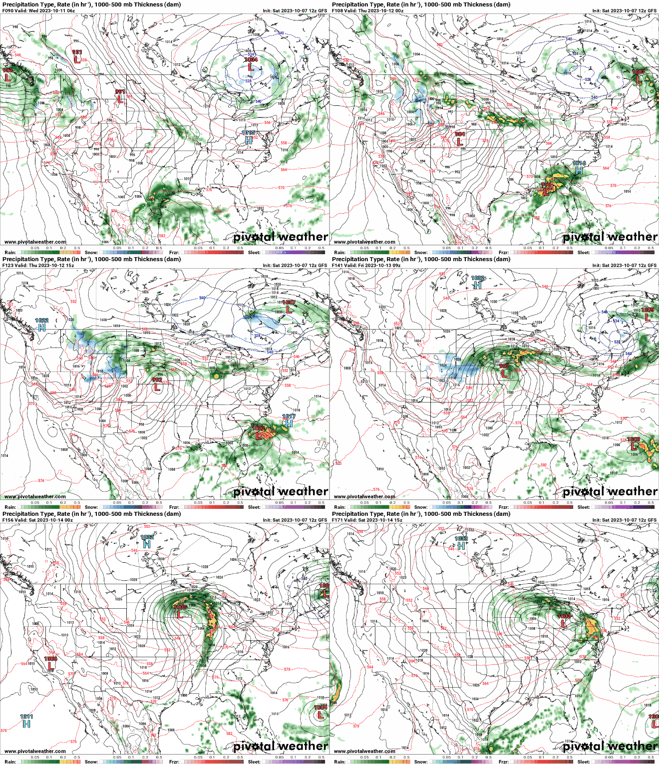
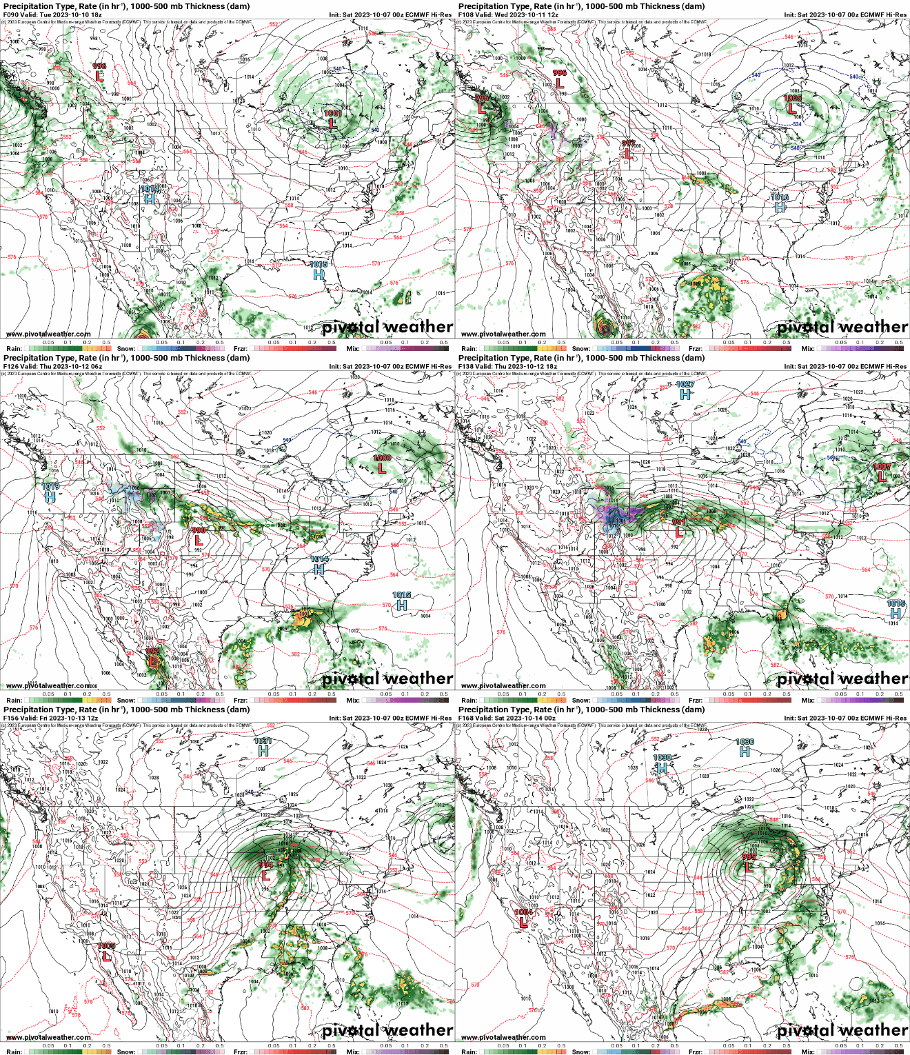
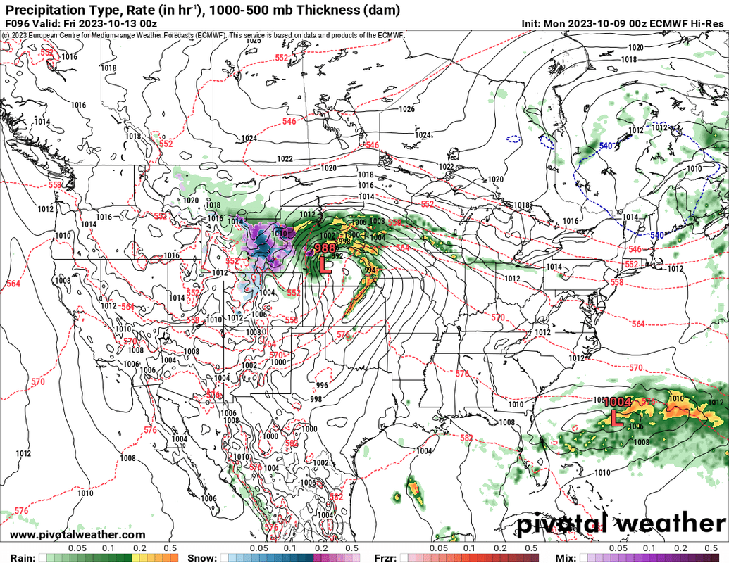
Both the 12z GFS from today and the 00z ECMWF from last night (the 12z isn't available yet) shows a powerful storm system in our area toward the end of next week into next weekend (starting Thursday evening roughly). Since there is decent model agreement and there has been run to run consistency, odds are higher but of course it's too far out to be confident yet in what to really expect.
This will include the potential for severe weather on Thursday somewhere in the region (along a warm front and with a strong low probably so depending on how things come together, maybe tornado potential). Obviously who knows exactly where yet since it's a long ways out but potentially here at least. Something to keep a close eye on.
In addition to a severe weather threat, there will probably be a pretty large area of moderate to heavy rainfall with this. On the back side of this large area of precip, some snow potential. Especially in western/central NE but a few flakes can't be ruled out here after the low passes by.
Regardless, probably a few days of strong wind/cold temps behind it.
It's worth mentioning the GFS typically has more of a cold bias than the ECMWF. Consequently, it shows a larger area of snow than what the ECMWF is showing. If temps were slightly colder, this would probably end up being a pretty big snow storm. Temps will need to be watched closely in the coming days to see if anything starts trending colder. Yes, I realize snow typically melts as it falls this time of year. However, if heavy enough snow occurs during night time, it can still accumulate. Doubtful that happens this time if there ends up being any snow in Nebraska but something to watch.
Here is an animated loop from the 12z GFS showing this storm system late next week into next weekend.
Here is an animated loop from the 00z ECMWF which also shows this storm system but isn't as cold. It takes more of a path that would give Omaha heavy snow if it was colder.
. Only time will tell.Both the 12z GFS from today and the 00z ECMWF from last night (the 12z isn't available yet) shows a powerful storm system in our area toward the end of next week into next weekend (starting Thursday evening roughly). Since there is decent model agreement and there has been run to run consistency, odds are higher but of course it's too far out to be confident yet in what to really expect.
This will include the potential for severe weather on Thursday somewhere in the region (along a warm front and with a strong low probably so depending on how things come together, maybe tornado potential). Obviously who knows exactly where yet since it's a long ways out but potentially here at least. Something to keep a close eye on.
In addition to a severe weather threat, there will probably be a pretty large area of moderate to heavy rainfall with this. On the back side of this large area of precip, some snow potential. Especially in western/central NE but a few flakes can't be ruled out here after the low passes by.
Regardless, probably a few days of strong wind/cold temps behind it.
It's worth mentioning the GFS typically has more of a cold bias than the ECMWF. Consequently, it shows a larger area of snow than what the ECMWF is showing. If temps were slightly colder, this would probably end up being a pretty big snow storm. Temps will need to be watched closely in the coming days to see if anything starts trending colder. Yes, I realize snow typically melts as it falls this time of year. However, if heavy enough snow occurs during night time, it can still accumulate. Doubtful that happens this time if there ends up being any snow in Nebraska but something to watch.
Here is an animated loop from the 12z GFS showing this storm system late next week into next weekend.
Here is an animated loop from the 00z ECMWF which also shows this storm system but isn't as cold. It takes more of a path that would give Omaha heavy snow if it was colder.
Last edited by stormchaser on Sat Oct 07, 2023 5:59 pm, edited 4 times in total.
-
nativeomahan

- County Board
- Posts: 6026
- Joined: Fri Nov 12, 2004 8:46 pm
- Location: Omaha and Puerto Vallarta
Re: 2023 Weather Thread
It reached down to 40f at our house this morning. I could definitely see my breath for the first time this autumn,
-
stormchaser
- Planning Board
- Posts: 2380
- Joined: Fri Jun 01, 2018 1:14 pm
Re: 2023 Weather Thread
Odds continue to increase that our area will be impacted by a strong storm system in the later half of this upcoming week. The 12z GFS and 12z ECMWF are both in relatively good agreement so odds of a strong storm system verifying are about as high as they can be this far out.
However, the exact track of the low is yet to be determined. and exactly where it tracks and when will be key in what kind of impacts Omaha specifically sees.
The potential for severe weather (including potential tornadoes) somewhere in the area also continue to increase on Thursday in particular. If the track of the low shown on the 12z ECMWF verifies, Omaha is definitely at risk (including a higher risk of tornadoes if things verify as shown). If the 12z GFS verifies, that main risk may end up more into far southeast Nebraska and adjacent parts of Missouri and Iowa.
Model trends will need to be watched closely as this is looking like a pretty classic early fall severe weather/potential tornado outbreak (at least on a localized basis) that may occur in our area or not very far from our area anyway.
Still looking like parts of Nebraska will see some snowfall as well - even maybe into central Nebraska. It's still impossible to completely rule out flurries as far east is the Omaha area after the low passes by (though it's unlikely currently).
However, the exact track of the low is yet to be determined. and exactly where it tracks and when will be key in what kind of impacts Omaha specifically sees.
The potential for severe weather (including potential tornadoes) somewhere in the area also continue to increase on Thursday in particular. If the track of the low shown on the 12z ECMWF verifies, Omaha is definitely at risk (including a higher risk of tornadoes if things verify as shown). If the 12z GFS verifies, that main risk may end up more into far southeast Nebraska and adjacent parts of Missouri and Iowa.
Model trends will need to be watched closely as this is looking like a pretty classic early fall severe weather/potential tornado outbreak (at least on a localized basis) that may occur in our area or not very far from our area anyway.
Still looking like parts of Nebraska will see some snowfall as well - even maybe into central Nebraska. It's still impossible to completely rule out flurries as far east is the Omaha area after the low passes by (though it's unlikely currently).
-
stormchaser
- Planning Board
- Posts: 2380
- Joined: Fri Jun 01, 2018 1:14 pm
Re: 2023 Weather Thread
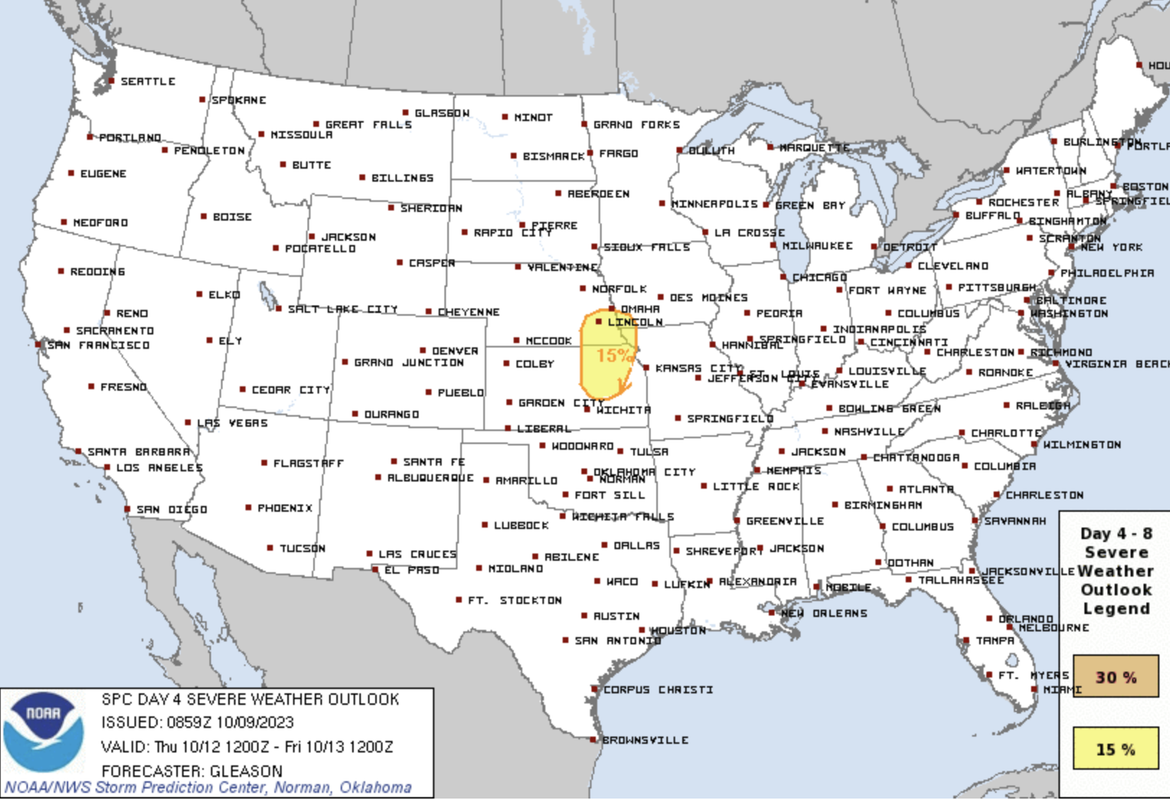
The SPC has a relatively small day 4 outlook for Thursday that includes our area which aligns with what forecast models have been showing for several days now. For reference, chances are this risk area will be expanded. It just represents the area most likely at risk "currently" based on a blend of the GFS and ECMWF forecast models. Once medium and short range models are in range, I'm assuming more areas will be added to the risk area in the coming days.
As I've mentioned a few times now, risks include the potential for supercells/tornadoes as well as damaging wind/hail - exactly where will depend on the exact track of the low/warm front and if moisture depth is sufficient (basically moisture aloft which can be lacking this time of year).
Typically with setups like this you'll get a supercell/tornado/large hail threat early on as storms first develop and then storms will grow upscale and become more of a linear damaging wind threat. Based on everything I've seen so far, this is probably what will happen with this system as well. Unfortunately our area will probably be relatively close to where the main tornado threat ends up unless things completely change (which they can still obviously).
It's worth mentioning that some scattered strong/marginally severe storms are also possible in parts of our area on Wednesday afternoon/evening as well though Thursday should be the primary severe weather day.
Day 4 Outlook:
00z ECMWF showing the potential severe weather in our area Thursday late afternoon/evening:
As I've mentioned a few times now, risks include the potential for supercells/tornadoes as well as damaging wind/hail - exactly where will depend on the exact track of the low/warm front and if moisture depth is sufficient (basically moisture aloft which can be lacking this time of year).
Typically with setups like this you'll get a supercell/tornado/large hail threat early on as storms first develop and then storms will grow upscale and become more of a linear damaging wind threat. Based on everything I've seen so far, this is probably what will happen with this system as well. Unfortunately our area will probably be relatively close to where the main tornado threat ends up unless things completely change (which they can still obviously).
It's worth mentioning that some scattered strong/marginally severe storms are also possible in parts of our area on Wednesday afternoon/evening as well though Thursday should be the primary severe weather day.
Day 4 Outlook:
00z ECMWF showing the potential severe weather in our area Thursday late afternoon/evening:
-
thenewguy
- County Board
- Posts: 4423
- Joined: Sat Oct 20, 2007 2:50 am
- Location: Council Bluffs
Re: 2023 Weather Thread
the irony of a non-tornado season tornado 'outbreak' is nuts. We spent all spring wanting to get some cool storms and stuff, now we just want it to be seasonal, and we are talkin severe weather.
Go Cubs Go
-
damonhynes

- Parks & Recreation
- Posts: 1282
- Joined: Wed Aug 27, 2014 12:35 am
- Location: Montgomery County, Texas
Re: 2023 Weather Thread
December 15th, 2021 says "Hold my eggnog!"thenewguy wrote: Mon Oct 09, 2023 1:07 pm the irony of a non-tornado season tornado 'outbreak' is nuts. We spent all spring wanting to get some cool storms and stuff, now we just want it to be seasonal, and we are talkin severe weather.
-
stormchaser
- Planning Board
- Posts: 2380
- Joined: Fri Jun 01, 2018 1:14 pm
Re: 2023 Weather Thread
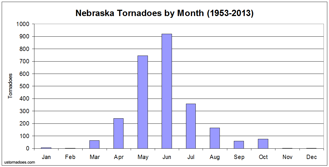
Yeah, certainly it isn't prime time for severe weather here in October but we do sometimes get a brief "second tornado season" this time of year so it isn't completely out of the ordinary.
The graph below shows Nebraska tornadoes by month. As you can see, October does see a slight spike back up when compared to September:
The graph below shows Nebraska tornadoes by month. As you can see, October does see a slight spike back up when compared to September:
-
stormchaser
- Planning Board
- Posts: 2380
- Joined: Fri Jun 01, 2018 1:14 pm
Re: 2023 Weather Thread
Saw my first December tornado that day. Now I just need to see a tornado in January and February (obviously nearly impossible around here) to have seen tornadoes in every month...
-
stormchaser
- Planning Board
- Posts: 2380
- Joined: Fri Jun 01, 2018 1:14 pm
Re: 2023 Weather Thread
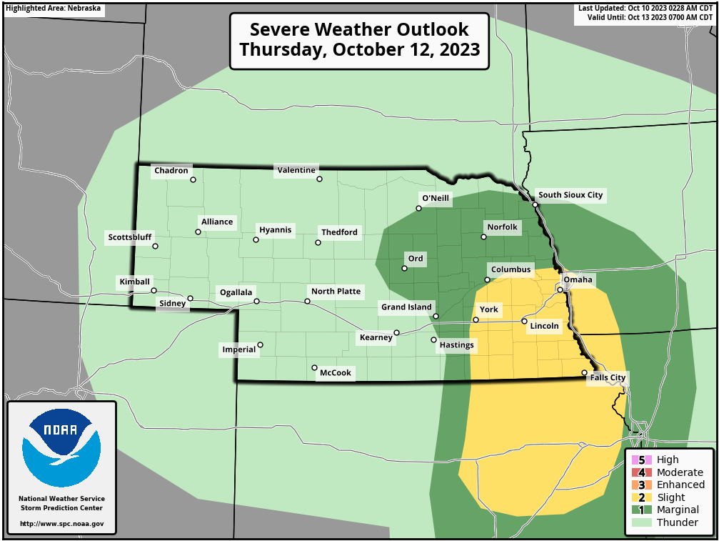
Still looking like potential for strong to severe storms and possible heavy rain in our area starting tomorrow afternoon/evening/overnight with at least some wind/hail threat and then the primary threat for severe weather on Thursday including a risk for supercells and tornadoes (in addition to damaging wind/hail).
However, there is still plenty of uncertainty as well. In particular, where exactly does the low pressure track and to what extent does moisture depth become. If moisture depth is lacking, it will reduce (or eliminate) the tornado risk for most areas though strong/severe storms (hail/wind) would still be possible considering the strength of this storm system. If moisture depth ends up higher, than a more robust tornado threat would probably exist.
It's worth mentioning the last several runs of the NAM have really backed off on the overall moisture depth on Thursday. However, the GFS and ECMWF really haven't (at least not to the same extent). Short range models should start picking up on the Thursday potential later today so hopefully that will make things a bit clearer.
Potential for snow continues to increase in western NE with at least some potential even in central NE (especially north central NE). I wouldn't be shocked to see some minor accumulations even out in western NE - maybe a few areas if it gets cold enough or if heavier snow falls after dark up to 2-3 inches of snow.
Updated SPC outlook for Thursday:
However, there is still plenty of uncertainty as well. In particular, where exactly does the low pressure track and to what extent does moisture depth become. If moisture depth is lacking, it will reduce (or eliminate) the tornado risk for most areas though strong/severe storms (hail/wind) would still be possible considering the strength of this storm system. If moisture depth ends up higher, than a more robust tornado threat would probably exist.
It's worth mentioning the last several runs of the NAM have really backed off on the overall moisture depth on Thursday. However, the GFS and ECMWF really haven't (at least not to the same extent). Short range models should start picking up on the Thursday potential later today so hopefully that will make things a bit clearer.
Potential for snow continues to increase in western NE with at least some potential even in central NE (especially north central NE). I wouldn't be shocked to see some minor accumulations even out in western NE - maybe a few areas if it gets cold enough or if heavier snow falls after dark up to 2-3 inches of snow.
Updated SPC outlook for Thursday:
-
Omaha Cowboy
- The Don
- Posts: 1013736
- Joined: Wed Jan 07, 2004 11:31 am
- Location: West Omaha
Re: 2023 Weather Thread
Thanks as always for the update..
As usual, my hope is for a rain only event..and hopefully mainly during the evening to overnight hours…
Ciao..LiO…Peace
As usual, my hope is for a rain only event..and hopefully mainly during the evening to overnight hours…
Ciao..LiO…Peace
Go Cowboys!
-
stormchaser
- Planning Board
- Posts: 2380
- Joined: Fri Jun 01, 2018 1:14 pm
Re: 2023 Weather Thread
No problem!Omaha Cowboy wrote: Tue Oct 10, 2023 7:48 pm Thanks as always for the update..
As usual, my hope is for a rain only event..and hopefully mainly during the evening to overnight hours…
Ciao..LiO…Peace
00z HRRR is in and unfortunately it’s showing a set up with potentially an even higher tornado threat late afternoon/evening (including possibly Omaha). This, of course, is one single model run but if things verify as currently shown anyway, this could end up being a pretty dangerous day.
Still plenty of time for things to change but people need to be aware and watch closely. I’m not saying 100% this is going to happen in Omaha specifically (impossible to know for sure yet) but the potential is definitely there currently at least and I’d honestly be surprised if things drastically change at this point.
-
thenewguy
- County Board
- Posts: 4423
- Joined: Sat Oct 20, 2007 2:50 am
- Location: Council Bluffs
-
stormchaser
- Planning Board
- Posts: 2380
- Joined: Fri Jun 01, 2018 1:14 pm
Re: 2023 Weather Thread
Just a quick heads up - After this update, I may not be able to post another update for a few days (just so people know if checking in for updates). My Brother from NW Iowa (and is only 46) suffered a major heart attack last week and needed to be airlifted to Sioux Falls. He has since taken a turn for the worse (so obviously I’ll be there). Thoughts and prayers would be appreciated.
Still looking like a few strong to severe storms tonight/overnight in parts of our area - primarily a scattered damaging wind/hail threat in addition to areas of heavy rain.
Tomorrow continues to look like potentially a bigger severe weather day including a risk for tornadoes. This risk appears highest currently in the Columbus to Lincoln and Omaha area and the south towards KS.
Please remain weather aware.
Still looking like a few strong to severe storms tonight/overnight in parts of our area - primarily a scattered damaging wind/hail threat in addition to areas of heavy rain.
Tomorrow continues to look like potentially a bigger severe weather day including a risk for tornadoes. This risk appears highest currently in the Columbus to Lincoln and Omaha area and the south towards KS.
Please remain weather aware.
-
Brad

- Photographer
- Posts: 1036702
- Joined: Sun Feb 29, 2004 12:03 am
- Location: Omaha, NE
Re: 2023 Weather Thread
Oh wow, sorry to hear that!

Omaha Skyline Photos, Omaha Aerial Photos, and More.
Website: www.bradwilliamsphotography.com
Facebook: www.facebook.com/bradwilliamsphotography
Twitter: www.twitter.com/bradwphoto
Instagram: www.instagram.com/bradwilliamsphotography
YouTube: www.youtube.com/@bradwilliamsphoto
-
almighty_tuna
- City Council
- Posts: 106414
- Joined: Tue Apr 13, 2004 6:34 pm
- Location: Somewhere between downtown and Colorado
Re: 2023 Weather Thread
Take care of the fam, the weather will do what it does.
-
Busguy2010
- City Council
- Posts: 7393
- Joined: Sun Apr 10, 2011 12:32 am
- Location: North Central Omaha
Re: 2023 Weather Thread
You have my positive thoughts.
It looks to be a pretty big rain even at the very least. NWS forecasting about 1.25" over the next couple days. Pretty surprising to be a severe threat now, but it's there. Looks to be mostly tomorrow around sunset.
It looks to be a pretty big rain even at the very least. NWS forecasting about 1.25" over the next couple days. Pretty surprising to be a severe threat now, but it's there. Looks to be mostly tomorrow around sunset.
-
skinzfan23
- City Council
- Posts: 11670
- Joined: Mon Feb 09, 2004 5:26 pm
- Location: Omaha/Bellevue
Re: 2023 Weather Thread
Thoughts and prayers to you and your family!
-
BRoss

- IT Director
- Posts: 10003423
- Joined: Sat Aug 05, 2006 12:39 am
- Location: West Central Omaha
Re: 2023 Weather Thread
Take care! Hope things turn out ok.
-
Omaha Cowboy
- The Don
- Posts: 1013736
- Joined: Wed Jan 07, 2004 11:31 am
- Location: West Omaha
Re: 2023 Weather Thread
So sorry to hear this news..stormchaser wrote: Wed Oct 11, 2023 6:37 pm Just a quick heads up - After this update, I may not be able to post another update for a few days (just so people know if checking in for updates). My Brother from NW Iowa (and is only 46) suffered a major heart attack last week and needed to be airlifted to Sioux Falls. He has since taken a turn for the worse (so obviously I’ll be there). Thoughts and prayers would be appreciated.
Still looking like a few strong to severe storms tonight/overnight in parts of our area - primarily a scattered damaging wind/hail threat in addition to areas of heavy rain.
Tomorrow continues to look like potentially a bigger severe weather day including a risk for tornadoes. This risk appears highest currently in the Columbus to Lincoln and Omaha area and the south towards KS.
Please remain weather aware.
Thoughts and prayers to you and your family…
Ciao..LiO…Peace
Go Cowboys!
-
thenewguy
- County Board
- Posts: 4423
- Joined: Sat Oct 20, 2007 2:50 am
- Location: Council Bluffs
Re: 2023 Weather Thread
hang in there! sendin positive vibes your way...stormchaser wrote: Wed Oct 11, 2023 6:37 pm Just a quick heads up - After this update, I may not be able to post another update for a few days (just so people know if checking in for updates). My Brother from NW Iowa (and is only 46) suffered a major heart attack last week and needed to be airlifted to Sioux Falls. He has since taken a turn for the worse (so obviously I’ll be there). Thoughts and prayers would be appreciated.
Still looking like a few strong to severe storms tonight/overnight in parts of our area - primarily a scattered damaging wind/hail threat in addition to areas of heavy rain.
Tomorrow continues to look like potentially a bigger severe weather day including a risk for tornadoes. This risk appears highest currently in the Columbus to Lincoln and Omaha area and the south towards KS.
Please remain weather aware.
Go Cubs Go
-
damonhynes
- Parks & Recreation
- Posts: 1282
- Joined: Wed Aug 27, 2014 12:35 am
- Location: Montgomery County, Texas
-
Brad
- Photographer
- Posts: 1036702
- Joined: Sun Feb 29, 2004 12:03 am
- Location: Omaha, NE
Re: 2023 Weather Thread
*I'm not a meteorologist, but I did stay at a cheap motel in Wyoming last week... 
Without Storm Chaser here, I take a stab at this. The Latest run of the HRRR shows the storms on or doorstep around 9pm and rain really intensify over us by 11pm. Looks the the better chances for sever weather are to our west and diminish as the storms move east.
Frew screen shots of the HRRR Model. NAM seems to be similar. Remember this is just one run of one model, but they seem fairly consistent the few times I have looked in the past 24 hours
Composite Reflectivity at 9pm Composite Reflectivity at 11pm Supercell Composite at 9pm Supercell Composite at 11pm Significant Tornado Parameters at 9pm Significant Tornado Parameters at 11pm Latest SPC Outlook
Without Storm Chaser here, I take a stab at this. The Latest run of the HRRR shows the storms on or doorstep around 9pm and rain really intensify over us by 11pm. Looks the the better chances for sever weather are to our west and diminish as the storms move east.
Frew screen shots of the HRRR Model. NAM seems to be similar. Remember this is just one run of one model, but they seem fairly consistent the few times I have looked in the past 24 hours
Composite Reflectivity at 9pm Composite Reflectivity at 11pm Supercell Composite at 9pm Supercell Composite at 11pm Significant Tornado Parameters at 9pm Significant Tornado Parameters at 11pm Latest SPC Outlook
You do not have the required permissions to view the files attached to this post.
Omaha Skyline Photos, Omaha Aerial Photos, and More.
Website: www.bradwilliamsphotography.com
Facebook: www.facebook.com/bradwilliamsphotography
Twitter: www.twitter.com/bradwphoto
Instagram: www.instagram.com/bradwilliamsphotography
YouTube: www.youtube.com/@bradwilliamsphoto
-
skinzfan23
- City Council
- Posts: 11670
- Joined: Mon Feb 09, 2004 5:26 pm
- Location: Omaha/Bellevue
Re: 2023 Weather Thread
I don't want anything severe, but good to know that we are still forecast to get some rain. Earlier this week WOWT kept saying most of the area was going to get 2-3", now probably a quick 30-45 min thunderstorm.
-
Cermak
- Planning Board
- Posts: 2348
- Joined: Thu Nov 29, 2018 7:02 pm
Re: 2023 Weather Thread
A really nice rain at my house this evening probably an inch or two, no high winds or hail.
-
skinzfan23
- City Council
- Posts: 11670
- Joined: Mon Feb 09, 2004 5:26 pm
- Location: Omaha/Bellevue
Re: 2023 Weather Thread
Wow, we ended up with only .30'" in Bellevue, I believe that most of Omaha saw more than that, but not the 2-3" they were predicting.
-
nebugeater

- City Council
- Posts: 111062
- Joined: Wed Aug 04, 2004 11:07 pm
- Location: Gretna NE
Re: 2023 Weather Thread
In Gretna, I dumpled out 1.1" this AM about 4:30. IT was from the last 1.5 days
For the record NEBUGEATER does not equal BUGEATER !!!!!!!
-
Cermak
- Planning Board
- Posts: 2348
- Joined: Thu Nov 29, 2018 7:02 pm
Re: 2023 Weather Thread
SW Omaha in the vicinity of 114th and W. Center area I got about 1.25 inches Thursday evening. Ended up being a pretty rainy cool weekend. Although Sunday afternoon it finally began drying out. Starting Monday the weather looks to be improving.
-
stormchaser
- Planning Board
- Posts: 2380
- Joined: Fri Jun 01, 2018 1:14 pm
Re: 2023 Weather Thread
Okay I'm back now - thanks to everyone for the kind words/support.
For the next several days, fairly typical early Fall weather is expected in our area with highs generally in the upper 60s or lower 70s and lows in the 40s and 50s.
Like normal with Nebraska Fall weather, wind will be somewhat of an issue at times (tomorrow and probably a few other days as well). Nothing crazy but enough to be annoying if you're doing things outside. However, precip chances for the next few days look pretty low with "maybe" a few scattered showers tomorrow morning.
Looking at the long range, both the GFS and ECMWF are starting to show a more active weather pattern starting again in the next 7-10 days (during the last half of next week) with several potentially strong storm systems moving through parts of the region. It's obviously impossible to know what to expect with these this far out but there would be a chance of some severe weather in the area depending on storm track and how things came together. Probably still too warm for much of a snow risk in our area yet but parts of the Dakotas may get some decent snow totals (if things verify as shown anyway which they probably won't).
Just something to keep an eye on, like normal.
For the next several days, fairly typical early Fall weather is expected in our area with highs generally in the upper 60s or lower 70s and lows in the 40s and 50s.
Like normal with Nebraska Fall weather, wind will be somewhat of an issue at times (tomorrow and probably a few other days as well). Nothing crazy but enough to be annoying if you're doing things outside. However, precip chances for the next few days look pretty low with "maybe" a few scattered showers tomorrow morning.
Looking at the long range, both the GFS and ECMWF are starting to show a more active weather pattern starting again in the next 7-10 days (during the last half of next week) with several potentially strong storm systems moving through parts of the region. It's obviously impossible to know what to expect with these this far out but there would be a chance of some severe weather in the area depending on storm track and how things came together. Probably still too warm for much of a snow risk in our area yet but parts of the Dakotas may get some decent snow totals (if things verify as shown anyway which they probably won't).
Just something to keep an eye on, like normal
.-
Omaha Cowboy
- The Don
- Posts: 1013736
- Joined: Wed Jan 07, 2004 11:31 am
- Location: West Omaha
Re: 2023 Weather Thread
Welcome back stormchaser; and as always, thank you for the eye in the sky update  …
Ciao..LiO…Peace
…Ciao..LiO…Peace
Go Cowboys!
-
stormchaser
- Planning Board
- Posts: 2380
- Joined: Fri Jun 01, 2018 1:14 pm
Re: 2023 Weather Thread
Thanks and no problem!Omaha Cowboy wrote: Wed Oct 18, 2023 2:01 pm Welcome back stormchaser; and as always, thank you for the eye in the sky update
Ciao..LiO…Peace
-
stormchaser
- Planning Board
- Posts: 2380
- Joined: Fri Jun 01, 2018 1:14 pm
Re: 2023 Weather Thread
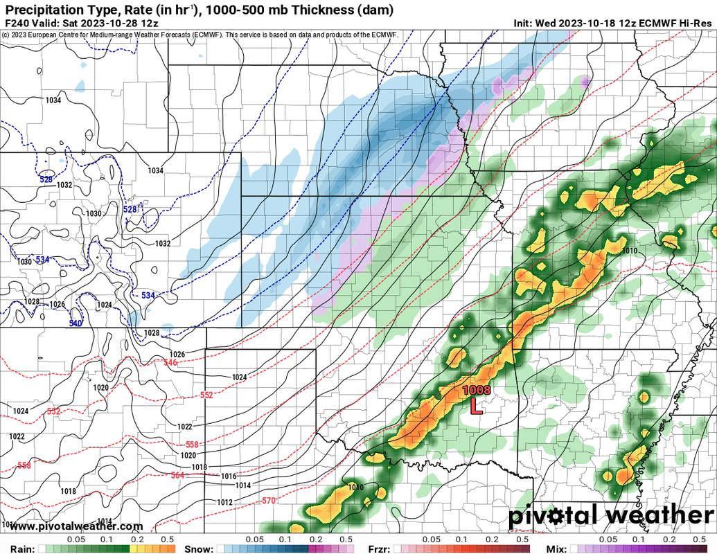
12z ECMWF is showing potential for our first flakes of snow in the long range - sometime around October 27-28th. The 12z GFS also shows snow in parts of the region in a somewhat similar time frame (though a bit further north, a day or so earlier and a stronger storm).
Obviously odds of us getting snow currently are very low considering how far out it is but since both long range models show a pretty substantial cool down and a stronger storm system somewhere in the area around that time frame, I'm expecting somewhere not far from us (if it isn't here) ends up getting some snow and pretty much all of us will get some colder weather.
The below image is from the 12z ECMWF for Friday overnight into Saturday (October 27-28th). Really anywhere from mid-week to next weekend will need to be watched though:
Obviously odds of us getting snow currently are very low considering how far out it is but since both long range models show a pretty substantial cool down and a stronger storm system somewhere in the area around that time frame, I'm expecting somewhere not far from us (if it isn't here) ends up getting some snow and pretty much all of us will get some colder weather.
The below image is from the 12z ECMWF for Friday overnight into Saturday (October 27-28th). Really anywhere from mid-week to next weekend will need to be watched though:
-
stormchaser
- Planning Board
- Posts: 2380
- Joined: Fri Jun 01, 2018 1:14 pm
Re: 2023 Weather Thread
Still looking like a chance for our first flakes of snow toward the end of next week into next weekend (models differ on timing right now).
Also, some potentially heavy rain/storms earlier in the week as the weather pattern is continuing to look like its going to become very active in the next 7-10 days.
Should be interesting...
Also, some potentially heavy rain/storms earlier in the week as the weather pattern is continuing to look like its going to become very active in the next 7-10 days.
Should be interesting...
-
skinzfan23
- City Council
- Posts: 11670
- Joined: Mon Feb 09, 2004 5:26 pm
- Location: Omaha/Bellevue
Re: 2023 Weather Thread
We definitely need the rain still.
-
stormchaser
- Planning Board
- Posts: 2380
- Joined: Fri Jun 01, 2018 1:14 pm
Re: 2023 Weather Thread
Yep, we definitely need the precip still.
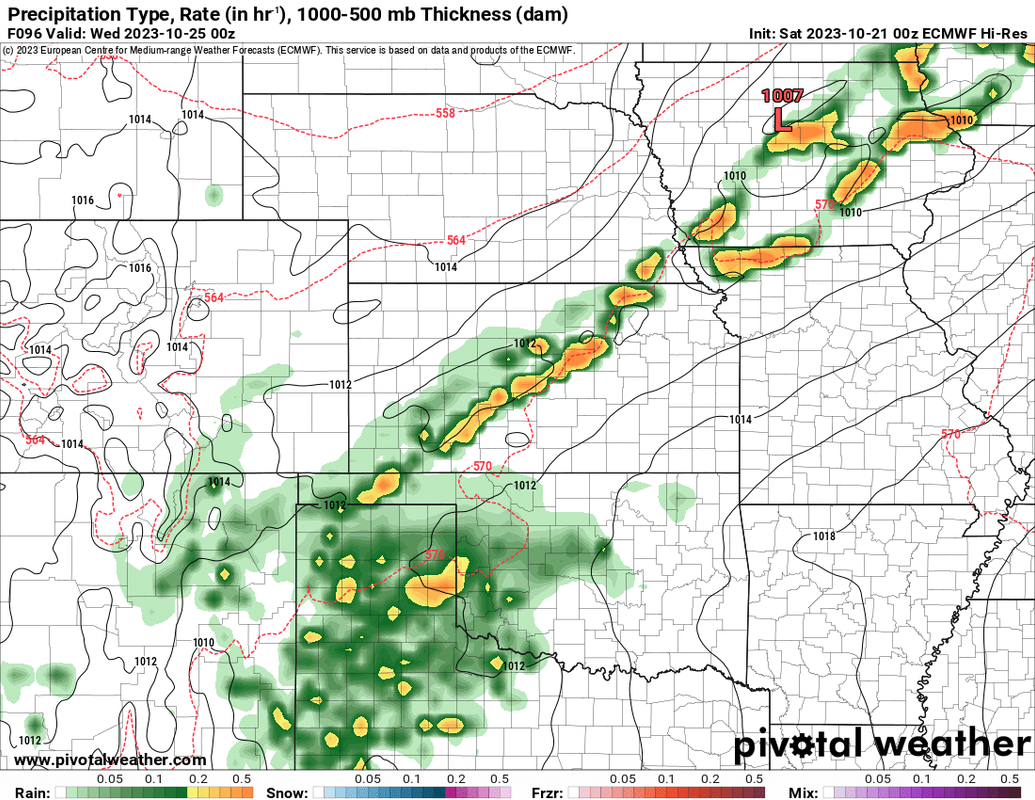
The SPC has put out a "day 4" severe weather outlook for parts of Iowa on Tuesday (not currently including our area). However, based on the 00z ECMWF, I wouldn't be surprised to see this area expanded to also include parts of western Iowa and eastern Nebraska - areas along a southeast advancing cold front which will probably be a focus for strong/severe storms on Tuesday.
This right now looks primarily to be a damaging wind/hail threat but at least some tornado potential will exist as well (probably mostly to our east closer to the low in Iowa assuming that's where the low ends up anyway).
Below is the area currently included in the day 4 outlook as well as an image of the simulated radar from the 00z ECMWF that shows what I mean with the risk area potentially being expanded into our area in future updates (with storms being shown along the cold front moving through our area).
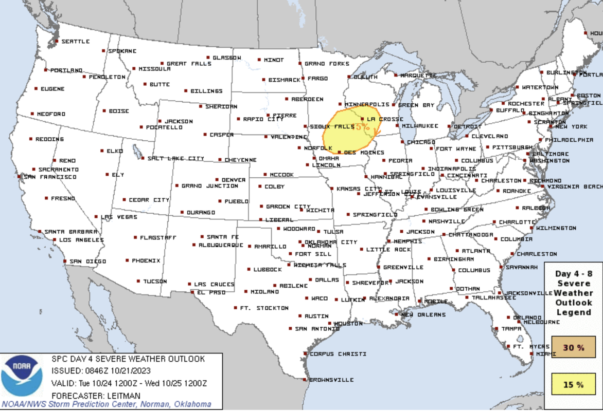
Image of the simulated radar for Tuesday based on the 00z ECMWF is below. Don't let the fact these storms appear to be southeast of Omaha in the image fool you. This is for 7 PM. They will likely develop a few hours earlier as they move southeast which means Omaha may end up at risk Tuesday - it will depend on timing of the cold front moving through.
-
stormchaser
- Planning Board
- Posts: 2380
- Joined: Fri Jun 01, 2018 1:14 pm
Re: 2023 Weather Thread
It’s worth mentioning there is additionally a severe weather threat Thursday with a second storm system, followed by a third storm system into next weekend which could be when we see our first flakes of snow.
Either way, a very active weather pattern is about to start…
Either way, a very active weather pattern is about to start…
-
almighty_tuna
- City Council
- Posts: 106414
- Joined: Tue Apr 13, 2004 6:34 pm
- Location: Somewhere between downtown and Colorado
Re: 2023 Weather Thread
I know it's just part of the weather pattern, but the weather this week is a serious bummer. It's likely going to wipe out the amazing color we have right now.