Cermak wrote: Sat Mar 30, 2024 11:25 am
Turned out to be a pretty nice day in Omaha yesterday, I cut the grass for the first time. Which is about 1 to 2 weeks earlier than I usually cut it. Dont ever recall cutting it in March before.
I cut the south facing part of my front yard too, and took quite a bit off.
I did have the mower out for mulching leaves in both January and February too, but didn't really cut any grass on those two days. I usually mow well in to December and then start again early march. I always get a couple of the neighbors worked up by mowing "Too Early" in the year... LOL
For any gardeners out there... it looks like there's potential we see our last freeze in the next few days, which if that ends up being the case, would be about two weeks earlier than normal. Though I always know there can always be an unexpected late freeze, once we get past April 14th-20th with no freeze, odds are it won't happen again.
Our 14 day forecast shows very little confidence of a freeze after this week, which would take us to April 16th.
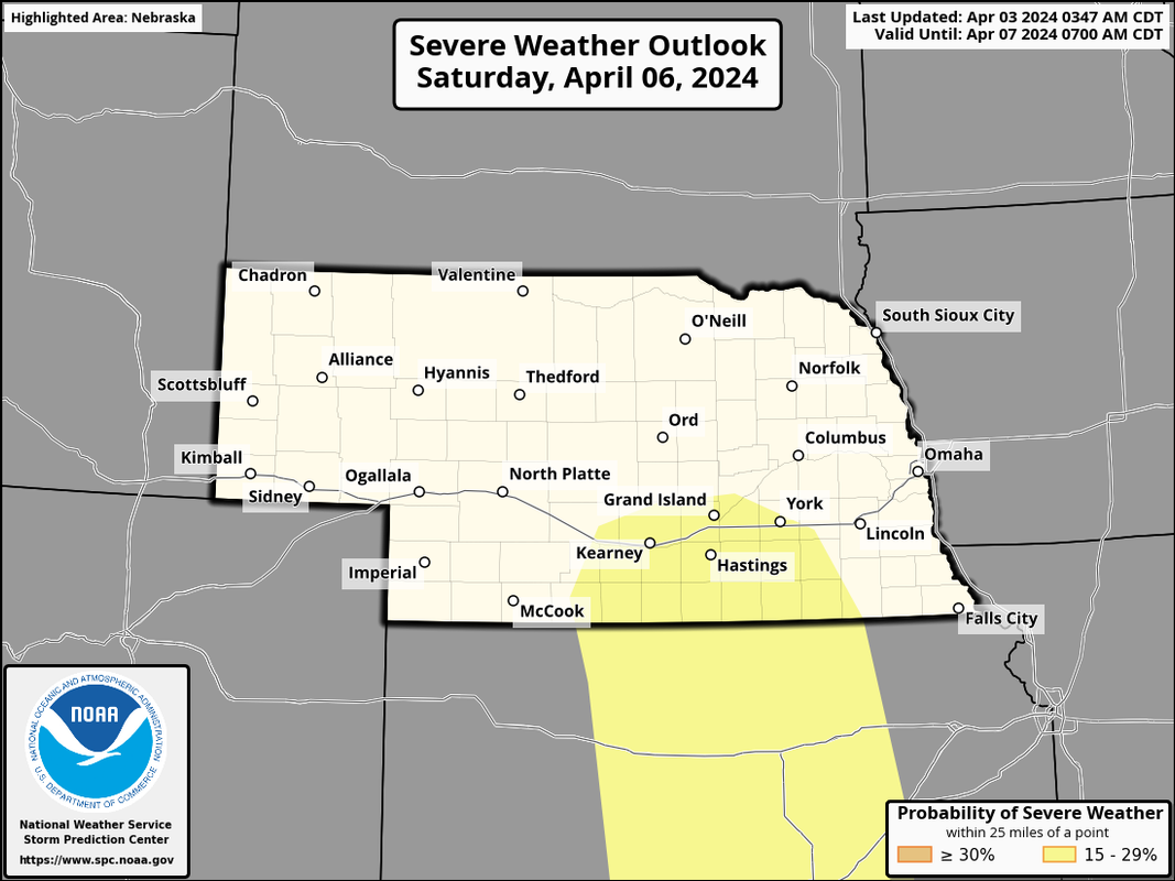
Severe weather is possible in parts of the area this coming Saturday (April 6th) as a strong storm system and cold front pushes through our area.
Below is a day 4 severe weather outlook. However, it's worth mentioning, based on model trends on the GFS and ECMWF, I wouldn't be surprised if this is adjusted north and east some (though probably still west of Omaha).
The depicted dewpoints are pretty marginal but they are slightly better on the ECMWF. Moisture return/depth will be key in how robust of a severe weather event this ends up being - which is obviously impossible to know at this point anyway but something that'll need to be watched closely.
Busguy2010 wrote: Sat Apr 06, 2024 4:48 pm
So our last freeze was April 5th, and there isn't one forecast in the foreseeable future.
So cast your vote. Will our last freeze be 4/5?
Yes
A “hard” killing freeze (as opposed to a frost) requires the temperature to fall to 28 (-3c) or lower for 4 or more hours. That is unlikely to occur again before late October or early November.
A light freeze is classified as the temperature falling below 32 (0c). Eppley often reports overnight temperatures 3-5 degrees f colder than the city proper, so while it’s very possible Eppley will dip to 32 or lower again this month it’s unlikely the city proper will suffer any sort of a freeze again this spring, in my estimation.
stormchaser wrote: Mon Apr 08, 2024 4:44 pm
Pretty good chance we will get up into the mid-80s this weekend. I'd be surprised if we have to worry about any hard freezes again until next fall.
So you are suggesting I can put my snow blower away?
For the record NEBUGEATER does not equal BUGEATER !!!!!!!
stormchaser wrote: Mon Apr 08, 2024 4:44 pm
Pretty good chance we will get up into the mid-80s this weekend. I'd be surprised if we have to worry about any hard freezes again until next fall.
So you are suggesting I can put my snow blower away?
stormchaser wrote: Mon Apr 08, 2024 4:44 pm
Pretty good chance we will get up into the mid-80s this weekend. I'd be surprised if we have to worry about any hard freezes again until next fall.
So you are suggesting I can put my snow blower away?
Lol, I put mine away like 6 weeks ago.
Thats about when I added stabilizer to the fuel in mine lol
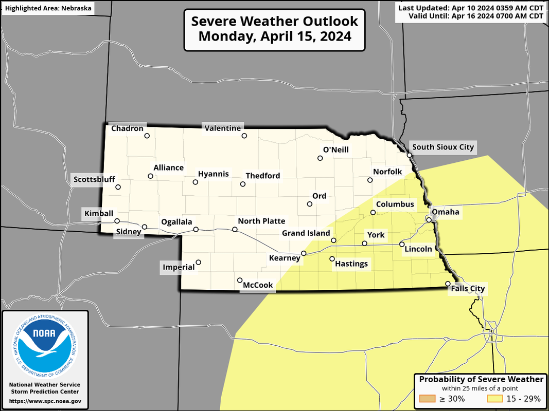
Heads up, the SPC has a day 6 severe weather outlook for this coming Monday that includes part of our area. For reference, it isn't all that common for them to issue day 6 outlooks (probably a dozen or less times per year for the entire Country - but I'm just guesstimating and it obviously can vary from year to year).
Personally, I'm seeing too much uncertainty for our area in long range models (especially with timing of everything and depth of moisture) so they may be a bit early in issuing an outlook for us IMO. Further south into parts of southern KS/western OK, etc it looks like potentially a big tornado day though along a dry line in that area.
To clarify, I'm not suggesting we won't have any severe weather in the local area - just that there is too much uncertainty currently IMO to put us in a risk area. Guess we will see as we get closer.
Anyhow, here is the area at risk in our area anyway. Don't be surprised if this changes a fair amount though...
We could use some rain. Hard to believe it’s going to be in the mid to upper 80’s this weekend and into Monday. Then another cool down, we are on a weather roller coaster.
My phone is showing a freeze next Saturday the 20th. Still a ways out but that would be a somewhat late freeze especially after temps in the 80’s. Have to wait and see as we get closer.
Cermak wrote: Fri Apr 12, 2024 11:49 am
My phone is showing a freeze next Saturday the 20th. Still a ways out but that would be a somewhat late freeze especially after temps in the 80’s. Have to wait and see as we get closer.
Is your phone going to freeze or the outside temps? Only kidding. It is a long way out but wowt shows a low of 35. I find that pretty much any app or weather info on a phone is pretty far off. My phone also shows a high of 47 for next Friday, while local stations are saying mid to upper 50's.
Cermak wrote: Fri Apr 12, 2024 11:49 am
My phone is showing a freeze next Saturday the 20th. Still a ways out but that would be a somewhat late freeze especially after temps in the 80’s. Have to wait and see as we get closer.
Is your phone going to freeze or the outside temps? Only kidding. It is a long way out but wowt shows a low of 35. I find that pretty much any app or weather info on a phone is pretty far off. My phone also shows a high of 47 for next Friday, while local stations are saying mid to upper 50's.
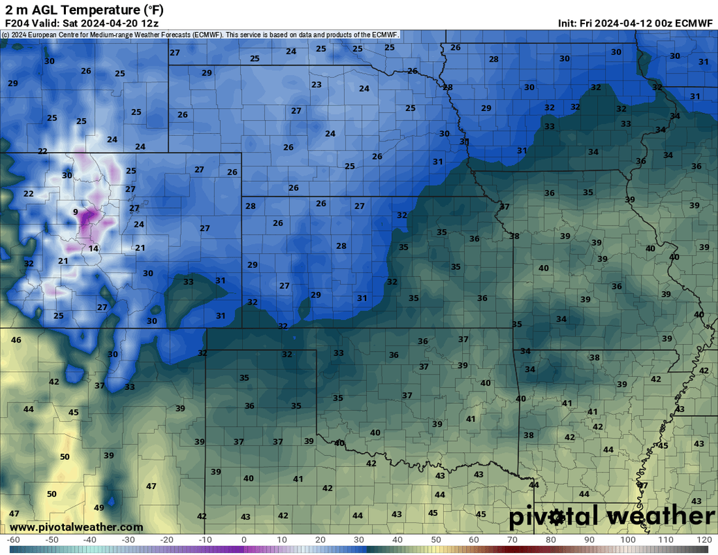
Long range 00z ECMWF shows lows getting down to around freezing in our area Friday evening. Wouldn't shock me with a strong storm system coming through early next week with potential severe weather Monday evening and possibly early Tuesday afternoon (otherwise east of here on Tuesday). Of course things are too far out yet to really know though.
This is what the 00z ECMWF is showing for lows currently:
Brad wrote: Sun Apr 14, 2024 3:06 am
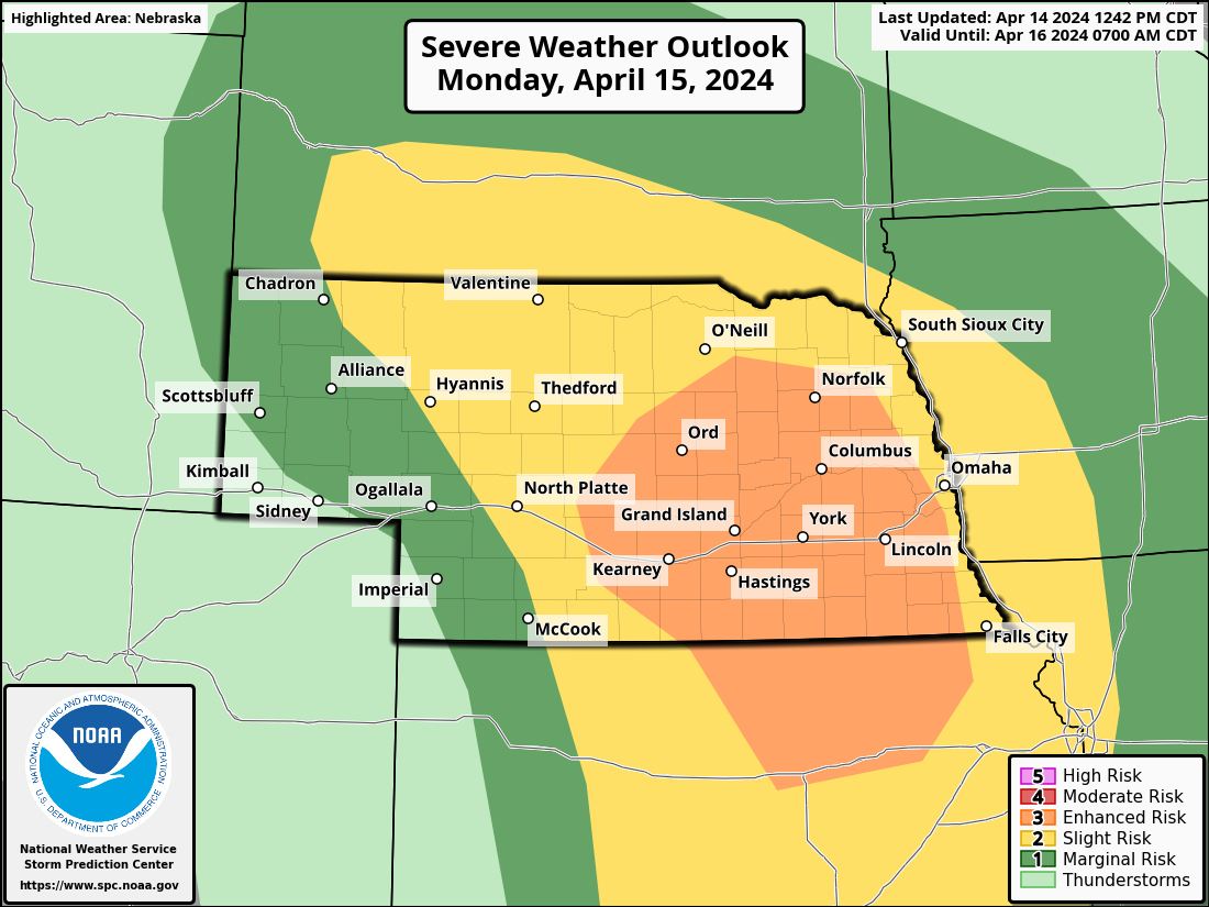
The slight risk has shifted further north and we are in the middle of it.
Screenshot 2024-04-13 220437.png
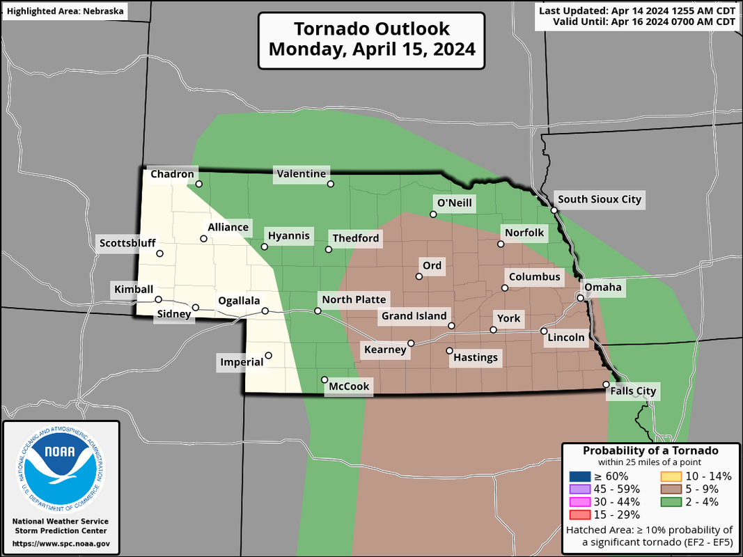
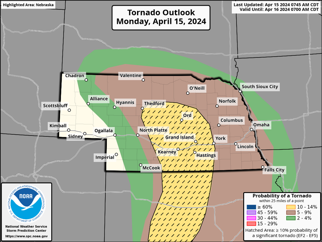
Yep, and they have a 5% tornado risk area that includes much of eastern NE - though much of the storm activity won't happen until after dark so obviously more dangerous and not really worth chasing (in most cases anyway).
Tornado risk area on Monday:
That said, I believe Tuesday will be the bigger tornado risk day in our region (albeit it "probably" will end up east of Omaha - depending on timing of things). Definitely a pretty classic tornado setup anyway with a very strong low pressure moving right over our area and storm development occurring just east of Omaha Tuesday afternoon (again, depending on timing).
Pretty decent chance I'll be out chasing Tuesday somewhere between Omaha and Des Moines.
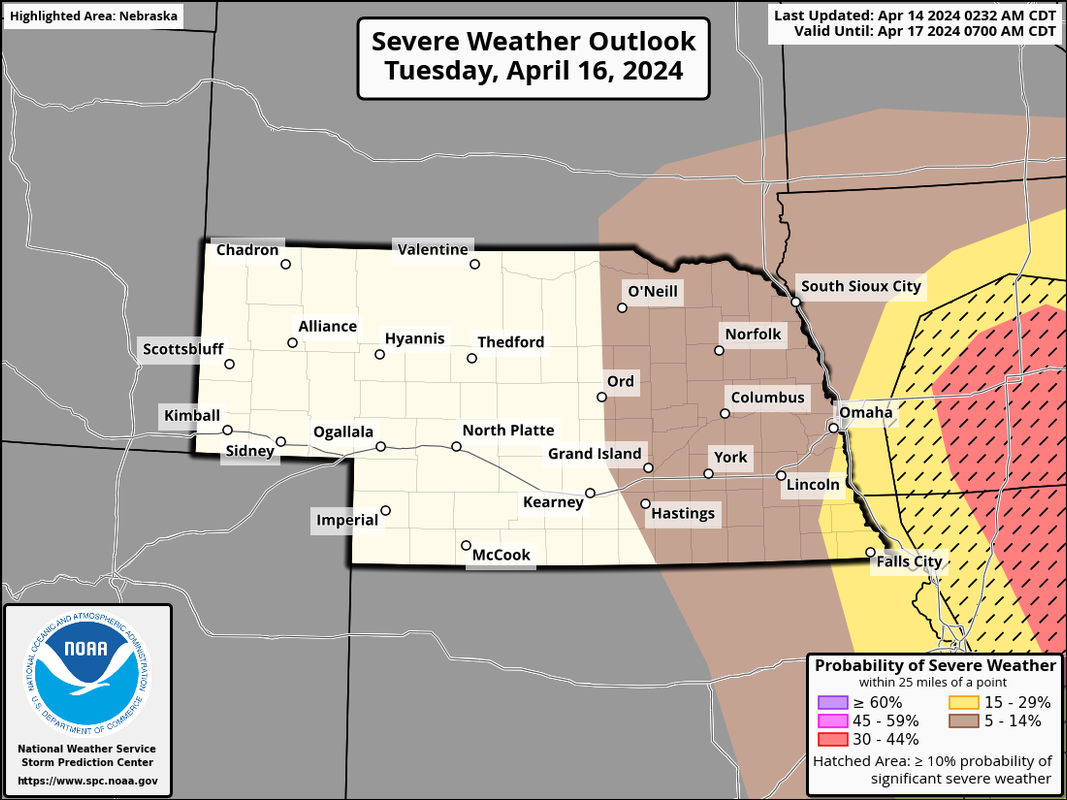
Risk map from the SPC for Tuesday (they won't have a tornado risk map until tomorrow though):
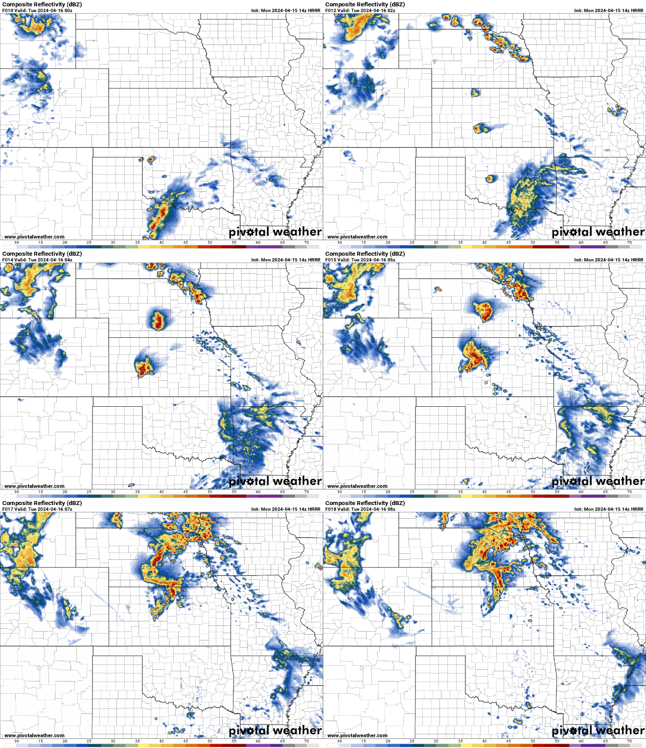
Waiting for the 12z HRRR which is loading currently to get. a better idea of what to expect Monday/Tuesday...
SPC has upgraded much of eastern NE to a “enhanced risk” (just west of Omaha) for tomorrow.
Still looking like an evening/overnight large hail, damaging wind and isolated tornado threat. IMO, Tuesday still looks like a more substantial tornado threat just east of Omaha (maybe a strong tornado threat Tuesday). Regardless, nighttime tornadoes are obviously extremely dangerous.
Enhanced risk for Tomorrow. Chances continue to increase I’ll be chasing Tuesday.
stormchaser wrote: Mon Apr 15, 2024 3:58 pm
Tornado potential has increased today - especially in parts of central NE where there is potential for strong tornadoes this evening.
Wow, it's starting to sound pretty serious. Caitlin just showed we're In the hatched area for VERY large hail. Not a good prospect there. I noticed the main chunk of what we get here is supposed to be in the morning like 7-10am. Some pretty inconvenient timing there. And another note, the main brunt of the storm looks like it's supposed to come straight from the south, if not a little southeast. Definitely a lot to get caught off guard by with this one.
Busguy2010 wrote: Mon Apr 15, 2024 5:27 pm
Wow, it's starting to sound pretty serious. Caitlin just showed we're In the hatched area for VERY large hail. Not a good prospect there. I noticed the main chunk of what we get here is supposed to be in the morning like 7-10am. Some pretty inconvenient timing there. And another note, the main brunt of the storm looks like it's supposed to come straight from the south, if not a little southeast. Definitely a lot to get caught off guard by with this one.
The bulk of the precip and severe weather, I agree. However, the HRRR has consistently produced a supercell developing in the Fremont area (roughly) between 7 PM and 9 PM that I might go chase. This storm (if it happens) would have large hail and least some tornado potential.
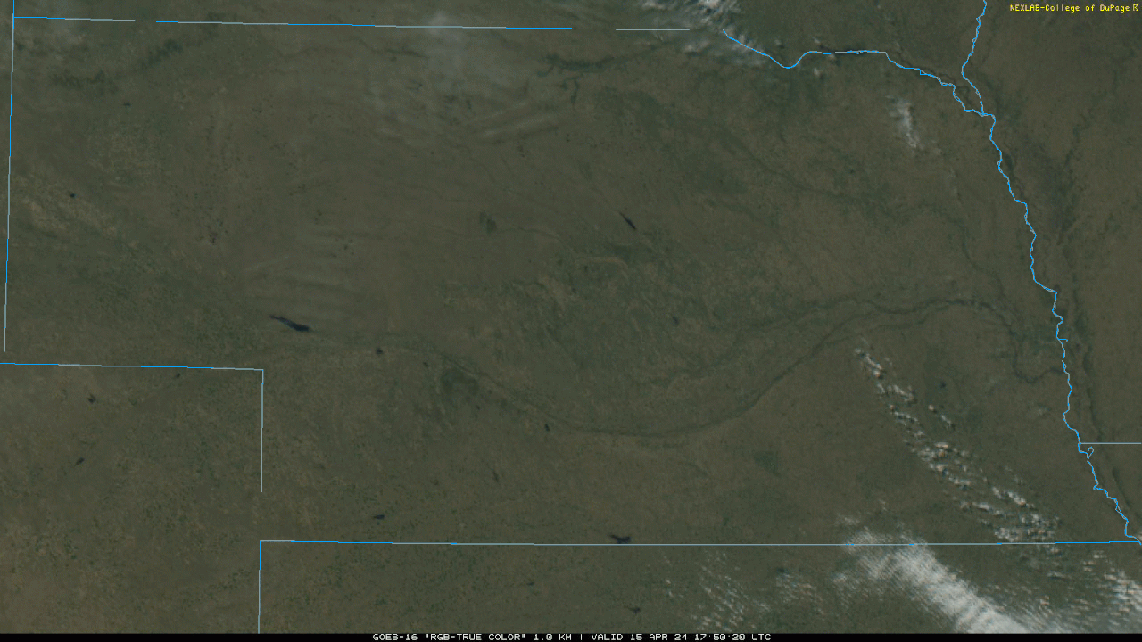
For what it's worth, the warm front is pretty obvious to see with at least some cumulus forming along it (image below from near York down towards Beatrice currently moving up this way). I still don't think anything will really get going until this evening but IF something fires along it, the area is honestly conducive for a tornado threat - especially if the southern most storm turns more northeasterly as opposed to moving more north.
Of course it's impossible to know the exact location of a sueprcell developing. Somewhere in the region whether it's Omaha, Fremont or somewhere else nearby, there is likely going to be a pretty big storm unless capping prevents it entirely (which I'd doubt happens but it's possible).
Busguy2010 wrote: Mon Apr 15, 2024 5:27 pm
Wow, it's starting to sound pretty serious. Caitlin just showed we're In the hatched area for VERY large hail. Not a good prospect there. I noticed the main chunk of what we get here is supposed to be in the morning like 7-10am. Some pretty inconvenient timing there. And another note, the main brunt of the storm looks like it's supposed to come straight from the south, if not a little southeast. Definitely a lot to get caught off guard by with this one.
Hail sucks on many levels but if we have to deal with it at least there are not crops coming up that will be destroyed with hail right now
For the record NEBUGEATER does not equal BUGEATER !!!!!!!
Busguy2010 wrote: Mon Apr 15, 2024 5:27 pm
Wow, it's starting to sound pretty serious. Caitlin just showed we're In the hatched area for VERY large hail. Not a good prospect there. I noticed the main chunk of what we get here is supposed to be in the morning like 7-10am. Some pretty inconvenient timing there. And another note, the main brunt of the storm looks like it's supposed to come straight from the south, if not a little southeast. Definitely a lot to get caught off guard by with this one.
Hail sucks on many levels but if we have to deal with it at least there are not crops coming up that will be destroyed with hail right now
It’s one of the big reasons to maintain good car insurance around these parts that’s for sure…
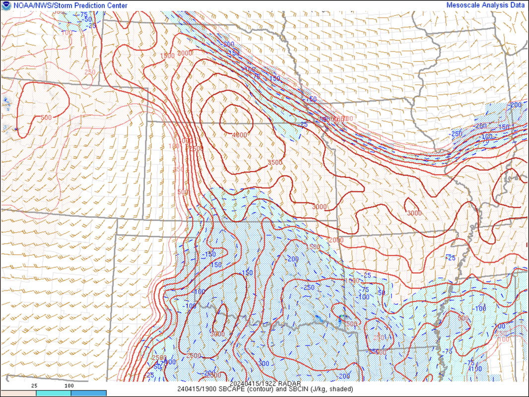
4,000 j/kj of surface based CAPE (convective available potential energy - basically a measurement of how unstable the atmosphere is) out in south central NE. These are numbers more typical during summer time. Long story short, the environment out there is explosive so if/when something does fire, it'll probably be a monster - and produce some GIANT hail.
For us, the dividing line between where CAPE and no CAPE is, is the location of the warm front. The warm front typically is a good area (if chasing) to find rotating supercells due to the backed surface winds (basically wind at the surface thats easterly/southeasterly feeding into the storm).
It'll likely feel significantly more humid in the next few hours as the warm front starts to push into our area.
Current mesoanalysis showing the area of 4,000 CAPE:
Busguy2010 wrote: Mon Apr 15, 2024 5:27 pm
Wow, it's starting to sound pretty serious. Caitlin just showed we're In the hatched area for VERY large hail. Not a good prospect there. I noticed the main chunk of what we get here is supposed to be in the morning like 7-10am. Some pretty inconvenient timing there. And another note, the main brunt of the storm looks like it's supposed to come straight from the south, if not a little southeast. Definitely a lot to get caught off guard by with this one.
Hail sucks on many levels but if we have to deal with it at least there are not crops coming up that will be destroyed with hail right now
For sure. I was going to get my plants in the ground today, but after hearing that forecast for hail, I'll hold off. It sounds like a fairly sure bet.
Storm initiation is starting to occur west of Kearney, NE (based on visible satellite). Strong tornadoes will be possible in that area over the next few hours...
There was no rain yet in Gretna when I left home at about 5 AM. There were a few drops as I was driving towards Fremont, but nothing that required the wipers yet. There was some indication that there was some rain earlier towards Fremont because of wet roads and puddles. Lots of lightning though so had a good light show.
For the record NEBUGEATER does not equal BUGEATER !!!!!!!
Tornado watch was issued at 4, going til 8. We have one decent looking cell coming up the river right now. It kinda looks like that may be the main one they were talking about. It doesn't look all that impressive, but I suppose we'll find out here soon.
I may be tricking myself, but the sky looks very slightly green. Anyway it's knocking on our doorstep. Such a weird direction for a storm to come. I have essentially no view to the south.
Pretty underwhelming so far, but looks like there might be a bit of training going on now with small storms popping up following the river essentially. Then down by KC is where the real action is happening. I have doubts we're gonna see much.
iamjacobm wrote: Tue Apr 16, 2024 2:01 pm
I will be curious how much downtown or eppley got bc it was pretty steady since midnight with some heavy bursts on the east side of town.
According to them, the 7 and 8 o'clock hours were the only substantial rainfall periods. That would have been for that main cell that came through. 0.28", and a very brief marble size hail. I heard one close cg strike followed by a very brief downpour around maybe midnight. Overall I'm not impressed.
Hopefully what we have a chance for later will amount to something. I can call it satisfactory if we total .5" for the day. But again, I have my doubts. We're more likely to be done for the day.